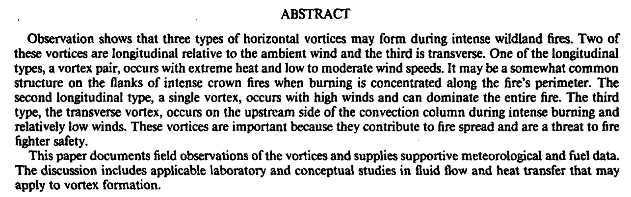
Above: screenshot from the Wall Fire time-lapse video below.
This time-lapse video of the Wall Fire condenses one hour of high intensity fire behavior into a one minute video. It was photographed using the camera system operated by the Nevada Seismological Lab between 7 p.m. and 8 p.m. on July 8, 2017, the day after the fire started. Since then it has burned 5,800 acres and destroyed 41 homes and 55 other structures southeast of Oroville, California.
If you are interested in wildland fire behavior, you may be fascinated by the occasionally counter-rotating as well as single horizontal and vertical vortices as the fire rapidly spreads across the landscape.
This phenomenon is important to firefighters because of the extreme fire behavior that can put personnel in immediate danger.
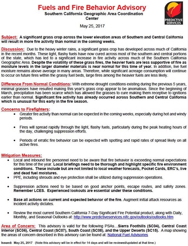
The Southern California Geographic Area Coordination Center has issued a Fuels and Fire Behavior Advisory for the central and southern areas of California due to a heavier than usual grass crop brought on by above average winter rains. Because of the vegetation and climate in Southern California it seems like we hear similar warnings often — heavy rains bring lots of flashy grass fuels, and a dry winter results in low fuel moistures. An average winter can mean typical fire potential, which in this area can still mean large devastating wildfires. But as we often say, the most important factor that affects the number of acres burned is the weather during the fire season.
Below is an excerpt from the Advisory. Following that is the entire document.
****
“Due to the heavy winter rains, a significant grass crop has developed across much of California in the recent months. These light, flashy fuels have now cured across most of the southern and central portions of the state, which has led to a significant increase in fire activity across much of the Southern California Geographic Area. Despite the volatility of these grass fires, the heavier fuels are less supportive of fire as moisture levels in the larger diameter materials is near normal for this time of year. In addition, live fuel moisture remains above average in many areas. Therefore, while significant acreage consumption will continue to occur on future fires within the grassy fuel beds, large fires among the heavier fuels are less likely.”
Thanks and a tip of the hat go out to Ken. Typos or errors, report them HERE.
Above: The U.S. Forest Service tests burning pine straw in an IBHS wind tunnel earlier this year. Screen grab from IBHS video.
The Insurance Institute for Business and Home Safety (IBHS) will host a live wildfire-related event on Facebook Wednesday November 9 at 10:30 a.m. EST. They have not provided a ton of information about but it will “open up the curtain a bit on wildfire studies”. (Link to the IBHS Facebook Page.)
Dr. Steve Quaries will discuss the wildfire research that they have been doing in the huge wind tunnel. In 2011 using 105 huge fans and spark-generators, they launched embers at a structure to demonstrate what can happen when a wind-driven fire approaches a poorly prepared structure.
The IBHS wind tunnel showing the 105 fans. IBHS photo.
The video below shows embers igniting flammable material on and around a structure in the IBHS wind tunnel.
Earlier this year the U.S. Forest Service used the facility to study the relationship between wildland fire rate of spread and wind speed used in the U.S. wildland fire behavior decision support systems. Previous experiments have been conducted in the Missoula Fire Sciences Laboratory wind tunnel that is more limited in size and wind speed than the IBHS wind tunnel.
This research is a collaborative effort with researchers at UNC Charlotte, University of Maryland, University of Texas Austin, and USDA Forest Service, and is funded by the Joint Fire Science Program.
One of the Predictive Services offices, it is unclear which one, distributed this advisory. Our opinion is that when someone provides technical advice, or suggests that others take action or modify their behavior, they should be accountable.
****
Fuels and Fire Behavior Advisory
Southern Area
Southern Appalachian Mountains
October 7-21, 2016
Subject: Increasing Fire Danger in area of Hurricane Matthew subsidence
Discussion: An area of exceptional drought with Energy Release Component values above the 90th percentile currently exists over an area covering a large portion of the Southern Area. With the passage of Hurricane Matthew along the east coast relative humidity values are forecast to drop into the teens over this area. There will also be a high likelihood of gusty winds, especially along the western face of the Appalachian Mountains.
Difference from normal conditions: The area of subsidence associated with Hurricane Matthew will exacerbate the already dry environment and move ERC values over a large area above the 97th percentile over the next 10 days.
Concerns to Firefighters and the Public: Any fire in this area will be very resistant to control efforts. Expect complete consumption of fuels down to mineral soil or rock, frequent torching, and increased spotting. Fire intensities will be higher than normal which will likely preclude direct attack of fires. Expect the need for extended mop-up. Expect an increase in long duration fires; with heavy fuels being available to burn and leaves coming off of trees expect a higher than normal probability of re-burn on contained fires.
Mitigation Measures: Do not expect any fire to be routine. Be prepared to utilize indirect tactics with extended mop-up. Utilize aerial supervision to help direct crews and keep them informed on fire behavior. Ensure that LCES is in place before engaging on any fire. Remember to STOP, THINK and TALK before you ACT…actively look for ways to minimize risk to firefighters in what is forecast to be a period of very high fire danger.
Area of Concern: Alabama, Mississippi, Central and north Georgia, Tennessee and the mountain areas of Western South Carolina and North Carolina.
Teepee Springs Fire, August 29, 2015, as seen from Island Bar in Idaho. InciWeb photo.
Allison Linville, a former aircraft dispatcher for the U.S. Forest Service, wrote an interesting article for High Country News, saying last year’s fires pushed wildland firefighters to the edge.
Below is an excerpt:
****
“…In Montana, fire managers were watching fire models and using their extensive training and experience to manage fires just as they always had, only to have people on the ground begging them to understand that they were seeing something totally different. “Their models weren’t showing what a beast it actually was,” said a firefighter on the Flathead National Forest. She was talking about a fire that she barely escaped before it blew up.
It occurred to me last August that wildfires have become qualitatively different. And it was a disturbing thought, the realization that no one had the ability to manage fire anymore. Fire managers can’t understand the fires we have today, because their training and experience are no longer relevant to modern-day fires.
Given the conditions now piling up — hot summers, long fire seasons, low snowpack, heavy fuel loading, an ignorant public, erratic storms — there is simply not enough education or experience available to help teach a fire manager what to do. It’s not the managers’ fault; it’s not any one person’s fault.”
Above: Nebraska Forest Service Simtable. Screen grab from the KOTO video below.
We have written before about the Simtable that can project a spreading fire and an aerial photo onto a sand table that has been sculpted to resemble the topography for that area. It is an excellent training tool to simulate a potential fire or an actual on-going fire.
In this report from KDUH/KOTA the system recently acquired by the Nebraska Forest Service is described, including features that were new to me.
Below is an excerpt from the news coverage:
…NFS Fire Management Specialist Seth Peterson says the simulation gives fire officials advance knowledge of what they would need to do if a fire breaks out in a certain area. It could also make a big impact during a real wildfire event. A smartphone app for firefighters in the field can add valuable, on-site information to the simulator to make it react in real time.
“That iphone will know where he is on the map, and the IC (Incident Commander) will be able to see exactly where that firefighter is on the line. The firefighter can then update off his phone and basically feed the IC all the information he needs to be making all the decisions, without even being on the fire,” says Peterson…
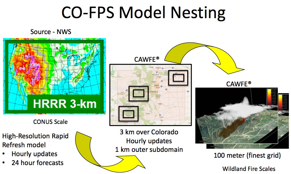
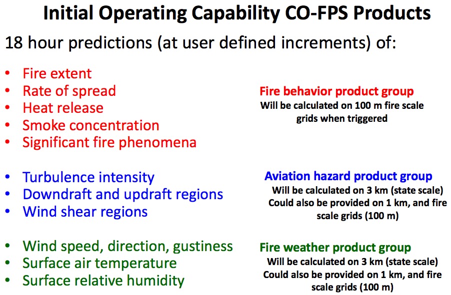
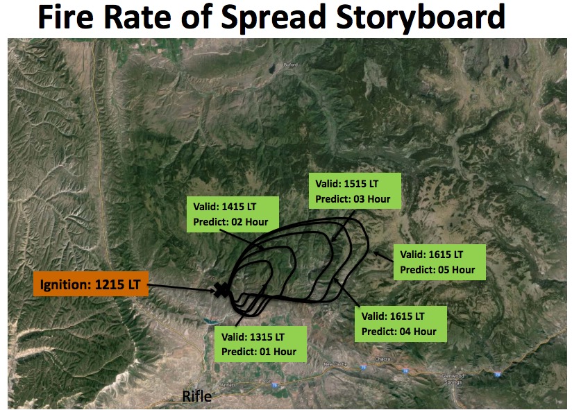
The decision support system that Colorado is developing is expected to provide frequently updated fine-scale predictions of weather that affects wildfires, and the behavior of going fires. It will use heat detected by satellites and hourly weather forecast updates from the National Weather Service to produce maps showing fire managers where multiple fires are expected to spread in the next 12 to 18 hours.
Much of the work is being done under contract for the state by the National Center for Atmospheric Research, a federally funded program headquartered in Boulder, in cooperation with the University Corporation for Atmospheric Research. The organizations have distributed a detailed briefing document on the development schedule and a time line for deliverables, which you can read HERE (1.9 MB).
Below are a few images from the document.
—————
—————
We have criticized the state of Colorado for not having their crap together for organizing and planning for the management of wildfires or for on-the-ground fire suppression, but they are developing some significant resources for gathering intelligence with their new fixed wing aircraft and now with this decision support system that will provide frequently updated predictions of fire spread using state of the art technology.
Their next logical step is to develop a management system and the firefighting resources to make use of this wealth of information. While there are some firefighting organizations that could use this data to their advantage and convert it to actions on the fire ground, at this stage it’s like *putting lipstick on a pig, at least within the Colorado Division of Fire Prevention and Control.
*In 1992 Ann Richards, the former Governor of Texas, said at a South Dakota barbecue, “You can put lipstick on a hog and call it Monique, but it is still a pig”.
A modern smartphone has many times the processing power of the computers on the Apollo spacecraft that took astronauts to the moon. Increasingly, wildland firefighters in the field are taking advantage of the smart brilliant devices in their pockets.
An article published in Fire Management Today (in the third quarter of 2015) covers two smart phone applications, or apps. After the user inputs the current weather and environmental conditions they can calculate various parameters and share them via mail or use various archiving options. One of the apps even uploads data to a remote computer server where advanced simulations can be performed which then return forecasts for the next 3 to 12 hours.
Fire Weather Calculator
(These images are screen shots from the app.)
Below, FDFM and PIG, are Fine Dead Fuel Moisture and Probability of Ignition. The app can harvest information from the smart phone and insert it into the fields, including time, date, latitude, longitude, and elevation.
From Fire Management Today:
This application allows the user to input traditional observations (e.g., dry bulb, wet bulb, etc.) and have the application calculate critical information, such as relative humidity and probability of ignition, which both saves time and ensures consistency between weather observers. More importantly, however, is the ability to archive and share these digital observations with other users and managers in real time. This application allows for more streamlined management of weather information, a critical aspect of any fire event. The ability to share observations, particularly if many users are archiving their observations, will lead to a very useful archive of crowd-sourced data that will be used to create value-added products, such as the calculations of 3-dimensional weather fields that could be shared with personnel to increase their situational awareness.
The Topofire Weather app takes the weather calculations to the next level, however it is no longer available. In searching for it we contacted one of the authors of the article, Matt Jolly, a research ecologist at the Missoula Fire Sciences Laboratory, who told us that it has been removed because they “are working on better options for displaying geographic information across all devices, rather than just a few platforms. We are almost ready to release it but development is going slowly right now.”
Topofire Weather looks like it was rather intriguing, as you can see from the description in Fire Management Today:
Similar to the Fire Weather Calculator app described above, this application allows users to enter a suite of fire weather observations that are normally collected on incidents. These observations, as well as the time and location, are sent directly to the TOPOFIRE server, where they are permanently archived and can be made available to users and fire weather forecasters. Weather information entered into the phone can then be used to parameterize the WindNinja simulation model, using either current observations or gridded data from the Real-Time Mesocale Analysis dataset (RTMA).
Users can also request forecasts for the next 3 to 12 hours, using data from the National Digital Forecast Database. Model simulations are then run on the TOPOFIRE server, and outputs are returned to the user’s phone in the form of a keyhole markup language (.KML) file that can be opened on the phone on GoogleEarth.
(The image above is from the article in Fire Management Today. Click on it to see a larger version.)
The Topofire Weather app apparently required access to government computer servers, which may prevent the ordinary user from being able to take advantage of its entire functionality.
We will look forward to the next generation of the app.