
Prescribed fire at Everglades National Park HQ
I have conducted prescribed fires near structures, but not THIS close.
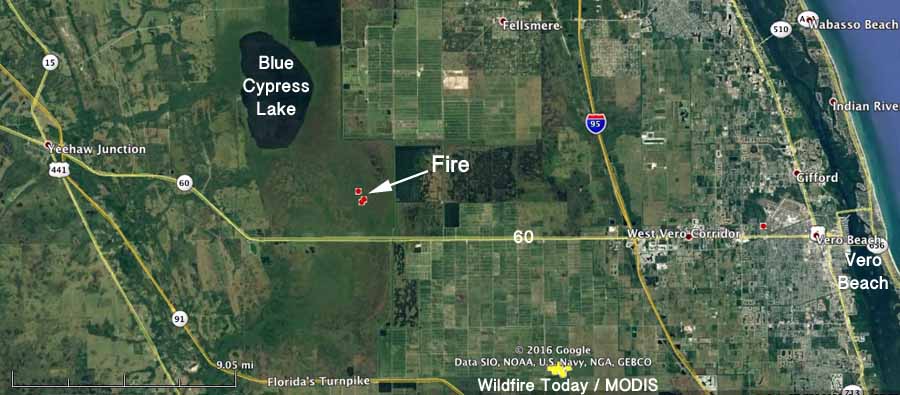
Fire in Indian River County, Florida

Above: Aerial photo of the fire in Blue Cypress Conservation Area, October 24, 2016. Florida Forest Service.
(UPDATED at 1:30 p.m. EDT October 25, 2016)
The Florida Forest Service reported today that the wildfire east of Vero Beach, named the Johnny Marsh Fire, self-extinguished when the grass fire reached willow trees. The estimate of 1,000 acres will be updated after an aerial recon Tuesday afternoon.
The photo below is from Monday.
#IndianRiverCounty UPDATE Blue Cypress Con Area @SJRWMD #wildfire is now 1,000 acres. It’s 3 miles long (North to S) & one mile wide (E to W pic.twitter.com/nNLmeheDD8
— FFS Okeechobee (@FFS_Okeechobee) October 24, 2016
****
(Originally published at 5:14 p.m. EDT October 24, 2016)
The Florida Forest Service is responding to a wildfire in Indian River County in the Blue Cypress Conservation Area 19 miles west of Vero Beach. At 4 p.m. EDT they reported it was about 1,000 acres, and three miles long (north-south) by 1 miles wide.
The fire was reported Sunday evening and continues to grow on Monday.

Painting with flame

Jennifer Brown, who has produced at least six excellent short films featuring wildland fire, partnered with the former Fire Management Officer at Everglades National Park, Rick Anderson, to make this video, Burning Florida. The footage was gathered at a prescribed fire last week in the Florida Dry Prairie at Kissimmee Prairie Preserve State Park. The film has shots from the air (quadcopter) and ground along with the dedication from Mr. Anderson.
Florida Forest Service demonstrates their tracked firefighting vehicle

The Florida Forest Service gave WSVN a look at one of their tracked firefighting vehicles.
Long Pine Key Fire in Everglades National Park
The fire is burning between the Main Park Road and the Nike Missile Base.
Continue readingWildfire in Martin County, Florida burns 136 acres

Firefighter takes compelling photos of Florida wildfire.
Continue readingPrescribed fire at Sunnier Palms Nudist Park

The Florida Forest Service announced that they conducted a five-acre prescribed fire today.
Prescribed fire at Everglades National Park

Everglades National Park conducted a prescribed fire yesterday, February 21, 2016.

National Park Service photos by Gary Carnall.
Wildfire Briefing, February 5, 2016

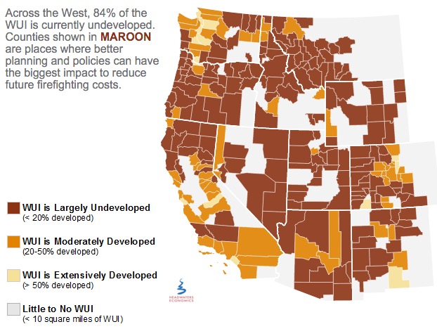
The above image is from Headwaters Economics
Land use planning to reduce wildfire risk
Headquarters Economics released a report about how five cities have used innovative land use planning techniques as a way to adapt to the growing threat from wildfires. The authors met with city planners, elected officials, and firefighters in Austin, Texas; Boulder, Colorado; Flagstaff, Arizona; San Diego, California; and Santa Fe, New Mexico—all communities with a recent history of wildfire and a reputation for being problem solvers.
Prescribed fire escapes in Florida
In St. Johns County, Florida on Tuesday a prescribed fire intended to treat 140 acres off County Road 208 escaped control when an unexpected 20-25 mph wind gust scattered burning embers. About 270 acres later the Florida Forest Service was able to contain the blaze.
Spokesperson Julie Maddux said statewide in 2015 the Florida Forest Service burned more than 236,000 acres during prescribed fires and none of them got out of control.
U.S. Forest Service releases findings on the effects of drought for forests and rangelands
The U.S. Forest Service this week released a new report, Effects of Drought on Forests and Rangelands in the United States: A Comprehensive Science Synthesis, that provides a national assessment of peer-reviewed scientific research on the impacts of drought on U.S. forests and rangelands. This report will help the Forest Service better manage forests and grasslands impacted by climate change.
“Our forests and rangelands are national treasures, and because they are threatened, we are threatened,” said Agriculture Secretary Tom Vilsack. “This report confirms what we are seeing, that every region of the country is impacted by the direct and indirect effects of drought conditions and volatile weather patterns. Sixty million Americans rely on drinking water that originates on our 193 million acres of national forest and grasslands. They support 200,000 jobs and contribute over $13 billion to local economies every year.”
Utah seeks jail time for drone operators that interfere with wildfire operations
Last year there were numerous instances across the West of drones flying into the airspace above active fires and interfering with the operations of firefighting aircraft.
From the AP:
..A new proposal in the Utah Legislature aims to address the growing problem by creating a possible penalty of jail time for people who fly drones within 3 miles of a wildfire.
A House committee was scheduled to discuss the proposal Tuesday afternoon but the hearing was postponed.
Republican Rep. Kraig Powell of Heber City, the proposal’s sponsor, said he asked to postpone the meeting so he could get more input from interested parties. He said he may add exemptions for certain entities, such as public utility companies that need to use drones to see if the fire will impact gas lines.
Jason Curry of the Utah Division of Forestry said he hopes lawmakers back the bill…
“I really hope it doesn’t take a major mishap and somebody to lose their life for the public to take it seriously,” Curry said.
Washington state treats less land with prescribed fire than their neighbors

From the Seattle Times:
Washington lags far behind neighboring states in using controlled burns to thin out dangerously overgrown woodlands.
After back-to-back years of catastrophic forest fires, some state lawmakers want that to change.
“I’ve had it. I think it is time to delve into the policy,” said state Sen. Linda Evans Parlette, R-Wenatchee, who represents a large swath of North Central Washington scorched in last year’s record-setting fires that burned more than 1 million acres.
Parlette is sponsoring a pair of “fight fire with fire” bills that would require more controlled burns on state lands and loosen smoke regulations to make it easier for federal and private land managers to conduct burns.
Experts say expanding the use of controlled burns is vital to restoring forests to health, leaving them less vulnerable to massive blazes when the summer fire season hits.
But some U.S. Forest Service officials and other critics say the state’s Department of Natural Resources (DNR), led by Commissioner of Public Lands Peter Goldmark, has discouraged controlled burns in recent years because of fears over smoke drifting into communities.