There’s only one way in and out of the Canadian municipality of Whistler.
The Coast Mountains surround the forested British Columbia town north of Vancouver, giving Whistler its world-renowned trait of being North America’s largest ski resort community. The rocky slopes, however, occasionally cause transportation problems for Whistler’s residents. Highway 99, the only passage through the southern parts of the mountain range, stands as residents’ only escape route during times of emergency.
Whistler firefighters reflect on the 2023 wildfire season
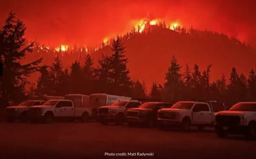
The frequently suffocated roadway and recent devastating wildfires in the nearby communities of West Kelowna and Kelowna pushed the perennially snow-focused municipality to begin serious planning for a potential fire disaster. Most Whistler neighborhoods are classified as “interface,” but the wildland and ornamental fuel load between residences have characteristics of an “intermix,” or homes being within a forest community. Because of this, Whistler scores high in the plan’s “overall fire risk” category.
Whistler’s pervasive forest primarily drove town officials to take a more proactive approach to wildfire defense in its creation of a community wildfire defense plan.
Whistler firefighters reflect on the 2023 wildfire season
“Typically when a wildfire is approaching a community, these defense plans are done at the time as it’s approaching,” Whistler Fire Chief Thomas Doherty told Global News journalists for a recent article. “Obviously wildfire specialists will come in and assist with doing these neighborhood defense plans. We’ve done that in advance. We believe we’re one of the first municipalities to do this type of plan, to have this information readily available ahead of time.”
Whistler firefighters reflect on the 2023 wildfire season
The approach Doherty references includes increasing FireSmart education for residents and visitors, changing municipal legislation and community planning with a wildfire resiliency focus, increasing interagency and firefighters’ wildfire response, and continuing strategic vegetation management efforts.
Global News, in their conversation with Doherty, reports that one of the tools created from this plan includes 19 tactical sheets and GIS maps for various critical infrastructure and water source locations, identifying which neighborhoods have a one-way-in and one-way-out access, and safe zones for responders during times of emergency. All this information will reportedly be available to fire personnel through scannable QR codes.
“Extremely critical to have all this information done in advance,” Doherty said. “It’s just unfortunate when an event does occur. At least we’re that much more prepared. And we have all that information readily available.”
You can read the full Whistler Community Wildfire Defense Plan [HERE].
The Coast Mountains surround the forested British Columbia town north of Vancouver, giving Whistler its world-renowned trait of being North America’s largest ski resort community. The rocky slopes, however, occasionally cause transportation problems for Whistler’s residents. Highway 99, the only passage through the southern parts of the mountain range, stands as residents’ only escape route during times of emergency.
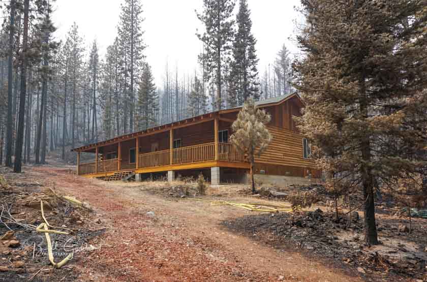
One of the homes that survived the Eiler Fire in northern California, August, 2014. Photo by Bill Gabbert.
Beginning January 1 in California the seller of a home in a designated high fire area built before 2010 must disclose to the buyer conditions that make the home vulnerable to wildfires.
The seller must provide documentation stating that the property is in compliance with local laws pertaining to defensible spaces or local vegetation management laws. If there is no such local law, the seller shall provide documentation of compliance with state law, assuming the seller obtained such documentation within six months prior to entering into the transaction. But if neither of the above, the seller and the buyer must enter into a written agreement in which the buyer agrees to obtain documentation of compliance with defensible space or a local vegetation management ordinance after close.
Here are the details from the legislation:
Disclosures re Home Hardening
Beginning January 1, 2020, if a seller, after completion of construction, has obtained a final inspection report regarding compliance with, among other things, home hardening laws (Gov’t Code 51182 and 51189*), the seller shall provide to the buyer a copy of that report or information on where a copy of the report may be obtained.
Beginning January 1, 2021, this law requires for properties located in high or very high fire hazard severity zones for homes built before 2010, delivery of a notice to include the following three items:
1. A statutory disclosure that includes information on how to fire harden homes as follows:
“This home is located in a high or very high fire hazard severity zone and this home was built before the implementation of the Wildfire Urban Interface building codes which help to fire harden a home. To better protect your home from wildfire, you might need to consider improvements. Information on fire hardening, including current building standards and information on minimum annual vegetation management standards to protect homes from wildfires, can be obtained on the internet website http://www.readyforwildfire.org.”
2. Disclosure of a list of features that may make the home vulnerable to wildfire and flying embers if the seller is aware. The list includes, among other things, untreated wood shingles, combustible landscaping within five feet of the home, and single pane glass windows.
3. On or after July 1, 2025, a list of low-cost retrofits re home hardening (listed pursuant to Section 51189 of the Government Code*). The notice shall disclose which listed retrofits, if any, that have been completed during the time that the seller has owned the property.
Potential point of sale compliance requirements re defensible space or local vegetation management laws
Beginning July 1, 2021 seller of property in high or very high fire hazard zones shall provide documentation to the buyer stating that the property is in compliance with laws pertaining to state law defensible spaces (Public Resources Code 4291**) or local vegetation management ordinances, or in certain cases the buyer and seller will agree that the buyer is to obtain the documentation after close as follows
1. If there is a local ordinance requiring the seller to comply with state law governing defensible spaces (PRC 4291**) or a local vegetation management ordinance, the seller shall provide the buyer with: 1) a copy of the documentation of such compliance, and 2) information on the local agency from which a copy of that documentation may be obtained.
2. But If no such local ordinance exists, and the seller has obtained an inspection from a state, local or other government agency or qualified nonprofit which provides an inspection with documentation for the property, the seller shall provide the buyer with: 1) the documentation of the inspection if obtained within six months prior to entering into a transaction to sell the real property and 2) information on the local agency from which a copy of that documentation may be obtained.
3. If seller hasn’t obtained documentation of compliance per 1 or 2 above, then the seller and buyer shall enter into a written agreement stating that the buyer agrees to: a) obtain documentation of compliance per the local ordinance or b) if there is no such local ordinance, the buyer shall, within one year, obtain documentation of compliance as long as there is a state, local or other government agency or qualified nonprofit which provides an inspection with documentation of compliance for the property.
This law also requires the California Office of Emergency Services (Cal OES) to enter into a joint powers agreement with the Department of Forestry and Fire Protection (Cal FIRE) to administer a comprehensive wildfire mitigation and assistance program to encourage cost-effective structure hardening and facilitate vegetation management, contingent upon appropriation by the Legislature.
Marin County fire history 1917-2020. The blue areas were all prior to 1980. NIFC map.
Many residents and government officials in Marin County recognize the importance of evacuation planning, but there is no agreement on which agency has the responsibility. In March voters approved a parcel tax that would raise about $19 million each year for the newly formed Marin Wildfire Prevention Authority (WPA), but the county’s Civil Grand Jury ruled in December that the agency’s plans do not adequately address the issue.
Marin County, outlined in red. (Google)
From the Marin Independent Journal:
Part of that funding will go toward studying evacuation routes, creating evacuation maps and clearing vegetation along narrow Marin roads. But the agency does not have the authority or the funding to take on infrastructure projects that could create safer roads for people fleeing wildfires, the grand jury said.
“The grand jury is concerned that Marin’s public may have a false sense of security regarding evacuation routes, thinking that all issues relating to the matter will be handled by the new government agency,” the report says.
While Marin County fire Chief Jason Weber agreed that the wildfire authority doesn’t have the funding to take on road infrastructure projects, he said the agency is taking the initial step in addressing Marin’s evacuation safety problem.
Marin County, population 258,826, is bordered on the west by the Pacific Ocean and stretches from the Golden Gate Bridge north to Bodega Bay and east to Novato and San Pablo Bay.
Evacuation planning will likely point out a need for road infrastructure projects, for which the WPA does not have funding. The Transportation Authority of Marin, or TAM, is the only agency in the county with access to funding and authority over countywide transportation projects. The grand jury recommended that a representative from TAM serve as a non-voting member of the WPA.
Marin County Civil Grand Jury, Wildfire Preparedness: A New Approach, Appendix C, April 25, 2019.
Fire officials in Marin County have identified “choke points” where residents are likely to get caught in congestion when evacuating from wildfires. Since many of those run through multiple jurisdictions, the grand jury said TAM should serve as the coordinating agency but TAM officials “continue to deny that the agency has any role or responsibility for considering evacuation needs in its transportation projects.”
Community infrastructure and planning was one of the six categories of actions Wildfire Today pointed out in April, 2019 that must be taken to reduce the impact of wildfires on communities. That category includes:
Road and driveway width, wide enough for large fire trucks
Turnarounds at the end of roads
Signage, and
Emergency water supply.
The other five categories that need to be considered in fire-prone communities are home spacing/lot size; envelope of the structure itself; home ignition zone; wildland-urban interface; and fire codes.
While I was watching the Clemson vs. Mississippi State University basketball game today on ESPN2 I didn’t expect to hear words of wisdom or a pithy quote. One of the announcers was Chris Spatola, a former basketball player for Army West Point who is also a veteran. After only 8 minutes into the game MSU had thrown in “tons of three-pointers.” As they talked about how Clemson had hoped to limit MSU’s three-pointers, Mr. Spatola said,
Everybody has a plan until they get punched in the mouth.
The other announcer, Jon Sciambi, recognized the quote as being from Mike Tyson who had been asked by a reporter whether he was worried about Evander Holyfield and the fight plan he had bragged about.
After Mr. Spatola did an impression of Mr. Tyson, Mr. Sciambi said, “I am going to enjoy working with Chris Spatola.”
As a Planning Section Chief on Incident Management Teams, of course I appreciate the necessity of planning. And I think Mr. Tyson’s quote while it at first seems crude and simplistic, actually is worth thinking about and can have multiple messages. The most obvious is that yes, you have a plan, but you encounter difficulties and quickly realize that you’re going to need a Plan B. If you prepared for an alternate strategy, you might succeed after all. If not, well, thanks for playing and here is your Participation Trophy.
Another interpretation is that after encountering unexpected problems, you don’t throw in the towel, but you have the guts and perseverance to keep fighting and working through the complications, eventually achieving the goal and overcoming the odds stacked against you.
Helmuth Von Moltkex said:
No plan survives contact with the enemy.
Bob Robins told me about a good plan on a wildfire that was poorly briefed and executed. He was in one group of firefighters that was attempting to stop the spread of a fire at night by burning out along a road, working toward another group that started at the other end. The objective was to burn the vegetation between the road and the fire, removing the fuel. The fire would then be stopped in that area. When the two groups met, they were horrified to find that they had ignited opposite sides of the road, and they suddenly had a lot more fire to deal with.
General Norman Schwarzkopf directed the planning and strategy to kick the Iraqis out of Kuwait after they invaded the country in 1990. His plan was based on overwhelming force using strong infantry attacks supported by artillery and armor after bombing the crap out of them from the air for weeks. It worked. The ground fighting in Desert Storm was over within about 100 hours. Not long after, most of the U.S. troops returned home. I have latched on to his strategy when writing about using the concept of overwhelming force for the initial attack of new wildfires. It can often be successful, and then everybody goes home and prepares for the next one, not getting bogged down and tying up resources and taxpayer dollars in a months-long campaign.
Here are some other planning-related quotes. Do you have a favorite, or an example of a plan that worked? Or didn’t?
“In preparing for battle I have always found that plans are useless, but planning is indispensable.”
― Dwight D. Eisenhower
“Give me six hours to chop down a tree and I will spend the first four sharpening the axe.”
― Abraham Lincoln
“By failing to prepare, you are preparing to fail.”
― Benjamin Franklin
“A goal without a plan is just a wish.”
― Antoine de Saint-Exupéry
If you don’t know the past, you can’t understand the present and plan properly for the future.”
― Chaim Potok, Davita’s Harp
“I wasn’t planning to lead, I was standing in the back and then everyone turned around.”
― Avery Hiebert
“No matter what the work you are doing, be always ready to drop it. And plan it, so as to be able to leave it.”
― Leo Tolstoy, The Journal of Leo Tolstoy
“If you don’t know where you are going, you’ll end up someplace else.”
― Yogi Berra
Area Command Team 2 led by Tim Sexton was assigned to the Southern California Operations Center in mid-September to assist with strategic planning for the rest of the fire year.
These screen shots are borrowed from a PowerPoint presentation the team developed (3.6 Mb) of the likely fire activity, scheduled resource availability, likely resources needs, the gap between needs and availability, and suggestions on how to address the gap.
The group looked back at the previous four years of fire activity and the use of firefighting resources to help predict what the needs are going to be during the rest of the calendar year, or “Fire Year” as we are hearing these days. Of those four years, one was an outlier, 2019, with much less fire activity than average, so it was not used to predict resource needs. The 2,210,266 acres burned in the 49 states outside of Alaska in 2019 was the lowest total since 2004. Almost twice that many acres have already burned in just California so far this year, according to CAL FIRE October 2, 2020.
The slides shown here are 11 of the 15 in the presentation.
While I was watching the Clemson vs. Mississippi State University basketball game today on ESPN2 I didn’t expect to hear words of wisdom or a pithy quote. One of the announcers was Chris Spatola, a former basketball player for Army West Point who is also a veteran. After only 8 minutes into the game MSU had thrown in “tons of three-pointers.” As they talked about how Clemson had hoped to limit MSU’s three-pointers, Mr. Spatola said,
Everybody has a plan until they get punched in the mouth.
The other announcer, Jon Sciambi, recognized the quote as being from Mike Tyson who had been asked by a reporter whether he was worried about Evander Holyfield and the fight plan he had bragged about.
After Mr. Spatola did an impression of Mr. Tyson, Mr. Sciambi said, “I am going to enjoy working with Chris Spatola.”
As a Planning Section Chief on Incident Management Teams, of course I appreciate the necessity of planning. And I think Mr. Tyson’s quote while it at first seems crude and simplistic, actually is worth thinking about and can have multiple messages. The most obvious is that yes, you have a plan, but you encounter difficulties and quickly realize that you’re going to need a Plan B. If you prepared for an alternate strategy, you might succeed after all. If not, well, thanks for playing and here is your Participation Trophy.
Another interpretation is that after encountering unexpected problems, you don’t throw in the towel, but you have the guts and perseverance to keep fighting and working through the complications, eventually achieving the goal and overcoming the odds stacked against you.
Helmuth Von Moltkex said:
No plan survives contact with the enemy.
Bob Robins told me about a good plan on a wildfire that was poorly briefed and executed. He was in one group of firefighters that was attempting to stop the spread of a fire by burning out along a road, working toward another group that started at the other end. The objective was to burn the vegetation between the road and the fire, removing the fuel. The fire would then be stopped in that area. When the two groups met, they were horrified to find that they had ignited opposite sides of the road, and they suddenly had a lot more fire to deal with.
General Norman Schwarzkopf directed the planning and strategy to kick the Iraqis out of Kuwait after they invaded the country in 1990. His plan was based on overwhelming force using strong infantry attacks supported by artillery and armor after bombing the crap out of them from the air for weeks. It worked. The ground fighting in Desert Storm was over within about 100 hours. Not long after, most of the U.S. troops returned home. I have latched on to his strategy when writing about using the concept of overwhelming force for the initial attack of new wildfires. It can often be successful, and then everybody goes home and prepares for the next one, not getting bogged down and tying up resources and taxpayer dollars in a months-long campaign.
Here are some other planning-related quotes. Do you have a favorite, or an example of a plan that worked? Or didn’t?
“In preparing for battle I have always found that plans are useless, but planning is indispensable.”
― Dwight D. Eisenhower
“Give me six hours to chop down a tree and I will spend the first four sharpening the axe.”
― Abraham Lincoln
“By failing to prepare, you are preparing to fail.”
― Benjamin Franklin
“A goal without a plan is just a wish.”
― Antoine de Saint-Exupéry
If you don’t know the past, you can’t understand the present and plan properly for the future.”
― Chaim Potok, Davita’s Harp
“I wasn’t planning to lead, I was standing in the back and then everyone turned around.”
― Avery Hiebert
“No matter what the work you are doing, be always ready to drop it. And plan it, so as to be able to leave it.”
― Leo Tolstoy, The Journal of Leo Tolstoy
“If you don’t know where you are going, you’ll end up someplace else.”
― Yogi Berra
Half of our Holy Grail of Firefighter Safety is for firefighters and their supervisors to know the real time location of firefighting resources working on an incident. The other half is to know the real time location of the fire. These two pieces of information would greatly enhance the situation awareness and safety of the personnel. Not knowing this information has led to dozens of firefighter fatalities.
Keno, Oregon has spearheaded the development of a system that takes care of the the first half of the Holy Grail — showing the location of firefighters on a map. This is one of several systems nationwide that is being used by local organizations in the United States. Theirs goes far beyond that, however, and can display detailed information about structures.
Gene Rogers helped put the system together which has grown to include Klamath County. He sent us this description.
****
Klamath County Situation Analyst (KCSA) and Situation Analyst Field Tool (SAFT)
Decades of collaboration and experience with incident management challenges formed the premise of the goals and objectives developed by a rural fire chief, a retired federal fire manager turned consultant, and a state district forester. Brainstorming sessions often focused on a theme of what would make emergency management more efficient. The need for current information on emerging incidents that could be easily shared across the spectrum of cooperators was a goal. Their vision was to collect incident information at initial response that could be easily passed on as the incident evolved to extended response and ultimately to an IMT (Incident Management Team). Another goal was to minimize repetition, redundancy and confusion throughout any incident. Applicability to any incident; structure fire, wildland fire, rescue, flood, earthquake, weather event, was a fundamental objective. Traditional paper maps and hand written notes contain information not readily shared with incoming responders. KCSA and SAFT are applications to enhance the sharing of information and greatly increase public and responder safety. These applications offer real-time, shareable, interoperable information on a common operating platform.
Following the completion of the Keno, Oregon Community Wildfire Protection Plan (CWPP) in 2003 attention was turned to gathering structure and parcel fuels data for Wildland Urban Interface (WUI) properties. In 2006 grant funds were used to recruit and train summer interns to collect the data on 10,000 Klamath County WUI residential properties.
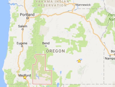
Klamath County, Oregon, outlined in red.
Current technology allowed for data collection on handheld data recorders, GPS units, and digital cameras. The data was assembled using commercial software from RedZone Software. Individual reports on each WUI structure and parcel included construction attributes (roof, siding, etc.), wildland fuel conditions, a photo of the structure and a composite risk score. The collected data was distributed to responding districts and agencies on compact discs and hard copy maps. The data and resultant hazard ratings were used in the 2007 Klamath County CWPP. The information was valuable but the project managers also wanted technology that allowed rapid sharing of data across the emerging technology of smart phones, tablet computers, and laptops.
By 2013 the project steering committee had selected Intterra, a company specializing in geospatial information technologies, to integrate the Klamath County structure survey data, collection process, and other information into a modified version of their Situation Analyst named KCSA. Additional capabilities requested included Automatic Vehicle Location (AVL), real-time incident mapping on touch screen devices, structure pre-plan data collection, and a property owner feedback process. The Yarnell Hill Fire of June 2013 emphasized the need for managers to know the location of incident resources. KCSA and SAFT incorporate the capability to track resources by cell phone GPS or commercial GPS tracking devices on vehicles and personnel. The 2016 Klamath County CWPP update discusses the uses of KCSA and SAFT.
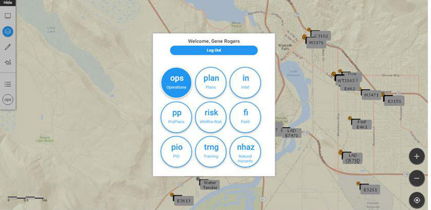
Firefighting resources show up on the display.
KCSA is an application for connected devices that offers the full array of system capabilities. SAFT is an application that can be downloaded to mobile devices (from the App Store or Google Play). SAFT can be used whether or not the device is connected to the internet. Mapping, collected data, and pictures can be shared to users of KCSA when the device is connected. Example: field data can be collected in terrain without connectivity, then uploaded to the KCSA system when connectivity is achieved. Use of either application requires a Login ID and Password. Permissions to various capabilities are assigned when the user profile is established. This can be done pre-incident locally or at an incident when checking in arriving resources.
Permissions to use features in the applications relate to specific users and their level of qualification on incidents. For example: a Field Observer (FOBS) cannot edit the map prepared by someone with Operations permissions (OSC1/OSC2, OPBD, DIVS). Other capabilities relate to specific tasks. The Pre Plans (PP) module allows structure fire departments to map buildings with key information critical to their fire and rescue work. The available workspaces are tailored to the needs of that functional area, e.g., Plans or Public Information Officer.
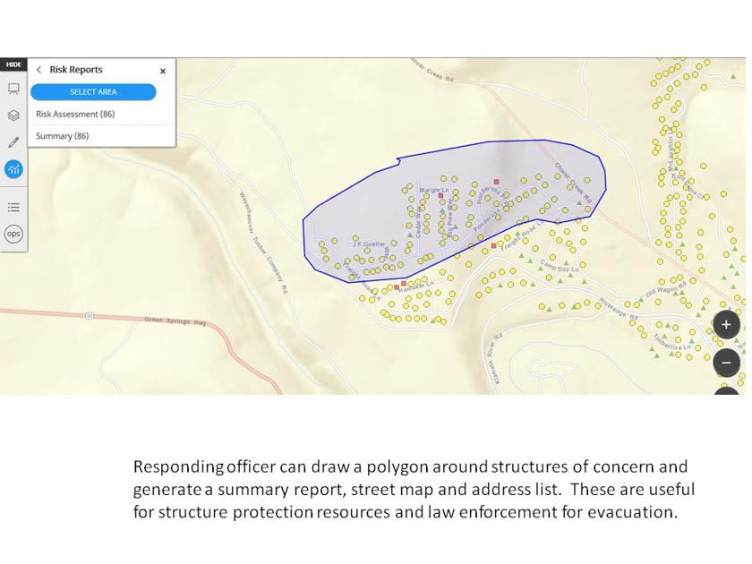
The Risk module compiles the wildfire risk survey data for structures and parcels in the surveyed data. An onsite survey for a new structure and parcel can be completed in minutes. This is particularly useful for structure protection and evacuation planning in areas where surveys have not already been completed.
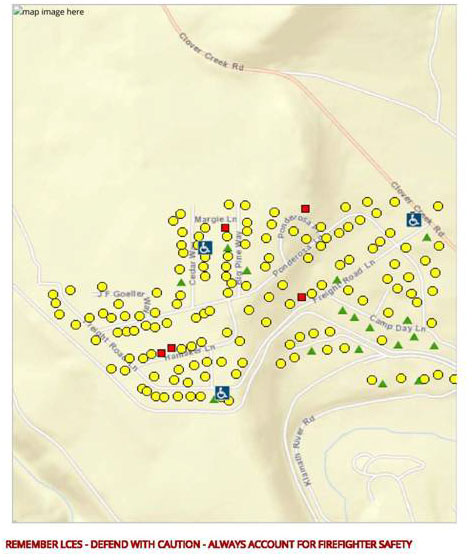
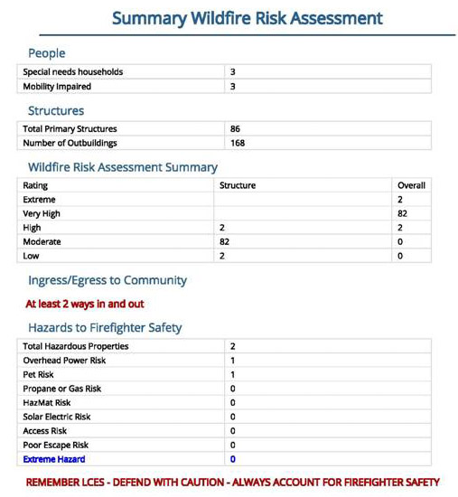
Summary of the circled area.
Once surveyed, the user can circle the structures of concern and produce a map and address list to pass to Law Enforcement for evacuation. This takes seconds when the structures have been previously surveyed. Home symbol and color correspond to assigned risk score and rating adjective. Homeowners can view their risk score at www.kcrsg.org.
Use of the applications is spreading in the emergency management organizations of Oregon. The Oregon State Fire Marshal (OSFM) is supporting the use of the applications by OSFM Incident Management Teams. KCSA was used on wildfires in the southeast states in 2016. Klamath County fire districts, Oregon Department of Forestry, and federal wildland fire agencies are currently using the software. Use of the applications is spreading into several other counties in Oregon. Grant monies funded the development of the applications. Future expenses will be nominal and shared proportionally by users for the cost of the hosting server. The software is free of charge.
This is a brief discussion of the development and capabilities of the KCSA and SAFT applications. Those interested in further information about Situation Analyst should contact Intterra at info@intterragroup.com. Questions about the use of KCSA and SAFT can be sent to firechief@kenofire.com.
The state of Utah has developed a plan to mitigate and prevent the adverse impacts of what they call “catastrophic wildfires”. A 25-person steering committee wrote the document which identifies 14 statewide pilot projects
designed to offer the greatest positive impact on community
safety, water supply, utility and transportation
infrastructure, and damage to waterways and reservoir
storage. The projects include public education, improved address and road signage, the acquisition of more fire apparatus, and various types of fuel treatments. The estimated cost of the 14 projects is $129 million.
Considering what has been going on in Utah during the last couple of years I was surprised to not see anything in the plan about taking over federal land to turn it over to the state or private companies.
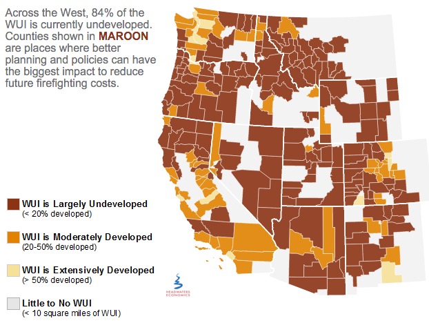
Headquarters Economics released a report about how five cities have used innovative land use planning techniques as a way to adapt to the growing threat from wildfires. The authors met with city planners, elected officials, and firefighters in Austin, Texas; Boulder, Colorado; Flagstaff, Arizona; San Diego, California; and Santa Fe, New Mexico—all communities with a recent history of wildfire and a reputation for being problem solvers.
Headwaters Economics
Prescribed fire escapes in Florida
In St. Johns County, Florida on Tuesday a prescribed fire intended to treat 140 acres off County Road 208 escaped control when an unexpected 20-25 mph wind gust scattered burning embers. About 270 acres later the Florida Forest Service was able to contain the blaze.
Spokesperson Julie Maddux said statewide in 2015 the Florida Forest Service burned more than 236,000 acres during prescribed fires and none of them got out of control.
U.S. Forest Service releases findings on the effects of drought for forests and rangelands
“Our forests and rangelands are national treasures, and because they are threatened, we are threatened,” said Agriculture Secretary Tom Vilsack. “This report confirms what we are seeing, that every region of the country is impacted by the direct and indirect effects of drought conditions and volatile weather patterns. Sixty million Americans rely on drinking water that originates on our 193 million acres of national forest and grasslands. They support 200,000 jobs and contribute over $13 billion to local economies every year.”
Utah seeks jail time for drone operators that interfere with wildfire operations
Last year there were numerous instances across the West of drones flying into the airspace above active fires and interfering with the operations of firefighting aircraft.
From the AP:
..A new proposal in the Utah Legislature aims to address the growing problem by creating a possible penalty of jail time for people who fly drones within 3 miles of a wildfire.
A House committee was scheduled to discuss the proposal Tuesday afternoon but the hearing was postponed.
Republican Rep. Kraig Powell of Heber City, the proposal’s sponsor, said he asked to postpone the meeting so he could get more input from interested parties. He said he may add exemptions for certain entities, such as public utility companies that need to use drones to see if the fire will impact gas lines.
Jason Curry of the Utah Division of Forestry said he hopes lawmakers back the bill…
“I really hope it doesn’t take a major mishap and somebody to lose their life for the public to take it seriously,” Curry said.
Washington state treats less land with prescribed fire than their neighbors
Washington lags far behind neighboring states in using controlled burns to thin out dangerously overgrown woodlands.
After back-to-back years of catastrophic forest fires, some state lawmakers want that to change.
“I’ve had it. I think it is time to delve into the policy,” said state Sen. Linda Evans Parlette, R-Wenatchee, who represents a large swath of North Central Washington scorched in last year’s record-setting fires that burned more than 1 million acres.
Parlette is sponsoring a pair of “fight fire with fire” bills that would require more controlled burns on state lands and loosen smoke regulations to make it easier for federal and private land managers to conduct burns.
Experts say expanding the use of controlled burns is vital to restoring forests to health, leaving them less vulnerable to massive blazes when the summer fire season hits.
But some U.S. Forest Service officials and other critics say the state’s Department of Natural Resources (DNR), led by Commissioner of Public Lands Peter Goldmark, has discouraged controlled burns in recent years because of fears over smoke drifting into communities.



 Global News, in their conversation with Doherty, reports that one of the tools created from this plan includes 19 tactical sheets and GIS maps for various critical infrastructure and water source locations, identifying which neighborhoods have a one-way-in and one-way-out access, and safe zones for responders during times of emergency. All this information will reportedly be available to fire personnel through scannable QR codes.