Holy Fire spreads east into Riverside County

The fire has burned at least 4,129 acres northwest of Lake Elsinore, California

Above: The view of the Holy Fire from Santiago Peak at 10:40 a.m. PDT August 8, 2018.

(Originally published at 10:51 a.m. PDT August 8, 2018)

The Holy Fire was very active Tuesday night and Wednesday morning, moving east down the steep slope below the North Main Divide road in the Cleveland National Forest in Southern California. The fire started Monday afternoon in Trabuco Canyon about three miles west of the North Main Divide road. That road roughly follows the ridge top through the Santa Ana Mountains between the Ortega Highway (74) and Corona . The boundary between Orange and Riverside Counties also follows that ridge.

(To see all articles about the Holy Fire on Wildfire Today, including the most recent, click HERE.)

With the assistance of air tankers, firefighters had been able to minimize the growth on the east side of the ridge in Riverside County. But on Wednesday morning the fire has progressed quite a bit down the slope. At 10 a.m. Wednesday a spokesperson for the incident management team, Steve Rasmussen, said the fire is burning in Horsethief Canyon which runs east from the North Main Divide downhill to the communities near Alberhill southwest of Interstate 15.  KTLA, a Los Angeles TV station, has been reporting on the fire from a helicopter and at 9 a.m. Wednesday estimated that the fire had approached to within a mile of the Lakeview neighborhood which is north of Lake Elsinore.

A damage assessment has confirmed a total of 12 structures have been destroyed as of Wednesday morning. The incident management team did not specify if those were homes, outbuildings, or a combination of both.
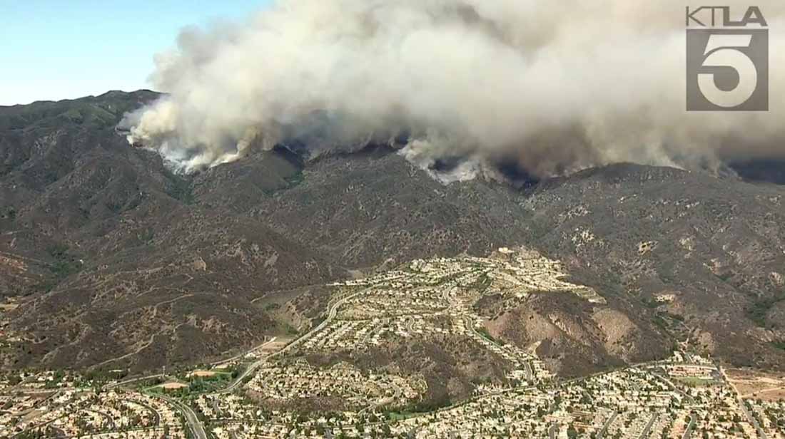
KTLA photo holy fire
Photo by KTLA at approximately 9 a.m. August 8, 2018.

As of very early Wednesday morning fire officials said the fire had burned 4,129 acres, but due to the active fire behavior it could now be significantly larger.

As of 10:51 Wednesday morning the only evacuations orders in effect were for Holy Jim Canyon, Trabuco Canyon recreation residence tracts, and the Blue Jay and Falcon Campgrounds. Areas under voluntary evacuation included Sycamore Creek, McVicker, Rice,  Horsethief, and Glen Eden areas, and along the Ortega Highway west of the Lookout Restaurant.
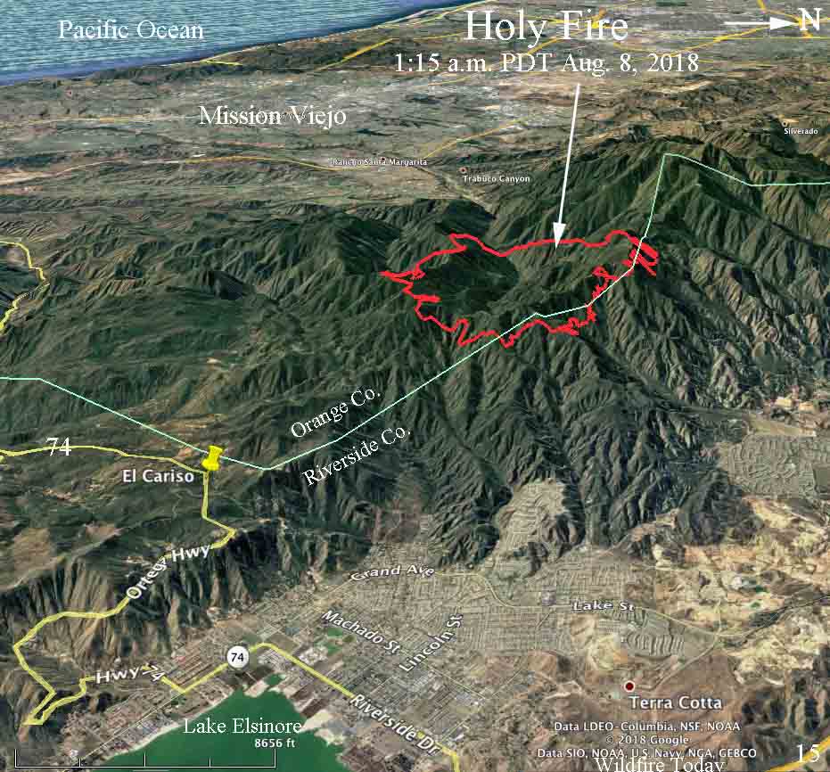
map Holy Fire August 8
3-D map showing the approximate perimeter of the Holy Fire at 1:15 a.m. PDT August 8, 2018 as determined by a fixed wing aircraft. It is likely that by mid-morning on August 8 the fire has progressed farther downhill to the east.

With the other wildfires burning in California the incident management team has not been able to obtain all of the firefighting resources that they believe is needed. They are doing the best they can with what is available. As of Wednesday morning they had: 30 Fire Engines, 10 Helicopters, 7 Fixed Wing aircraft, 3 Dozers, 1 Water Tender, and 12 Hand Crews, for a total of 444 personnel. That are low numbers for the third day of a fire that is threatening many structures.
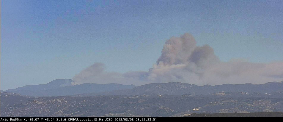
 

Holy Fire photo
The view of the Holy Fire from Red Mountain looking northwest at 8:52 a.m. PDT August 8, 2018. SDG&E camera.

Photos from the Holy Fire

And, a video of the 747 Supertanker dropping

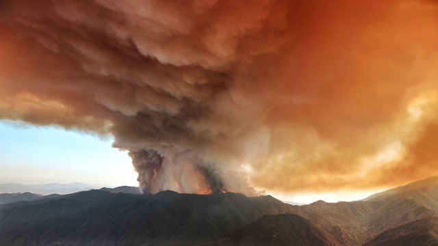
(Above: The Holy Fire as seen from the 747 Supertanker August 6, 2018. Credit: Hiroshi Ando, Drop System Operator, Global SuperTanker)

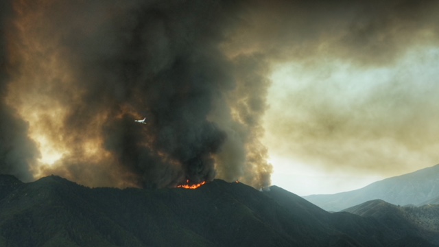
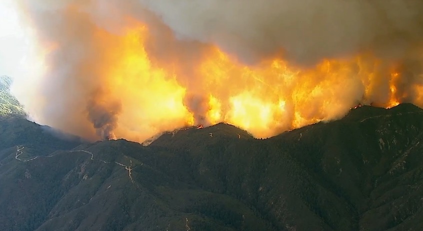
The photo above and the next three photos of the Holy Fire in Orange County, California were taken August 6 from the 747 Supertanker by Hiroshi Ando, Drop System Operator, Global SuperTanker.

Holy Fire Orange County California
The Holy Fire as seen from the 747 Supertanker August 6, 2018. Credit: Hiroshi Ando, Drop System Operator, Global SuperTanker.
Holy Fire Orange County California
The Holy Fire as seen from the 747 Supertanker August 6, 2018. Credit: Hiroshi Ando, Drop System Operator, Global SuperTanker.

(To see all articles about the Holy Fire on Wildfire Today, including the most recent, click HERE.)
Continue reading “Photos from the Holy Fire”

Brush fire burns in Santa Ana Mountains of Southern California

The Holy Fire is in Holy Jim Canyon in Orange County 6 miles northwest of Lake Elsinore, California

Above: the view from the Nevada Seismological Laboratory camera on Santiago Peak looking southeast at 6:52 p.m. PDT August 6, 2018.

(UPDATED at 6:44 a.m. PDT August 7, 2018)

Late Monday night the U.S. Forest Service estimated that the Holy Fire in the Cleveland National Forest east of Rancho Santa Margarita, California had burned approximately 4,000 acres, but that figure could change with more accurate mapping.

The fire started in Trabuco Canyon east of Holy Jim Canyon and rapidly ran up the very steep slopes to the North Main Divide Road at the top of the ridge. The latest rough mapping by the incident management team indicates that very little of the fire has crossed the road which is primarily on the top of the ridge. But better mapping in daylight will provide better information. That road is also near the boundary between Orange and Riverside Counties, and so far most of the blaze is in Orange County.

(To see all articles about the Holy Fire on Wildfire Today, including the most recent, click HERE.)

3-D map Holy Fire August 6 2018
3-D map, looking east, showing the approximate location of the Holy Fire Monday night August 6, 2018. Click to enlarge.

(Originally published at 7:27 p.m. PDT August 6, 2018)

A brush fire in Trabuco Canyon in the Cleveland National Forest in Southern California has burned at least two cabins. The  blaze started around 1:30 p.m. Monday near the intersection of Holy Jim Canyon Road and Trabuco Creek Road. In mid-afternoon fire officials estimated it had burned about 1,200 acres.

Holy Fire
Holy Fire at 5:11 p.m. PDT August 6, 2017. Screen grab from ABC7 video.

It is spreading up very steep slopes in the canyons on the west side of the Santa Ana Mountains, running up to the North Main Divide Road, an elevation change of about 2,600 feet. A Los Angeles TV station, ABC7, has had intermittent live video from a helicopter showing fairly intense fire behavior, with frequent fire whirls on the flaming front.

The fire is two miles east of the community of Trabuco Canyon, three miles southeast of Temescal Valley, and six miles northwest of Lake Elsinore.

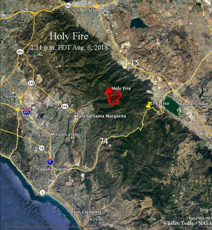
map Holy Fire
Map showing the approximate location of the Holy Fire at 2:11 p.m. PDT August 6, 2018, based on heat detected by a satellite.

Continue reading “Brush fire burns in Santa Ana Mountains of Southern California”

Smokejumpers used on the Holy Fire in southern California

Above: Smokejumpers descend over the Holy Fire August 31, 2016. USFS photo.

(Originally published at 11:08 a.m. PDT September 1, 2016. Updated at 1:44 p.m. PDT September 1, 2016)

Until yesterday smokejumpers had never parachuted into a fire on the Cleveland National Forest. This was the only National Forest in California that had not yet inserted jumpers in this manner. Occasionally jumpers are assigned to a fire but arrive in a conventional manner, on the ground.

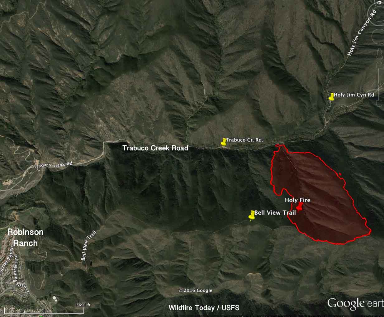
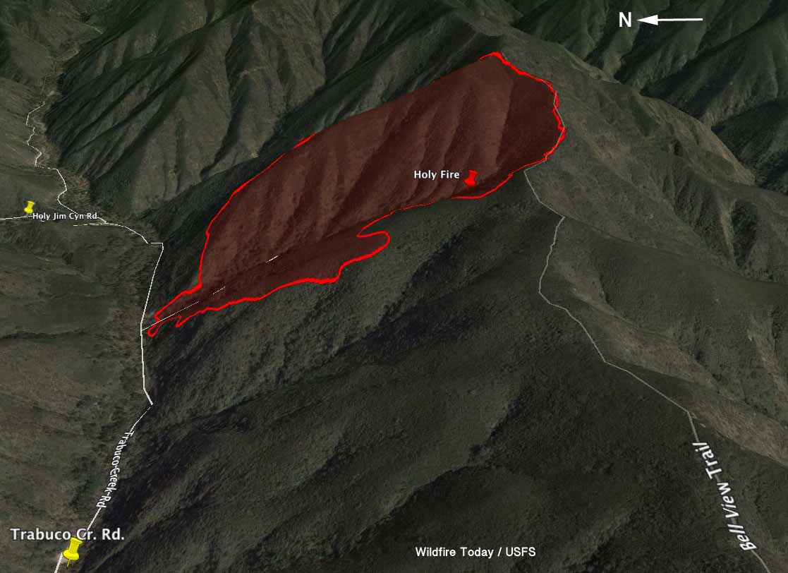
They were ordered for the Holy Fire just off of Trabuco Creek Road 2.2 miles east of the city of Robinson Ranch in Orange County, California. The fire burned 155 acres between the road and the Bell View Trail at the top of the ridge above Trabuco Canyon. The fire ran to the top of the north-facing slope and stopped thanks to the efforts of firefighters on the ground, the change in topography and fuels, and the heavy use of helicopters and air tankers, including a DC-10.

Thursday morning there were 273 personnel assigned to the Holy Fire, which got its name from the nearby Holy Jim Canyon.

Map Holy Fire
Map of the Holy Fire at 8 p.m. PDT August 31, 2016. Click to enlarge.

The Cleveland National Forest stretches between the greater Los Angeles metropolitan area and the outskirts of San Diego.

map Holy fire 3-d
3-D map of the Holy Fire at 8 p.m. PDT August 31, 2016. Click to enlarge.

Jason Foreman with the Redding Smokejumpers said the 16 jumpers were dispatched from Redding and Porterville using a U.S. Forest Service Sherpa and a contract Dornier aircraft, each with 8 firefighters. The arrival of the Dornier out of Porterville was delayed due to the very busy air space in southern California. The jumpers from Porterville landed on the ground at approximately 6:30 p.m. PDT, while the Redding squad all completed their jumps by 7:50 p.m Wednesday, Mr. Foreman said.

“A critical piece of line needed to be secured in an expeditious manner. The terrain to get to the ridgeline was steep and had limited access” Olivia Walker, spokesperson for the Cleveland National Forest said when asked why local firefighters were not used instead of the smokejumpers. “There were no personnel available to staff the section of line that was used to insert the Smokejumpers on”, she explained.

Four firefighters suffered heat-related injuries and were extracted by helicopters. The fire was managed in a unified command with the U.S. Forest Service and the Orange County Fire Authority.

Access to the base of the fire was via Trabuco Creek Road. A 3-mile hike from Robinson Ranch on the Bell Ridge Trail would take you to the top of the fire. The terrain at the fire is very steep. Hikers on the trail would have a 1,500-foot elevation change — up.

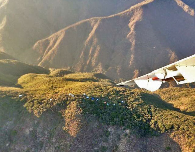
Parachute canopies Holy Fire
Parachute canopies are visible near the Bell View Trail at the Holy Fire. USFS photo.