Wallangarra bushfire burns over 100,000 acres in NSW

It is burning in both Queensland and New South Wales, Australia

Wallangarra bushfire NSW Australia
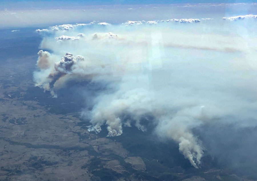
A bushfire in New South Wales and Queensland is near Wallangarra, Tenterfield, Stanthorpe, and Jennings. NSW RFS photo.

A very large bushfire has burned at least 43,800ha (108,232 acres) in Queensland and New South Wales in Australia. Smoke from the fire is affecting Wallangarra, Tenterfield, Stanthorpe, and Jennings.

At 8:55 a.m. local time on February 19 the New South Wales Rural Fire Service reported that the fire continues to burn west of the Bruxner Highway in the Girraween, Bald Rock, Boonoo areas.

Most activity overnight was on the southwest side of the fire near Sunnyside, on the northwestern side of the fire in Girraween National Park (Queensland), north of Wallangarra, and on the southeast side near the Bruxner Highway.

During the night crews conducted backburning operations which increased the fire activity and the production of smoke. This smoke is likely to settle around the areas of Tenterfield, Jennings, Wallangarra and Stanthorpe (QLD), but will begin to clear late Tuesday morning.
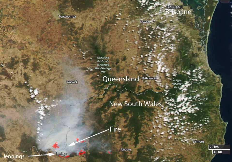
Wallangarra Fire map
Satellite photo of the Wallangarra Fire burning in Queensland and New South Wales. The red dots indicate heat. NASA photo.

Tingha, New South Wales isolated as fire closes roads and burns homes

Tingha Fire map bushfire new south wales
The red dots near Tingha, New South Wales represent heat detected by a satellite. NASA image.

Winds in Australia that have changed directions several times in recent days have been pushing a large bushfire in multiple directions. The Tingha Fire that started Sunday in New South Wales has burned around the community of Tingha closing roads in and out of the community. The blaze is between Inverell and Guyra.

NSW Rural Fire Service Commissioner Shane Fitzsimmons said firefighters indicate “numerous properties” including homes, sheds and other outbuildings were damaged or destroyed Wednesday afternoon.

ABC Australia reported that a 40-year old woman was charged with allowing her trash fire to escape, which ignited what has developed into a 30,600-acre (12,400 ha) wildfire.

The Rural Fire Service said winds on Thursday are expected to push the fire closer to Gilgai. Other areas threatened include Old Mill, Stannifer, Guyra Road east of Tingha, and the Howell Road area. But weather conditions on Thursday should be more favorable for firefighters.

On the map below, Tingha is in the center — where two major roads intersect.

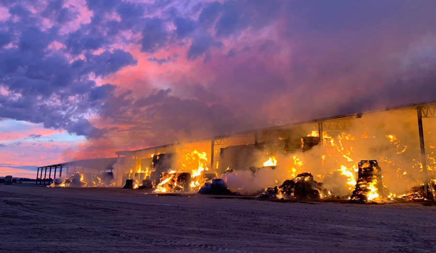
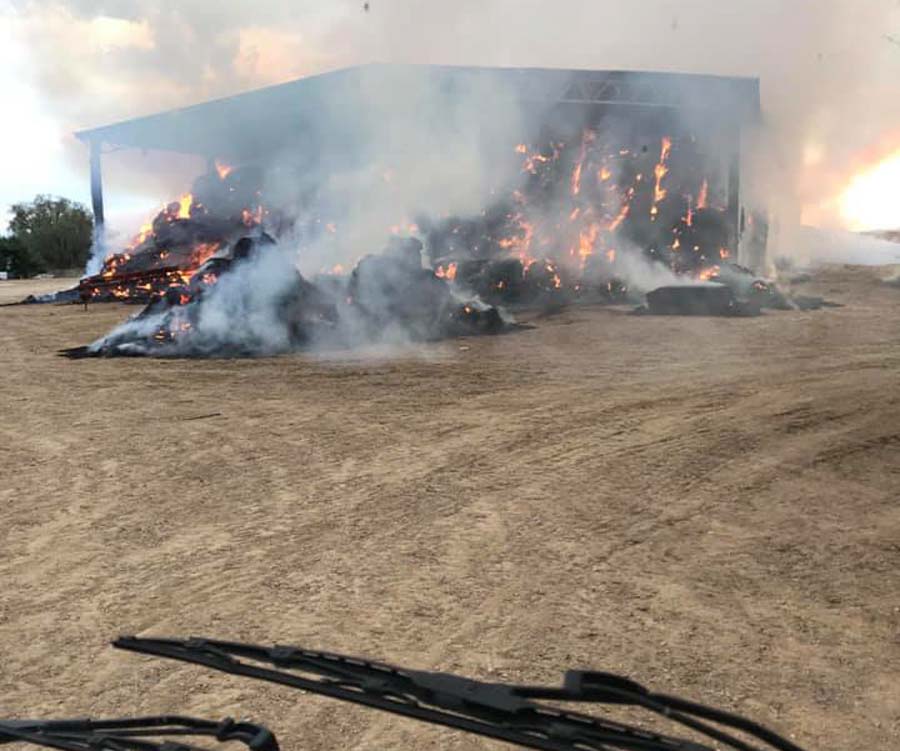
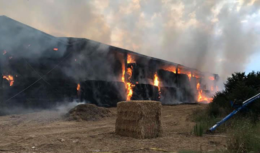
Hay shed fire in New South Wales

hay shed fire new south wales
Photo credit: NSW RFS. Click to enlarge.

On December 12 firefighters from New South Wales Rural Fire Service and Victoria Country Fire Authority responded to a fire in a hay shed on Howlong-Balldale Road northwest of Howlong, NSW.

In a tweet the NSW RFS warned about spontaneous combustion:

With warmer weather the risk of hay stack fires increases. This fire attended by crews between Howlong & Corowa. With hot weather on the way landholders should check the temperature in stored hay & if possible ensure that farm machinery is kept in a separate shed.

hay shed fire new south wales
Photo credit: Fire and Rescue NSW Station 206 Albury North
hay shed fire new south wales
Photo credit: Fire and Rescue NSW Station 206 Albury North

The University of Montana has information about spontaneous combustion in hay:


“Oddly enough, wet hay is more likely to lead to a spontaneous combustion fire than dry hay. If hay is put into a barn or stack when it has more than about 22 percent moisture, not only does the hay loose forage quality, but it has an increased risk of spontaneous combustion.

“High moisture hay stacks can have chemical reactions that build heat. Hay insulates, so the larger the haystack, the less cooling there is to offset the heat.

“When the internal temperature of hay rises above 130 degrees Fahrenheit (55 degrees C), a chemical reaction begins to produce flammable gas that can ignite if the temperature goes high enough.

“Hay fires generally occur within six weeks of baling. Heating occurs in all hay above 15 percent moisture, but generally it peaks at 125 to130 degrees F, within three to seven days, with minimal risk of combustion or forage quality losses. Temperature within a stack then declines to safe levels in the next 15 to 60 days, depending on bale and stack density, ambient temperature and humidity, and rainfall absorbed by the hay.

“To avoid hay fires, small, rectangular bales should not exceed 18 to 22 percent moisture, and large round or rectangular bales should not exceed 16 to 18 percent moisture for safe storage.

“In addition, you should check your hay regularly. If you detect a slight caramel odor or a distinct musty smell, chances are your hay is heating. At this point, checking the moisture is too late, and you’ll need to keep monitoring the hay’s temperature.”

A 737 air tanker used for the first time

On November 22 Air Tanker 137 dropped on a bushfire in New South Wales

tanker 137 Boeing 737 drop first wildfire bushfire
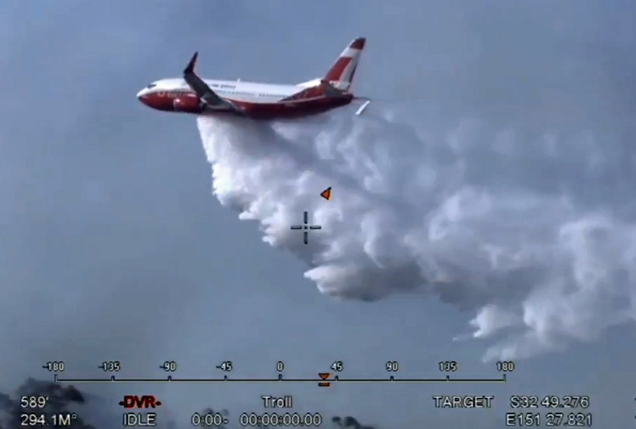
On November 22 Air Tanker 137 made the first drop by a Boeing 737 on an active fire. It occurred in the Hunter region of New South Wales, Australia. Screenshot from NSW RFS video.

(This article was first published on Fire Aviation)

On November 22 Air Tanker 137 made the first drop by a Boeing 737 on an active fire. It occurred in the Hunter region of New South Wales, Australia.

Coulson completed the conversion of the 737 a few months ago and it is now working on a contract with the New South Wales Rural Fire Service during their summer. Nicknamed “Gaia”, it arrived at Richmond RAAF Base near Sydney November 11 after a multi-day trip across the equator. It will be primarily based at the RAAF Base along with three other large air tankers from North America — a C-130Q (T-134), and two RJ85s (T-165 and T-166). Two other large air tankers will be based in Victoria at Avalon Airport in Melbourne, a C-130Q (T-131), and an RJ85 (T-163).

Going by the coordinates on the images, the fire T-137 dropped on was very close to the Kurri Kurri Hospital southwest of Heddon Greta. The NSW RFS reported at 8:14 p.m. local time on November 22 that firefighters assisted by aircraft had slowed the spread of the fire. They estimated it had burned 61 hectares (151 acres).

bushfire Kurri Kurri Hospital NSW
The coordinates indicate the approximate location of the drop by Tanker 137. Google Earth.
tanker 137 Boeing 737 drop first wildfire bushfire
On November 22 Air Tanker 137 made the first drop by a Boeing 737 on an active fire. It occurred in the Hunter region of New South Wales, Australia. Screenshot from NSW RFS video. Click to enlarge.

Burn scars of the fire that burned into Tathra, NSW

(Originally published at 3:26 MDT March 27, 2018)

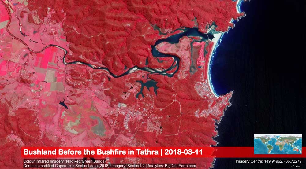
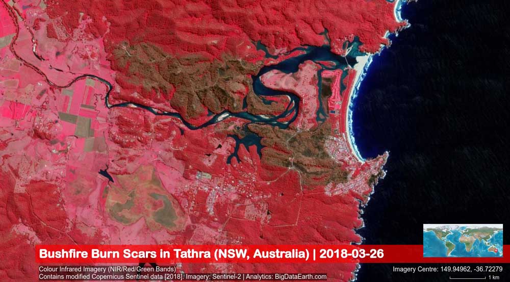
These satellite images show before and after photos of the March 18, 2018 bushfire that started southeast of Bega, NSW, Australia, and burned into Tathra, destroying at last count 69 homes.

The images were captured by the Sentinel-2 satellite system (March 26, 2018, 11:02 am local time) and were analyzed by BigDataEarth.com.

map tathra NSW wildfire homes destroyed
Map showing the area in New South Wales between Bega (on the left) and Tathra (on the coast on the right) before the fire.
map tathra New South Wales wildfire
Map showing the area in New South Wales between Bega (on the left) and Tathra (on the coast on the right) after the fire. The brown areas represent the burned area.