Large fire burns much of the northern half of Fraser Island in Queensland

The blaze is about 46 miles long

map fire Fraser Island Queensland Australia
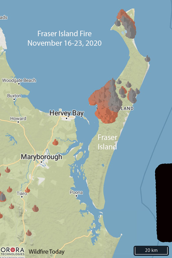
Map showing heat detected by satellites at the fire on Fraser Island in Queensland, during the period November 16 through 23, 2020. The large gap shown between the burned areas is because the satellite heat data between October 14 and November 15, 2020 was not available.

A large wildfire is burning on Fraser Island off the coast of Queensland, Australia. Since it started October 14 it has grown to 46 miles in length, north to south, covering much of the 76-mile long island.

Officials from the Queensland Fire and Emergency Services (QFES) believe it started from an illegal cooking fire that was not completely extinguished.
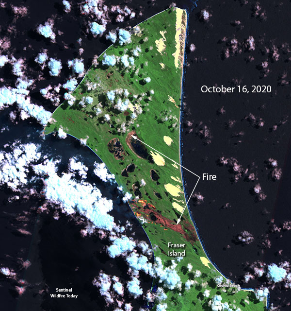
Satellite photo showing the fire on Fraser Island in Queensland, October 16, 2020
Satellite photo showing the fire on Fraser Island in Queensland, October 16, 2020 a few days after it was reported.
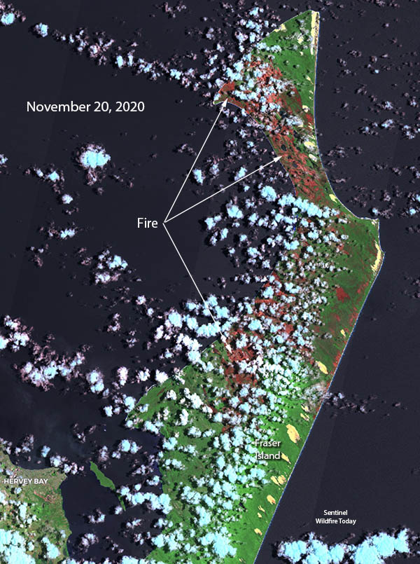
Satellite photo showing the fire on Fraser Island
Satellite photo showing the fire on Fraser Island in Queensland, November 20, 2020.

At of 2:15 p.m. Sunday November 22, the QFES reported the fire was north of Moon Point Road East, and was west of Northern Road.

Crews from the QFES are assisting Parks and Wildlife rangers working to contain the blaze with the use of back burns, assisted by Conair’s Q400 air tanker which has been dropping on the fire, reloading at Bundaberg.

No homes or private property were directly threatened as of November 20.

Judging from the satellite data, the fire appeared to burn in a mosaic pattern, leaving unburned areas scattered throughout the fire’s footprint.

Fraser Island, a World Heritage-listed national park, is the world’s largest sand island (covering 410,000 acres), with rainforests, pristine freshwater lakes, seafront rock pools, colored sand cliffs, massive dunes and more than 75 miles of unspoiled beachfront facing the Pacific Ocean.

Rain stops some of the bushfires in Australia

A number of locations have received 100 mm (almost four inches) of precipitation

Precip Observed
Observed precipitation observed during the seven-day period ending February 7. The darkest green color indicates 100 mm (almost 4 inches) of precipitation.

Many areas in New South Wales, Victoria, and Queensland have received multiple inches of rain over the last seven days with a number of locations recording about 100 mm (almost four inches).

A heavy rain could come close to putting out some fires but a light rain, depending on the fuel (vegetation), might just pause the spread for a while. And some regions have received little or no rain.

NSW Rural Fire Service commissioner Shane Fitzsimmons says the rain is “breaking the back” of the bushfire season. “The rain is good for business and farms as well as being really good for quenching some of these fires we’ve been dealing with for many, many months,” the commissioner told ABC TV on Friday.

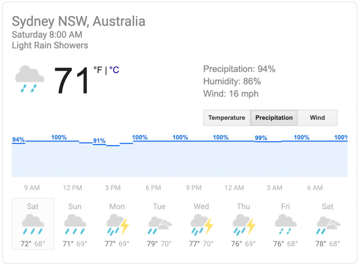
The forecast for Sydney, on the NSW coast, calls for nearly 100 percent chance of precipitation every day over the next eight days.

Precipitation forecast for Sydney, Australia
Precipitation forecast for Sydney, Australia. Generated Saturday February 8 local time.

Wallangarra bushfire burns over 100,000 acres in NSW

It is burning in both Queensland and New South Wales, Australia

Wallangarra bushfire NSW Australia
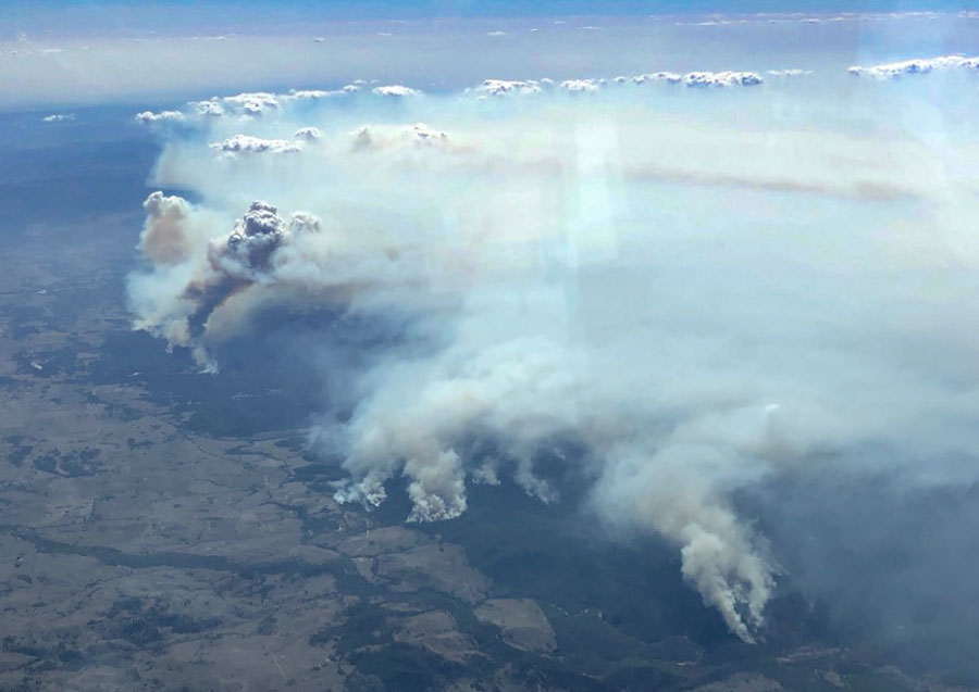
A bushfire in New South Wales and Queensland is near Wallangarra, Tenterfield, Stanthorpe, and Jennings. NSW RFS photo.

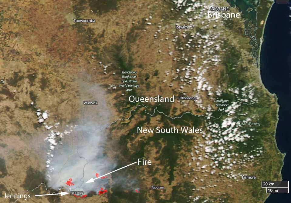
A very large bushfire has burned at least 43,800ha (108,232 acres) in Queensland and New South Wales in Australia. Smoke from the fire is affecting Wallangarra, Tenterfield, Stanthorpe, and Jennings.

At 8:55 a.m. local time on February 19 the New South Wales Rural Fire Service reported that the fire continues to burn west of the Bruxner Highway in the Girraween, Bald Rock, Boonoo areas.

Most activity overnight was on the southwest side of the fire near Sunnyside, on the northwestern side of the fire in Girraween National Park (Queensland), north of Wallangarra, and on the southeast side near the Bruxner Highway.

During the night crews conducted backburning operations which increased the fire activity and the production of smoke. This smoke is likely to settle around the areas of Tenterfield, Jennings, Wallangarra and Stanthorpe (QLD), but will begin to clear late Tuesday morning.

Wallangarra Fire map
Satellite photo of the Wallangarra Fire burning in Queensland and New South Wales. The red dots indicate heat. NASA photo.

Little improvement seen in wildfire situation in Queensland

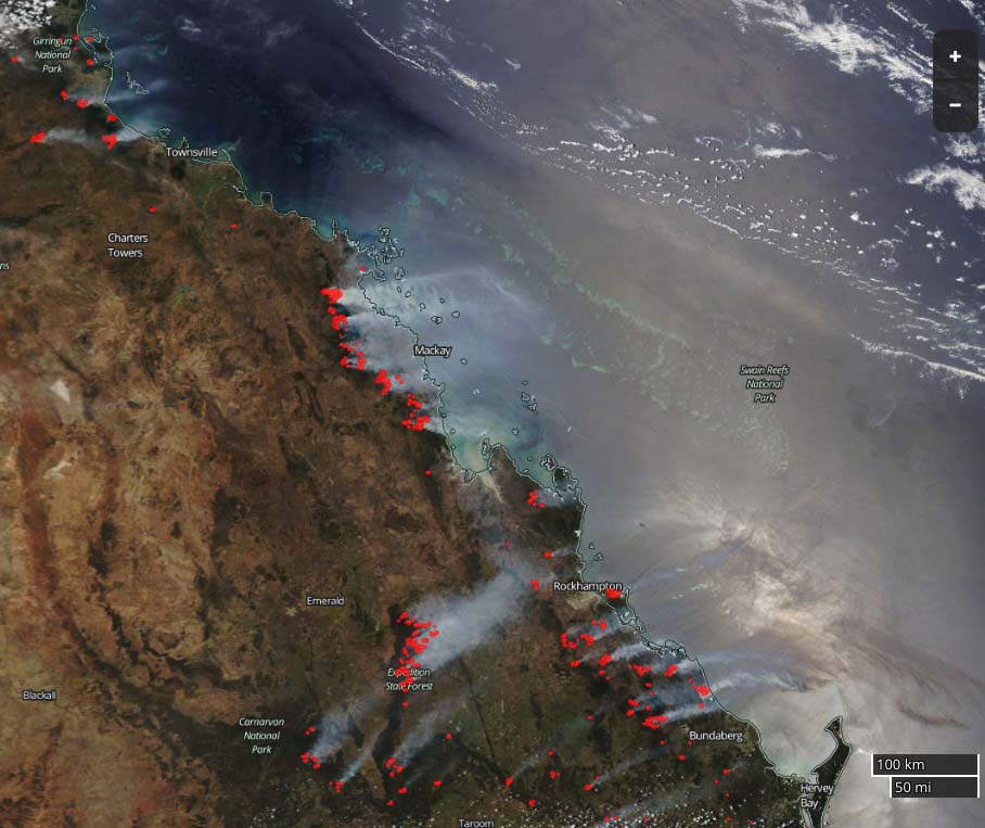
map wildfires in Queensland, Australia
Satellite photo showing smoke from wildfires in Queensland, Australia November 29, 2018. NASA

Firefighters in Queensland are expecting another five days of exceptionally hot and dry weather. There are 130 fires currently burning, with about seven of them described as fast moving and significant.

Hundreds of firefighters have arrived from New South Wales and other areas to lend a hand.

An evacuation order remains in place for Deepwater, while a number of areas including Dalrymple Heights, Winfield, Carmila and Captain Creek are being urged to “stay informed”.

Record temperatures are forecast for Longreach in excess of 45 C (113 F) in the coming days before the heatwave is expected to move down to the southeast next week.

The premier of Queensland, Annastacia Palaszczuk, has been monitoring the situation closely and is helping to spread important information to the residents of her state.

Queensland experiences “catastrophic” wildfire danger for the first time

Deepwater Fire Queensland
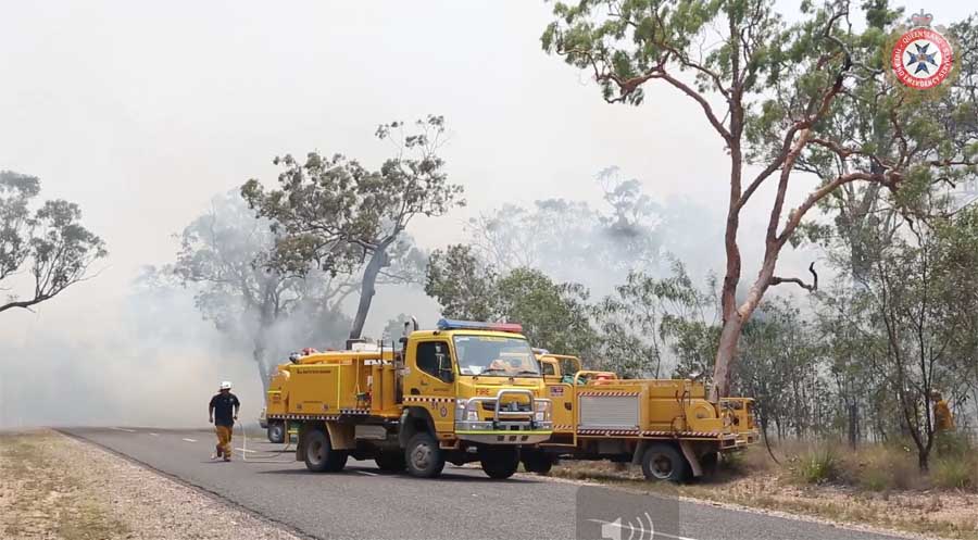
Firefighters battle the wildfire near Deepwater in Queensland. F&ES photo.

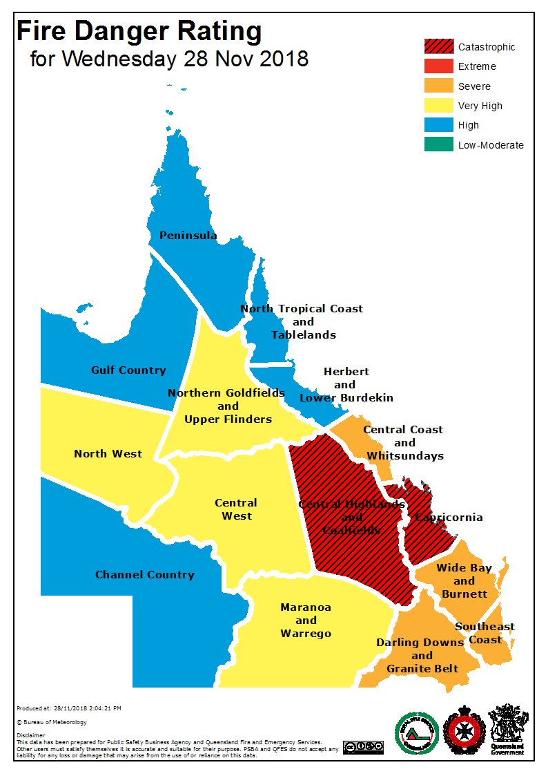
Firefighters and residents of Queensland in northeast Australia are figuring out how to deal with unprecedented conditions — 135 wildfires all burning at the same time during very hot, windy conditions. Fire officials have elevated the fire danger to a level previously unseen in the state, “catastrophic”. Evacuations are underway in several communities.

Queensland fire danger
The Queensland Bureau of Meteorology wrote in their tweet with this image: “Fire ? Danger Ratings have reached Catastrophic for the first time in #Queensland due to the combination of a very dry, hot airmass and strong, gusty westerly winds. Follow the advice of @QldFES during these extremely challenging fire weather conditions.

This is supposed to be the wet season in Queensland.

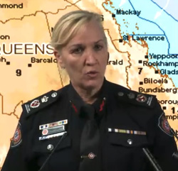
Katarin Carroll, Commissioner of Queensland F&ES
Katarin Carroll, Commissioner of Queensland F&ES at briefing November 26, 2018.

In a public briefing Wednesday evening, Katarin Carroll, Commissioner of Queensland Fire and Emergency Services, said they saw this coming and began ordering additional firefighting resources from New South Wales and other states last week. The forecast calls for the extraordinarily hot and dry weather to continue in Queensland through Tuesday, December 4. Meanwhile farther south, New South Wales is receiving large quantities of rain, causing flooding in some areas.

This is normally the dry season in NSW.

In the video below Annastacia Palaszczuk, Premier of Queensland, begins the November 26 evening briefing about the fire situation, followed by Commissioner Carroll.

Wildfires are affecting a number of areas in Queensland, including Campwin Beach, Sarina Beach, Deepwater, Baffle Creek, Rules Beach, Oyster Creek, Caloundra, Gracemere, Eungella, and Kowari Gorge.

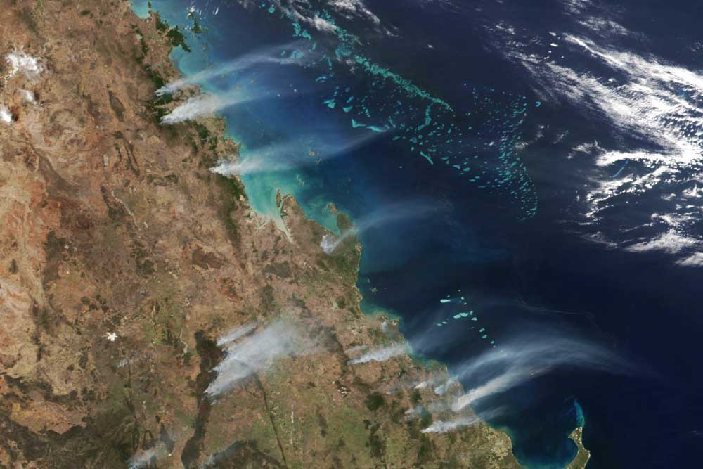
Fires Queensland satellite photo
Satellite photo of smoke from the fires in Queensland, Australia, November 26, 2018. Since then clouds have made it difficult to obtain a good image of the area. NASA