Extreme fire weather predicted for areas in New Mexico and Texas

Strong winds and low RH

Warnings February 20 and 21, 2022. NWS.
Red Flag Warnings and Fire Weather Watches, February 20, 2022. NWS.

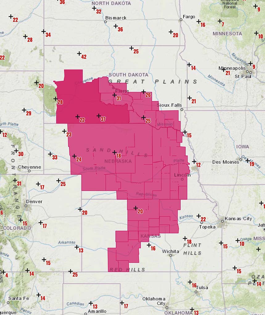
The National Weather Service has issued a Red Flag Warning in effect Sunday for an area in the East Central Plains in Eastern New Mexico. The forecast calls for 8 to 13 percent relative humidity and 15 to 30 mph winds gusting out of the west at 40 mph.

Similar conditions are predicted for Monday in Southeast New Mexico and Eastern Texas where a Fire Weather Watch is in the forecast for 10 percent relative humidity and southwest winds of 15 to 25 mph gusting to 35. It is likely the Watch will be upgraded to a Red Flag Warning on Monday.

The Hot-Dry-Windy Index for Western Texas shows the fire danger increasing Sunday and Monday, reaching above the 75th or 90th percentiles Monday.

HDW Index, Western Texas fire danger
HDW Index, Western Texas, created FEb. 20, 2022.

Red Flag Warning in seven states, Feb. 14

Wildfire in Mississippi burned more than 1,000 acres

Red Flag Warnings, Feb. 14, 2022 fire wildfire
Red Flag Warnings issued by the NWS, Feb. 14, 2022.

The National Weather Service has issued Red Flag Warnings for Monday February 14 for areas in New Mexico, Kansas, Missouri, Arkansas, Louisiana, Mississippi, and Florida.

It is not common to see Red Flag Warnings in Arkansas, Louisiana, Mississippi. Take a look at the video below  posted today of a fire in northeast Mississippi that burned 1,041 acres; it’s a very interesting burn pattern.

I checked with Tyler Thomas who is an Area Forester for the Mississippi Forestry Commission (MFC) who told us the fire occurred January 31 and February 1. In addition to the personnel from local fire departments, the MFC had five firefighters on it which included two dozers with swampers. When they arrived it had already burned about 1,000 acres and when the spread was stopped it was about three miles long.

I mentioned to Mr. Thomas what looked like in the aircraft video an unusual burn pattern, but he said it was all one fire and there was no major spotting out ahead of the main fire.


UPDATE Feb 19, 2022: The map below shows the estimated perimeter of the fire in NE Mississippi, based on imagery. The fire was named, 1686 County Road 202 Fire.

Fire in NE Mississippi
Fire in NE Mississippi, estimated perimeter Feb. 1, 2022.

Red Flag Warning in the Plains Tuesday

Low relative humidity and strong winds

Red Flag warnings, Central Plains
Red Flag warnings, Central Plains. Map shows wind gusts at 10:45 a.m. CST Feb. 8, 2022. NWS.

A Red Flag Warning is in effect February 8 for low humidity and strong winds in parts of the Central Plains Tuesday, affecting areas in South Dakota, Nebraska, and Kansas. The warnings expire around sunset.

The forecast from the National Weather Service calls for increasing winds in the morning, tapering off in the late afternoon:

  • South Dakota: 20 to 25 percent RH with 20 to 45 mph winds gusting at 50 to 65 mph.
  • Nebraska: 15 to 25 percent RH with 20 to 30 mph winds gusting to 45 mph.
  • Kansas: 17 percent RH with 20 to 25 mph winds gusting to 40 mph.

Red Flag Warnings Wednesday for parts of eight states

Portions of Colorado, Kansas, Nebraska, New Mexico, Iowa, Missouri, Texas, and Oklahoma

UPDATED at 9:08 a.m. MST Dec. 15, 2021


Originally published at 7:33 p.m. MST Dec. 14, 2021

 Flag Warnings Dec. 15, 2021
Red Flag Warnings Dec. 15, 2021. NWS / Google.

Critical fire weather on Wednesday December 15 has now been confirmed for eastern Colorado, most of Kansas, southeast Nebraska, eastern New Mexico, southwest Iowa, northwest Missouri, and the panhandles of Texas and Oklahoma.

Red Flag Warnings issued by the National Weather Service Tuesday predict very strong west or southwest winds 30 to 45 mph with gusts to 60 or 80 depending on the location and relative humidity in the low teens. Red Flag Warnings will expire Wednesday evening.

With the area experiencing levels of drought ranging from moderate to extreme, the fuels are dry and could be easily ignited. Vegetation fires could spread very rapidly and be difficult to suppress.

Critical fire weather predicted Wednesday for parts of OK, CO, KS, and TX

Low humidity with wind gusts above 65 mph

Fire Weather Watch
Fire Weather Watch issued Dec. 13 for Wednesday Dec. 15, 2021. NWS & Google.

Critical fire weather is in the forecast Wednesday for southeast Colorado, western Kansas, and the panhandles of Texas and Oklahoma. A Fire Weather Watch issued by the National Weather Service Monday morning predicts strong southwest winds Wednesday 35 to 45 mph with gusts to 65 and relative humidity in the low teens. Red Flag Warnings will probably be issued for Wednesday.

With the area experiencing levels of drought ranging from moderate to extreme, the fuels are dry and could be easily ignited.

Drought Monitor, Dec. 7, 2021.

Since December 7 the Energy Release Component (ERC) for the Texas panhandle has been setting new daily records for the highest ever recorded for those dates. On December 12 it was 72 while the average for this time of the year is in the low 40s. The ERC can help predict the intensity and rate of spread of a wildland fire. It is expected to remain in record-setting territory through at least December 19.

Energy Release Component for the Texas Panhandle
Energy Release Component for the Texas Panhandle, generated Dec. 13, 2021.

The Texas Forest Service has arranged for two large air tankers to be in the area to “support suppression efforts in Oklahoma and Texas as requested”. They are opening the Air Tanker base at Abilene.

Wind gusts over 60 mph lead to preemptive power shutoffs in Southern California on Thanksgiving

Red Flag warnings in effect

10:30 a.m. PST Nov. 25, 2021

Wind gusts 50+ mph, 938 a.m. PST Nov. 25, 2021. California.
Wind gusts 50+ mph, 9:38 a.m. PST Nov. 25, 2021. California.

Red Flag Warnings and wind gusts of 50 to 69 mph have led to preemptive power shutoffs in Southern California on Thanksgiving day.

Southern California Edison reported at 10:25 a.m. Thursday that 1.1 percent, or 63,835 of their customers, have had their electrical power turned off as a preemptive measure to prevent wildfires if the strong winds blow down power lines. An additional 156,000 customers are in areas where power shutoffs are under consideration.

At 9:38 a.m. Thursday 44 weather stations had wind gusts that exceeded 50 mph, with the highest being 69 mph at Cloudland Cutoff. At that time 380 stations recorded conditions meeting Red Flag Warning criteria, and another 307 were flirting with the status. Most had relative humidity in the low teens.

The strong winds out of the northeast are expected to decrease Thursday afternoon and by 8 p.m. will be less than 7 mph in most areas. But the extremely low relative humidity in the single digits or teens will continue through Monday.

As this is being written at 10:30 a.m. PST Thursday there have been no reports of large fires during this wind event.

Red Flag Warnings, Southern California
Red Flag Warnings, Southern California, Nov. 25, 2021