The Rapid City office of the National Weather Service acquired these satellites photos of the Schroeder Fire which has burned 2,195 acres just west of their city.
Here is how they described the photos in a Tweet Thursday evening:
“Sentinel-2 satellite views of Schroeder Fire on Mar. 29 (when it started) and today (Apr. 1). The red hot spots are not apparent today, and the reddish-brown area shows the extent of the fire. White = clouds in first image (black = shadows). Green = vegetation.”
The NWS office in Rapid City is on a hill about four miles due east of the Schroeder Fire. They probably had an excellent view of the fire, if the smoke permitted.
You can follow the Rapid City NWS on Twitter: @NWSRapidCity
The Schroeder Fire at Rapid City has burned 2,165 acres
Updated 8:01 a.m. MDT April 1, 2021
Schroeder Fire, March 31, 2021. Incident Management Team photo.
Mount Rushmore National Memorial opened for visitors at 5 a.m. Thursday, April 1. The 244 Fire within the Memorial has been more accurately mapped at 136 acres. Sixty firefighters from federal, state, and local government are working to secure containment lines, mop up hot spots, and remove hazardous snags from along roadways.
The Black Hills area is under a Red Flag Warning Thursday for winds gusting up to 35 mph and relative humidity in the low teens.
The Schroeder Fire grew by 30 acres Wednesday as firefighters conducted burnout operations to improve fire lines by removing unburned fuel between the lines and the main body of the fire. This slightly increased the fire’s size to 2,195 acres. Approximately 250 personnel are assigned to the fire.
Originally published at 9:50 a.m. MDT March 31, 2021
244 Fire at Mount Rushmore, March 30, 2021. NPS photo.
Firefighters have made progress on the three wildfires in the Black Hills of South Dakota.
Schroeder Fire
The largest is the Schroeder Fire just west of Rapid City. It was mapped from an aircraft at 4:30 p.m. on Tuesday and was found to have grown to 2,165 acres, an increase of about 260 acres. At that time it had not crossed Highway 44 or South Canyon Road and fire authorities are optimistic that they can keep it between the two roads.
The satellite overflights Tuesday night did not detect any very large heat sources on any of the three fires, but there are likely many locations on the blazes where heavy fuel is still burning or could even be slowly spreading through light fuels. Fire personnel will no doubt be mopping up for several more days, extinguishing logs and deep-seated heat.
Map of the Schroeder Fire. Data from 4:30 p.m. MDT March 30, 2021.
Most of the Schroeder Fire has burned in the footprint of the Westberry Trails Fire of 1988.
Map showing the locations of the Westberry Trails Fire of 1988 and the Schroeder Fire which was mapped March 30, 2021.
244 Fire
The 244 Fire is named after the highway that leads to Mount Rushmore National Memorial. Most of the fire’s 90 acres are within the boundary of the 1,200-acre Memorial, with the rest being in the Black Hills National Forest. The National Park Service said the Memorial is still closed today, March 31. There has been no announcement about when it will reopen.
Very little information has been released about the 244 Fire, but the last update at noon on Tuesday said the head of the fire was active, but generally it was “creeping”, moving very slowly.
Black Hills vulnerable to wildfires
Two hours after the Schroeder Fire was reported, the relative humidity increased from 16% to 50% and the temperature dropped 22 degrees, from 68 to 46 degrees. If that had not occurred it is likely that the three fires would have grown much larger, pushed by the very strong winds.
These wildfires occurring on the same day are an example of how vulnerable the Black Hills and the Mount Rushmore area are to fires, a fact often pointed out to advocates of exploding fireworks at the Memorial.
244 Fire at Mount Rushmore. Mapped by Colorado’s MultiMission Aircraft March 29, 2021. Supplied by the Incident Management Team.Map of the 244 Fire and the Keystone Fire, showing heat detected by satellites during the 24-hour period ending at 2:30 a.m. MDT, March 30, 2021. Wildfire Today and NASA.
Keystone Fire
The last update on the Keystone Fire, at 6:30 p.m. March 30, said personnel were “working to get a line around” the 9-acre blaze which is near Keystone. There were plans to have hand crews working on the fire on March 31.
Schroeder Fire, March 30, 2021. Photo by Incident Management Team.
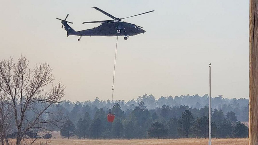
One of the South Dakota National Guard HH-60M Blackhawk helicopters working the Schroeder Fire at Rapid City, March 29, 2021. Photo via Pennington Co Sheriff.
This article was first published at FireAviation.com
4:44 p.m. MDT, March 30, 2021
On Tuesday, the day after the 1,900-acre Schroder Fire broke out just west of Rapid City, South Dakota, two large air tankers were relocated to the tanker base at the airport.
File photo of Air Tanker 167, an RJ85, at Medford Oregon September 9, 2019. Photo by Tim Crippin.
Tanker 105, an MD-87, flew in from New Mexico, and Tanker 167, an RJ85 arrived from Minnesota.
Each of the tankers had made at least two drops on the fire as of mid-afternoon Tuesday.
File photo of Tanker 105 (foreground), an MD-87 operated by Erickson Aero Tanker (N295EA), and Tanker 10, a BAe-146 (N472NA) operated by Neptune Aviation, working the Bighorm Fire near Tucson, June, 2020. Ned Harris photo.
Other aircraft working the fire today include a fixed wing aerial supervision module, two National Guard Helicopters, and a PC12 intelligence gathering aircraft owned and operated by the state of Colorado.
Fire officials said Tuesday afternoon there were no additional closures or evacuations, and residents along Cavern Road could return to their homes. Since Highway 44 is still closed from Rapid City, the local residents will need to access the area from Johnson Siding.
With some active fire still in the area, there is an expectation that the current road and neighborhood closures will continue through Tuesday night.
There has been no update on the size of the fire since it was mapped at 1,900 acres Monday evening.
The number of destroyed homes remains at one, and that resident on Blue Sky Road has been notified. At least two outbuildings have burned, as well as a deck on a residence.
The elevated fire danger and the passage of the cold front with 50 mph+ winds which caused the fire to spread very rapidly was predicted two days before the fire started on Monday.
Weather forecast two days before the Schroeder Fire
The wind was too strong for any aircraft to be used safely or effectively Monday, so if the aircraft had been proactively prepositioned on Sunday they probably would have been grounded on Monday when the fire was reported that morning. One person we talked to on Tuesday who was not authorized to speak for the firefighting agencies about the air tankers said, “Yesterday the winds were too high. No one wanted to come to South Dakota.” However there was a report that a National Guard Blackhawk based in Rapid City made some marginally effective drops late in the day on Monday after the wind speeds decreased.
If you are a weather geek, you will be fascinated by the data captured as the cold front moved into the Schroeder Fire area on Monday, March 29. The fire was reported at 9:22 a.m. MDT Monday.
One hour temperature drop of 20 degrees in Rapid City with the FROPA. Winds not helping with the Schroeder #wildfire impacting the west side of town #sdwxpic.twitter.com/9MwHpGrf9l
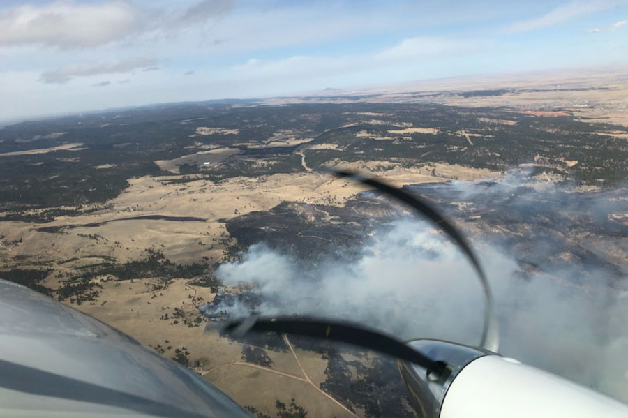
Schroeder Fire as seen from an air attack or lead plane aircraft, March 29, 2021. @PennCoFire photo. The distortion of the propellers is caused by the rolling shutter that is used in most cell phones.Schroeder Fire as seen from Rapid City, March 29, 2021. @PennCoFire photo
In a late night update fire officials said one home and two outbuildings are confirmed to have been destroyed by the Schroeder Fire west of Rapid City, SD.
Firefighters are working during the night in the Cleghorn Canyon, Nameless Cave, and Blessed Sacrament Church areas where they are patrolling and securing structures, in addition to the rest of the fire perimeter.
Updated at 9:22 p.m. MDT March 29, 2021
Map of Schroeder Fire, from a mapping flight at 7:30 p.m. March 29, 2020. Map provided by Schroeder Fire Information.
The Schroeder Fire just west of Rapid City, South Dakota was mapped at 1,905 acres at about 7:30 p.m. MDT March 29.
Fire officials said the blaze was reported Monday at 9:22 a.m. in the Schroeder Road subdivision, skipped across the canyon into the Westberry Trials subdivision and the footprint of the Westberry Trails Fire of 1988 .
A cold front with very strong winds came through around noon and pushed the fire south into the neighborhoods of Cleghorn Canyon, Nameless Cave, and Pinedale Heights.
Incident Commander Rob Powell said Monday afternoon that he was optimistic that they can keep the Schroeder Fire from crossing Highway 44.
The fire is human-caused and still under investigation, but that simply means it was not caused by lightning. Firefighters will staff the fire overnight. Suppression of the fire is a state responsibility, rather than federal.
“We are at record-dry conditions along with high winds playing a major factor in this fight,” said Jay Esperance, Division Director for South Dakota Wildland Fire.
Helicopters and a fixed wing air tanker have been ordered and will be used as needed when weather conditions allow. They can’t be used safely or effectively during strong winds, but a National Guard helicopter was used Monday afternoon after the wind speeds decreased. The Rapid City Air Tanker Base has been activated.
Originally published at 7:25 p.m. MDT March 29, 2021.
Map showing wildfires in the Black Hills, data from 2:36 p.m. MDT March 29, 2021.
At least three wildfires broke out Monday in the Black Hills of South Dakota. (see the map above)
The largest is the Schroeder Fire just west of Rapid City. Heat detected by a satellite at 2:36 p.m. MDT on Monday showed it to be at least 1,000 acres and primarily between Highway 44 and South Canyon Road. Evacuations are in effect. Officials said between 400 and 500 homes have been evacuated in Rapid City and one home and two outbuildings have been destroyed. A map showing evacuation areas is available at the Pennington County website. Suppression of the fire is a state responsibility, rather than federal.
Schroeder Fire map, data from 2:36 p.m. MDT March 29, 2021
At 2:36 p.m. Monday, another fire, the 244 Fire, was less than a mile northeast of Mount Rushmore National Memorial and about a mile southwest of Keystone. It has burned 75 to 100 acres and the Memorial is closed. Suppression of the fire is a federal responsibility, rather than state.
A third blaze, the 15-acre Keystone Fire, is about 1.5 miles south of Keystone. It is being suppressed by the state.
Highway 244 is closed at the west boundary of the Memorial, and the Highway 16A entrance is closed at the Keystone and Iron Mountain Boundary.
The fires were driven by low humidity and very strong winds out of the west at 18 to 35 mph. Gusts above 50 mph were recorded at the weather station at Mount Rushmore.
We will update this article as more information becomes available.
A firefighter conducts a burnout on the 244 Fire near Mount Rushmore in the Black Hills, March 29, 2021. Photo courtesy of Great Plains fire information.The 244 Fire in the Black Hills near Mount Rushmore, March 29, 2021. Photo courtesy of Great Plains fire information.