After a fire, before a flood: NASA’s Landsat directs restoration to at-risk areas

While the 138,000-acre Silver Fire in New Mexico still smoldered, forest restoration specialists were on the job in August. They analyzed maps created using Landsat satellite data to determine where the burn destroyed vegetation and exposed soil – and where to focus emergency restoration efforts.

Silver Fire burn severity
The soil burn severity map of the New Mexico Silver Fire shows areas that with high (red), medium (yellow) and low (green) severity burns. Image Credit: USDA Forest Service, Burned Area Emergency Response Team

“The map looked like a big red blob,” said Penny Luehring, the U.S. Forest Service’s Burned Area Emergency Response and watershed improvement program leader, based in Albuquerque, N.M.

Red means high-severity fire, she explained – and the red areas were concentrated in a watershed drainage that fed communities west of Las Cruces, N.M. So crews got to work. The Burned Area Emergency Response, or BAER, teams are designed to go in as soon as the flames die down to help protect reservoirs, watersheds and infrastructure from post-fire floods and erosion. And Landsat satellites, built by NASA and operated by the U.S. Geological Survey, help direct the crews to those forest areas needing attention.

As a wildfire starts to die down, fire managers like Luehring can contact the Forest Service’s Remote Sensing Applications Center in Salt Lake City to request maps that identify the high, moderate and low severity burns. When that call comes in, remote sensing specialist Carl Albury finds satellite imagery of the burned forest both pre- and post-fire.

In Landsat images, he looks at two of the 11 spectral bands – the near-infrared band and a short-wave infrared band.

“The near infrared reflects well from healthy vegetation, and the short-wave infrared bands reflect well from exposed ground,” Albury said. “By comparing the normalized ratio of the near- and shortwave-infrared bands in the pre-fire image to the post-fire image, we can estimate the burn severity.”
Continue reading “After a fire, before a flood: NASA’s Landsat directs restoration to at-risk areas”

Wildfire briefing, August 9, 2013

Fire photos

We found two very impressive photos of smoke columns, on Instagram, here and here, plus a third one on Facebook.

A “row” over death benefits for families of Granite Mountain 19

As the UK-based Reuters news service reported, there is a “row” over the variable benefits that the Prescott Fire Department intends to give to the families of the 19 members of their department that were killed on the Yarnell Hill Fire. The families of the six firefighters classified as full-time will receive additional financial benefits and lifetime health insurance from the city — much more than the 13 firefighters the department puts in the seasonal category.

Arizona House Speaker Andy Tobin is considering calling for a special session of the state legislature to debate a bill that would ensure that firefighters’ families, at least in this case, are fairly compensated when there are fatalities on state-protected land.

A video at Arizona Central describes the tense relationship between the families of the Granite Mountain 19 and the City of Prescott.

If you have not seen them yet, you need to view the video interviews with survivor Brendan McDonough that we posted earlier today.

Preparedness Level raised to 4

Today the National Interagency Fire Center raised the national Preparedness Level to 4, the criteria for which is:

Three or more Geographic Areas are experiencing incidents requiring Type 1 and 2 IMTs. Competition exists between Geographic Areas. Nationally, 60 percent of Type 1 and 2 IMTs and crews are committed.

Today, August 9, is later than last year for moving into PL 4. In 2012 we transitioned into PL 4 on June 27 and again on August 8.

Incident Management Team assigned to Elk Fire

Rich Harvey’s Type 1 Incident Management Team is mobilizing today to the Elk Fire on the Boise National Forest near Pine, Idaho. This morning there were four other Type 1 IMTeams and one NIMO team assigned to the following fires (Incident Commander’s name/Fire name):

  • Schulte/Big Windy Complex in Oregon
  • Kaslin/Silver Fire in California
  • Houseman (NIMO)/Lodgepole in Idaho
  • Poncin/Gold Pan Complex in Montana
  • McGowan/Salmon River Complex in California

There are also 14 Type 2 IMTeams committed.

Silver Fire grows to 16,000 acres in southern California

The Silver fire 60 miles east of Los Angeles has grown to 16,000 acres since it started August 7. The map below shows the fire’s location near Banning and Cabazon. More details about the fire.

Map of Silver Fire,
Map of Silver Fire, at 10:05 p.m. PDT, August 8, 2013. The squares represent heat detected on the fire. The red line is last month’s Mountain Fire which is contained. (click to enlarge)

Unfortunately another recent major fire in Arizona was also named “Silver”.

Smokey’s birthday

Smokey Bear is 69 years old today.

A quick glance at the image on the video below, before it starts, and you understand why some small children are scared when they see someone in a Smokey Bear costume.

New Mexico: Silver Fire

(UPDATE at 8:15 a.m. MDT, June 29, 2013)

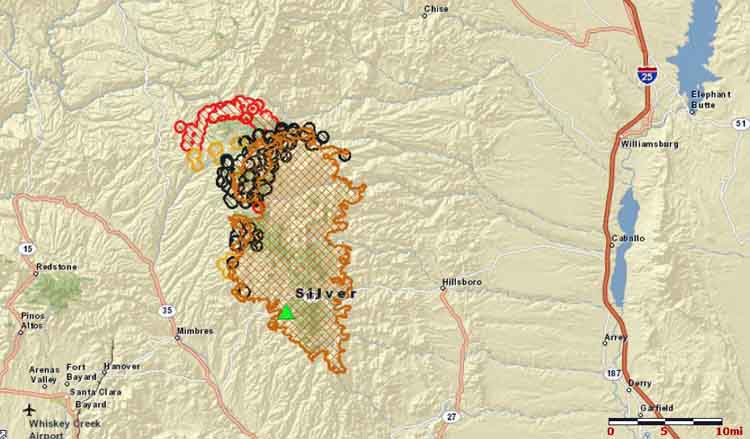
Map of the Silver Fire at 3:18 a.m. MDT, June 29, 2013. The red areas were the most recently burned. (click to enlarge)

The heat signatures captured by a satellite at 3:18 Saturday morning, shown in the map above, indicate that the Silver Fire spread several miles to the northwest over the last 24 hours.

Below is an update on the fire from the Incident Management Team, late Friday night:

Silver Fire June 28th PM Update- The Silver Fire continues to burn toward Reeds Peak to the NW and North. The South and East flanks of the fire are out and cold. The containment is 35%. The extreme weather has passed but the potential still exists for extreme fire behavior. The weather forecast calls for 20% chance of Thunderstorms with potential for dry lightning and a slight chance for wetting rain. Structure protection continues in the Cooney area.

****

(Originally published at 1:30 p.m. MDT, June 28, 2013)

Siliver Fire 6 am June 28, 2013 NWS photo by Tom Bird
Caption by the National Weather Service: “Words are hard to come by to express the nearly unbelievable nature of this photo. This shows a fully developed column off the Silver fire…BEFORE sunrise. The fire NEVER laid down last night. Intense and extreme fire behavior continued through the night. The Incident Commander asked the 100+ crew supervisors, with a couple thousand combined years of firefighting experience, how many of them had seen this before in their career. Only a handful had. This fire is exhibiting fire behavior that has never been seen in this part of the country.”   (click to enlarge)

The Silver Fire in southwest New Mexico exhibited EXTREME fire behavior late Thursday into early Friday morning. Pushed by a strong east wind it spread in a direction that was contrary to its usual movement and blackened about 10,000 more acres, bringing the total to 101,311. The Incident Commander is calling it 20 percent contained. While heavy smoke socked in the Mimbres Valley, the majority of fire growth occurred on the northwestern side of the fire. The east side near Winston did not have much activity Thursday and Thursday night.

The weather Friday will be slightly less dry, but conditions remain extreme. An upper ridge weather system will move in today, slowly moving smoke away, and allowing clouds to form. There is an opportunity for dry lightning this weekend, and a slight potential for precipitation on Monday.

Map of Silver Fire
Map of Silver Fire at 2:40 a.m. MDT, June 28, 2013, showing heat detected by a satellite. The red areas were the most recently burned. (click to enlarge)

And at 8:57 a.m. Friday, the National Weather Service out of El Paso sent this tweet:


Silver Fire
Silver Fire as seen June 17 from Incident Command Post
wrapping cabin on Silver Fire
Lolo Engine 416 beginning the process of wrapping a cabin on the Silver Fire to protect it from radiated heat and embers from the fire, undated InciWeb photo