Air tankers were used on Schroeder Fire the day after it started west of Rapid City

Two were flown in from New Mexico and Minnesota

Schroeder Fire helicopter
One of the South Dakota National Guard HH-60M Blackhawk helicopters working the Schroeder Fire at Rapid City, March 29, 2021. Photo via Pennington Co Sheriff.

This article was first published at FireAviation.com

4:44 p.m. MDT, March 30, 2021

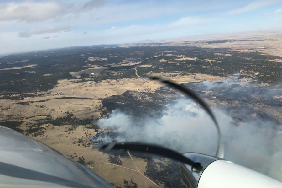
On Tuesday, the day after the 1,900-acre Schroder Fire broke out just west of Rapid City, South Dakota, two large air tankers were relocated to the tanker base at the airport.

Air Tanker 167 at Medford Oregon
File photo of Air Tanker 167, an RJ85, at Medford Oregon September 9, 2019. Photo by Tim Crippin.

Tanker 105, an MD-87, flew  in from New Mexico, and Tanker 167, an RJ85 arrived from Minnesota.

Each of the tankers had made at least two drops on the fire as of mid-afternoon Tuesday.

Bighorn Fire Tanker 105 Tanker 10 BAe-146
File photo of Tanker 105 (foreground), an MD-87 operated by Erickson Aero Tanker (N295EA), and Tanker 10, a BAe-146 (N472NA) operated by Neptune Aviation, working the Bighorm Fire near Tucson, June, 2020. Ned Harris photo.

Other aircraft working the fire today include a fixed wing aerial supervision module, two National Guard Helicopters, and a PC12 intelligence gathering aircraft owned and operated by the state of Colorado.

Fire officials said Tuesday afternoon there were no additional closures or evacuations, and residents along Cavern Road could return to their homes. Since Highway 44 is still closed from Rapid City, the local residents will need to access the area from Johnson Siding.

With some active fire still in the area, there is an expectation that the current road and neighborhood closures will continue through Tuesday night.

There has been no update on the size of the fire since it was mapped at 1,900 acres Monday evening.

The number of destroyed homes remains at one, and that resident on Blue Sky Road has been notified. At least two outbuildings have burned, as well as a deck on a residence.

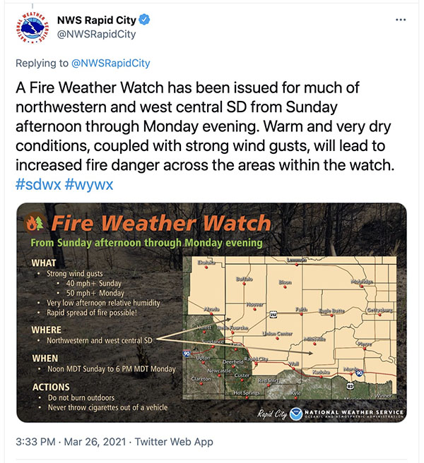
The elevated fire danger and the passage of the cold front with 50 mph+ winds which caused the fire to spread very rapidly was predicted two days before the fire started on Monday.

Weather forecast two days before the Schroeder Fire

The wind was too strong for any aircraft to be used safely or effectively Monday, so if the aircraft had been proactively prepositioned on Sunday they probably would have been grounded on Monday when the fire was reported that morning. One person we talked to on Tuesday who was not authorized to speak for the firefighting agencies about the air tankers said, “Yesterday the winds were too high. No one wanted to come to South Dakota.” However there was a report that a National Guard Blackhawk based in Rapid City made some marginally effective drops late in the day on Monday after the wind speeds decreased.

If you are a weather geek, you will be fascinated by the data captured as the cold front moved into the Schroeder Fire area on Monday, March 29. The fire was reported at 9:22 a.m. MDT Monday.

Schroeder Fire aircraft
Schroeder Fire as seen from an air attack or lead plane aircraft, March 29, 2021. @PennCoFire photo. The distortion of the propellers is caused by the rolling shutter that is used in most cell phones.
Schroeder Fire, March 29, 2021
Schroeder Fire as seen from Rapid City, March 29, 2021. @PennCoFire photo

Fires in the Black Hills prompt evacuations

Near Rapid City, Mount Rushmore, and Keystone

Updated at 12:25 a.m. MDT March 30, 2021

In a late night update fire officials said one home and two outbuildings are confirmed to have been destroyed by the Schroeder Fire west of Rapid City, SD.

Firefighters are working during the night in the Cleghorn Canyon, Nameless Cave, and Blessed Sacrament Church areas where they are patrolling and securing structures, in addition to the rest of the fire perimeter.


Updated at 9:22 p.m. MDT March 29, 2021

Map of Schroeder Fire
Map of Schroeder Fire, from a mapping flight at 7:30 p.m. March 29, 2020. Map provided by Schroeder Fire Information.

The Schroeder Fire just west of Rapid City, South Dakota was mapped at 1,905 acres at about 7:30 p.m. MDT March 29.

Fire officials said the blaze was reported Monday at 9:22 a.m. in the Schroeder Road subdivision, skipped across the canyon into the Westberry Trials subdivision and the footprint of the Westberry Trails Fire of 1988 .

A cold front with very strong winds came through around noon and pushed the fire south into the neighborhoods of Cleghorn Canyon, Nameless Cave, and Pinedale Heights.

Incident Commander Rob Powell said Monday afternoon that he was optimistic that they can keep the Schroeder Fire from crossing Highway 44.

A map showing evacuation areas is available at the Pennington County website.

The fire is human-caused and still under investigation, but that simply means it was not caused by lightning. Firefighters will staff the fire overnight. Suppression of the fire is a state responsibility, rather than federal.

“We are at record-dry conditions along with high winds playing a major factor in this fight,” said Jay Esperance, Division Director for South Dakota Wildland Fire.

Helicopters and a fixed wing air tanker have been ordered and will be used as needed when weather conditions allow. They can’t be used safely or effectively during strong winds, but a National Guard helicopter was used Monday afternoon after the wind speeds decreased. The Rapid City Air Tanker Base has been activated.


Originally published at 7:25 p.m. MDT March 29, 2021.

Map showing wildfires in the Black Hills
Map showing wildfires in the Black Hills, data from 2:36 p.m. MDT March 29, 2021.

At least three wildfires broke out Monday in the Black Hills of South Dakota. (see the map above)

The largest is the Schroeder Fire just west of Rapid City. Heat detected by a satellite at 2:36 p.m. MDT on Monday showed it to be at least 1,000 acres and primarily between Highway 44 and South Canyon Road. Evacuations are in effect. Officials said between 400 and 500 homes have been evacuated in Rapid City and one home and two outbuildings have been destroyed. A map showing evacuation areas is available at the Pennington County website. Suppression of the fire is a state responsibility, rather than federal.

Schroeder Fire map
Schroeder Fire map, data from 2:36 p.m. MDT March 29, 2021

At 2:36 p.m. Monday, another fire, the 244 Fire, was less than a mile northeast of Mount Rushmore National Memorial and about a mile southwest of Keystone. It has burned 75 to 100 acres and the Memorial is closed. Suppression of the fire is a federal responsibility, rather than state.

A third blaze, the 15-acre Keystone Fire, is about 1.5 miles south of Keystone. It is being suppressed by the state.

Highway 244 is closed at the west boundary of the Memorial, and the Highway 16A entrance is closed at the Keystone and Iron Mountain Boundary.

The fires were driven by low humidity and very strong winds out of the west at 18 to 35 mph. Gusts above 50 mph were recorded at the weather station at Mount Rushmore.

We will update this article as more information becomes available.

Fire in the Black Hills, March 29, 2021
A firefighter conducts a burnout on the 244 Fire near Mount Rushmore in the Black Hills, March 29, 2021. Photo courtesy of Great Plains fire information.
Fire in the Black Hills, March 29, 2021
The 244 Fire in the Black Hills near Mount Rushmore, March 29, 2021. Photo courtesy of Great Plains fire information.

Park Service denies request for July 4 fireworks at Mount Rushmore

“Potential risks to the park itself and to the health and safety of employees and visitors associated with the fireworks demonstration continue to be a concern and are still being evaluated as a result of the 2020 event,” said the National Park Service.

Mount Rushmore
The sculpture at Mount Rushmore is at the icon in this satellite photo.

The National Park Service has denied a request from the State of South Dakota to hold a July 4 fireworks display at Mount Rushmore this year.

Last year under pressure from South Dakota Governor Kristi Noem and former President Trump, fireworks were shot from the heads of the four presidents on the sculpture for the first time since 2009. In the interim they had been banned for having started 27 fires, left carcinogens in the water, and the trash dropped by the exploding shells onto the Monument and the forest can never be completely picked up. Fireworks were exploded over the sculpture and the Ponderosa pine forest 11 times between 1998 and 2009.

NPS Regional Director Herbert Frost wrote in a letter to the head of the state’s tourism department, first reported by The Hill Friday, that the NPS is “unable to grant a request to have fireworks at the Memorial.”

“Potential risks to the park itself and to the health and safety of employees and visitors associated with the fireworks demonstration continue to be a concern and are still being evaluated as a result of the 2020 event,” Frost wrote. “In addition, the park’s many tribal partners expressly oppose fireworks at the Memorial.”

“These factors, compiled with the COVID-19 pandemic, do not allow a safe and responsible fireworks display to be held at this site,” he added.

Frost noted that although progress is being made in fighting the pandemic, the situation is still “dynamic” and said it is “only prudent to make plans based on the best available science and public health guidance available today.”

In a joint statement, three members of Congress, Representative Dusty Johnson, Senator John Thune, and Senator Mike Rounds said,

Let’s be clear, this decision is political, not evidence-based. President Biden just said himself that Americans can safely gather by July 4 – what’s changed in a day? Last year millions watched the celebration in awe, and it’s a shame the administration is denying Americans that opportunity this year.

On March 11 in his address to the nation President Biden said,

Because here’s the point, if we do all this, if we do our part, if we do this together, by July the 4th, there’s a good chance you, your families and friends will be able to get together in your backyard or your neighborhood and have a cookout and a barbecue and celebrate Independence Day. That doesn’t mean large events with lots of people together, but it does mean small groups will be able to get together.

According to Johns Hopkins University, of all the U.S. states, as of March 14, 2021 South Dakota has the third-highest number of positive COVID-19 cases per capita, and the sixth-lowest rate of testing per capita. The state has never implemented a mask mandate.

From Forbes, March 13, 2021:

Four days before the fireworks celebration in 2020, a local wildfire update reported that multiple fires had affected nearly 16,000 acres in the Black Hills, near Mount Rushmore. But wildfire experts’ objections to the 2020 celebration went unheeded.

“Burning debris, the burning embers and unexploded shells fall into a ponderosa pine forest and ponderosa pine is extremely flammable,” Bill Gabbert, former fire management officer for Mount Rushmore, told the Argus Leader last year. “Shooting fireworks over a ponderosa pine forest, or any flammable vegetation, is ill advised and should not be done. Period.”

In a break from what had been the standard practice for decades, when the Mine Draw Fire broke out six miles from Mount Rushmore just days before the fireworks were exploded in 2020, Governor Kristi Noem’s office took control of all official information about the fire, shutting down the fire professionals who had always provided information to the public and the media as part of their regular jobs.

Mine Draw Fire
Mine Draw Fire, June 24, 2020. Photo by Custer State Park.

Agate Bed Fire burns 2,000+ acres in Western South Dakota

The blaze was driven by winds gusting above 30 mph

Firefighter attacks the Agate Bed Fire
Firefighter attacks the Agate Bed Fire March 6, 2021 near Fairburn, South Dakota. Fairburn VFD photo.

Firefighters from multiple counties stopped a fire east of the Black Hills in South Dakota Saturday after it had burned 2,000 to 3,000 acres during Red Flag Warning conditions.

The fire was approximately 9 miles east of Fairburn on the Buffalo Gap National Grassland.

“The majority of fire was in a wilderness study area, which complicated suppression efforts,” said Jim Strain, Assistant Chief of the Fairburn Volunteer Fire Department.

Saturday afternoon the wind was blasting, with sustained speeds of 15 to 25 mph with gusts above 30 mph while the relative humidity was in the high teens and the temperature in the high 60s — difficult conditions for firefighters. After dark the wind slowed, 5 to 10 mph but with occasional gusts of 15 to 25 mph. Sunday afternoon it increased to 15 mph and 25 mph gusts, along with 27 percent relative humidity.

Map, Agate Bed Fire South Dakota
Map showing the location of the Agate Bed Fire March 6, 2021 approximately 9 miles east of Fairburn, South Dakota. The red dots represent heat detected by a satellite. Heat on about two-thirds of the fire, which was mostly grass, cooled before the satellite overflight and was not detected.

Black Hills National Forest conducts 380-acre prescribed fire

Red Flag Warning in effect for the area Saturday

Victoria Prescribed Fire, Black Hills National Forest
Victoria Prescribed Fire, Black Hills National Forest. USFS photo by Matt Daigle.

The Black Hills National Forest conducted a 380-acre prescribed fire Wednesday through Friday of this week approximately 5 miles southwest of Rapid City, SD.

Today, Saturday March 6, a Red Flag Warning is in effect for the area.

“Warm temperatures and dry fuels, combined with very low humidity and gusty south to southwest winds, will result in extreme fire danger across the area,” the National Weather Service said in an advisory Saturday.

The forecast for Saturday predicts 17 to 24 mph winds out of the southeast and a minimum relative humidity of 11 percent. The strong winds are expected to continue Saturday night shifting to come from the west and then the northwest, with the RH ranging from 24 to 48 percent.

Red Flag Warning Black Hills
Red Flag Warning Black Hills, March 6, 2021.

The photos below were posted by Great Plains Fire Information Friday March 5, 2021.

Victoria Prescribed Fire, Black Hills National Forest
Victoria Prescribed Fire, Black Hills National Forest. USFS photo.
Victoria Prescribed Fire, Black Hills National Forest
Victoria Prescribed Fire, Black Hills National Forest. USFS photo by Matt Daigle.

At least they’re paid in sunsets

Wildland firefighters

Burning piles sunset Black Hills National Forest
Burning piles at sunset on the Black Hills National Forest. Photo by Josh Hoffmann.

Federal employees who fight fires for a living are grossly underpaid. That fact may have led to the old saying that they are “paid in sunsets.” Wildland firefighters usually battle fires in very remote areas and have opportunities to see sunsets from a wide variety of vantage points that are rarely visited by humans. When they see the sunset, they may have dragged themselves out of a sleeping bag on the ground 14 hours earlier and are dog-tired, dirty, sweaty, thirsty, and *hangry. But if the clouds, smoke, landscape, and sun all cooperate at the right time, they may take a minute to drink some of the last (warm) water they still have while enjoying and saving a mental snapshot of a red sunset enhanced by smoke. And then someone yells “Bump Up,” and they grab their tool again — with that image lingering in their mind. Tomorrow’s shift will be better.

Snow this time of the year can create excellent opportunities for land managers to burn debris piles left over from fuel reduction, thinning, or timber harvesting operations. The snow reduces the chances of the fire creeping out into dry vegetation, and when backs are turned igniting a wildfire.

Like many other parks and forests, the Black Hills National Forest in South Dakota and Wyoming has been burning piles in recent days. In their case, near Sheridan Lake, Deadwood South Dakota, and 10 miles south-southeast of Sundance, Wyoming.

Let’s be careful out there.


*Hangry: bad-tempered or irritable as a result of hunger.