WhoopUp fire map, noon July 19, 2011

UPDATE at 9:30 p.m. MT, July 19, 2011:

Below is an updated map of the WhoopUp fire, showing heat detected by satellites at 2:19 p.m. MT July 19, 2011. The red areas depict active burning, while the black indicates heat detected within the last 24 hours. The fire appears to be well established across the state line in South Dakota.
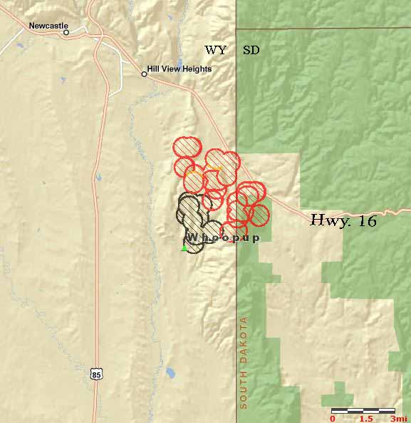
Whoopup fire map 1419, July 19, 2011
Whoopup fire map, 2:19 p.m. MT, July 19, 2011. MODIS/Bill Gabbert

The fire was mapped today at 5,544 acres, and is listed at 10% containment. On Wednesday the passage of a cold front will affect the fire, with strong northwest winds at 10 to 22 mph, with gusts up to 32. The wind, which will be more northerly in the late afternoon, could push the fire toward the southeast or south. The temperature will be much more moderate — instead of 100 degrees it will max out at 83 and the minimum relative humidity will be 31%.

“Gilbert”, one the commentors on our first article about this fire, said the firefighter that was injured when he fell, broke his pelvis:

The guy that fell is a member of the Newcastle vol fire dept as am I. He fell off a type 4 [engine] the first morning of the fire and broke his pelvis. He is home now but sore. Happened about 0800 the morning the fire started.

We asked a fire information officer about this accident today, and were told the only thing they knew was that a firefighter was injured when he or she fell. We hope the gentleman has a speedy recovery .

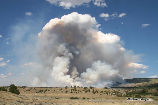
Here is a photo of the smoke from the WhoopUp fire, taken from Wind Cave National Park Tuesday evening, 31 miles southeast of the fire.

Whoopup fire from WICA
WhoopUp fire smoke, as seen from Wind Cave National Park at 6:42 p.m. MT, July 19, 2011. Photo: Bill Gabbert

We asked a fire information officer about the correct spelling of “Whoopup” and were told that it is one word, unlike what you may see elsewhere, and the “u” is supposed to be capitalized. So we will make an effort to remember: “WhoopUp”. In case you are wondering, the name comes from WhoopUp Creek, near the fire’s point of origin.

=================================

The map below shows heat on the WhoopUp fire near Newcastle, WY detected by a satellite at approximately noon MT, July 19, 2011. The red areas depict active burning, while the black indicates heat detected within the last 24 hours. The gap between the black and red does not mean there was no fire there, just that the satellite did not detect much heat in those locations when it passed overhead, perhaps due to light fuels (vegetation) that ignited and then burned out quickly.

The fire appears to have crossed the state line, moving from Wyoming into South Dakota.
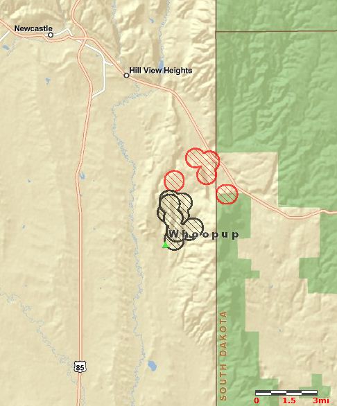
Whoopup fire map 1200, July 19, 2011
WhoopUp fire map, 1200 MT, July 19, 2011. MODIS

The map below shows the relationship of the WhoopUp fire to previous fires in the same area, in 2002 and 2003.
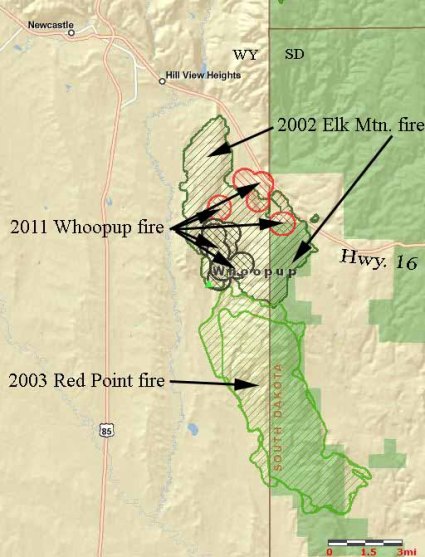
Whoopup fire-historical fires
WhoopUp fire and historical fires. MODIS and Bill Gabbert

Frank Carroll, Information Officer for the fire (normally with the Black Hills National Forest), told us at 2:45 p.m. on Tuesday that the latest acreage figure they have for the fire is 4,335 acres, but said it is not very current and the fire is significantly larger.

There has been a great deal of lightning in the Newcastle, WY and Custer, SD area over the last 48 hours, resulting in numerous fire starts. At least two of them are unstaffed. Firefighters “are pouring in” to the Newcastle area, Mr. Carroll said.

There were three injuries to firefighters — two were heat related due to the 100-degree temperatures, and the third was the result of a fall.

Joe Lowe’s Type 2 Incident Management Team, Rocky Mountain Area Team C, will assume command of the fire at 6:00 p.m. on Tuesday. Their last assignment, in June, was working on flooding in eastern South Dakota.

We have photos of the fire, HERE, HERE, and HERE.


Help us out by telling Google you like this article by clicking the Google +1 button below. Thanks!

Lead plane on the Whoopup fire

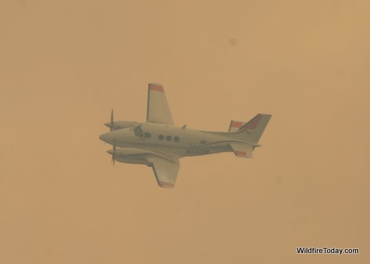
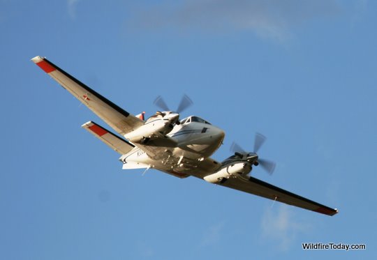
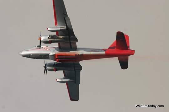
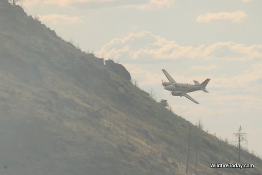
A lead plane is a small, twin-engine fixed wing aircraft the assists and directs the much larger air tankers that drop retardant on wildfires. They have a one-person crew, the pilot, who is very experienced in flying over fires in mountainous terrain with turbulent wind conditions. Their purpose is to determine a safe and effective flight path for the air tankers and to identify the exact location for the retardant drops. They will often make several passes over the target, sometimes from different directions, before they settle on the best approach for the much larger air tankers.

Lead plane, Whoopup fire
Lead plane, Whoopup fire. Photo: Bill Gabbert

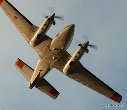
These photos are of the lead plane working in Ferguson Canyon on the Whoopup fire southeast of Newcastle, Wyoming, on June 18, 2011. This aircraft is a Beechcraft King Air 90 twin-turboprop that was dispatched out of Albuquerque Silver City, NM at 11:40 a.m. and spent the afternoon working with air tankers 45 and 07. All three aircraft were refueling and reloading retardant at the tanker base at Rapid City Regional Airport. Some lead planes have the capability of producing a puff of smoke to mark drop locations, but I didn’t see this lead plane doing that.

Lead plane, Whoopup fire
Lead plane, Whoopup fire. Photo: Bill Gabbert
Lead plane, Whoopup fire
Lead plane, Whoopup fire. Photo: Bill Gabbert

One interesting fact about lead planes is that some of their radio antennas are installed on the bottom of the aircraft, rather than the top. This makes it easier to communicate with firefighters below them on the ground. This King Air has at least three on the bottom — two on the wings and one or more on the fuselage.

Lead plane, Whoopup fire
Lead plane, Whoopup fire. Photo: Bill Gabbert


======================

Update 7-26-2011: we put together a slide show of more photos.


Help us out by telling Google you like this article by clicking the Google +1 button below. Thanks!

More photos of the Whoopup fire

Here are a few more photos of the Whoopup fire southeast of Newcastle, Wyoming, taken Monday, between 1:15 p.m. and 7:45 p.m.

Whoopup fire, structure protection
Group Supervisor for Structure Protection, Tim Daley (without a cap), lines out engine crews that just arrived from Sundance, WY and Hill City, SD. They were assigned to protect structures near Ferguson Canyon.
Whoopup fire
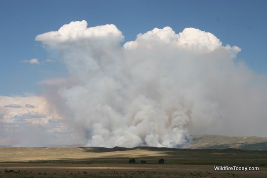
Convection over the Whoopup fire causes condensation at the top of the smoke column, creating two "ice caps" at 3:17 p.m., July 18, 2011. Photo: Bill Gabbert
Whoopup fire
The southwest side of the Whoopup fire at 3:33 p.m., July 18, 2011. Photo: Bill Gabbert
Whoopup fire
The west side of the Whoopup fire, at 4:32 p.m. July 18, 2011. Photo: Bill Gabbert
Whoopup fire, structure protection
An engine stands ready to protect a home on the north side of Ferguson Canyon on the Whoopup fire, 6:00 p.m, July 18, 2011. Photo: Bill Gabbert


======================

Update 7-26-2011: we put together a slide show of more photos.


Help us out by telling Google you like this article by clicking the Google +1 button below. Thanks!
Whoopup fire near Newcastle WY

UPDATE at 12:30 a.m. July 19, 2011:

WildCAD reports that the Whoopup fire southeast of Newcastle, Wyoming has burned 2,500 acres.

=======================================

Tanker 07, Whoopup fire
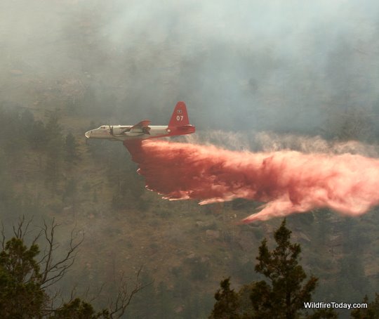
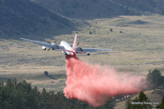
Tanker 07 dropping in Ferguson Canyon on the Whoopup fire at 6:23 p.m., July 18, 2011. Photo: Bill Gabbert

I had the opportunity to take some photos at the Whoopup fire that started Monday morning southeast of Newcastle, Wyoming near the South Dakota/Wyoming state line. At about 4 p.m. the fire had burned an estimated 1,000 acres, according to firefighters at the scene. WildCAD shows that it was reported at 1:45 a.m. on Monday, July 18. I have not heard what the cause was, but another fire a few miles farther east was started by lightning.

The photo above shows air tanker 07, a P2V, making a drop to protect some structures in Ferguson Canyon. The lead plane kept making low passes from every direction, trying to figure out a way to get in there (and out of there) amid the smoke. Finally two air tankers showed up, 07 and 45, and following the lead plane one at a time, made it look easy.

Whoopup Fire
South end of the Whoopup fire, 4:12 p.m., July 18, 2011. Photo: Bill Gabbert

In cooperation with the fire managers, deputies from the Weston County Sheriffs office evacuated approximately 14 homes in Ferguson Canyon. When I left the area at 7:30 p.m. the fire had spotted into and across the canyon and was burning along the road at the east end of the canyon. The fire also threatened the fire lookout tower on Elk Mountain, causing the Forest Service employee there to evacuate to the USFS office in Newcastle.

Whoopup fire
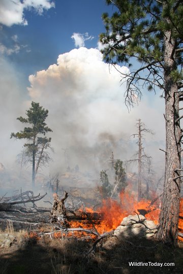
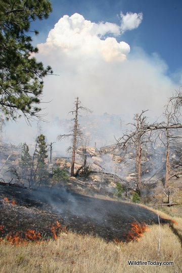
The southwest side of the Whoopup fire, July 18, 2011. The area is littered with standing dead snags and fallen trees left over from the last fire in the area. Photo: Bill Gabbert
Whoopup fire
Tanker 45 dropping at the mouth of Ferguson Canyon on the Whoopup fire, 6:16 p.m., July 18, 2011. Photo: Bill Gabbert

The fire name comes from a nearby creek, Whoopup Creek, which is near the first report of the fire.

The main factors driving the fire are standing snags and fallen trees left over from a previous fire in the area, grass and herbaceous vegetation in the old burn scar, and the temperature on Monday which reached 100 degrees according to the trusty thermometer in my truck. The wind was moderate on Monday afternoon, estimated at 4-6 mph with occasional stronger gusts, mostly out of the southwest. The RAWS weather station in Red Canyon 24 miles southeast of the fire recorded a high temperature of 101 degrees at 5:00 p.m. on Monday and winds at 3-8 with gusts in the low teens. The low relative humidity was 24% — not extreme weather at all, except for the temperature.

The weather forecast for Tuesday afternoon in the area of the fire will be about the same as Monday, with a high temperature of 97, relative humidity of 24%, and winds at 5-7 out of the southwest, west, and northwest.

Whoopup fire
Tanker 45 just after a drop in Ferguson Canyon on the Whoopup fire at 7:14 p.m., July 18, 2011. The doors on the tanks are still open. Photo: Bill Gabbert

Below is a map showing the approximate location of the Whoopup fire.
Continue reading “Whoopup fire near Newcastle WY”

Dinosaurs threatened by wildfire — again

When I saw the “Dinosaurs survive wildfire” headline today in the Rapid City Journal, at first I thought it was referring to the article pointed out yesterday by @Rachel_Rocket that appeared in my Twitter feed. Rachel’s tweet linked to a recent study in Australia which concluded that bushfires appeared in that country 50 million years earlier than previously thought and may be associated with the demise of the dinosaurs.

Dinosaur Hill fire
Photo by Kristina Barker/Rapid City Journal

But it turned out that the Rapid City Journal was more interested in a wildfire that threatened some dinosaurs YESTERDAY. This time it was life-sized replicas of them in Dinosaur Park. Pushed by 12 mph winds with gusts up to 31, the fire burned three to five acres before being controlled by firefighters from the Rapid City Fire Department and other agencies. This may be one of the rare examples of it being reported that FIREFIGHTERS SAVED THE DINOSAURS.

The Rapid City Journal has more info and photos HERE, and an interesting video showing firefighters in action HERE.

Australia’s Black Saturday fires: before and after photos

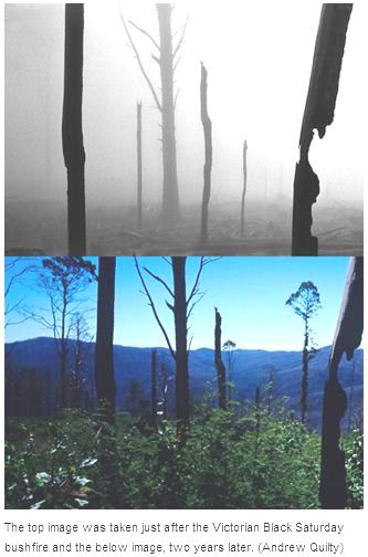
Black Saturday bushfires photosI like to look at before and after pictures. One of the best examples is the book of photographs that compare the photos taken on General George Custer’s 1874 expedition through the Black Hills of South Dakota, with photos taken by Ernest Grafe and Paul Horsted and published in the book Exploring With Custer: The 1874 Black Hills Expedition in 2003. The differences in vegetation help to explain why we now have larger fires that are more difficult to control.

Andrew Quilty, a photographer on the other side of the world, has done something similar, but instead of waiting 129 years for the after pictures, he took photos immediately after the February, 2009 Black Saturday fires in Australia, and then again two years later. One is on the left, and others are HERE.

Thanks Dick