Thomas Fire spreads into Santa Barbara County

New mandatory evacuation orders issued. New estimates show approximately 230,000 acres have burned.

Above: The Thomas Fire as seen from Sisar Peak east of Ojai at 9:07 a.m. PST December 10, 2017.

(UPDATED at 9:58 p.m. PST December 10, 2017)

The Thomas Fire has spread well into Santa Barbara County, and Sunday afternoon was on the slopes north of Carpinteria, California. The strong northeast Santa Ana wind slowed, as has the fire growth, but the vegetation is so dry that a moderate wind can still keep it moving at a persistent pace

(All articles on Wildfire Today about the Thomas Fire are tagged “Thomas Fire”.)

Sunday evening the U.S. Forest Service reported the fire has burned 230,000 acres. If this is accurate it puts it at number 5, near the top of the list of the largest fires in the recorded history of California.

top 20 largest fires in California

The forecast calls for wind on the slopes above Carpinteria Sunday night to be from the northeast at 10 mph, variable directions on Monday, and then Monday night to again be from the northeast but stronger, 15 mph with gusts to 23. The relative humidity will remain in the teens night and day through Tuesday. This could lead to active fire behavior throughout that period.

Using heat sensor data from a satellite, we mapped the additional acres that burned on the west side of the fire Saturday night and early Sunday morning. It is shown in blue on the map below, and this freshly burned area covers about 40,000 acres. The data is not verified, since at times the heat sensor was overwhelmed by hot particulate matter in the smoke plume outside the actual fire perimeter, so this may change after more accurate information is available from an overnight fixed wing aircraft mapping flight.
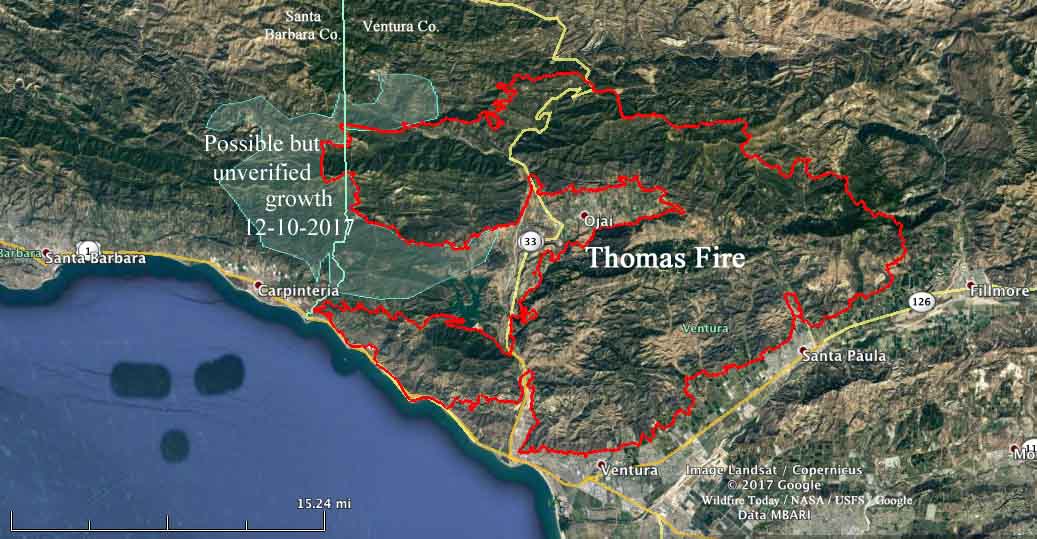
map Thomas fire Carpinteria california
Draft map showing an approximation of the additional acres (in blue) that burned in the Thomas Fire Saturday night and Sunday morning. This is preliminary and subject to change. Click to enlarge.

****

(UPDATED at 4:55 p.m. PST December 12, 2017)

At a town hall meeting about the Thomas Fire at San Marcos High School today, officials provided updated information.

The fire made a major run during much of the day on Sunday, adding an estimated 50,000 acres which could bring the total size up to around 225,000 acres by the end of the day. This would make it the 5th largest in recorded history of the state. These numbers are subject to verification by aerial mapping scheduled for Sunday night.

Town Hall meeting Thomas Fire
Town Hall meeting about Thomas Fire, 4 p.m. December 12.

An additional 100 fire engines were ordered for the Santa Barbara area.

The live broadcast was hosted by VCFD_PIO on Periscope.

By the numbers:

Structures Threatened: 15,000
Structures Destroyed: 754
Structures Damaged: 162
Engines: 611
Water Tenders: 31
Helicopters: 30
Hand Crews: 55
Dozers: 51
Total Personnel: 4435

****

(Updated at 9:51 a.m. PST December 10, 2017)

New evacuation orders have been issued for areas in Santa Barbara County as the Thomas Fire aggressively spreads further west. Saturday afternoon it moved into the county north of Carpinteria putting up massive convection columns of smoke Saturday night and Sunday morning as strong winds and very low humidity persisted throughout the night.

The fire continues to burn actively to the north, east, and west threatening structures in parts of the cities of Ventura, Ojai, Casitas Springs, Santa Paula, Carpinteria, Fillmore and the unincorporated areas of Ventura County and Matilija Canyon. It is expected to spread towards Sespe Wilderness and the Sespe Condor Sanctuary.

CAL FIRE reported Sunday morning that the Thomas Fire has burned 173,000 acres and destroyed 537 structures, damaging 118 others.
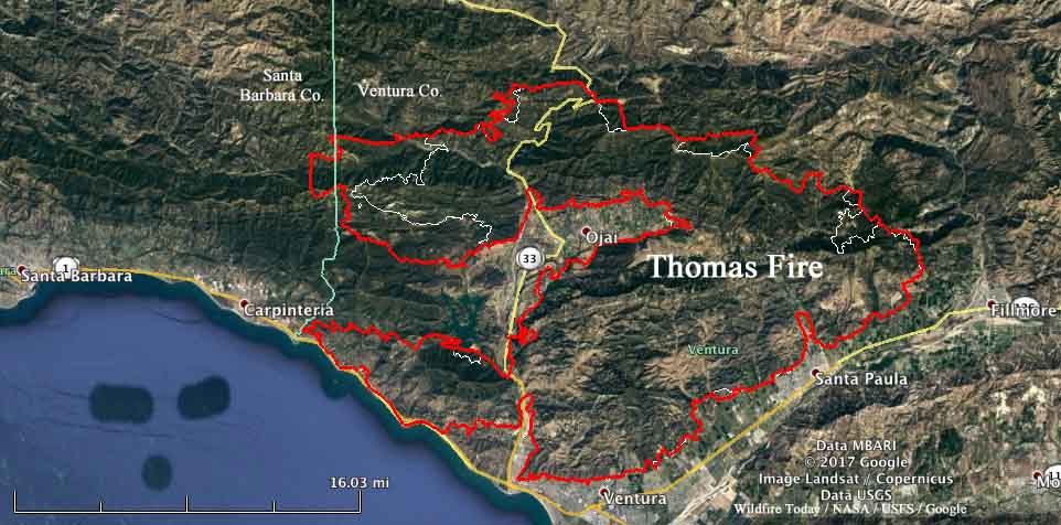
thomas fire map december 10 2017
Map of the Thomas Fire. The red line was the perimeter at 9:30 p.m. PST December 9, 2017. The white line was the perimeter 24 hours before.

The latest information about evacuations is at the Santa Barbara County website, but generally, as of 7 a.m. Sunday, the new area is “north of Highway 192, E. Valley Road, east of Buena Vista Drive, to include the 900 block of Park Lane, is a mandatory evacuation zone. Everything south of Highway 192, E. Valley Road, east of San Ysidro, is under a voluntary warning order.” (map) An evacuation shelter has been established at the UCSB Recreational Center, 516 Ocean Road, Santa Barbara.

The weather continues to be a challenge for firefighters. The Sunday forecast call for a Red Flag Warning including winds northeast at 20 to 30 mph with gusts up to 45 mph. And on Monday, 15 to 20 mph with gusts to 35 mph.

Firefighters Thomas Fire
Firefighters on the Thomas Fire at 4 a.m. PST December 10, 2017. Photo by Santa Barbara County Fire Department.

Thomas Fire continues to march to the west

The fire has burned 155,000 acres near Ventura, Carpinteria, and Ojai in Southern California. Ventura County Fire Department reports 600 structures have been destroyed.

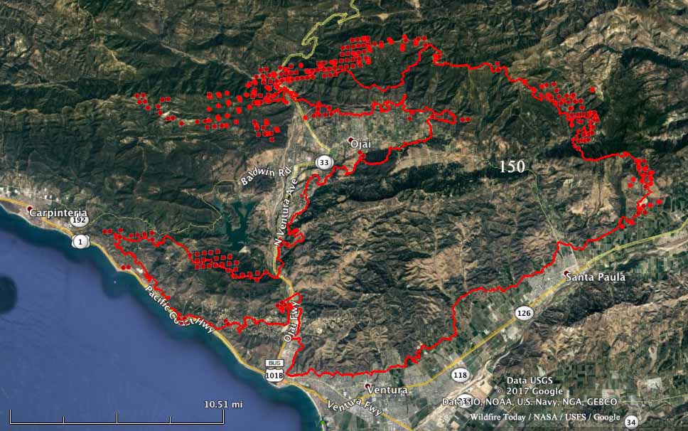
Above: The red line was the perimeter of the Thomas Fire at 9:30 p.m. PST December 8. The red dots represent heat detected by a satellite at 12:45 p.m. PST December 9, 2017.

(UPDATED at 6:52 p.m. PST December 9, 2017)

The 155,000-acre Thomas Fire has moved into Santa Barbara County near Divide Peak. Late Saturday afternoon the Incident Management Team reported that 460 structures have been destroyed in the city of Ventura and another 140 in the rest of Ventura County.

Most of the growth of the fire Friday night and Saturday morning was on the west side. The east side northwest of Fillmore was also active and air tankers and helicopters were used with good results there Saturday.

As the fire moves closer to Carpinteria 50 engines have been staged in the city and preparations are being made to protect structures and construct firelines. The fire is about 5 miles northeast of the intersection of Highways 1 and 150 on the east side of the city.

An unmanned aerial aircraft is being used to provide a live video feed to firefighters.

About 4,400 personnel are assigned to the fire and a large order for additional resources was placed today. The estimated costs to date are $25 million.

****

(UPDATED at 5:45 a.m. PST December 9, 2017)

The Incident Management Team reports that the Thomas Fire has destroyed 476 structures and burned 143,000 acres. Some mandatory evacuation orders have been lifted but many are still in place for some locations in the Ventura and Ojai areas.

On Friday the fire was very active across most of the north side, west of Lake Casitas, and northwest of Fillmore. It is expected to spread towards Santa Barbara County, Sespe Wilderness and the Sespe Condor Sanctuary.

Temporary residential access will be permitted on Saturday 12/9/17 and Sunday 12/10/17 during the hours of 9:00 am and 4:00 pm for residents who live in the areas affected by the Thomas Fire.  The access will be by escort only.  A check-in tent will be set up in the parking lot of Temple Beth Torah located at 7620 Foothill Road.  Residents must be able to show proof of residency (Driver’s License, Utility Bill, etc.) to be permitted to enter.  Entry will be limited to 2 persons per household.  Personal vehicles will not be allowed into the area.  Residents will be driven to their home and allowed a 15-minute period of time to get personal necessities (clothing, medication, etc.). For safety purposes, access will not be permitted to home sites which have been destroyed or sustained damage that poses a safety risk.

****

(UPDATED at 5:24 p.m. PST December 8, 2017)

The Ventura County Fire Department has revised the number structures destroyed in the Thomas Fire from 91 to 401.

Friday afternoon the fire was very active on the north side — north of Wheeler Springs, and on the east side northwest of Fillmore. It was fairly quiet around Ojai with the exception of a controlled burnout to help tie in some fireline south of the south end of Boardman Road.

(All articles on Wildfire Today about the Thomas Fire are tagged “Thomas Fire”.)

The 747 airtanker that dropped about 57,000 gallons of fire retardant on the Thomas Fire today is under contract to CAL FIRE.

****

(Originally published at 10:40 a.m. December 8, 2017)

The 132,000-acre Thomas Fire is far from being contained. Over the last two days it has been spreading to the west, almost enveloping the city of Ojai and growing closer to Carpinteria as it burns near the Pacific Ocean.

3-D wildfire ventura thomas fire ojai
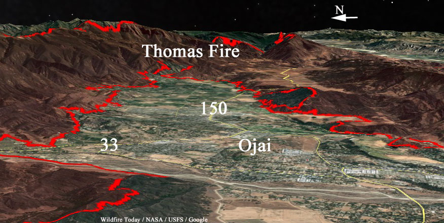
This 3-D view of the Thomas fire is looking east over Ojai, California. The (red) fire perimeter was valid at 11 p.m. PST December 7, 2017.

(All articles about the Thomas Fire on Wildfire Today are tagged “Thomas Fire”.)

These numbers will no doubt change in the next week or so, but officials report that 73 residential, 3 commercial and 15 outbuildings have been destroyed, mostly in the Ventura area.

This huge “megafire” is being fought with 471 engines, 28 hand crews, 12 helicopters, 26 dozers, and 7 water tenders, for a total of 2,509 personnel.

thomas fire wildfire map ojai ventura
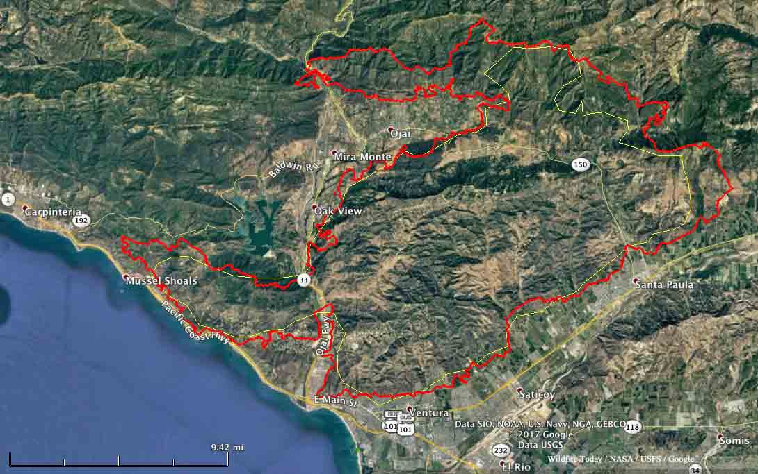
The red line on the map of the Thomas Fire was the perimeter at 11 p.m. PST December 7, 2017. The white line was the perimeter about 24 hours before. Click to enlarge.

Thomas Fire almost surrounds Ojai, California

Wednesday night the fire spread further up the coast toward Carpinteria

(UPDATED at 8:24 p.m. PST December 7, 2017)

The northeast and northwest sides of the Thomas Fire continued to be very active again on Thursday. Fire authorities said 427 structures in Ventura have been destroyed and at least 85 more were damaged. Approximately 12 were destroyed in unincorporated areas of Ventura County. Ojai is becoming even more boxed in by the fire, but so far that community and Carpinteria, where the blaze is knocking on the southern boundary of the city, have avoided any large losses in the fire.

(All articles about the Thomas Fire on Wildfire Today are tagged “Thomas Fire”.)

The additional area burned Thursday brings the total number of acres up to approximately 129,000 according to our estimates. At 6:30 p.m. CAL FIRE was calling it 115,000 acres.

Until the strong Santa Ana winds subside, there is not a lot that firefighters can do to stop major spread of the fire.

map thomas fire
The red line on the map of the Thomas Fire was the perimeter at 10 p.m. PST December 6, 2017. The red dots represent heat detected by a satellite in the 12-hour period ending at 8 p.m. PST December 7, 2017. Click to enlarge.

****

(UPDATED at 1:15 p.m. PST December 7, 2017 to include a better map below)

Strong winds Wednesday night from the east and northeast continued to push the Thomas Fire further to the west and north. It spread along the coast toward Carpinteria and as of 2 a.m. Thursday was about a mile south of Highway 150 where the road enters the city.

The fire also moved around Ojai on the north side, blazing a new path to the west two miles wide by eight miles long and crossing, again, Highway 33 northwest of the city. Ojai is now surrounded on three sides by the Thomas Fire.

Click on the map below to see a larger version.

map Thomas fire December 6 2017
The red line was the perimeter of the Thomas Fire at 10 p.m. PST December 6, 2017. The yellow line was the approximate perimeter at 1 a.m. PST December 5. Click to enlarge.

The Ventura County Fire Department is calling it 96,000 acres, but we think it was least 112,000 acres when the data for the map above was collected at 10 p.m. December 6. The unofficial threshold for a fire to obtain “megafire” status is 100,000 acres… so, it qualifies.

Wednesday night a weather station at Oxnard recorded east and northeast winds of 12 to 27 mph gusting up to 32 mph.

Evacuations have been ordered for areas near Carpinteria and Ojai.

red flag weather
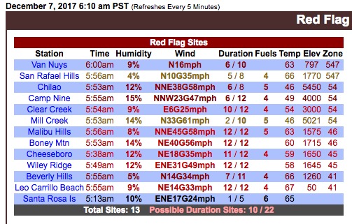
Weather stations in the Los Angeles area that meet the Red Flag Warning criteria at 6:10 a.m. PST December 7, 2017.

Articles on Wildfire Today about this fire are tagged Thomas Fire.

Thomas Fire burns to the ocean

The fire has burned at least 65,000 acres in Ventura County.

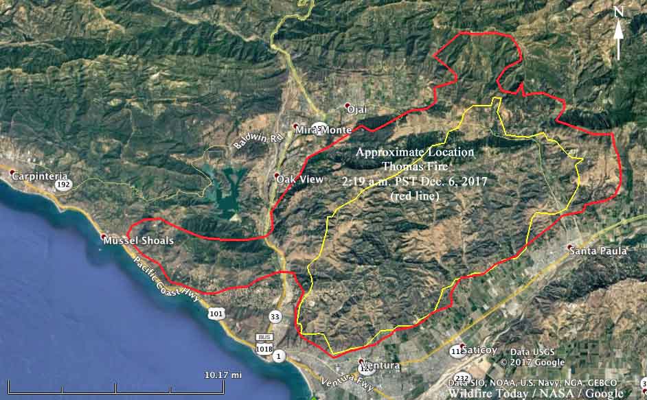
map Thomas Fire Ventura beach ocean 101
The red line on the map shows the approximate location of the Thomas Fire at 2:10 a.m. PST December 6, 2017. The yellow line was the approximate location 25 hours earlier. Unofficial map developed from satellite data. Click to enlarge.

(UPDATED at 10:20 p.m. PST December 6, 2017)

The Thomas Fire north of Ventura, California continued to grow on the northeast side, east of Ojai on Wednesday. The Ventura County Fire Department reported Wednesday evening that the fire has now burned 90,000 acres.

****

(Originally published at 6:36 p.m. PST December 6, 2017)

After burning into Ventura, California on Monday the Thomas Fire continued to grow, pushed by very strong Santa Ana Winds usually out of the northeast. On Tuesday the winds were not quite as strong but the problem for firefighters was the variable direction. Beginning at 11 a.m. winds out of the east and south spread the fire across Highway 33, the route from Ventura to Ojai, through oil fields and over a ridge until it reached and in some places crossed, Highway 101 northwest of Ventura where it reached the beach in some places. Helicopters dropped water on the fire overnight near Foothill Road and at Solimar Beach.

The Thomas Fire is now well north of Highway 150, east and northeast of the city of Ojai.

Firefighters have not had time to accurately tally how many structures have been destroyed — the latest estimate is 150 including the Vista Del Mar Hospital —  but the number may be significantly larger when the smoke clears.

On Tuesday fire officials reported the fire had burned 55,000 acres. Wednesday morning a spokesperson for the Ventura County Fire Department said it had increased to 65,000 acres.

Over 1,000 personnel are fighting the blaze. At least 27,000 residents were ordered to evacuate Tuesday, but that number grew when the fire crossed Highway 33 and threatened the coastal areas.

The wind has made it difficult to use firefighting aircraft, but the forecast for the mountains northeast of Ventura on Wednesday includes 10 to 14 mph northeast winds gusting at 16 to 21. This may make the use of the 30 air tankers that will be in California Wednesday, possible. The forecast also predicts 74 degrees and 9 percent relative humidity, which are weather conditions conducive to significant fire spread.

Three large SoCal wildfires in one photo

Creek Fire Rye Fire Thomas Fire
From near to far, Creek Fire, Rye Fire, and Thomas Fire.

The ABC7 helicopter crew was able to get all three large Southern California fires on one photo at 1:03 p.m. PST today. The nearest one is the 11,000-acre Creek Fire that has closed and crossed the 210 freeway near Sylmar. Next is the Rye Fire, which we have not yet written about. It has burned about 1,000 acres in Santa Clarita.

In the distance is the 45,000-acre Thomas Fire which has burned into Ventura.