Strong winds in South Dakota through Thursday

Weather forecast, Wind Cave NP October 16-18, 2012

Weather forecast, Wind Cave NP October 16-18, 2012

The weather forecast above is from the National Weather Service and is for Wind Cave National Park in southwest South Dakota. (Click on the image to see a larger version.)

Very strong winds and enhanced fire danger will prevail over South Dakota through Thursday. Thanks to a cold front moving through the area, sustained wind speeds in some area should be in the 20s, 30s, or 40s with gusts in some areas at 40 to 60 mph.

Below is an excerpt from a message distributed today by Darren R. Clabo, South Dakota State Fire Meteorologist.

=============================================================

A strong upper level trough will force a potent cold front to push across the state this evening. A few showers are possible along this frontal boundary and some of the weather models are even showing a wetting rain over western SD and the Black Hills.

Some lightning may accompany these showers so we’ll have to watch for any new ignitions.

Temperatures will quickly drop with this front but the real change will be seen in the winds: southwest winds will switch to the northwest and dramatically increase in speed. Gusts to 40 mph are possible overnight behind the front as it crosses the state.

Post-frontal conditions can then be expected tomorrow. Highs will only reach the mid to upper 50s across the prairies with mid 40s expected over the Black Hills. A very strong pressure gradient will persist throughout the day. This will allow the northwest winds to reach sustained speeds 35-45 mph with gusts exceeding 60 mph. A High Wind Watch is in place for this event. In addition, the post-frontal airmass will be quite dry and minimum RHs will range from 15% over southwestern SD to 25% over northeastern SD.

Critical fire conditions will ensue. Expect Extreme Fire Danger over all of the SD plains with Red Flag Warnings likely over East River. Explosive fire growth is possible any in the state tomorrow with the wind and exceptionally dry fuels. The strong northwest winds will continue throughout Wednesday night.

Thursday will not bring much relief as the northwest winds will like again be in the 30-40 mph range with gusts exceeding 50 mph. There may be some precipitation across northeast SD but the rest of the state will see dry conditions with enhanced fire danger once again. Highs will be in the 50s.

Red flag warnings, October 2, 2012

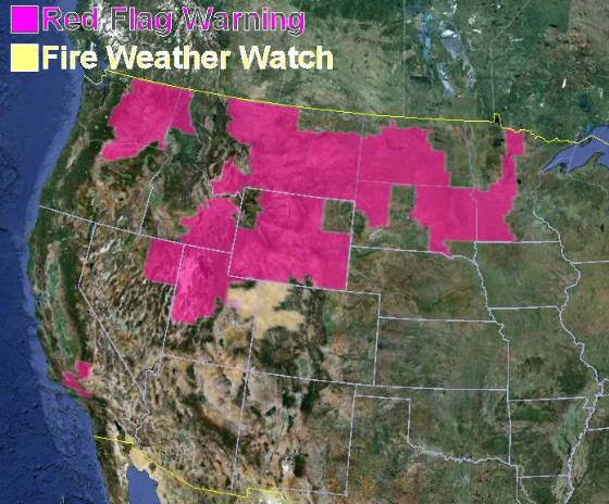
Wildfire Red Flag Warnings, October 2, 2012

Wildfire Red Flag Warnings, October 2, 2012

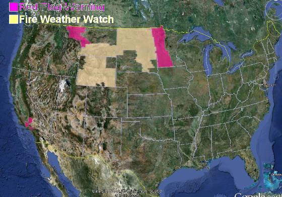
Quite a bit of the country is under a red flag warning today, including portions of California, Washington, Oregon, Idaho, Nevada, Utah, Montana, Wyoming, North Dakota, South Dakota, and Minnesota. Other than California, this may be one of the last red flag warnings for these states, as precipitation and cooler weather will be moving into some of these areas.

Wildfire potential and fire behavior advisories

Fuels and fire behavior advisories

Fuels and fire behavior advisories

Five geographic areas have released updated fuels and fire behavior advisories: Northwest, Northern Rockies, Rocky Mountain, Western Great Basin, and northern California.

Fuels and fire behavior advisories

Wildfire potential

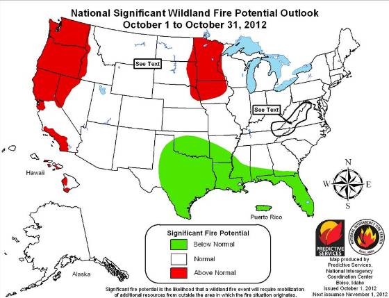
The Predictive Services section at the National Interagency Fire Center has issued their National Wildland Fire Potential Outlook for October, 2012 through January, 2013. If it is correct, Minnesota, the northwest, and portions of California and Iowa will be active in October. After that, it’s southern California.

Wildfire outlook, October, 2012

Wildfire outlook, November - January

Here is an excerpt from the NIFC report:

==============================================================

Significant Fire Potential

  • For October above normal significant fire potential is predicted across the northwestern quarter of the U.S. including portions of Washington, Oregon, Idaho and California. Above normal significant fire potential also exists across portions of the upper Midwest. The mountains and foothills of central and Southern California will also experience above normal significant fire potential. Portions of the Hawaiian Islands continue to see elevated significant fire potential as well.
  • The southeastern U.S. will continue to see periodic precipitation events and reduced significant fire potential.
  • The rest of the country will have normal significant fire potential.
  • As the fall leaf drop season develops the potential exists for a return to above normal significant fire potential across portions of the Appalachian Mountains.
  • Also during mid-October through early November Southern California will likely experience periodic off shore flow events leading to elevated significant fire potential.


Red flag warnings and record-breaking heat expected in California

Red Flag Warnings, October 1, 2012

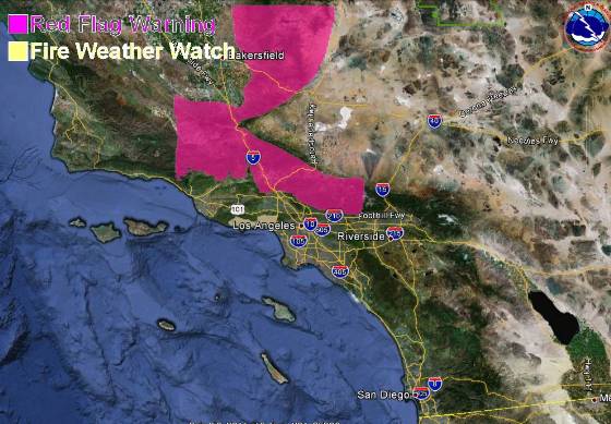
A weather forecast for record-breaking triple-digit heat and single digit humidities has brought out a red flag warning for some areas in southern California for Monday and Tuesday. The temperatures are expected to be about 20 degrees hotter than normal,  between 95 and 105 at the lower elevations in the mountains of Los Angeles and Ventura Counties on Monday, then a few degrees cooler on Tuesday. Downtown Los Angeles is expected to hit 100 degrees on Monday, with it reaching 105 degrees in Burbank and Pasadena.

Northeast winds at 10 to 20 mph with 30 mph gusts are expected on Monday, with Tuesday afternoon bringing 25 mph onshore winds.

Red Flag Warnings, October 1, 2012

The map below shows the area in southern California covered by the red flag warning, which is in effect from 6 a.m. Monday until 6 p.m. PDT Tuesday.

Red Flag Warning, Southern California, October 1, 2012

There is also a red flag warning for some areas in northwest Montana for gusty winds and low humidities from 11 a.m. through midnight MDT on Monday. The winds are expected to be southwest at 15 to 25 mph with gusts up to 50, with the humidities as low as 16 percent.

The passage of a cold front has resulted in a red flag warning for western Minnesota from 2 p.m. until 7 p.m. CDT on Monday. Winds should be northwest at 20 with gusts up to 30 mph along with humidities as low as 20 percent.

A fire weather watch is in effect for areas in Wyoming, Montana, North Dakota, and South Dakota.

Updated drought map

Drought Monitor Map, September 25, 2012

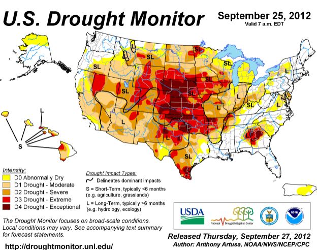
Drought Monitor Map, September 25, 2012An updated drought monitor map was released today, current as of September 25, 2012. It is similar to the map we posted on September 8, but has a few areas moving into the next higher level of dryness. As before, most of the United States is in some form of drought.

Dry lightning could bring more fires to the Northwest

Map showing smoke from wildfires

Originally published September 22, 2012, 8:47 a.m. PT

The dry lightning that is in the forecast for portions of Washington and Oregon could bring more fires to an area that already has its hands full dealing with dozens of blazes. On Friday the National Weather Service issued a Red Flag Warning for the lightning, but now the timing of the event has changed. That forecast predicted it would begin Friday night, but a revision now says isolated to scattered lightning will start Saturday night and continue through Sunday night.

The areas affected include the Cascade Mountains in central and north Oregon, the southern Washington Cascades, and the Columbia basin in Washington. If any rain occurs, it will be light and amounting to less than 1/10 inch. The thunderstorms will be high-based and could produce outflow winds of up to 45 mph.

We are not aware of a large amount of lightning that has occurred in this area yet this weekend, however as of 8:45 a.m. PT, there have been a couple of positive strikes detected very recently in north-central Oregon, which seems to be ahead of the NWS’s revised schedule.

We will update this article later on Saturday if we hear of any significant dry lightning occurring. I hope our loyal readers in Washington and Oregon will post comments about their observations as well.

The map below shows the Red Flag Warnings for Washington and Oregon and a Fire Weather Watch for western Utah.

Red Flag Warnings, September 22, 2012

The smoke map indicates that wildfire smoke created in Washington and Idaho is migrating across the southern tier of states.

Map showing smoke from wildfires
Map showing smoke from wildfires, 4:25 a.m. MT, September 22, 2012


Wildfire briefing, September 21, 2012

Idaho fires burn through uranium mine areas

As if firefighters and local residents didn’t have enough to worry about in Idaho, now we are hearing about wildfires that have burned through, or may burn through, areas with uranium mines. At least one of the mines is in the footprint of the Mustang Complex Fire. In case you have not received your copy of Uranium Market News, here is an excerpt from that publication:

Friday September 21, 2012, 1:55pm PDT

Reuters reported an Idaho wildfire has burned through three former mining sites with traces of radioactive uranium and thorium and is currently burning through a fourth site.

As quoted in the market news:

As a precaution, state environmental authorities planned to take air samples in North Fork, a small community in the fire zone north of Salmon, to assess any radioactive hazards posed by fire damage to the sites.

One area of concern is a defunct uranium mine and milling operation 5 miles west of North Fork, where the U.S. Environmental Protection Agency conducted a cleanup several years ago of polluted soil, hazardous wastes and piles of raw uranium and thorium ore.

The Missoulian has more information about the radioactive uranium and thorium issue.

The northwest to receive more dry lightning Friday night and Saturday

Dry lightning and thunderstorms with minimum rain are in the forecast for parts of Washington, Oregon, and Idaho, according to a fire weather forecast from the National Weather Service: (do you love their all-caps format as much as I do?)

HIGH PRESSURE WILL BEGIN TO WEAKEN AS A COMPACT LOW PRESSURE SYSTEM BARRELS INTO NORTHERN OREGON. ISOLATED TO SCATTERED DRY THUNDERSTORMS WILL BE POSSIBLE WITH THIS FEATURE EARLY SATURDAY MORNING THROUGH SUNDAY. GREATEST THREAT FOR SATURDAY MORNING AND SATURDAY AFTERNOON WILL BE ALONG THE CASCADE MOUNTAINS AND VALLEYS MAINLY SOUTH OF LAKE CHELAN. THE THREAT OF THUNDERSTORMS WILL SHIFT TO THE SOUTHEAST ACROSS SOUTHEAST WASHINGTON AND INTO THE CENTRAL IDAHO PANHANDLE SATURDAY NIGHT INTO SUNDAY. MOISTURE WILL BE INCREASING SATURDAY NIGHT INTO SUNDAY.

With fire approaching, ski resort activates snow making equipment 

Usually snow making equipment at ski resorts gets the summer off, but at the Mission Mission Ridge Ski & Board Resort near Wenatchee, Washington they are using it to wet down the ski slopes as the Table Mountain Fire advances toward the area. More information.


Fires have gotten larger since 1970

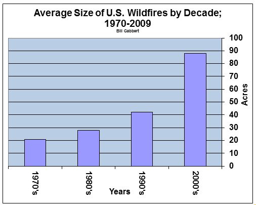
Ave size of wildfire by decade, 1970-2009

We can debate the reasons for it, but there is no question that over the last 40 years the average size of wildfires has increased. The data we collected from the National Interagency Fire Center when grouped by decade shows that the average size of fires between 1970 and 2009 has more than quadrupled.

Ave size of wildfire by decade, 1970-2009Climate Central has also noticed this and issued a report about the change in fire activity over the last 42 years. Here are some highlights:

  • The National Research Council reports that for every degree Celsius (1.8°F) of temperature increase, the size of the area burned in the Western U.S. could quadruple.
  • For the last decade, compared to the 1970s, there were 7 times more fires greater than 10,000 acres and nearly 5 times more fires larger than 25,000 acres each year.
  • Since the 1970s the average number of fires over 1,000 acres each year has nearly quadrupled in Arizona and Idaho, and has doubled in California, Colorado, Montana, New Mexico, Nevada, Oregon, Utah and Wyoming.
  • The burn season is two and a half months longer than 40 years ago.
  • Rising spring and summer temperatures across the West appear to be correlated to the increasing size and numbers of wildfires. Spring and summer temperatures have increased more rapidly across this region than the rest of the country, in recent decades. Since 1970, years with above-average spring and summer temperatures were typically years with the biggest wildfires.

In spite of this clear trend of increasing wildfires, Congress and the Administration have been reducing the budgets of the federal land management agencies, and have cut the number of large air tankers on exclusive use contracts by 80 percent since 2002, from 44 to 9. However, seven more air tankers may be added over the next year, bringing the total to 16. William Scott, a fire aviation expert who also has experience in the National Security Agency, thinks that terrorists could, and perhaps already are waging economic war inside the United State by starting wildfires which can cost the government and residents billions of dollars.

 
Thanks go out to Kelly

Video of fire tornado in Australia

Outback fire tornadoes-Australia from chris tangey on Vimeo.

Check out the strong indrafts going toward the fire vortices in this video. Very impressive.

We have written quite a few articles about fire tornadoes, sometimes called fire whirls. The more scientific name for them is fire vortices. Our posts about them can be found under the tag “fire tornado“.

Here is the description of the above video on YouTube:

==============================================================

THERE’S something mean and magical about Australia’s Outback. An Alice Springs filmmaker captured both when a whirlwind of fire erupted before his eyes.

Chris Tangey of Alice Springs Film and Television was scouting locations near Curtin Springs station, about 80km from Ularu, last week when confronted by a fiery phenomenon.

He had just finished his tour of the station when workers encountered difficulties with a grader. So he went to help them.

A small fire was burning in nearby bushland, so Mr Tangey decided to start filming.

He caught the sight of his life.

A twister touched down on the spot fire, fanning it into a furious tower of flame.

“It sounded like a jet fighter going by, yet there wasn’t a breath of wind where we were,” he told the Northern Territory News.

“You would have paid $1000 a head if you knew it was about to happen.”

The column of fire danced about the landscape for about 40 minutes, he said, as he and the station workers stood transfixed.

There was talk of making a quick getaway, Mr Tangey said. But everyone was too hypnotised to feel scared – and he continued furiously filming.

“The bizarre thing was that it rarely moved,” he said.

“These things just stood there because there was no wind to move them … but it was flickering incredibly fast.”

Darwin weather forecaster David Matthews said small twisters were common in isolated areas. But the fiery vortex was highly unusual.

“The flames would have assisted by trying to suck in air and that could have helped generate those circular winds,” Mr Matthews said.