Long Island fires, 1995 and 2012, and Senator D’Amato’s air tankers

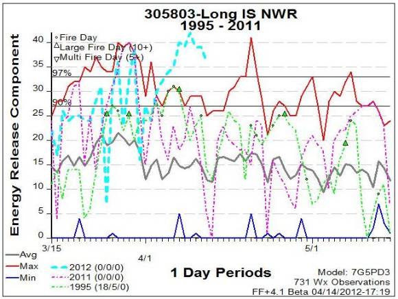
Long Island Energy Release Component

The April 9 fires on New York’s Long Island were described by Steve Bellone, the Suffolk County executive, as being “The most serious fire incident we’ve had since the 1995 wildfire”. The fire weather station near Brookhaven on Long Island, New York is setting records for extreme fire danger. As you can see in the graph above, the Energy Release Component is running extremely high this Spring, even higher than in 1995. The ERC describes how hot a fire will burn, and is related to the available energy (BTU) per unit area (square foot) within the flaming front at the head of a fire. Daily variations in ERC are due to changes in moisture content of the fuels (vegetation) present, both live and dead. More graphs showing additional fire danger indices for Long Island can be found on the Eastern Area Coordination Center’s web site.

All of this data helps to explain the nearly unprecedented fire behavior being seen on fires in the area. When we posted the video interview with the local firefighter who became entrapped on April 9 and was seriously burned, Tom Plymale commented about the recent incident:

I was on the 1995 Sunrise fire and personally saw 5 of these burned up “stumpjumpers”. What I learned from talking to locals is they got quite a few wildland fires in the Pine Barrens but they are typically small and easily handled. The lack of fire behavior training and experience during extreme burning conditions is what they lacked. After 1995, there was a group put together to try and help these folks get better training but its been 17 years and they could have a whole new generation of people there. Just my opinion.

The 1995 fire and the “CNN Drop”

The Sunrise fire in late August of 1995 burned about 7,000 acres on Long Island, exhibiting fire behavior most firefighters had never seen in that area. The fire is infamous among wildland firefighters for the battle between a U.S. Senator from New York, Alfonse M. D’Amato, and the Type 1 Incident Management Team running the fire. D’Amato called President Bill Clinton, who was vacationing in Grand Teton National Park in Wyoming, and told him that he wanted military C-130 Modular Airborne FireFighting System (MAFFS) air tankers to help put out the fire. (As a side note, that First Family vacation was in itself an Incident for the local parks and national forests, and the impacts of it were managed by a National Park Service Incident Management Team, with this author as Planning Section Chief).

After talking to the president, D’Amato held a news conference, telling reporters that the C-130s were on the way. But the IMTeam had not ordered any large air tankers, and the fires were nearing containment using only some smaller air tankers and 12 helicopters. D’Amato went to Long Island, and wearing a Fire Chief’s turnout coat, met with several high-ranking FEMA officials, Department of Agriculture executives, and the IMTeam. He was told the C-130s were not needed on the fire. The Senator vehemently insisted, and ultimately a request was placed for two C-130 air tankers from an Air National Guard base in North Carolina, along with a third plane carrying support personnel. When the aircraft arrived, the fire was contained, but an area was found that had a little grass still burning near a highway, with plenty of room for TV trucks. A C-130 was directed to drop there, but before it could release its load a warning light came on in the cockpit and it had to return to the airport. The second C-130 was ordered to make the drop on the still-smoldering grass, and it did, to the delight of the media and Senator D’Amato.

This incident may be one of the first times the term “CNN Drop” was used to describe an air tanker drop whose primary objective was to placate local residents, politicians, and the media.

Thanks go out to Tom and Midwest

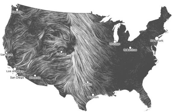
Animated wind map


Wind mapThe map above is a screen grab from an animated wind map. If you go to the site hint.fm/wind, you will see that the lines move in the direction of the wind, and the speed of the moving lines varies depending on the actual wind speed. The data is downloaded from the National Weather Service’s database every hour, so what you will see there is near real-time conditions.

It’s interesting that on the site, they advise that you: “Please do not use the map or its data to fly a plane, sail a boat, or fight wildfires 🙂 “.

Check it out. It’s mesmerizing.

You’re welcome.

(Note: when you go to the site, it takes a lot of computer horsepower to animate the map . It may not work on your smart phone, or even on your computer. They advise: “If the map is missing or seems slow, we recommend the latest Chrome browser.”)

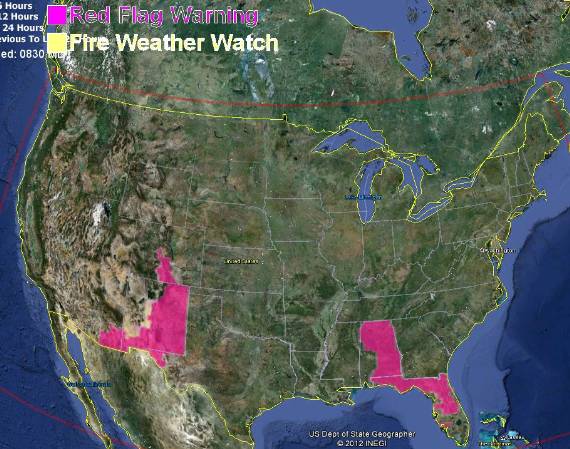
Red Flag Warnings, April 12, 2012

Red flag warnings 4-12-2012

A smaller portion of the United States is under a Red Flag Warning than in previous days. New England is out of the spotlight, and the folks living in Georgia, Tennessee, and Texas must be living right, since for the most part, their states avoided the warning today. Either that, or the National Weather Service forecasters in different regions use various criteria for Red Flag Warnings.

Red flags, prescribed fires, and cannon fire

Red flag warnings 4-6-2012
Red flag warnings April 6, 2012

The map for April 6 shows Red Flag Warnings covering large areas of the United States. And again, the map shows the warnings-constrained-by-state-boundaries-syndrome. This makes a person wonder if the forecasters on one side of the state boundary were too aggressive with their warning, or if the folks across the border were too timid, or it simply didn’t occur to them to post a warning. Or none of the above.

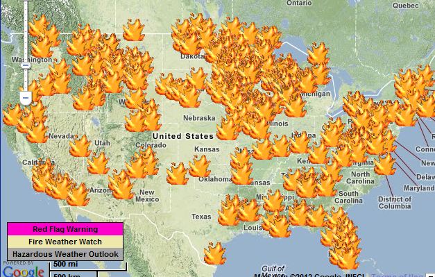
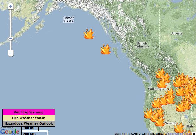
Check out the map below showing the locations of spot weather forecasts.If you go to the National Weather Service web site and click on one of the large flame icons, you’ll see that most of them are for prescribed fires —  few are for wildfires. And almost all of the prescribed fires are less than 100 acres.

Spot weather forecasts 4-6-2012
Spot weather forecasts April 6, 2012

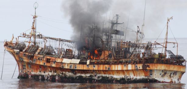
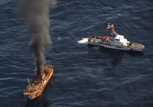
Two spot weather forecasts are for locations in the Pacific Ocean. One was for a prescribed fire near Coburn, North Dakota, and the other one, in the Gulf of Alaska, was requested by the Coast Guard. I’m thinking that the latter is for the incident involving the derelict ghost ship Ryou-Un that was set adrift during last year’s tsunami in Japan. The Coast Guard decided to use a cannon on one of their cutters to blast holes in the ship and sink it rather than risk the chance of it running aground or endangering other vessels in the busy shipping lanes between North America and Asia.

Spot weather forecasts, Pacific Ocean 4-6-2012

From the photo below, it appears that the ship took quite a few cannon rounds from the Coast Guard cutter.

Coast Guard sinks ship
The Ryou-Un is set afire after being hit by the cannon from a Coast Guard cutter. Photo by U.S. Coast Guard
Coast Guard sinks ship
Photo by Petty Officer 2Nd Class Charly Hengen, U.S. Coast Guard


Detecting wildfires using radar and satellites

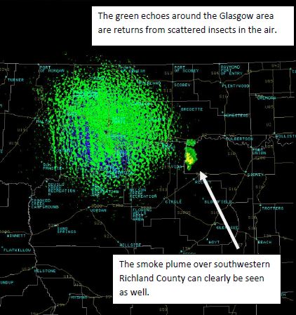
Radar image detecting wildfire smoke plumeSome employees of the National Weather Service in Glasgow, Montana have written a description of how on April 3, 2012 they detected two fires using radar and satellite imagery. Below are some excerpts from their document, which was the source of the two images displayed here.

…As our forecasters were working during the day on April 3rd, they noticed some plumes on satellite imagery, on a day where there weren’t any clouds for hundreds of miles in all directions. They called Richland County dispatch to check and see if there were any fires, and were notified that there were at least two fires, one in southwestern Richland County, the other in northeastern Dawson County.

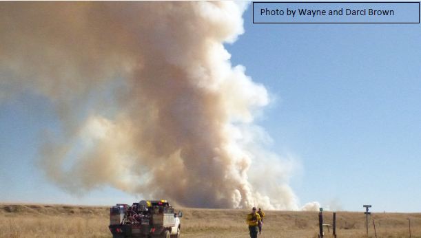
As the day warmed up, the winds increased from a southerly direction, and the humidity dropped from around 68% at 8 am to below 20 percent after 1 pm. According to Rob Gilbert with the Sidney fire department, an area that had been burned during the weekend had reignited and quickly grew out of control as the winds blew the top layer of ash off the old burn. In all, the southwest Richland County Fire burned at least 1000 acres of land, and two abandoned farmsteads, northwest of Richey, MT.

The smoke plume from the Richland County fire was high enough that we were able to detect it on the Glasgow weather radar. The fire was located about 75 miles east-southeast of the radar, and at that distance, the lowest level of the radar beam (0.5 degrees) would put the radar beam at around 7,500 to 8,000 feet AGL. So, the smoke plume rose at least 1.5 to 2 miles high in the atmosphere.

Photo of wildfire smoke column in Richland County, Montana


Red flag warnings for New England

Red flag warnings 4-4-2012
Red flag warnings April 4, 2012

It is unusual to see Red Flag warnings for the New England states, but today the list includes most of southern New England — portions of: NH, VT, MA, RI, CT, NY, as well as parts of the western states of NV, AZ, NM, TX,  MT, ND, and SD.

Here is an example of one of the warnings issued by the National Weather Service, in this case it is for western Mass.:

============================================================

RED FLAG WARNING IN EFFECT FROM 11 AM THIS MORNING TO 8 PM EDT THIS EVENING FOR MUCH OF SOUTHERN NEW ENGLAND…

THE NATIONAL WEATHER SERVICE IN TAUNTON [MASS.] HAS ISSUED A RED FLAG WARNING FOR MUCH OF SOUTHERN NEW ENGLAND…WHICH IS IN EFFECT FROM 11 AM THIS MORNING TO 8 PM EDT THIS EVENING. THE FIRE WEATHER WATCH IS NO LONGER IN EFFECT.

  • AFFECTED AREA…ALL OF SOUTHERN NEW ENGLAND EXCEPT FOR CAPE COD AND THE ISLANDS.
  • WINDS…NORTHWEST 10 TO 20 MPH WITH GUSTS UP TO 30 MPH.
  • TIMING…FROM LATE MORNING THROUGH EVENING.
  • RELATIVE HUMIDITY…AS LOW AS 13 PERCENT.
  • TEMPERATURES…IN THE UPPER 50S TO MID 60S.
  • IMPACTS…ANY FIRES THAT DEVELOP WILL LIKELY SPREAD RAPIDLY. OUTDOOR BURNING IS NOT RECOMMENDED.

===============================================================

Be careful out there New Englanders.