The National Weather Service in southern California is changing the criteria that triggers a red flag warning for fire danger. In addition to wind speed and relative humidity, the new system will take into account local geography and terrain. Weather forecast offices across the state will have different criteria. Check out the full story in the LA Times, but here is a video of an LA Times reporter explaining the new system.
Tag: weather
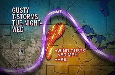
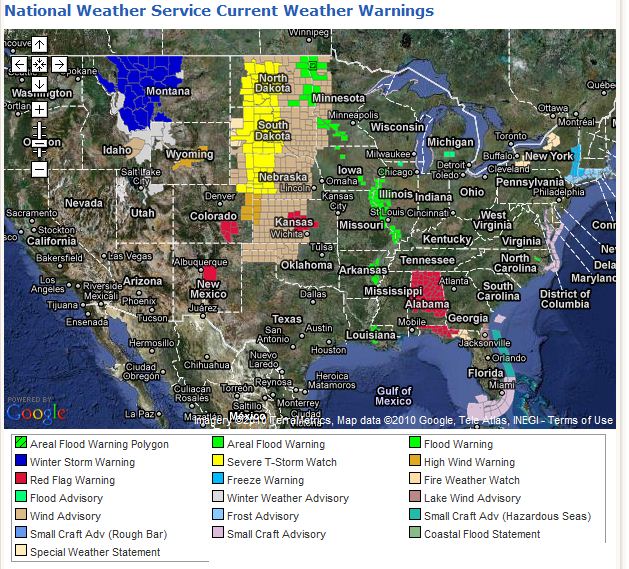
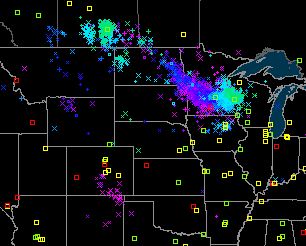
Interesting weather for the north-central US
Wildland fire air quality tools, and mapping shortcuts
I ran across an interesting web site the other day called Wildland Fire Air Quality Tools. It has some very useful devices for predicting and analyzing smoke, wind patterns, and air quality.
There is no obvious branding on the site (the base web address is http://firesmoke.us), but the Contact Us page lists two US Forest Service employees, Pete Lahm and Sim Larkin. The About This Site page says:
The meteorological and air quality tools provided here are intended to support wildland fire decision making and integration of air quality assessments. This site integrates these tools with the Wildland Fire Decision Support System (WFDSS) in order to enable easy workflow with WFDSS. This integration is still in development and ongoing.
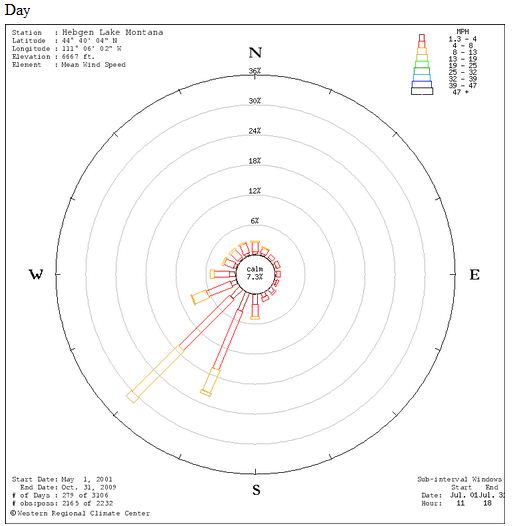
One of the more interesting tools on the site is one that will display a “wind rose” based on the location of your choice. If you enter a lat/long it will access data from the nearest RAWS to draw wind roses for a one month period, one for daytime and another for night. As you may know, a wind rose shows the historic wind direction and speed. Here is an example for West Yellowstone, Montana. It shows average wind speed and direction for the month of July during the day, based on data from 2001 to 2009. About 32% of the time the wind is from the southwest and about 22% of the time it’s from the south-southwest. About 14% of the time the wind speed is 8-13 MPH from the southwest.
Mapping shortcuts
You will need a lat/long to use the tools above, but you’re in luck because I discovered a quick way to determine the lat/long anywhere using a new “Labs” feature in Google Maps. But first I’ll tell you about another new feature in Google Maps that will help you navigate more quickly to a specific location.
On the Google Maps page, click on “New” at the top of the page. It will then list some new optional features in “Google Maps Labs”. If you Enable “Drag ‘n’ Zoom“, you can drag your mouse cursor to draw a box, then it will zoom to that box. To use this feature, click on the new magnifying glass icon that will appear on the left side of the map page under the “+” and “-” scale bar. Each time you want to draw a box to zoom, you’ll need to click that icon again.
Then scroll down in the Labs options and Enable “LatLng Marker” (not LatLng Tooltip). Click Save Changes. This option will post a “mini marker” showing the lat/long when you right-click on the map and choose “drop LatLng Marker”.
You’re welcome.
Snowfall does not determine fire season severity in Alaska
When I am asked to predict the severity of the next wildland fire season, I usually say: “Ask me in August and I’ll have a better answer”. If the weather during the fire season is hot, dry, and windy, you will have a busy fire season. If it is not, you won’t.
That is basically what meteorologists in Alaska are saying when they are asked about this winter’s weather which produced one of the lowest snowfalls there in the last 100 years. Here is an excerpt from an article in the News Miner:
FAIRBANKS — The lack of snow this winter doesn’t mean more wildfires this summer.
Despite one of the lowest snowfalls on record in more than 100 years, weather experts say summer weather, not the winter’s snow accumulation, will dictate what kind of fire year Alaska has in 2010.
Studies by the Alaska Fire Service in Fairbanks and fire experts in Canada show there is no relation between winter snowfall and summer fire danger, she said.
“It has more to do with the weather during the fire season,” Sharon Alden, a meteorologist at the Alaska Fire Service, said. “We could have a really low snow year and a really dry spring and then it rains the rest of the summer.”
Meteorologist Mike Richmond, who specializes in fire weather at the National Weather Service in Fairbanks, agreed.
“In the boreal forest of Alaska and Canada there is no relationship between winter snow pack and summer fire danger,” he said.
For example, during the winter preceding Alaska’s biggest fire season on record in 2004, when more than 6.7 million acres burned, Fairbanks received
62.2 inches of snow, which is only about 10 inches below normal.
“We had a near average snow pack and we had our worst fire season ever,” Richmond said.
The picture was much the same the following year, when approximately 4.7 million acres burned after an above-average winter snowfall of 77.4 inches.
Conversely, only 28 inches of snow fell at Fairbanks International Airport during the winter of 2006-07, the third lowest snowfall total on record since 1904, but only 550,000 acres burned in the summer of 2007.
Last winter, Fairbanks received 71.5 inches of snow and approximately 2.95 million acres burned last summer.
With only 24.8 inches of snow as of Friday, Fairbanks is on track for one of its lowest winter snow accumulations since the National Weather Service began keeping records in 1904.
Up to this point, there have been only two winters — 1918-19 with 12.0 inches and 1952-53 with 22.9 inches — in which Fairbanks has recorded less snow than this year.
Fairbanks is experiencing one of its driest winters on record, Richmond said. Only 4.54 inches of precipitation has been measured at Fairbanks International Airport since the start of July.
“This is the fourth-driest period in Fairbanks recorded history from July until now,” Richmond said. “We are in a drought basically.”
But it’s a matter of how dry it is in May, June and July that dictates what kind of fire season Alaska will have.
“It’s all short-term weather process driven,” Richmond said. “If we have rains every two or three weeks or closer together, we don’t get a fire season.
“We have to have periods of three weeks or longer of dry weather for there to be a fire season (in Alaska),” he said. “When we get a dry season, that’s when we get the fires.”
Contribute weather reports to the NWS
The National Weather Service is experimenting with a system that will enable anyone with a Twitter account to submit weather reports from their cell phone or computer. The primary purpose is to collect “storm reports” or “significant weather reports”.
As long as the reports are formatted as prescribed by the NWS, the data, or the individual messages or “Tweets”, will be searchable and available to anyone who visits twitter.com or uses a 3rd party Twitter application on their computer (such as TweetDeck) or on their cell phone (such as TwitDroid, for Android-based smart phones).
To send a Twitter message or “Tweet” with a storm report or a significant weather report, it must be in this format:
#wxreport WW <your location> WW <your signifcant weather report>
The key is to use the searchable “hash tag” of “#wxreport”, then put “WW” both before and after your location, separated by a blank space. And after that goes your weather information.
The location can be an address, lat/long, airport identifier, city/state, or zip code.
If your cell phone has a GPS receiver and your 3rd party Twitter application has the ability to Geotag messages with your lat/long, then it’s even easier, but both your cell phone AND your Twitter account settings have to have geolocation enabled. Here is the format if your message is geotagged:
#wxreport <your signifcant weather report>
Anyone can go to twitter.com and search for #wxreport, even if you don’t have a twitter account.
According to the NWS:
Once an office decides that a posted report is reliable and applicable, it will be added to a Local Storm Report. LSR reports are available both via RSS feed and web pages directly from NWS web sites.
I found a web page for NWS Storm Reports, but even though there is a major winter storm affecting the central part of the United States today, the page contained no reports. Maybe I was looking in the wrong place.
More information about the system can be found HERE.
Wildfire news, November 24
Los Angeles County Fire Chief announces retirement.
P. Michael Freeman today announced that he will be retiring in March, 2010. Chief Freeman has served as Fire Chief with the Los Angeles County Fire Department LACFD for 21 years.
On November 18 the LADFD issued a report about the Station fire that lobbed some criticism towards the U. S. Forest Service for their management of wildland fires.
NASA’s Predator UAV flies burn sites in California
NASA provided this information in a press release:
====================
MOFFETT FIELD, Calif. – NASA’s remotely piloted Predator B aircraft, named Ikhana, recently conducted post-burn assessments of two Southern California wildfire sites, the Piute Fire in Kern County and the Station Fire in the Angeles National Forest. Ikhana, an unmanned aircraft equipped with an infrared imaging sensor, completed a seven-hour imaging flight on Nov. 19, 2009 from NASA’s Dryden Flight Research Center, Edwards Air Force Base, Calif.
The Autonomous Modular Scanner, developed by NASA’s Ames ResearchCenter, Moffett Field, Calif., was carried in a pod under the aircraft’s wing. The scanner operates like a digital camera with specialized filters to detect light energy at visible, infrared and thermal wavelengths.
The scanner operated with a new photo mosaic capability requested by the U.S.Forest Service. A photo mosaic provides easier interpretation for the end user, which in the case of an active wildfire, is the fire incident commander.
Traveling northwest of NASA Dryden, the aircraft flew several data collectionroutes over the area burned by the month-long Piute Fire in Kern County that grew to 37,026 acres before it was contained in July 2008. The burn area is located in the Sequoia National Forest and on Bureau of Land Management public land near Lake Isabella.
Ikhana then traveled southeast to fly image collection routes over the arson-caused Station Fire. It burned more than 160,000 acres in the Angeles National Forest northeast of Los Angeles after being ignited on Aug. 26, 2009. The scanner collected images that will indicate the severity of devastation within the fire area. Another use of the images is for the U.S. Forest Service’s Burned Area Emergency Rehabilitation, or BAER.
The Forest Service uses BAER to reduce further damage to land made unstable by fires, rather than replace what is burned. The BAER data are derived using multi-spectral data available from the Autonomous Modular Scanner on the aircraft. The processes can be changed mid-mission to enable improved collection of critical information, either in mapping active fires or assessing post-burn severity.
The post-burn images collected by the scanner were transmitted through a communications satellite to NASA Ames, where the images were superimposed over Google Earth and Microsoft Virtual Earth maps to better visualize the locations. The images then were made available to the Forest Service for initial assessment of the damage caused by the fires and rehabilitation required.
Scientists prove mega-droughts occurred
By studying mineral deposits in caves, scientists have proved that extended droughts, or “mega-droughts” have occurred hundreds of years ago. The researchers took core samples of deposits left by dripping water in caves, and studied them much like scientists study tree rings to determine fire history.
Their analysis in caves in the Sierra Nevada in California determined that one of the droughts they detected lasted 140-years around the year 1100. The pattern of droughts seems to be associated with rapid climate warming.
Bushfires wreaking havoc in Australia
From The Trumpet:
Thousands of homes are threatened by huge wildfires sweeping across eastern Australia. Record temperatures and persistent winds have combined to make this the worst bushfire threat in 100 years in New South Wales, just months after the country’s most devastating wildfire disaster to date.
The record heat has kindled fears of a repeat of February’s cataclysmic fires in Victoria that killed 173 people and consumed more than 2,000 homes. The conditions have prompted authorities to issue the first “catastrophic” or “Code Red” alert—a new level of warning introduced since the deadly Black Saturday fires in February—for parts of New South Wales and South Australia.
“The very hot temperatures we’ve seen across New South Wales right throughout this last week are simply breaking hundred-year records,” said Rural Fire Service Commissioner Shane Fitzsimmons.
In a Code Red warning, residents cannot be forcibly evacuated, but are strongly advised to leave their property because of the dire risk of death, injury and destruction.
Fire expert Kevin Tolhurst said, “What we saw on (Black Saturday) was an extraordinary day from a weather point of view. We are starting to see those sort of days more frequently.”
Bill introduced in Senate to aid in control of pine beetles
From KPVI news:
U.S. Sen. Mark Udall says the insect infestation killing millions of pine trees in the West is 1 of the region’s “biggest natural disasters.”
The Colorado Democrat said Monday he has introduced a bill to give forest managers more ways to respond.
The bill, co-sponsored by Republican Sen. Jim Risch of Idaho, would allow the U.S. Forest Service to identify high-priority areas and expedite analysis of proposed treatments.
More than 2.5 million acres of pine trees in northern Colorado and southern Wyoming have been killed by tiny beetles that burrow under the bark.
Forest managers say the outbreak poses wildfire and public safety risks.
A national management team will help the Forest Service coordinate responses to the outbreak.
As we reported on November 11, one of the NIMO teams has been activated to assist in battling beetles.
Fewer inmates could hamper fire suppression in California
The state of California is under a court order to reduce their prison population by 40,000 people, from 150,000 to 110,000. In order to comply, Governor Schwarzenegger is seeking legislation to implement alternatives to state incarceration, such as house arrest or utilizing local jails.
A reduction of this size in low risk inmates will mean there will be fewer prisoners available to staff the state’s Type 2 inmate crews. When working on a fire an inmate earns $1 per hour, much less than a CalFire employee, so replacing the crews with CalFire firefighters is not an option in a state with major financial problems.
The reason the court ordered a reduction in the prison population was to improve the treatment of physically and mentally ill inmates. They labeled the care so poor that it violates an inmate’s constitutional rights.


