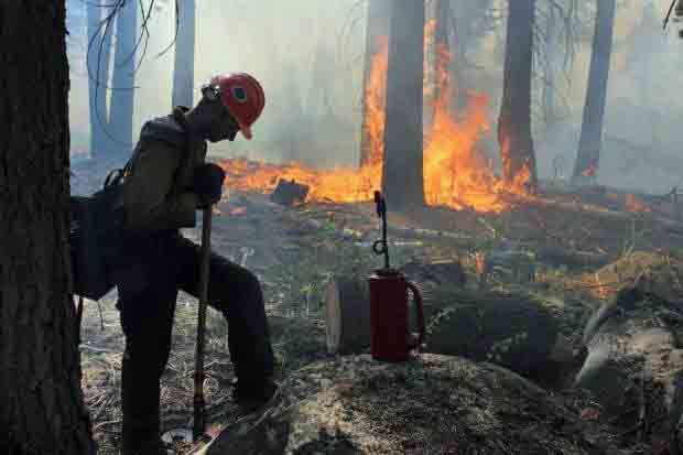
Firefighter and a fire-scarred Giant Sequoia. Still image from the NPS video.
We are pleased to see that some federal agencies, especially the National Park Service, are producing professional-quality films that interpret for the general public the science of wildland fire. We have written previously about successful video projects produced by Everglades National Park, and now Yosemite National Park has released their second film about the science of the 2013 Rim Fire that burned 254,685 acres in and near the Park. Their first one featured Fire Ecologist Gus Smith, and a second with the inspired title of “Rim Fire” was uploaded today on YouTube. It is embedded below and emphasizes the importance of reintroducing fire into the forest while treating your eyes to excellent photography.
Kate Wilkin describes this video that illustrates the fire history in Yosemite National Park in Southern California:
Once fire is restored as an ecosystem process, fires often fit together like a jig saw puzzle or overlap slightly. Where fires overlap, they sometimes moderate how many trees are killed by the fire. However, if a fire kills most trees, then following fires continue to kill many trees. These findings are from the Wildland Fire Use program, such as in
Yosemite National Park’s upper mixed conifer forests in the Illilouette Creek Basin—a nearly 50 year experiment allowing 150+ lightning strike fires to burn in Yosemite’s wilderness. Here, the fire frequency and effects are approaching historical forest conditions. These results, which reduce fire hazards for people and nature, could be seen in similar forests elsewhere in California if fire became a principle tool of forest management.
Video by Kate Wilkin and Shannon Fairchild from the Stephens Wildland Fire Science Lab at the University of California at at Berkeley. The map is projected in UTM 11N NAD 83. Fire history polygons from Yosemite National park.
Ms. Wilkin is a graduate student at Berkeley’s Department of Environmental Science, Policy, and Management. She elaborates on her work HERE.
In 2015 Yosemite National Park celebrates their 150th year.
A fire near White Salmon, Washington in the Columbia River Gorge damaged three residences Thursday afternoon. The spread of the Copper Fire was stopped at 10 acres and it was almost contained by 9 p.m. Thursday.
Bears are a problem on the fire in Yosemite
Firefighters on the Meadow Fire in Yosemite National Park in California are having to deal with bears as well as the fire. The critters are described as a “major issue” for the safety of fire crews that are staying overnight in spike camps in remote areas near the fire. Measures are being taken to not attract bears to the food and other supplies. Trash is being backhauled daily.
The Meadow Fire started on July 19 and was monitored but not suppressed until it grew substantially on September 7. It is now 4,906 acres and the incident management team is saying it is 50 percent controlled.
Slow wildfire season saves Montana money
The wildfire season that has been much slower than normal in Montana has led to the lowest spending on firefighting in a decade. The number of acres burned in the state this year has been 12 percent of the five-year average. The $1.7 spent so far leaves about $44 million in the fire suppression fund that will be available to use next year.
New system to determine fire danger during Santa Ana winds
The U.S. Forest Service has worked with San Diego Gas & Electric and UCLA to develop a new system to calculate localized fire danger during the strong Santa Ana wind events that typically blow across southern California during the last months of the year. In addition to considering the typical inputs such as temperature, wind speed, relative humidity, and vegetation moisture, the “Fire Prep” program will also analyze the history of each target area over the previous 30 years. The USFS plans to send alerts designed to help fire agencies, other emergency responders and the public take appropriate action based on the threat level.
The system will be unveiled on September 17.
Nine naturally occurring eternal flames
An article at mnn.com lists and has photos of nine sites around the world that have naturally occurring fires burning almost non-stop – many of them for centuries. Most of the fires are fueled by natural gas or methane. There are dozens or hundreds of underground coal fires burning that are not listed, but those are typically difficult or impossible to see or photograph.
Lava flow less than half a mile from subdivision
The lava flowing from the Kilauea volcano in Hawaii is now less than half a mile from the Kaohe Homestead subdivision boundary.
Target practice banned in some areas of California during drought
Excerpts from the Ramona Home Journal:
Cal Fire recently announced restrictions on recreational shooting of guns on public lands due to the extreme risk of wildfire that can result from discharging weapons during the current dry conditions.
Shooting is restricted by County Code when the California Department of Forestry proclaims a “high fire hazard,” which it did on June 20, 2014, making it unlawful for any person to discharge a firearm within State Responsibility Areas until the proclamation is lifted.
According to Cal Fire, there has been an increase in fires caused by recreational shooting across San Diego County, including the General Fire in 2013, and the Border Fire last month. Fire suppression costs for shooting-related incidents in San Diego County cost taxpayers more than two million dollars a year. The announcement from the agency also cited the Health and Safety Code, which states that persons who are responsible for starting a fire will be liable for the costs resulting from that fire.
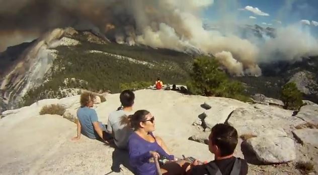
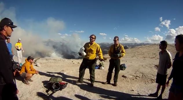
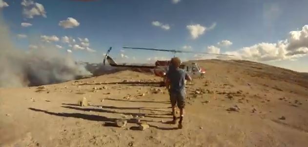
When Shelby Seabaugh began her hike to the top of Half Dome in Yosemite National Park in California on September 7, she had no idea she would be flown off the mountain in a helicopter. This video documents her adventure that day.
When she reached the top, the Meadow Fire burning east of their location caused Park officials to decide that all 85 of the hikers on Half Dome would have to be evacuated by helicopters.
Four agencies supplied the ships that hauled the hikers off the mountain: the California Highway Patrol, U.S. Forest Service, Sequoia & Kings Canyon National Parks, and CAL FIRE.
If you are not inclined to watch the entire 17-minute video, which includes the hike from the bottom to the top, and the helicopter ride back down again, you can start at about 10:30 which is when the group was near the top and includes some interesting views down onto the Meadow fire. At 11:30 it appears that helitack personnel are briefing the hikers about their upcoming helicopter ride.
The spread of the Meadow Fire in Yosemite National Park in California has slowed, but still grew by about 100 acres on Tuesday to a total of 4,500 acres. As predicted, sunny weather and much lower relative humidity enabled some spot fires to become more active. There was also some isolated crowning and torching. On Wednesday the weather will be similar, but with stronger winds gusting up to 15 mph out of the west in the afternoon.
Firefighters are staying overnight in spike camps at several locations to reduce helicopter flights into the wilderness, but helicopters are being used to support crews with water drops. The highest priority is to secure the west flank to allow the trail to Half Dome to open.
The National Park Service has settled the issue of the origin of this fire, writing on InciWeb that it was an expansion of the fire that had been monitored since July 19, exacerbated by a wind event, rather than it being a new fire that started on Sunday.
3-D Map of the Meadow Fire at 11 p.m. September 8, 2014. Looking east. Half Dome can be seen in the center of the image, between Yosemite Valley and the fire. (Click to enlarge.)
The Meadow Fire in Yosemite National Park has grown to about 4,400 acres and was still very active when it was mapped Monday night. Rain showers passed through the area Monday morning but the precipitation may have evaporated before much of it hit the ground, since a weather station in Yosemite Valley did not detect any rain. Another weather station about 12 miles northwest of the fire measured 0.07 inches.
The Meadow Fire was first reported on July 19 but was not suppressed. It had spread to cover 19 acres while it was being monitored, until Sunday, September 7 when it began to grow rapidly pushed by a very strong wind.
On Sunday 85 hikers and climbers were evacuated from the summit of Half Dome by helicopters from the California Highway Patrol, U.S. Forest Service, Sequoia & Kings Canyon National Parks, and CAL FIRE.
High humidities assisted firefighters on Monday, slowing the spread of the fire, but the RH will lower into the 20s on Tuesday and no rain, in fact no clouds, are in the forecast for several days.
Cooper’s Type 2 Incident Management Team assumed command of the fire Monday. No information about the fire has been posted on InciWeb, however we found some updates on Facebook and the park’s website.
Map of the Meadow Fire at 11 p.m. September 8, 2014. North is up. (Click to enlarge.) Half Dome reaches above the smoke created by the Meadow Fire, as seen from Sentinel Dome at 8:51 a.m. PDT, 9-9-2014.
****
(UPDATE at 5:11 p.m. PDT September 8, 2014)
The NPS announced Monday morning that the fire in Yosemite has been mapped at 2,582 acres, up from the 700 acres reported late Sunday.
This time-lapse video of the fire is fascinating. It gets better at 0:21 after the camera is moved out of the bottom of the valley.
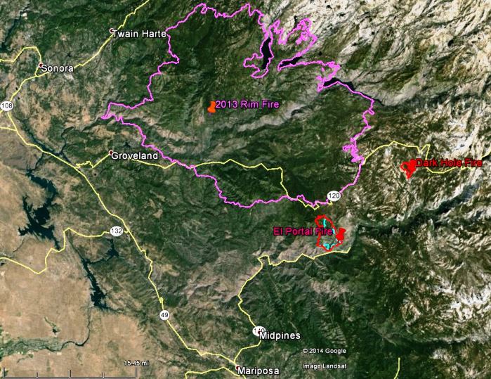
Map of the El Portal and Dark Hole Fires, 11:45 p.m., July 30, 2014 (click to enlarge)
The map above shows the perimeters, in red, of the El Portal and Dark Hole Fires in Yosemite National Park. The blue line was the perimeter of the El Portal fire about 48 hours earlier. The 2013 Rim Fire can be seen north of those two fires.
The El Portal Fire added another 300 acres on Wednesday when it ran for over half a mile in the Crane Creek area, bringing the total to 4,200 acres.
There was rain on the Dark Hole fire on Wednesday, allowing only an additional 11 acres of growth.
Approximately 1,063 personnel are assigned to the fire.
As of Wednesday night, the Big Oak Flat Road (Highway 120) in Yosemite National Park has been reopened to vehicular traffic. The road was temporarily closed due to fire activity related to the El Portal Fire. All other roads within the park, including the Tioga Road, are open and clear, with the exception of the Foresta community access road, which remains closed. Crane Flat, Yosemite Creek, and Bridalveil Creek Campgrounds remain closed. All other park campgrounds are open.
****
(UPDATED at 7:10 a.m. PDT, July 30, 2014)
The El Portal Fire outside the entrance to Yosemite Valley in Yosemite National Park has burned about 3,545 acres and the incident management team is calling it 34 percent contained. Over the last 24 hours the fire was very active on the north side.
Big Oak Flat Road is still closed and the community of Foresta remains under an evacuation notice. The fire is threatening the Merced Grove of Giant Sequoias in the park.
To see a much larger image, click the full screen icon at bottom-right.
This video is a collaboration between Sheldon Neill and Colin Delehanty. All timelapses were shot on the Canon 5D Mark II with a variety of Canon L and Zeiss CP.2 Lenses.
A 200+ mile backpacking experience through Yosemite National Park captured by Colin Delehanty and Sheldon Neill. This project was filmed over the course of 10 months. They spent a combined 45 days in the park capturing the images in this video.
This is an excellent virtual tour video that shows the geographical relationship of the 187,000-acre Rim Fire to Yosemite National Park, Yosemite Valley, and some of the other landmarks in the area.
A crewmember of the Horseshoe Meadows Hotshots, on the Rim Fire, September 2, 2013. USFS Photo by Mike McMillan.
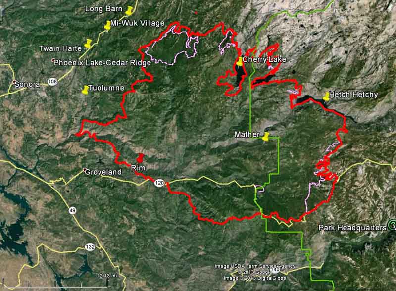
Firefighters have made some progress on the Rim Fire since our last update on September 4. As you can see in the map below, the fire has grown very little in the last six days, and most of the change in the fire perimeter is most likely a result of firefighters burning out the vegetation ahead of the fire.
Map of the Rim Fire. The red line was the perimeter at 1 a.m. PDT, September 10, 2013. The pink line was the perimeter at 9 p.m. PDT, September 3, 2013. The western boundary of Yosemite National Park is shown in green. (click to enlarge)
The fire has burned 254,685 acres and the incident commander is calling it 80 percent contained. Over 3,000 personnel are assigned to the incident, down from more than 5,000 a week or so ago. Over the last 24 days since it started, the costs for suppressing the fire has grown to $100.4 million.
****
(UPDATE at 6:50 a.m. PDT, September 4, 2013)
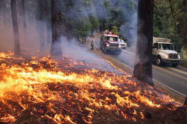
Rim Fire burnout, September 1, 2013. Photo by Mike McMillan.
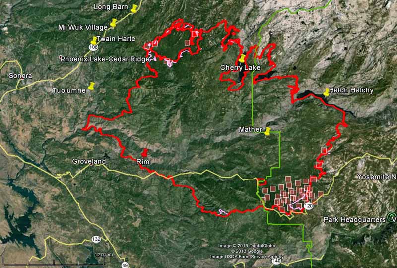
As shown in the map below, the spread of the Rim Fire has slowed considerably over the last several days. Most of the acreage increases are a result of burnout operations out ahead of the fire, sometimes miles from the fire’s edge, in order to remove the fuel, eventually stopping the spread. The west and southwest sides of the fire have been very quiet for a few days. The only significant movement of the fire which may not be related to burnouts are on the east side, with most of it being in the Cherry Lake area. On the southeast flank firefighters have selected Highway 120/Tioga Road as their fireline and are burning out along the north side.
The fire has burned 237,341 acres and the incident commander is calling it 80 percent contained. Another 3,000 acres and it becomes the third largest fire in California history.
Map of Rim Fire. The red line was the perimeter at 9 p.m. PDT, September 3, 2013. The pink line was the perimeter about 48 hours before. The red squares represent heat detected by a satellite at 10:40 p.m. PDT September 3, 2013. The boundary of Yosemite National Park is shown in green. (click to enlarge)
The strategy and tactics employed by the firefighters appear to be working. Instead of choosing the NEXT ridge for a fireline or burnout, they are selecting the BEST ridge, or sometimes a road, as the place to make their stand. This gives them enough time to execute what can be a miles-long burnout operation, and allows them some flexibility to conduct it at a time when the weather is favorable. These tactics have been used successfully on some very large fires on the Los Padres National Forest, including the Whitewater-Baldy, Basin Complex, Indians, Iron Alps, and Zaca fires.
There are currently no mandatory or advisory evacuation orders effective in Mariposa County. The evacuation advisory has been lifted for Ponderosa Hills and areas east, along the south side of Highway 108 up to Pinecrest. Highway 120 at the Yosemite National Park boundary west to Buck Meadows remains under evacuation.
Briefing at Rim Fire, September 2, 2013. Photo by Mike McMillan.