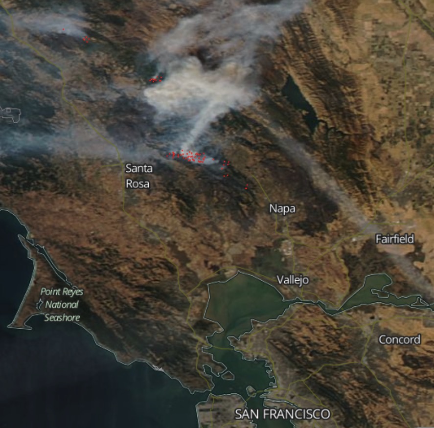
Above: Map showing the perimeters of the Pocket, Tubbs, Nuns, and Atlas Fires in northern California. CAL FIRE October 15, 2017.
(Published October 16, 2016)
Firefighters in Northern California are having some success on portions of the four largest wildfires near Geyserville, Santa Rosa, and Napa. However winds out of the southwest on Sunday caused the fires to spread on the northeast sides on all of the fires except the Atlas Fire which has been much quieter than the other three for the last two days.
Officials say 102,000 residents were either evacuated or had no homes to return to Saturday and Sunday in Sonoma County. Some evacuations were lifted late Sunday. Less than 2,000 stayed in evacuation centers.
The fires in Sonoma and Napa counties have destroyed 3,947 structures. Approximately 4,230 personnel are fighting the blazes.
Officials report that 40 people have been confirmed dead in Northern California fires over the last week including fires in Mendocino County and near Yuba City.
- Pocket Fire: 11,889 acres north of Geyserville. It continues to grow to the east and northeast.
- Tubbs Fire, 44,481 acres. The most active area of the fire is still the northeastern portion around Red Hill and Mount Saint Helena. It continues to make short uphill runs on the north side of the peaks.
- Nuns Fire, 48,627 acres. The northern portion 6 miles north of Calistoga grew to the north Sunday.
- Atlas Fire, 51, 057 acres. It is much quieter than the other three fires.

The National Weather Service predicts hot and dry conditions for the Santa Rosa area Monday with a high of 88 degrees, relative humidity in the mid-teens, and west or southwest winds of 2 to 9 mph.
Tuesday should bring better conditions for firefighters; 81 degrees, 28 percent RH, and southwest winds at 3 to 11 mph.


Thanks for all the good information. Nice work, very helpful.
Some thoughts. It’s a bit disconcerting to see the map of the communities along 128 and 29, sandwiched like that between the two big fires. The totality of the structure destruction last week – homes especially – seems to show the cheapness of modern construction that’s all ‘look’ but no substance. The communities went up like mushrooms but have been burning down like prairie grass. Terrible. Even the ‘stone’ columns are fake – patterned cement over a hollow plywood frame so they fell over, burned inside. Wonder if after this tough phase finally ends that there will be a serious action on building codes. It’s earthquake region, too, so all stone or all cement isn’t safe either, but maybe for the the first four feet of height on the ground floor plus a metal roof? Even just a metal roof might have saved many homes. Cost of course is a problem, but the big sub-divisions – since they are so packed together – perhaps should be required to be made out of something less ignitable than decorated plywood. Cinderblock isn’t that expensive. They’re all going to have to be rebuilt, this would be the time. Maybe it’s cheaper to redo the same thing; the builders will have all the business they want and more, but surely some basic practical fixes that improve structural resistance to wildfire could be incorporated during rebuild to improve the safety of the occupants. Particularly for the ‘interface’ areas where a first line of better-built structures might help protect against wildfire advancing into neighborhoods.
The construction method called Insulating Concrete Form (ICF) is fast to build with, fireproof, nearly soundproof, excellent R-value, and rot-proof. It costs more, but in a fire zone, what’s keeping your home worth? The Achilles heel is the roof and under the eaves if the ICF home still has wood trusses, but both of those are solvable problems. I closed all of my soffits (under the eaves) with fireproof Hardipanel ( a brand of cement-silica-cellulose fiber board), and not only does it look a lot better, it really improves my peace of mind living in fire country.
I wholeheartedly agree ! In todays highly enlightened & technological age, homes should be built with proper consideration of the people that will live there, with their protection in mind according to the climate and potential of natural disasters of the regions. People lives are worth the effort and expense to build a fortress against fires, earthquakes, hurricanes, floods and the like regardless of the cost. Our great nation is equipped with the resourses and knowhow to make our homes safer. Hopefully this latest fire disaster (as well as all the recent devastating hurricanes) will be a wakeup call for the government and building industry to enact stricter building codes. After some of the earthquakes in Italy, the homes were required to be constructed of solid concrete walls at least 1 foot thick. Proper precautions must be taken to begin the rebuilding process. Otherwise people will once again be living in fear.
The common sense of man in these times is a bit thin as we look at the lack of the old Indian’s use of fire to thin out the forests of excess latent fuel, and because of this, many of our forests that surround a high number of nice homes in this great USA are an accident waiting to happen. When it comes to metal roofs and concrete walls to attempt to avoid or survive the intense potential heat that is stored up in our forests, you will see what happened here in the 2015 Lake County Valley Fire to this type of structure, the fancy windows didn’t with stand the inferno that at times melts glass and metal. Wind and fuel combined, plus a little spark can equal disaster. It might be time to have our fire fighters get involved in well planed, timely, seasonal control burns when the heat and smoke is predicted to rise. We do planned control burns here on our ranch in N. Calif. But the officials seem to be more interested in clear air, and this is foolishness as we have recently experienced. Why we don’t have a fleet of old B52’s that fly above the smoke of a fire as rain creators, to wet just in front of a blaze? The 52’s equipped with stingers to scoop up lake or ocean water, for quick turn arounds with out having to land.
why does redwood valley fires and mendocino county always get the shaft
To paraphrase Ben Franklin, They who would give up essential fire safety for temporary air quality will get neither. The people who thought they could forever avoid breathing smoke by not allowing prescribed burns are now collecting the result of their policy: choking on the smoke from decades of fuel load accumulation, along with a nightmarish dose of death and destruction.
I walked some woods here in Oregon yesterday that I first set foot in 25 years ago. It badly needed a cleansing fire then; it needs one even worse today. When the part of our land management budget that deals with fire is roughly balanced between fire suppression and prescribed burns, we will have entered a new era of improved fire safety AND more beautiful wildlands. But we will breath some smoke to get there.
WELL SAID!