Wildfires: Attorney General says PG&E could face murder charges

Depends on which charges, if any, are filed by county district attorneys for causing wildfires in 2017 and 2018

In a brief submitted to a federal court, the California Attorney General wrote that Pacific Gas & Electric could be prosecuted for murder, manslaughter or lesser criminal charges if investigators determine that “reckless operation” of its power equipment caused any of the wildfires in which people were killed during the last 15 months.

Gavel

A dozen of the fires that started in Northern California around October 8, 2017 have been blamed on PG&E’s electrical equipment, according to CAL FIRE Investigators, who also are looking into power line equipment failures that may have caused the Camp Fire on November 8, 2018. Over 40 people died in the Northern California fires, and 86 perished in the Camp Fire. More than 14,000 homes were destroyed in the Camp Fire.

Shortly after both events the stock price of PG&E dropped precipitously, sinking 66 percent over the 13-month period. It took several days in 2017 for word to spread that the company appeared to be liable for the Northern California fires, but the sell-off began the day after the Camp Fire started in 2018. Investors are worried that the utility could be on the hook for billions of dollars in civil damages in addition to criminal penalties.
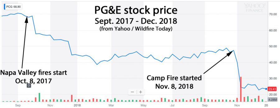
Stock price PG&E california fires wildfires liable

Below is an excerpt from the Sacramento Bee:

The legal brief submitted by [Attorney General Xavier] Becerra’s office said prosecutors would have to gauge PG&E’s “mental state” before determining which charges, if any, to bring. The charges would range from murder to a misdemeanor negligence charge, according to the brief. Becerra’s brief is purely advisory; if any criminal charges are filed, they would likely be lodged by county district attorneys, not the state.
So far, though, district attorneys have shown little appetite for prosecuting PG&E, according to Sacramento Bee reporting. No charges have been filed yet in the wine country fires. And at least one DA has opted for a financial settlement in lieu of criminal prosecution

One year later, looking at the disastrous Northern California wildfires

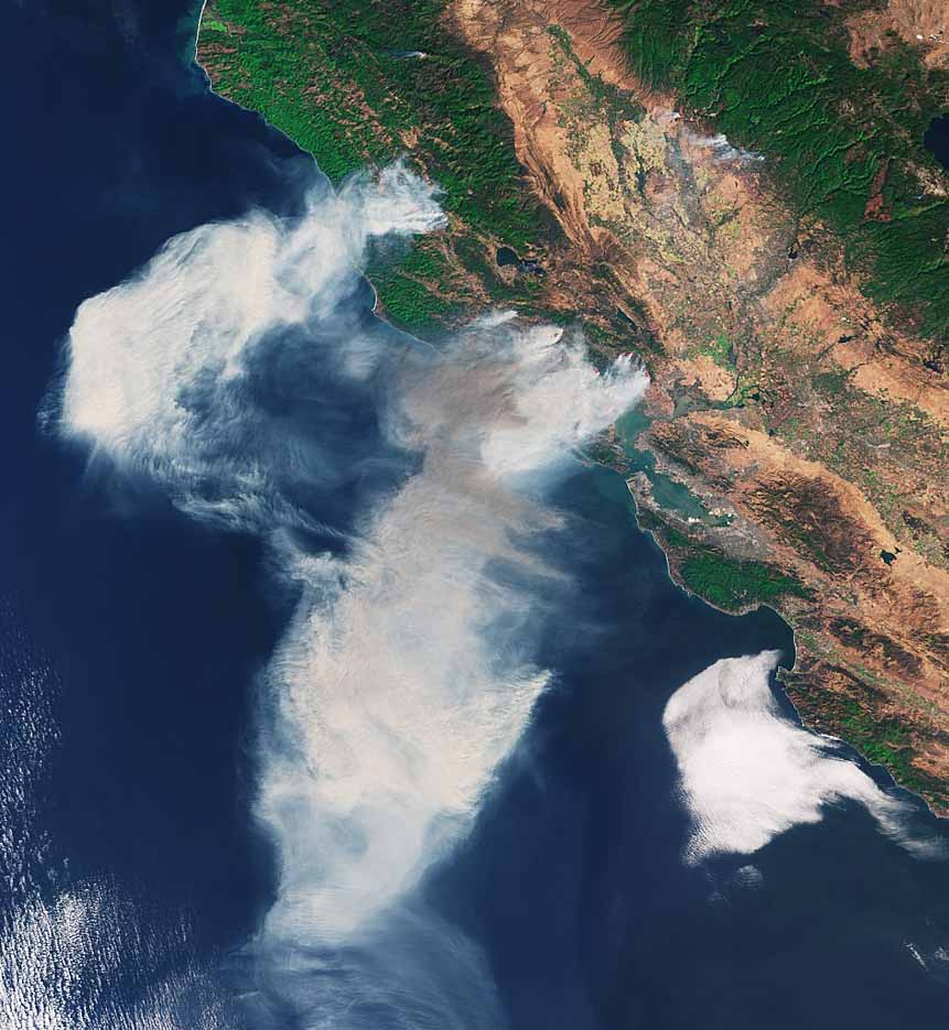
satellite photo northern California wildfires October 2017
Copernicus Sentinel-3A satellite picture of smoke from Northern California wildfires, October 9, 2017.

A year ago today more than 10 large very destructive wildfires were burning in Northern California. They started on October 8 and 9 pushed by very strong winds and eventually destroyed about 8,900 structures (including homes and outbuildings), burned at least 245,000 acres, and caused the deaths of 44 people.

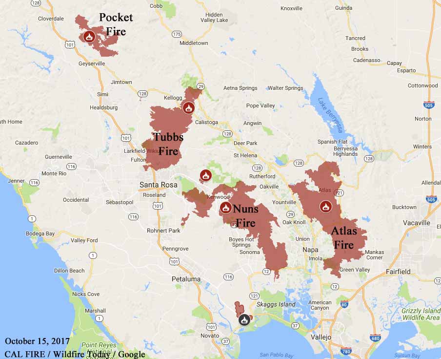
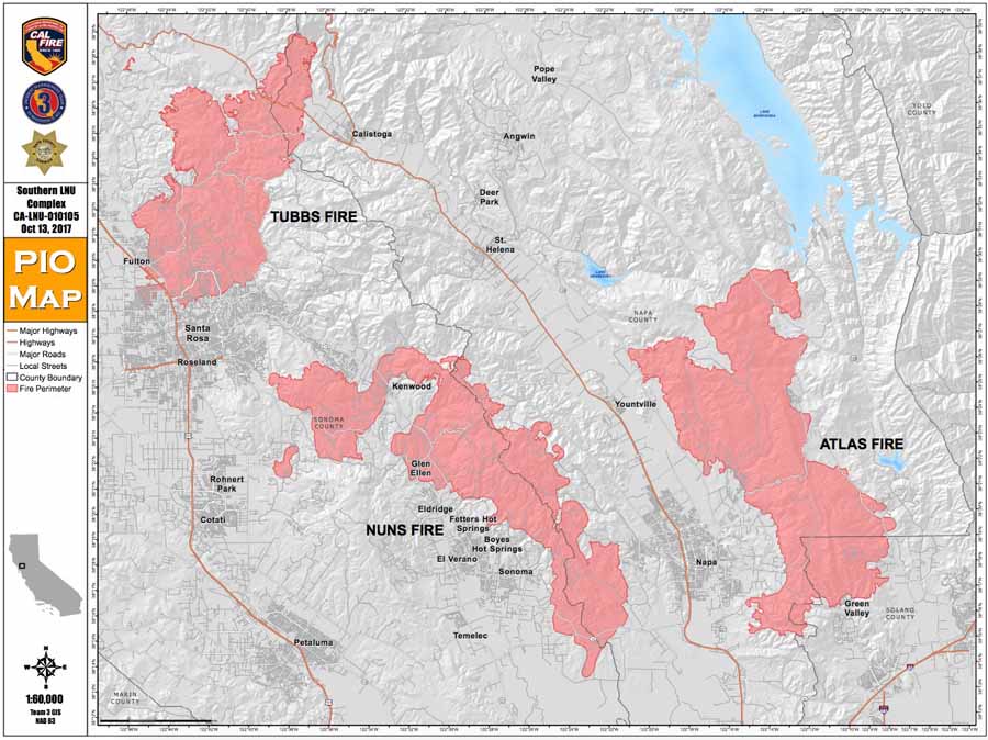
map Pocket, Tubbs, Nuns, and Atlas
Map showing the perimeters of the Pocket, Tubbs, Nuns, and Atlas Fires. CAL FIRE & Wildfire Today, October 15, 2017.

The fires instantly made thousands of residents homeless, and while rebuilding has begun, some are still struggling.

Many received no warning or alert on their telephones and were awakened during the night by neighbors pounding on their doors or the sirens of first responders.

list wildfires Northern California, October 2017.
The nine largest fires in Northern California, October 2017. Wikipedia. Click to enlarge.

Below are links to articles about the impact of the fires and the recovery.

Destructive Northern California wildfires have entered the record books

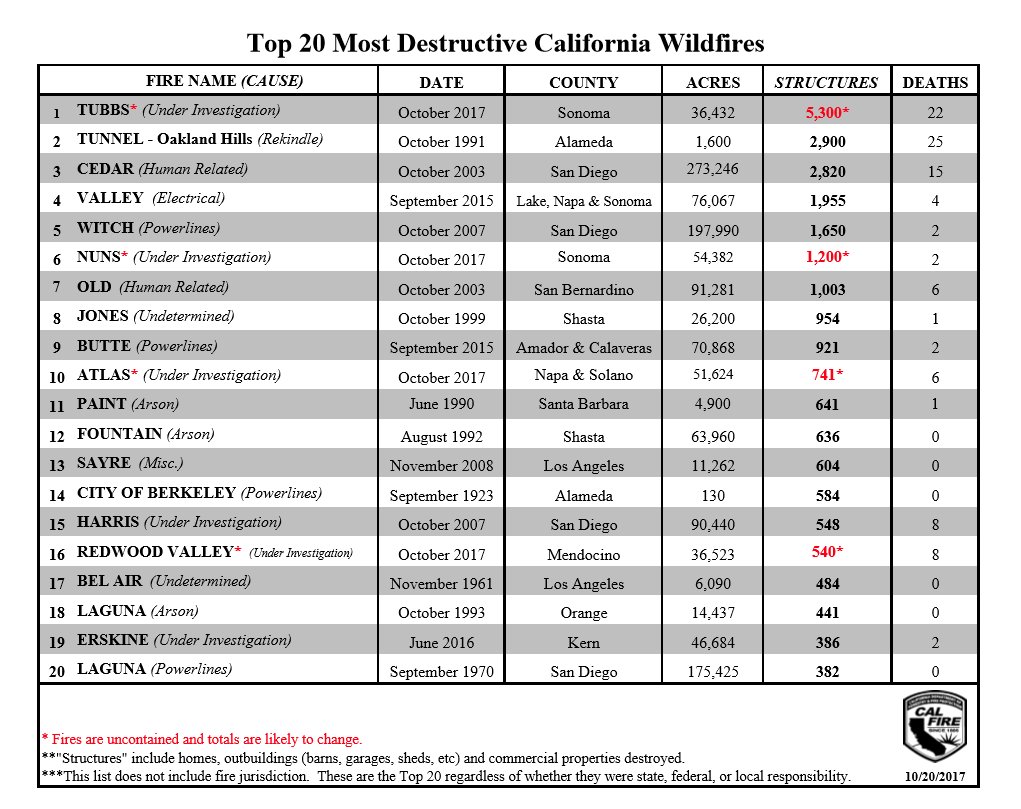
Four of the recent wildfires in Northern California are tentatively in the list of the top 20 fires in California, as ranked by structures destroyed. The exact numbers will probably change in the coming weeks as the post-fire surveys conclude.


destructive northern california wildfires records
“Structures” includes ALL structures — homes, commercial buildings, sheds, garages, and barns.

Northern California fires — hot and dry conditions Monday, but decreasing winds

At least 40 people have been confirmed dead in Northern California fires.

Above: Map showing the perimeters of the Pocket, Tubbs, Nuns, and Atlas Fires in northern California. CAL FIRE October 15, 2017.

(Published October 16, 2016)

Firefighters in Northern California are having some success on portions of the four largest wildfires near Geyserville, Santa Rosa, and Napa. However winds out of the southwest on Sunday caused the fires to spread on the northeast sides on all of the fires except the Atlas Fire which has been much quieter than the other three for the last two days.

Officials say 102,000 residents were either evacuated or had no homes to return to Saturday and Sunday in Sonoma County. Some evacuations were lifted late Sunday. Less than 2,000 stayed in evacuation centers.

firefighters map california

The fires in Sonoma and Napa counties have destroyed 3,947 structures. Approximately 4,230 personnel are fighting the blazes.

Officials report that 40 people have been confirmed dead in Northern California fires over the last week including fires in Mendocino County and near Yuba City.

  • Pocket Fire: 11,889 acres north of Geyserville. It continues to grow to the east and northeast.
  • Tubbs Fire, 44,481 acres. The most active area of the fire is still the northeastern portion around Red Hill and Mount Saint Helena. It continues to make short uphill runs on the north side of the peaks.
  • Nuns Fire, 48,627 acres. The northern portion 6 miles north of Calistoga grew to the north Sunday.
  • Atlas Fire, 51, 057 acres. It is much quieter than the other three fires.

McClellan Air Tanker Base
Air tankers at the McClellan Air Tanker Base. CAL FIRE photo.

The National Weather Service predicts hot and dry conditions for the Santa Rosa area Monday with a high of 88 degrees, relative humidity in the mid-teens, and west or southwest winds of 2 to 9 mph.

Tuesday should bring better conditions for firefighters; 81 degrees, 28 percent RH, and southwest winds at 3 to 11 mph.

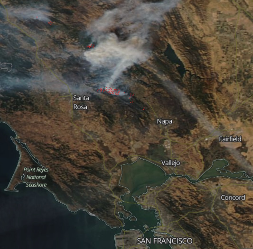
map photo satellite wildfires north of San Francisco
Satellite photo taken during the afternoon of October 15, 2017 showing smoke from wildfires north of San Francisco. The red dots represent heat.

Nuns Fire continues to spread while the Atlas Fire slows

More evacuations were ordered by Santa Rosa officials.

Above: The red lines on the map were the perimeters of the Nuns and Atlas Fires Friday in northern California at around 10 p.m. PDT. The white lines were the perimeters about 24 hours earlier. The yellow and red dots represent heat detected by a satellite on Friday night and Saturday, as late as 12:57 p.m. PDT.

(Originally published at 6:07 p.m. PDT October 14, 2017)

Additional evacuations were ordered Saturday in northern California by Santa Rosa officials for areas endangered by the 46,104-acre Nuns Fire. The new mandatory area is north and south of Hwy 12 between Calistoga Road and Adobe Canyon Road.

Evacuation orders are still in effect for many other areas. Santa Rosa has an interactive map showing which areas are affected.

Friday night and Saturday morning the most active areas on the Nuns Fire were on the northeast side of the huge fire. Overnight winds pushed the fire toward the Oakmont community in Santa Rosa and kept the fire spreading east of Sonoma.

On Friday the Nuns Fire grew by over 4,000 acres.

The Atlas Fire is east of the Nuns Fire, Highway 29, Yountville, and Napa. It was much less active than the Nuns Fire, growing by about 211 acres on Friday to bring the total up to 50,872 acres. Satellites detected much less heat than was seen on the Nuns Fire.

Northern California wildfires claim 31 lives and 137,000 acres

Above: map showing four of the larger wildfires north of San Francisco: Pocket Fire, Tubbs Fire, Nuns Fire, and Atlas Fire. They were mapped Thursday night between 9 p.m. and 11 p.m. PDT.

(Originally published at 11:28 a.m. PDT October 13, 2017)

Calmer winds and higher humidity on Thursday slowed wildfires burning north of San Francisco in Sonoma and Napa Counties, allowing firefighters to make progress toward containment, but each of the large blazes still added thousands of acres to their footprints.

Statewide in California there are 17 active wildfires that have burned a total of 221,754 acres. Approximately 8,000 firefighters are battling the blazes and thousands of residents have evacuated. At least 3,500 homes have been destroyed this week according to the California Department of Forestry and Fire Protection.

The death toll has risen to 31 and many people are unaccounted for.

Here is a closer look at the four largest fires in Sonoma and Napa Counties, working north to south. The sizes were updated by mapping flights Thursday night and total about 137,000 acres:

  • The Pocket Fire northeast of Geyserville and southeast of Cloverdale has grown to 9,996 acres. It was most active on the southeast side Thursday.
  • The 34,617-acre Tubbs Fire has burned at least 2,800 homes and many commercial buildings in Santa Rosa and Sonoma County. It did not expand much on Thursday, but was fairly active in some areas on the north and northeast sides. The fire is also burning in Napa County and is on both sides of Highways 128 and 101.
  • The Nuns Fire has merged with the Adobe and Norrbom Fires between Highways 116 and 121 — north, northwest, and east of Sonoma in both Napa and Sonoma Counties. The combined blaze now covers 44,381 acres. It was active on Friday northeast of the city of Sonoma and on the east flank in Napa County.
  • The Atlas Fire has burned 48,228 acres and is 17 miles long and about 6 miles wide. It is southeast, east, and north of Napa, primarily in Napa County.

The strong winds that have driven the fires decreased Friday, but Red Flag Warning conditions will return Friday night and Saturday with 20 to 30 mph northeast winds gusting at 40 to 50 mph. Isolated gusts up to 60 are possible on the highest ridges and peaks. The humidity will be in the teens during the day and between 25 and 35 percent at night.

The Red Flag Warning is in effect from 5 p.m. PDT Friday until 11 p.m. Saturday.

In the video below, Tanker 944, a 747, drops on the Pocket Fire.

Map Tubbs, Nuns Atlas Fires
Map of the Tubbs, Nuns, and Atlas Fires.