(UPDATED at 6:37 p.m. MDT June 16, 2020)
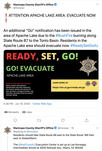
Tuesday afternoon the Maricopa County Sheriff’s Office issued an additional evacuation order, this time for an area on the south side of the Bush Fire — Apache Lake north of Highway 88:
More information about the evacuation can be found at the official Facebook page for the fire.

For all articles on Wildfire Today about the Bush Fire northeast of Phoenix including the most recent, click here.
(UPDATED at 2:26 p.m. MDT June 16, 2020)

Additional evacuations have been ordered for the Bush Fire.
From the Maricopa County Sheriff’s Office at about 1:30 p.m. MDT June 16, 2020:
ATTENTION: EVACUATE NOW
A “Go” notice has been issued in the area of Sunflower due to the Bush Wildfire burning along State Route 87. Residents in the Sunflower area should evacuate now. Grab your emergency Go-kit and go to your relocation area or with friends/family.
The Red Cross Evacuation Center has not been set up in Payson at this time. Drive with care and follow the directions of emergency personnel.
Just before the Sheriff’s Office issued the notice above, this was in another message about the new evacuation:
Evacuated residents should proceed north towards Payson. Proceed to the Payson Police Department at 303 N. Beeline Highway, Payson, AZ. 85541. Drive with care and follow the directions of emergency personnel.
More information about the evacuation can be found at the official Facebook page for the fire.
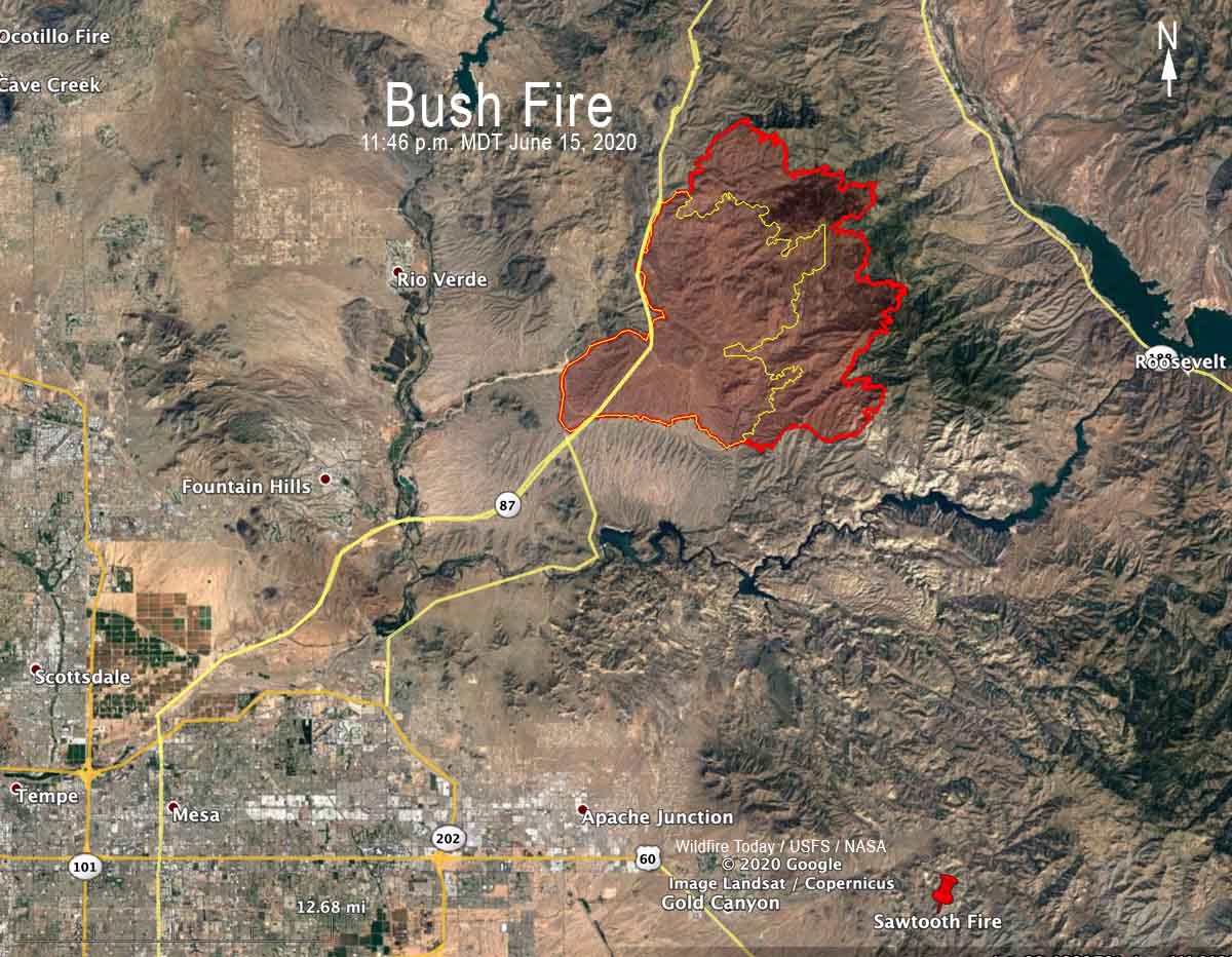
As of Monday night the Bush Fire had burned over 64,000 acres northeast of Phoenix, Arizona.
(Originally published at 8:07 MDT June 16, 2020)

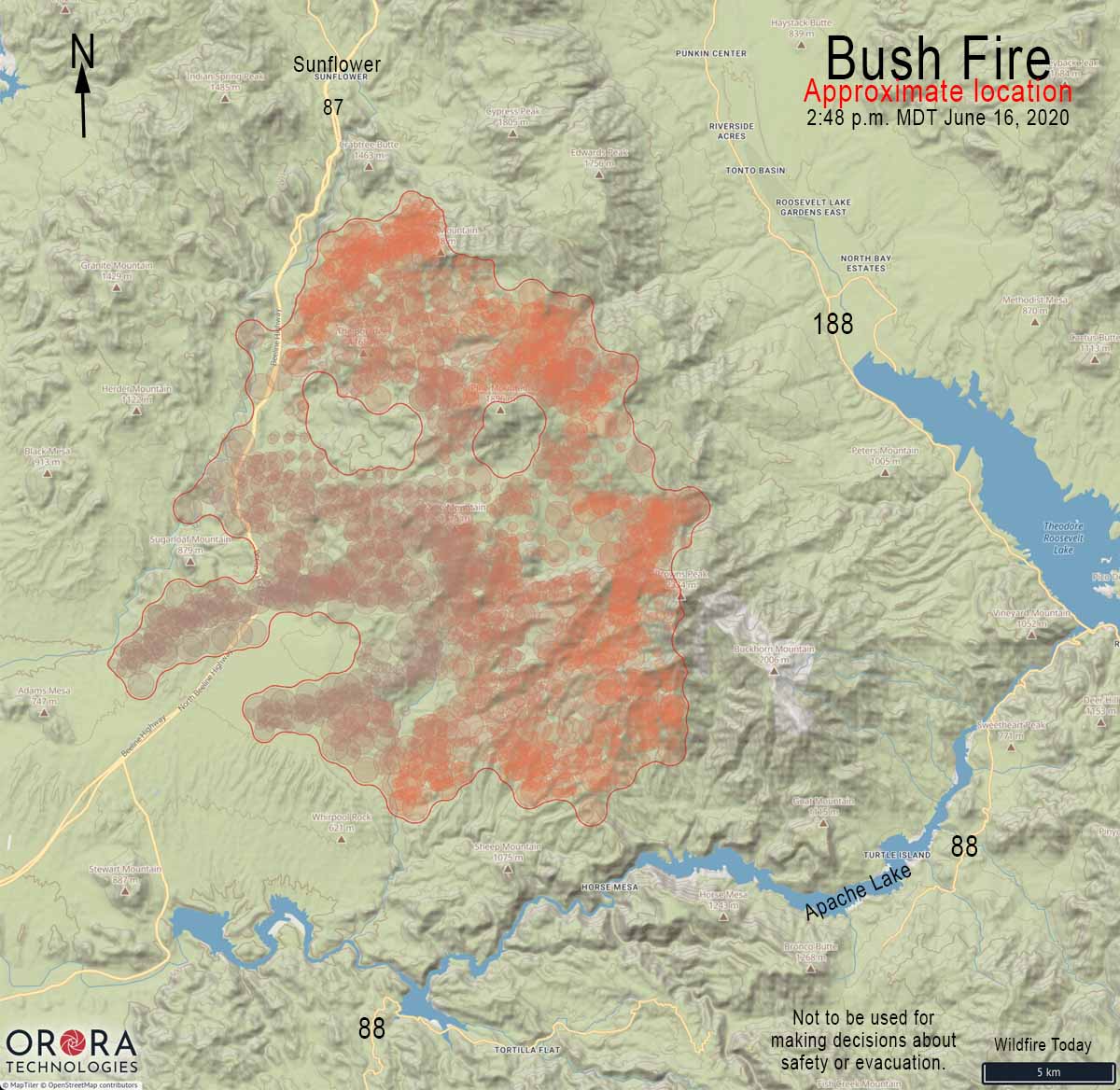
The “Bush Fire” northeast of Phoenix grew substantially Monday adding another 28,256 acres to bring the total to 64,513 acres. All of the growth was on the north and east sides, spreading away from the greater Phoenix area, but moving closer to the communities north of Theodore Roosevelt Lake, including Tonto Basin and Punkin Center.
For all articles on Wildfire Today about the Bush Fire northeast of Phoenix including the most recent, click here.
The fire is in the Tonto National Forest, with much of it within the Four Peaks Wilderness. The blaze has already burned over Boulder Mountain and Pine Mountain, and is close to reaching Brother Peak and Browns Peak, the highest point in the Wilderness at 7,659 feet.
On June 15 the Gila County Health and Emergency Department announced the evacuation of Tonto Basin and Punkin Center from Highway 188 and A-Cross Road to Highway 188 at Rambo Realty. The Sheriff’s office has more information about evacuations on their Facebook page.

A Type 2 Incident Management Team, Southwest Team 5, assumed command of the fire Monday morning.
The fire started June 13 at 2:00 p.m. near the intersection of Bush Highway and Highway 87. The cause listed on InciWeb is “human caused, vehicle fire”.
As of Monday, no structures have been damaged or destroyed.
Hot and dry weather is expected for the next several days with winds out of the Southwest. Tuesday may bring red flag conditions which will cause additional challenges for firefighters.

The Bush Fire has exceeded the size of the fire that for six years held the record for the largest fire in Arizona, the 61,000-acre Lone Fire, also in the Four Peaks Wilderness. It was caused April 27th, 1996 by a party of two campers who left a campfire unattended near Lone Pine Saddle. That record was blown away in 2002 by the 468,638-acre Rodeo-Chediski Fire at Show Low.


Please tell us what “Human-caused” activity set the fire in the first place?
We need this info to try and help it from being a “Human-caused” fire in the future.
Thank you
Vehicle fire on side of Beeline. Pretty vague description other than that. Very sad…….we love Four Peak soo much.
Hopefully the amethyst mine is ok for Mike. Fingers crossed……….
The Wallow fire in 2011 was the largest fire in Arizona history at over 500,000 acres. Fire was spotting over five miles. During the Rodeo-Chediski fire it spotted over two miles. Keeping trees and brush away from homes is vitally important, but proper forest management with a mix of timber harvesting, tree thinning, and brush control are key. However, this year with the wonderful winter and spring moisture the grasses have exploded, and then this dry weather has created the “perfect storm”. Our thoughts and prayers are with all.
What a tragic loss.
Obviously the concept of fire breaks as a tool for stopping fires is not accurate. This fire jumped back and forth across the roads. Fire jumped the Columbia River in Oregon! Early detection and control is a better approach based on unstoppable fire activity. Weather changes controls fire, not humans.
i work at the four peaks amethyst mine between the 3rd and 4th peak and left there monday the 15th anyway im concerned about our mine and cabin and if they are ok and if theres being anything done to protect them and dontnow who to talk to
Mark Blank,
Here’s a direct link to the Bush fire Inciweb page. You will find an information phone number here for the fire team managing the fire. https://inciweb.nwcg.gov/incident/6773/
Mike I was wondering the same thing about the mine, but can’t find any information. Did you ever find anything out?
Mike, my name is Tracy. I hope it is still in tact as wel… after all, im the one that built it there!