In the last ten years a great deal has been learned about the long-range dispersal of wildfire smoke. As Wildfire Today reported on August 9, 2010, smoke from fires in Russia last summer was tracked as it crossed the Pacific and entered the airspace above Canada.
A meteorologist told us at that time:
Based on the amount of smoke being produced by the Russian fires and at least this one occurrence [on August 3] of smoke being tracked across the eastern Pacific, I think it’s a reasonable assumption that some amount of smoke from Russia has made its way into North America.

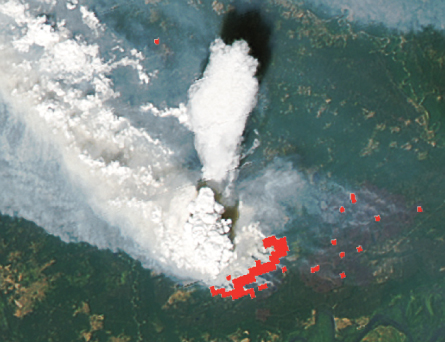
The photo above is astounding. Not only does it show the smoke plume rising many kilometers straight up into the atmosphere as if it were shot out of a cannon, but you can also see the result of moisture, a by-product of combustion, condensing and forming clouds downwind, far below the top of the tallest smoke plume.
The photo came from an excellent article by Sid Perkins which appeared on the Science News site, an excerpt of which is below. Oddly, the article is dated November 6, 2010, perhaps to match the date of a paper edition of their publication. (Remember when people used to read magazines printed on dead trees?)
=================================
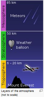
 …While it has been known for decades that large wildfires can create or enhance thunderstorm clouds, leading to what are called pyrocumulonimbus clouds, only recently have scientists discovered that the clouds can boost smoke into the stratosphere [20-50 kilometers above sea level]. Once in this layer of the atmosphere — immediately above the troposphere, where most of Earth’s weather happens — the smoke can be caught by jet stream winds and carried long distances, says Mike Fromm, a meteorologist at the Naval Research Laboratory in Washington, D.C.
Before the late 1990s, anomalous plumes of stratospheric aerosols were usually blamed on remote and therefore undetected volcanic eruptions, Fromm noted in August at the American Geophysical Union’s Meeting of the Americas in Iguaçú Falls, Brazil. But new analyses of satellite data, presented at the meeting and chronicled in the September Bulletin of the American Meteorological Society, reveal that pyrocumulonimbus clouds, or pyroCbs, regularly send smoke to the stratosphere. During the 2002 North American fire season alone, pyroCbs lofted aerosols to this layer more than a dozen times.
“In 2000, few scientists believed that these clouds could inject aerosols into the stratosphere,” says Pao Wang, an atmospheric scientist at the University of Wisconsin–Madison. “Now it’s almost taken for granted that they do.”
Along with aerosols, the high-flying plumes carry a heavy load of the chemically active gases that are produced in substantial quantities during a fire, especially in the smoldering phase. While their chemical and climatic effects aren’t fully known, the plumes’ dark particles tend to absorb sunlight, warming themselves and the atmosphere around them while cooling Earth’s surface slightly. A fuller understanding will help scientists fine-tune climate models, adjusting contributions of various aerosol sources.
In many ways, says Fromm, pyroCbs are just like other cumulonimbus clouds: They can provide prodigious amounts of precipitation and spawn a lot of lightning. Where pyroCbs differ from standard storm clouds, however, is in their source of convection. While it’s the heat produced by condensing water vapor that drives the updrafts in the towering thunderheads of cumulonimbus clouds, those in pyroCbs are largely driven by the intense heat of the wildfire at ground level.
That gives pyroCbs an extra push: The momentum from particularly strong updrafts enables the fire-fueled clouds to routinely make it to the lower reaches of the stratosphere. Even the tops of typical cumulonimbus clouds, in contrast, rarely rise out of the troposphere.
As a column of smoke rises from a wildfire, it pulls in surrounding humid air. The moisture in that air condenses to form the pyroCb cloud as the plume reaches high altitudes.
“Nobody really knows what happens inside these clouds,” Fromm says. But satellite images clearly show that smoke carried upward inside the clouds emerges from the top as if from a chimney, he notes.
(the rest of the article)
