Update: on June 21 we posted more information about the Monument fire, including a current map.
========================
Update: on June 16 we posted an updated article about the Monument fire.
=========================
Update at 7:33 MT, 6-15-2011:
Teresa Jun, a reporter for KOLD, said via Twitter about 20 minutes ago that she is at a public meeting and was told the fire has burned 9,300 acres. She said about 1,000 people were packed into the meeting room in Sierra Vista to hear about the fire. Strong winds are forecast for Thursday.
Added a time-lapse video.
Right now, a live streaming web cam is showing the fire.

=========================
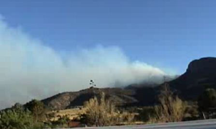
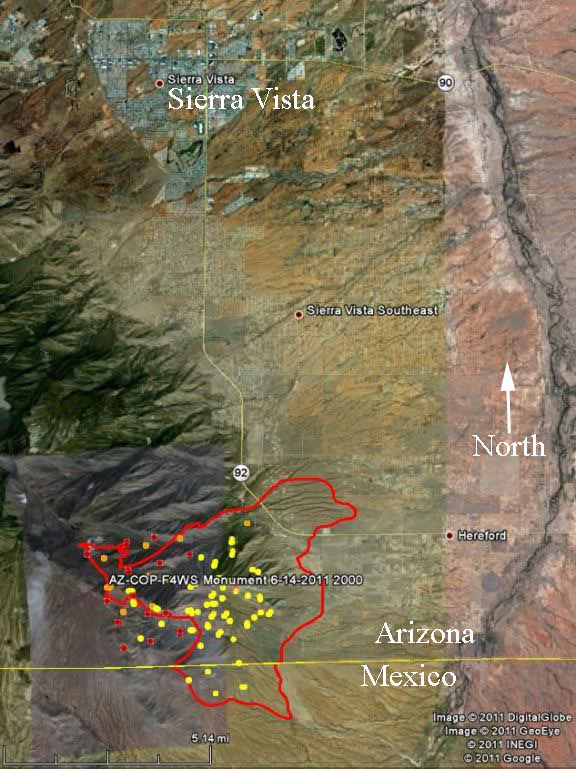
Still another fire in Arizona has developed into a serious, destructive incident. The Monument fire eight miles south of Sierra Vista started on June 12 and has blackened over 5,000 acres, burned or damaged 40 homes, and crossed the international border from Arizona into Mexico.
Scroll down to see maps of the Monument fire, but here is information from the Cochise County Sheriff’s Office, at 5:16 p.m., June 15:
Structure Damage/Loss:
50 structures (40 homes and 10 other structures) determined as of this time, damaged or lost in the Ash Canyon area including the listed roads: Ash Canyon Road, Muffin Lane, Deer Trail, Prince Placer, Acorn, Pickett Lane, Twin Oaks, Mountainview, Stoneridge, Turkey Track and East Spring Road. Additional assessments will be completed throughout the day.
Closures/Evacuations:
Ash Canyon, Hunter Canyon, Stump Canyon (both upper and lower), Turkey Track will remain closed until further notice.
Mandatory Evacuations:
West of Highway 92: Hereford Road to Ash Canyon Road. This includes East Flying V Lane East Miller Canyon Road, East Hillcrest Drive, East Bristlecone Lane, East Oak Haven, East Hunter Canyon, East Baumkirchner Road, East Stump Canyon Road, East Spring Road and South Deer Trail.
West of Highway 92: Hereford Road to S. Circle Drive and South to East Pioneer Lane to include Cave Place, Haul Drive, Davis Street, Shirley Drive, East Corral Drive, Madelein Drive, East Bricky Drive, East Roger Drive, East Linda Vista Drive, Olive Lane, Calle Coyote, East Antler Trail, La Paloma, Sunnyvale Road, Valley Vista and Pioneer Place.
People are encouraged to leave immediately.
Here is a link to a map that shows all of the large wildfires in the United States.
Maps and a time-lapse video of the Monument fire are below:
This time-lapse video becomes pretty impressive about two-thirds of the way in.


There is a problem with wildfires on the US/MX border. It’s a firefighter and community safety problem and SHOULD never dissolve into a political issue.
US Forest Service Border Fire Prevention: Vid 1 http://bit.ly/jAlm7x & Vid 2 http://bit.ly/ltwGQ3
Dever: “When this fire started, Montezuma National Monument was closed. The forest around it was closed….So, whoever started the fire was there illegally.”
Video removed.
Dever: the fire started right near the U.S.-Mexican border fence, and the only ones “traveling through that area at that time were smugglers or illegal aliens”.
So who do you believe, America? A lawman of 35 years? Or La Raza, who said McCain was “immigrant and Latino bashing”? And when did McCain or anyone ever mention “immigrants” (illegal aliens are INVADERS, not immigrants), or “Latinos” (thousands of captured border crossers every year are from nations like China, India, Paksitan and Indonesia).
Azbluejacket-
It took me quite a while to figure out what you were talking about. I believe by “Dever” you are referring to Sheriff John Dever, of Cochise County Arizona. At KVOA.com he was quoted as saying: “”When this fire started, Montezuma National Monument was closed. The forest around it was closed. So, whoever started the fire was there illegally.”
Sheriff Dever may be referring to Montezuma Castle National Monument, which is in central Arizona near Camp Verde, about 300 miles away from the Monument fire. (map). If he was talking about the origin of the Monument fire south of Sierra Vista near the Arizona/Mexico border, then he was very confused.
There is another National Park Service site near where the Monument fire started, and that is Coronado National Memorial.
I don’t know what started the fire. Maybe Sheriff John Dever has a better command of the facts regarding the cause and origin of the Monument fire than he does of geography.
Has the fire gone into Huachuca Oaks campground?
Jerry, I’am a retired fire captain
I worked for the calif dept of forestry for 29 years. My fire station was located 30 miles east of san diego just 4 miles from the mexico border and in 1995 we had 350 fires started by border crossers basicly the same kind of terrain with only one mountain in and out. My wife and I own property in Wildhorse and in kings ranch and we are getting the fire info from a friend in sierra vista the firemen will do a good job
you know i live in sierra vista, and this fire as taken the best of us this year, but what i cant figure out is why/ how was this fire started? it has gotten to the point to where no one can get to it but the plans for water. What are we suppose to do if it gets to bad or even a lot worse? What are we suppose to do if it gets closer to in town?
Nothing has been done to maintain permanant fire breaks to prevent the spread of fires such as this. Every couple of miles there should be cleared areas with catch fences wide enough that no wildfire could cross with minimal effort from firefighters.