Update: a new article about the Las Conchas fire was written on June 30, 2011.
============================
Update at 7:36 p.m. MT, June 29, 2011:
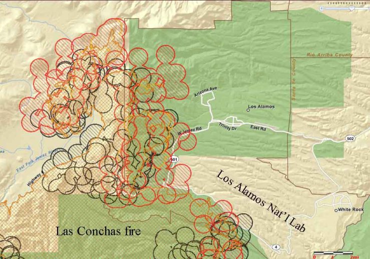
Below, is a a new map showing heat detected by satellites at 2:50 p.m. MT, June 29, 2011. This map zooms in on the north side of the fire near the city of Los Alamos, an area that showed some growth on Wednesday, either from a burning out operation by firefighters or natural movement of the fire, or both.

The incident management team today finally posted two maps of the fire on their InciWeb site:
- Current as of 10:30 p.m. June 27, 2011
- Created 3:31 p.m. June 28, 2011
============================
Update at 3:10 p.m. MT, June 29, 2011:
(more maps and information are below)

The map above show some significant expansion of the Las Conchas fire since Tuesday night at 11:43 p.m. But don’t get too excited by the map — the symbols are placed in the approximate location of the heat and should not be interpreted as the exact location of the fire.
The north side has advanced approximately 2 miles, and the satellites detected heat closer to the 501 road and the Los Alamos National Laboratory. The heat near the 501 may be the result of controlled burnouts conducted by firefighters, as described at New Mexico Fire Information in an article dated at 10:45 a.m on Wednesday. Here is an excerpt:
LOS ALAMOS, New Mexico June 29, 2011 – Fire crews on Wednesday morning will begin a series of targeted, preventative burns along the western edge of Los Alamos National Laboratory in an effort to further remove available fuels from the Las Conchas Fire. Observers may notice increased smoke coming from the LANL border. At this time there is no wildfire on Laboratory property.
A live camera on the National Lab property has a good view of the smoke from the fire on Wednesday afternoon.
Here’s another cam at “Los Alamos County”.
===============================
Update at 12:23 p.m. MT, June 29, 2011:

The Incident Management Team has provided some updated information about the Las Conchas fire:
- 69,555 acres burned, based on Tuesday night’s infrared mapping flight. this is an increase of about 9,000 acres over the last 24 hours.
- Equipment and aircraft: 4 dozers, 12 engines, and 5 helicopters (these seem like incredibly low numbers for a fire of this size and complexity)
- Containment: 3%
- Residences destroyed: 12
- Evacuations: the city of Los Alamos is evacuated; White Rock is under a voluntary evacuation (more info)
=============================
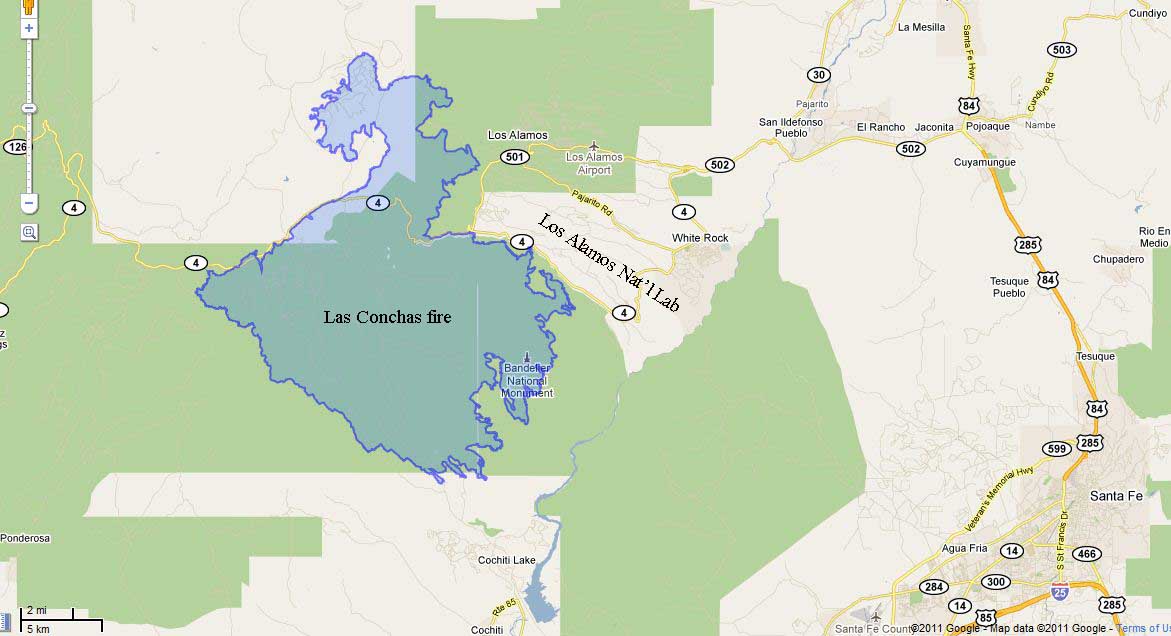
Update at 9:56 a.m. MT, June 29, 2011: replaced the map with a much better version.

=================================
The Las Conchas fire continued to spread Tuesday and Tuesday night, moving about two miles on the north side and about one-half mile on the southwest side. The east flank is now less than one-half mile from the 501 road west of Los Alamos after spreading about one mile over the last 24 hours.
Los Alamos is still under evacuation orders. More information about evacuations is at InciWeb.
Other than the one-acre spot fire a couple of days ago, firefighters have been able to keep the fire out of the Los Alamos National Laboratory, where Forbes reports that 30,000 55-gallon drums of plutonium-contaminated waste are stored, some of them in tent-like structures. Doug Tucker, the Chief of the Los Alamos Fire Department, said yesterday that the barrels are surrounded by bare mineral soil or asphalt and there little chance that the fire could impinge on the barrels. The operations manager of the Lab said that if a wildfire does approach the radioactive materials they have equipment on site that will cover them with foam, further protecting the barrels from fire.
The last acreage reported by the incident management team on InciWeb on Tuesday was 60,741, but the fire has probably added another 5,000-10,000 acres over the last 24 hours.
There are now two Type 1 Incident Management Teams and one Area Command Team managing the fire. It will will be divided into zone,s with Joe Rienarz’s Team managing the north zone and Dugger Hughes’s Team managing the south zone. Dan Oltrogge’s Area Command Team will allocate resources, set priorities, and supervise both Type 1 Teams.
We will update this article on Wednesday as new information develops.


Great coverage, very timely. Thank you.
SP
Thank YOU, Steve. 🙂
Thanks for the continued good maps, photos and information on the fire(s).
I’m sure that resources are in demand plus with a fire moving that fast IC’s are not going to put people in the way. With fires of that size and intensity nothing much is going to happen till the weather changes or it runs out of fuel. Long distance multiple spotting into ready to burn fuels creates a very complex and fluid situation.
“Equipment and aircraft: 4 dozers, 12 engines, and 5 helicopters (these seem like incredibly low numbers for a fire of this size and complexity)”-
just what I was thinking- and also, considering the values at risk?! like, a gazillion tons of radioactive material?!! I’ve been on much smaller fires with much less at risk with the same number or more people- what gives here? Budget cuts?
Surprisingly enough, it is incredibly hard to get up-to-the- minute information on a fire even if you happen to be working for an IMT sometimes.
WHERE IS THE FIRE BURNING NOW? There is a huge cloud/smoke plume visible from Santa Fe at 1:00 p.m. Is the fire burning on LANL property? It is very difficult to get up-to-the-minute information about exact location and risk to the public from fire at the Labs.
Thank you for your hard work and dedication in posting info.