UPDATE at 2:53 p.m. MT, July 20, 2011:
A few updated facts about the WhoopUp fire from a spokesperson for the fire:
- A recent GPS mapping flight revealed that the fire has burned 7,343 acres.
- Today there are two or three heavy air tankers available and one more on order. (The number varies depending which official source you talk to.)
- Four large Type 1 helicopters are assigned to the fire. These typically come with significant entourages and large fuel and maintenance trucks. They are working out of the Newcastle Airport. It’s quite a coup to get four of these large helicopters on a 7,000-acre fire. They can be VERY effective if a water source is nearby, with each dropping many thousands of gallons of water every hour. One smaller Type 3 helicopter is on the fire, primarily being used for mapping, observation, and intelligence gathering.
- The Barrel fire five miles south of the WhoopUp fire began as two separate fires that, according to a spokesperson for the fire, grew together. The suppression of that fire is being handled by the WhoopUp fire organization.
===================
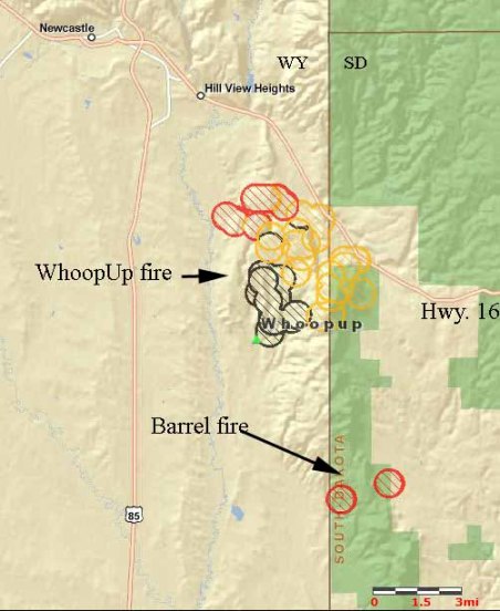
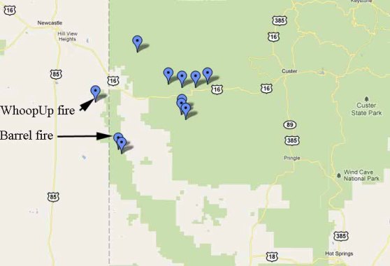
UPDATE at 9:50 a.m. MT July 20, 2011: updated the map and included more details about the WhoopUp and the Barrel fires, and added a new map showing nine other fires in the area.
====================
8:45 a.m. MT, July 20, 2011:
We will update this article throughout the day.
Here is a map of the WhoopUp fire showing heat detected by satellites at at 3:59 a.m. MT July 20, 2011. The red areas depict active burning, while the yellow and black areas indicates heat detected within the last 12 or 24 hours respectively.

The heat sources in South Dakota about five miles south of the WhoopUp fire are from a new fire, the Barrel fire. It is being managed by the same team suppressing the WhoopUp fire.
A spokesperson for the fire, Hollie Belmedico, told us that firefighters made good progress on the 5,544-acre fire Tuesday night and now they are able to call it 40% contained. There are at least 250 firefighters and six dozers assigned, along with a mix of Type 1 and Type 3 helicopters. Ms. Belmedico did not know how many helicopters or air tankers will be available today or the size of the new Barrel fire.
The weather forecast for the area of the fire has changed a little. Yesterday the Weather Service said the relative humidity would bottom out at 31%, but today they are forecasting a minimum RH of 25%, a high temperature of 83, winds out of the northwest (then north and later northeast) at 11-23 gusting up to 31, a 31% cloud cover, and 0-10% chance of precipitation. The predicted winds and the lower humidity could cause the fire to spread to the southeast, and later in the afternoon and evening to the south and eventually the southwest — unless the firefighters have strong firelines in place on the south side of the fire.
The map below shows fires or reports of fires that firefighters have responded to in the Newcastle and Custer area since July 18. Most of them were suppressed at less than 3 acres.
Help us out by telling Google you like this article by clicking the Google +1 button below. Thanks!


Just found today’s update – thank you!
Hi Meg. Ask, and ye shall receive…. sometimes even BEFORE you ask. 😉