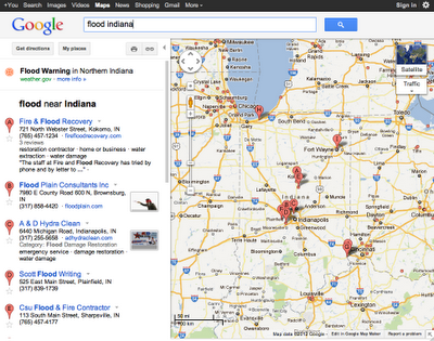
Google has launched a service that displays emergency alerts on a map. According to Google, if you go to Google Maps and search, for example, for “Flood Indiana”, it will display icons at locations that have flood warnings or advisories. Or, you can go directly to the Google Public Alerts page and see the alerts that have been posted. Zooming in sometimes causes more alerts to be displayed.
Google’s announcement about the service that was posted on January 25 does not mention if wildfires or evacuations would be part of this system, but they do say that “public safety” will be one of their objectives.
Here is an excerpt from Google’s announcement:
==========================================================
“…The Google Crisis Response team works on providing critical emergency information during crises. Our goal is to surface emergency information through the online tools you use everyday, when that information is relevant and useful.
With today’s launch of Public Alerts on Google Maps, relevant weather, public safety, and earthquake alerts from US National Oceanic and Atmospheric Administration (NOAA), the National Weather Service, and the US Geological Survey (USGS) will be accessible when you search on Google Maps. For instance, at the time of this post, “Flood Indiana” triggers an alert for a Flood Warning in Northern Indiana.
 If you click through to “more info” on this alert, you’ll find a page showing more details about the alert, with the full description from the alert publisher, in this case the National Weather Service, a link to their site and other useful information.
Whether you see an alert depends on which alerts are active at a given location, their severity, and your search query. If you’re interested in seeing all of the active alerts in one place, visit our homepage at www.google.org/publicalerts. This page also provides a link to more information on our new platform and gives instructions to interested organizations who want to make their emergency data available through this tool.”

