(UPDATE at 7:15 p.m. PDT, July 28, 2014)
Firefighters continue to make progress on the Sand fire south of Placerville, California. The Incident Management Team still maps the fire at 3,800 acres but the containment has increased from 65 to 75 percent. These percentages are generally very arbitrary and meaningless. They are sometimes pulled out of the air (or other places), depending on the political climate, the evacuation situation, and the phase of the moon. Back in the old days it was actually the percentage of fireline that had been constructed vs. the total perimeter of the fire, as described in the National Wildfire Coordinating Group’s glossary of firefighting terms.
There has been a decrease in the areas under evacuation orders and the number of firefighting resources assigned, as well.
****
(UPDATE at 6:23 p.m. PDT, July 28, 2014)

According to CAL FIRE the Sand Fire south of Placerville, California has not grown over the last 24 hours, with the size Monday morning remaining the same as on Sunday — 3,800 acres — while the containment has increased to 65 percent.
The number of structures burned has increased to 13 residences and 38 outbuildings. The resources assigned to the fire include 1,937 personnel, 196 engines, 51 hand crews, 30 dozers, and 52 water tenders.
California wildfires destroy 10 homes, 100s of people evacuated #SandFire #ElPortal http://t.co/y561pXHv6O pic.twitter.com/WFvGtW7T9l
— BBC News (World) (@BBCWorld) July 27, 2014
****
(UPDATE at 8 a.m. PDT, July 27, 2014)
CAL FIRE is releasing very little detailed information about the Sand Fire near Placerville, California, but a few minutes ago they announced that the revised size of the fire is 3,800 acres (down from 4,000) and said it is 35 percent contained. The fire has burned 10 residences and 7 outbuildings. The Sacramento Bee reported that Chris Anthony, A CAL FIRE spokesperson, said the fire was caused by a vehicle driving over dry vegetation. We will post an updated map of the fire when it becomes available.
****
(UPDATE at 9:30 p.m. PDT, July 26, 2014)
CAL FIRE reported at 8:15 p.m. that the Sand Fire south of Placerville, California has grown to 4,000 acres with 20 percent containment. There is no change in the number of structures burned; five residences and seven outbuildings. Resources working on the fire include 1,464 personnel, 149 engines, 45 hand crews, and 16 dozers.
#SandFire around 3pm from @HelwigWinery pic.twitter.com/PTmqq938vr — James Thorall (@JimThorall) July 27, 2014
****
(UPDATE at 7:43 p.m. PDT, July 26, 2014)
At 4:34 p.m. PDT CAL FIRE estimated the size of the Sand Fire south of Placerville at 3,000 acres with 20 percent containment.
****
(UPDATED at 4:25 p.m. PDT, July 26, 2014)

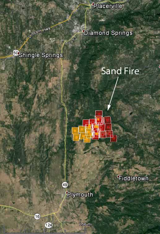
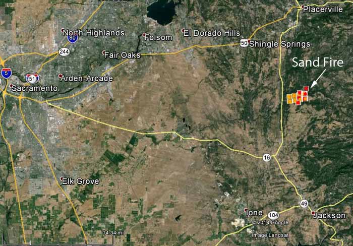
The red icons on the map of the Sand Fire above represent heat detected by a satellite at 2:14 p.m. PDT, July 26, 2015. It shows significant growth on the east side, compared to the map below from about nine hours earlier. The yellow icons represent heat from Friday. The fire is putting up a large column of smoke visible from Sacramento. Air Attack has requested more air tankers of any type; with the numerous structures that are threatened and the ongoing evacuations, he is not particular at this time which type shows up. Firefighters are burning around some of the structures ahead of the fire to reduce the fuel available when the fire reaches them. **** (Originally published at 2:29 p.m. PDT, July 26, 2014)

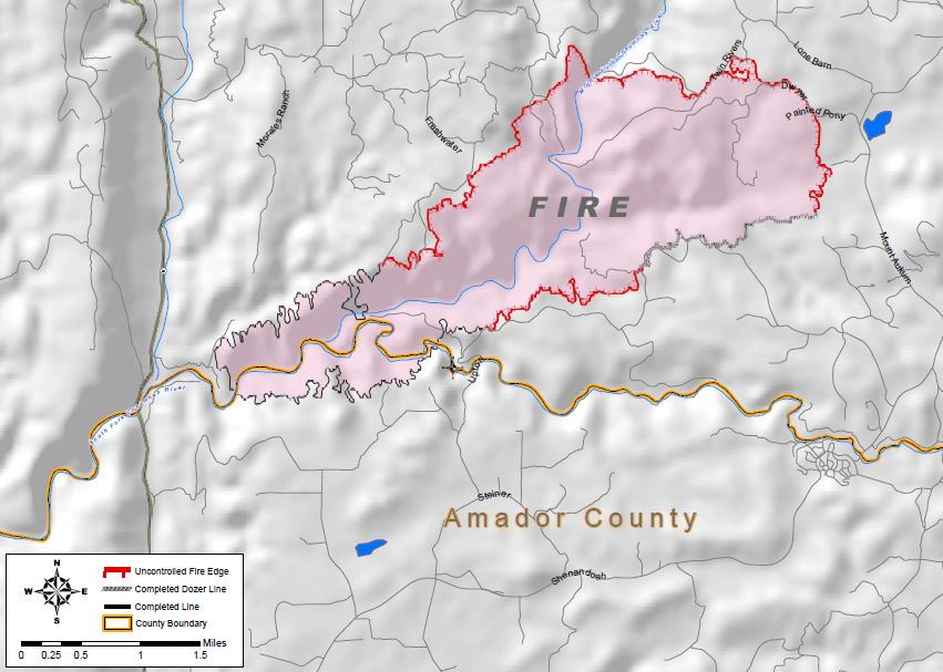
The Sand Fire, 10 miles south of Placerville, California, required the evacuation of several dozen homes a few hours after it started at 4:30 Friday afternoon. The spread of the fire slowed down by sunset under an aggressive aerial assault, but picked up again during the night. As this is written at 2 p.m. PDT, spot fires are helping the fire spread toward structures. Air Attack has ordered a total of seven air tankers, including one of the DC-10 Very Large Air Tankers. Five strike teams of engines, with five engines each, were ordered earlier. The fire is 14 miles north of Jackson and 33 miles east of Sacramento. (See the map of the Sand Fire above.) At least 13 structures have burned, including 4 residences. CAL FIRE reported at 8 a.m. on Saturday that the fire had blackened 1,300 acres and they were calling it 20 percent contained. It is being fought by 672 personnel, 53 engines, 21 hand crews, and 9 dozers. The weather on Saturday is making it difficult for firefighters, with a prediction of 98 to 103 degrees, a relative humidity of 8 to 13 percent, and winds gusting up to 18 mph out of the west in the afternoon.
#sandfire View from Story winery. pic.twitter.com/etTb2Vi1e2 — Kevin Oliver (@KCRAKevin) July 26, 2014

Will I b able to drive to Tahoe tomorrow AM on hi way 50?????
From the El Dorado National Forest today, July 24:
How are the China Flat and surrounding campgrounds affected?
yubanet.com has a perimeter map posted.
http://yubanet.com/CAFires/SandCA.php
Sensational T.V. news. What is occurring on the Sand Fire (T.V.) isn’t what is occurring on the Sand Fire. Hard aggressive work, a little break from Mother Nature and the tide has changed. As mentioned Cal Fire updates (530) 647-5218.
Are you on this fire? I would like to see map overlays.. hard to come by as well as information…
who is the CIO on this fire?
None of us can find any info, it’s like we are blacked out..
Can I go home now.
Yubanet is more current than anything.. good service.
~Frustrated~
Is the fire near the intersection of Sandridge and Elderberry Road?
Great web page with so much info. May I ask if perry creek off FairPlay is in any danger?
Perry Creek is in the “voluntary evac” area. Those of us who live here are not sure if we have an all clear at this time. Many of us are going to attempt to go home tomorrow.. to see. that is .. Monday.
I am in Florida, My dad is Nutmeg Lane the other end of Sandridge does it seem to be heading that direction? Is there any live feed I can get up to date information to him?
Well, those of us who live here wish we could get any feed. We are relying more on each other and line of sight. Nutmeg is at the Bucks Bar end… A lot of people bugged out .. Mandatory evac. some stayed. the world most awesome fireguys are holding the line and working to keep it back.. Nutmeg is in the line, but at this time the fire has not reached that area. map of fire area as of today. http://yubanet.com/CAFires/SandCA.php
Is this fire moving towards Fiddletown?
no not at all.. more north east toward.. fairplay area.
If the fire gets across E 16 today from the Outingdale area, look out! Mother Nature again showing who is boss. Cal Fire and cooperating agencies have been doing a fantastic job of “flanking” the fire but the front (head) is producing lots of energy.
Is Grizzly Flat in the path of this fire??
No.. not at all. or not at this time. ( does not seem likely)
Is little canyon rd or church mine rd in danger only one way in or out? My email is lv2trvl2013@gmail.com
I don’t like what I’m seeing this morning, atmospheric instability. Another wild and dangerous fire day ahead. One way in one way out? Don’t wait for the Sheriff to tell you to leave, use your own judgment. (530) 647-5218 CalFire info.
I did the CWPP for this area you can see from the map resistance to control was high to extreme
Please keep me updated. I am at the top of ridge on Wish Upon Way last home. 10 acre wooded homes above clear creek. Near corner of pleasant valley Rd and Newtown Rd an holiday market. Only one way out thru shooting star Rd and Starkes grade.
Just returned from the fire. Moving toward E 16 into Mt. Aukum, toward Outingdale. Don’t let the smoke ‘laying” over you location spook you. Stark and Newtown are not in any threat from this fire.
Fire info CalFire (530) 647-5218.
Just because you love air tankers.
http://www.sacbee.com/2014/07/25/6583668/photo-gallery-07-25-213808.html