(UPDATE at 10:49 a.m. PDT, September 27, 2014)
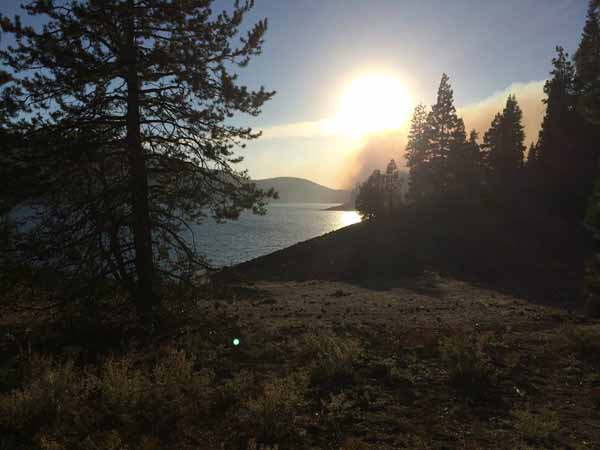
The King Fire east of Placerville, California was slowed by rain on September 25, but the incident management team is still showing a modest increase in the size — now at 97,099 acres, an increase of 1,752 over the last two days.
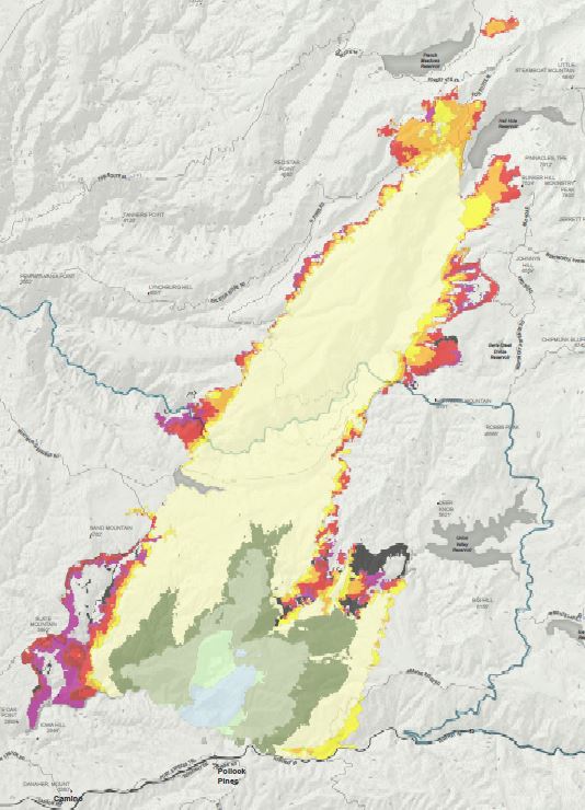
The numbers:
- Current Acreage Burned: 97,099
- Percent Containment (according to the Incident Management Team): 78%
- Structures Damaged or Destroyed: 80 (12 residences, 68 others)
- Injuries: 6
- Structures Threatened: 289
- Cause: Arson
- People Evacuated: none
- Total Personnel Assigned: 6,497
- Other resources assigned: 172 hand crews, 418 engines, 21 helicopters
- Fire suppression costs to date: $77,000,000
Current Situation Zone 1 (north portion): Fire crews continue to patrol, mop up, hold, and improve existing control lines throughout Zone 1. Rain showers and isolated thunderstorms Friday night have assisted in the efforts of further containment and are forecasted to continue throughout the day on Saturday. The demobilization process continues.
Current Situation Zone 2 (south portion): Temperatures will continue to be cool with the chance of showers and thunderstorms expected throughout the day on Saturday. Crews continue to mop up, hold, and improve existing control lines. Fire Suppression Repair Teams are preparing to work in the areas affected by the fire. The demobilization process continues to release excess resources while maintaining an adequate amount to meet the needs of the incident. In an effort to prevent the spread of non-native weeds and diseases within the forest, a vehicle rinse station has been established using water conservation measures and run off containment.
****
(UPDATE at 4 p.m. PDT, September 25, 2014)
Most of the rain has now passed through the King Fire Area. Here are some precipitation totals for today at nearby weather stations:
- Duncan: 0.83″
- Bald Mountain: 0.79″
- Seed Orchard: 0.95″
This rain will not put out the King Fire, but it will virtually eliminate the threat of rapid fire spread for a few days. The Incident Management Team will no doubt put to work the 182 hand crews to complete the line around the fire, getting much closer to 100 percent containment. There could be a massive demobilization of some of the 8,002 personnel on the fire over the next two or three days.
****
(UPDATE at 1:22 p.m. PDT, September 25, 2014)
As we write this, rain is falling over the King Fire. A flash flood warning has been issued for the area until 6:15 p.m. The Bald Mountain weather station four miles west of the fire measured 0.55 inch of precipitation Thursday, through 12:36 PDT.
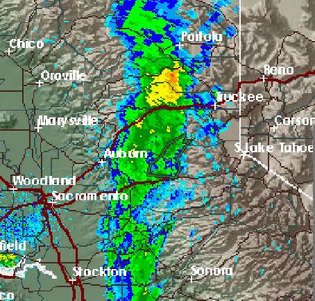

The perimeter of the fire has not changed much over the last several days. There are areas on the east and west flanks where the fire has spread a relatively small amount, indicating that there is still quite a bit of fireline that still has to be built, but the recent weather, and especially the rain today, are making that task much easier that it would be if hot, dry, windy weather was affecting the fire.
The numbers:
- Current Acreage Burned: 95,347
- Percent Containment (according to the Incident Management Team): 43%
- Structures Damaged or Destroyed: 69 (12 residences, 57 others)
- Injuries: 6
- Structures Threatened: 21,000 (12,000 residences)
- Cause: Arson
- People Evacuated: 2,830
- Total Personnel Assigned: 8,002
- Other resources assigned: 182 hand crews, 558 engines, 22 helicopters
- Fire suppression costs to date: $62,000,000
****
(UPDATE at 3:22 p.m. PDT, September 24, 2014)
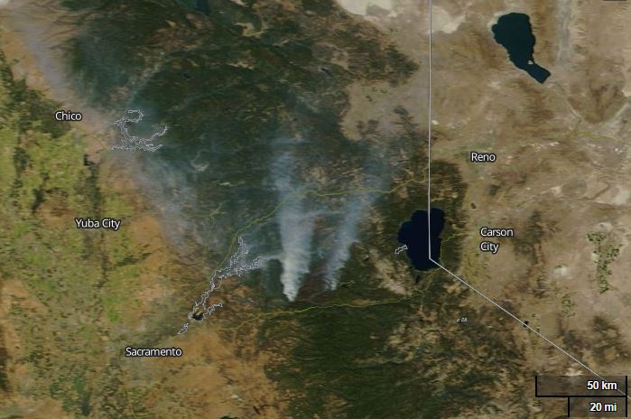
NASA satellite photo of the King Fire, September 24, 2014.
****
(UPDATE at 8:46 a.m. PDT, September 24, 2014)
There have been no major changes in the spread of the King Fire between Pollock Pines and Lake Tahoe over the last 24 hours. Firefighters tied in much of the large firing operation on the southwest side in the Pino Grande, Fairbanks, Deer View, and Slab Creek Reservoir areas. When all of the firing is complete on the entire fire, that additional acreage alone will probably push the total size over the megafire threshold of 100,000 acres.
- Current Acreage Burned: 92,960
- Percent Containment (according to the Incident Management Team): 38%
- Structures Damaged or Destroyed: 12 residences and 57 other type structures were destroyed in the south portion of the fire.
- Injuries: 4
- Structures Threatened: 21,000 (12,000 residences)
- Cause: Arson
- People Evacuated: 2,830
- Total Personnel Assigned: 7,621
- Other resources assigned: 170 hand crews, 547 engines, 21 helicopters
- Fire suppression costs to date: $52,000,000
Current Situation Zone 1 (northern portion): Firefighters were very successful in strengthening control lines last night along the Chipmunk ridge and throughout the northern portion of the fire. Red Flag warnings will continue throughout the day, which may increase fire behavior along with the potential of spotting. Humidity levels will continue to drop as increased southeast wind gusts in the mid-teens are expected. A Fire information call center in the Truckee Tahoe Basin has been established to assist citizens in Placer County with questions pertaining to the King Fire. The number is (530) 587-9096 Community meetings that were scheduled last night were well attended with fire officials addressing public concerns on the King Fire.
Current Situation Zone 2 (southern portion): Red Flag Warnings are predicted over the fire area for high winds and low relative humidity through tonight at 8:00 p.m. With the southwest wind there is the potential for extreme fire behavior if the winds, fuels and topography come into alignment. The fire remained relatively active throughout the night due to the poor relative humidity recovery.
The King Fire is being managed in Unified Command with Eldorado National Forest, El Dorado County Sheriff’s Office and CAL FIRE. The Federal Team CIIMT 5 (Jim Giachino) will be coordinating firefighting operations of Zone 1 (northern portion) of the fire, and CAL FIRE IMT 5 (Kevin Smith) is managing Zone 2 (southern portion) of the fire.
****
(UPDATE at 6:17 p.m. PDT, September 23, 2014)
These are the updated official numbers for the damage assessment in the White Meadows area:
-
-
- 12 Residences 100% destroyed.
- 1 Residence damaged.
- 57 Outbuildings 100% destroyed.
- 0 outbuildings damaged.
-
****
(UPDATE at 12:43 p.m. PDT, September 23, 2014)
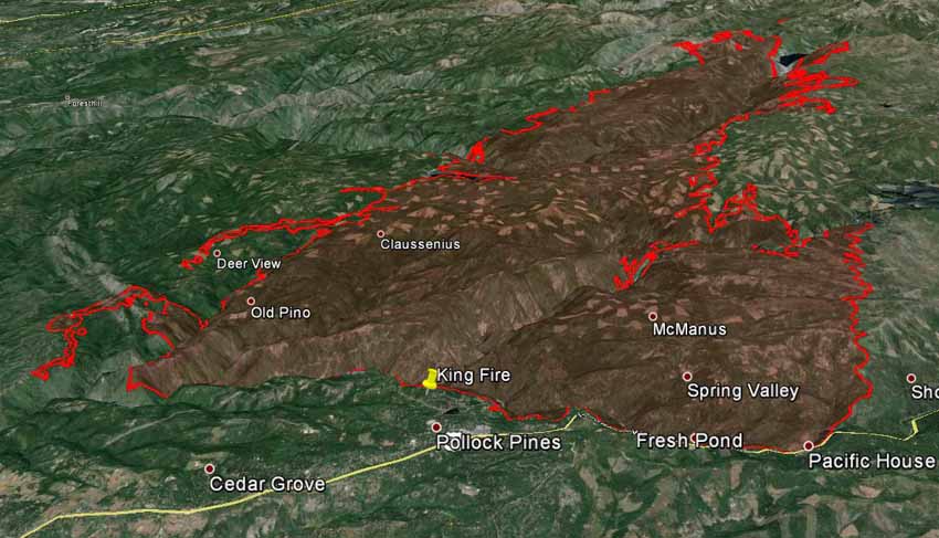
Much of the action on the King Fire Monday was the firing operations on the southwest side. The very ambitions project north of Slab Creek Reservoir intends to burn out the vegetation east of Mosquito Road and Stope Drive, and extends northeast to the Pino Grande, Fairbanks, and Deer View areas.
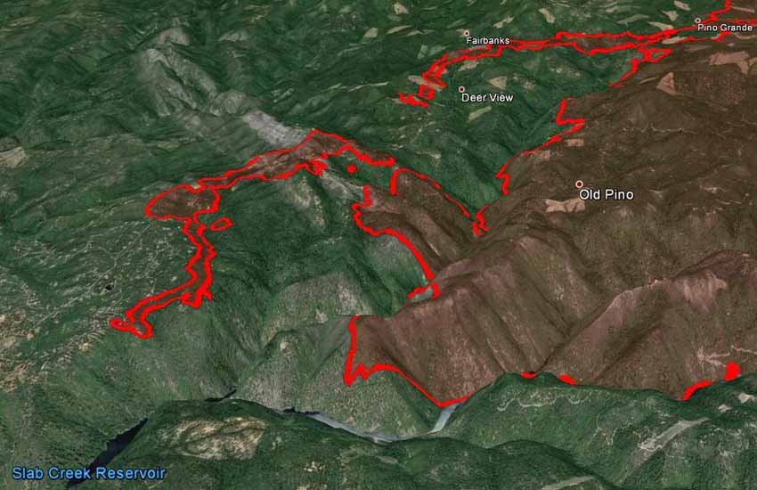
The large spot fire on the east side of French Meadows Reservoir, north of the leading fire edge, is close to full containment. Another firing operation on the east and southeast sides of the fire is being prepared and will be ready to implement on Tuesday. Firefighters say there is a limited window of predicted favorable winds to complete this operation from Union Reservoir to Government Ridge.
A Red Flag Warning will be in effect for the area, from 2 p.m. Tuesday until 8 p.m. Wednesday, for wind and low relative humidity. The warning predicts southwest winds of 12 to 25 mph with gusts up to 35 mph and RHs as low as 15 to 25 percent. A couple of the point forecasts for the area predict winds less extreme than the Red Flag Warning. However weather forecasts in that general location are difficult because of the steep topography, differences in elevation, and the proximity to the Sierra Crest.
The King Fire now has 7,388 personnel assigned. We are not aware of a fire in recent memory with that many people. The 257,000-acre Rim Fire in and near Yosemite National Park last year had over 5,000 personnel, which was a huge number then.
Other numbers:
-
-
- 89,574 acres burned
- 2,830 people evacuated
- 12,000 residences threatened
- 35 percent contained (according to the Incident Management Team)
- 10 residences and 22 other structures destroyed.
-
An Area Command Team (ACT) was dispatched but was released at 6 p.m. on Monday based on a weather forecast of a “wetting rain” across the fire. An ACT does not directly manage fires or other types of incidents, but they supervise Incident Management Teams (IMTs) assigned to individual fires, or they can oversee the management of a very large incident that has multiple IMTs engaged.The ACT works for the Agency Administrator where the incident is occurring. They receive a written delegation of authority and in turn issue one to each IMT they supervise. More information about ACTs.
****
(UPDATE at 7:20 p.m. PDT, September 22, 2014)
The weather forecast for the fire area has been revised to include a Red Flag Warning to be in effect from 2 p.m. Tuesday until 8 p.m. Wednesday. The National Weather Service is predicting southwest winds of 12 to 25 mph with gusts up to 35 mph and relative humidity as low as 15 to 25 percent.
****
(UPDATE at 8:55 a.m. PDT, September 22, 2014)
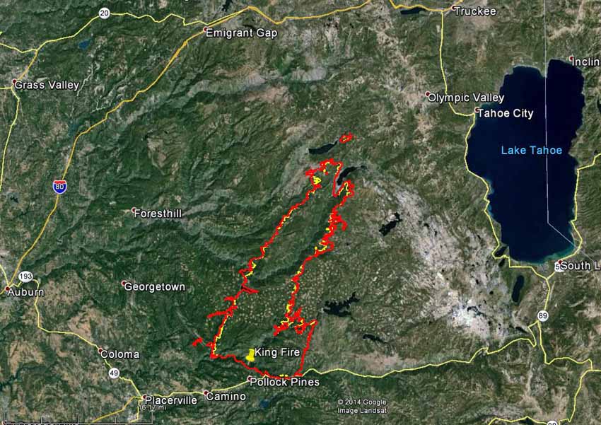
The King Fire between Placerville and Lake Tahoe California grew along most of the perimeter during the last 48 hours, except for the south and southeast sides near Pollock Pines where firefighters have completed firelines. This was in spite of the small amount of rain that fell over the fire Sunday morning (see below). The latest mapping indicates that 87,592 acres have burned, an increase of almost 7,000 acres since the last infrared mapping flight two days ago.
The Incident Management Team has not changed their report on the number of structures burned: 10 residences and 22 other structures damaged or destroyed.

The fire is expected to exhibit low to moderate activity Monday morning but it should increase as the day progresses. Fire behavior is predicted to be individual and group torching, short range spotting, and possible short crown runs. The most significant activity is expected to be on the north portion of the fire. The fire may become very active again, with the predicted return of higher temperatures and lower humidity, with long range spotting, group torching, and short crown runs. The spread is expected to be predominantly towards the northeast due to the wind from the southwest.
****
(UPDATE at 4:16 p.m. PDT, September 21, 2014)
Rain slows the King Fire
Rain that started early Sunday morning slowed the spread of the King Fire between Placerville and Lake Tahoe, California. Light showers passed over the fire area at 1 a.m. PDT and slightly heavier rain fell between 10 a.m. and 1:30 p.m. We checked the total precipitation amounts at four weather stations in the fire area and found these amounts recorded since 1 a.m. Sunday morning: 0.05″, 0.16″, 0.05″, and 0.02″.
This small amount of water is not anywhere near enough to put out the fire, but, with the current relative humidity of 50 to 76 percent, this pause can give firefighters the upper hand for a short while as the fire moves much more slowly. It can enable them to attack the fire from the ground in some areas more aggressively and safely as they construct direct fireline on the edge of the blaze, and it can buy them some time to put in indirect or contingency firelines out ahead of the fire.
The Incident Management Team (IMT) announced more details about the structures that burned on the south end of the fire in the White Meadows area east of Pollock Pines. Preliminary reports from the Damage Assessment Team indicate that 10 residences and 22 other structures were damaged or destroyed. The assessment will continue and these numbers are subject to change. To obtain additional information from the County CAO’s office, residents can call 530-642-7263 or email KingFireElDoradoCounty@gmail.com.
More information from the IMT on Sunday:
Hotshot crews will continue building containment line today around a 350-acre spot fire on the east side of French Meadows Reservoir, ahead of the northern edge of the fire. About a third of the line has already been completed.
The main fire edge is spreading north along the ridge between French Meadows and Hell Hole Reservoir and into the 2001 Star Fire scar, where lighter fuels could naturally slow fire spread. Crews are clearing brush and vegetation in the scar area to make an even more effective barrier.
Crews will also start work today on contingency lines to the north of the fire, clearing brush from Soda Springs Road, so it can serve as a containment line, if needed. They will also cut off stringers — or timber stands aligned with the prevailing southwest winds — where fire could burn rapidly northward. On the western flank, crews are removing vegetation along roads to be used as indirect control lines.
Spike camps will be set up in safe areas closer to the fire line on the northern portion of the fire to reduce travel time for crews. The incident camp post for Zone 1, which includes all areas of the fire north of the Rubicon River, is located in Foresthill.
The weather forecast for the fire area calls for the chance of additional precipitation to gradually decrease to zero overnight Sunday, then increase to 43 percent Monday afternoon before it declines again to zero by Monday night. The weather should be moderate through Thursday, with no extremes of wind, temperature, or relative humidity.
There is no updated map of the fire available, since the fixed wing infrared aircraft was not able to observe the fire last night due to cloud cover. Their sensors can “see” through smoke, but not clouds. The IMT released a fire progression map that displays the spread of the fire, daily, through 1:30 a.m. PDT, September 20, 2014.
The latest stats on the fire:
-
-
- 82,018 acres
- 10 percent containment
- 10 residences and 22 other structures damaged or destroyed
- 2,819 evacuees
- 12,000 residences threatened
- 4 injuries
- 5,235 personnel assigned to the firefighting effort
-
The National Weather Service has issued a “Dense Smoke Advisory” effective through 5 p.m. Monday:
After a period of east winds over the weekend, southwest winds will push smoke back into the Reno-Tahoe area tonight into Monday. The amount of smoke will be highly dependent on the fire activity, but the wind direction will likely bring the smoke into the Tahoe Basin and Western Nevada through most of the week.
Visibility: Less than one mile at times, especially overnight and into the early morning hours.
Impacts: Periods of dense smoke may result in unhealthy air quality with outdoor activities discouraged. Travel may be impacted due to low visibility on Interstate 80, Highway 395, and Highway 50 and Highway 89.
****
(UPDATE at 8:53 a.m. PDT, September 20, 2014)
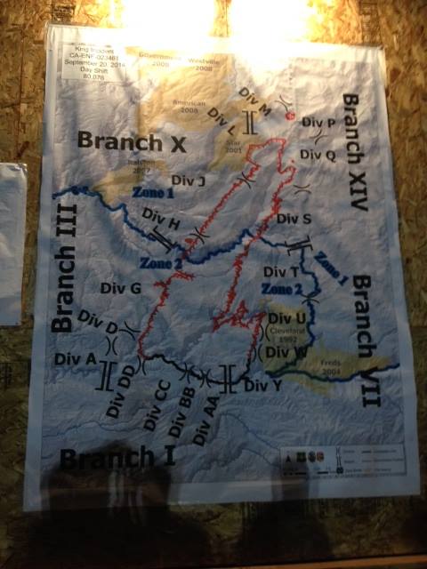
The King Fire, between Placerville and Lake Tahoe, California, was moderately active Friday and Friday night adding another 4,000 to 5,000 acres. Moderate, anyway, when compared to Wednesday’s growth of over 50,000 acres. The current size is listed at 80,994 acres according to the incident management team (another source shows it at 81,994 acres). The IMT is calling it 10 percent contained.
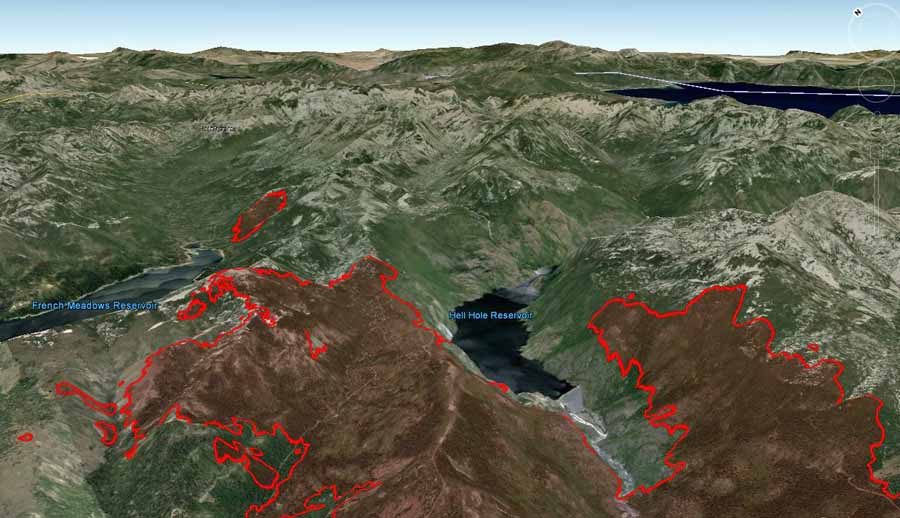
The weather forecast for the 5,000-foot level of the fire area on Saturday shows conditions somewhat more conducive to fire growth, with winds in the late morning and afternoon predicted to be 3 to 9 mph out of the southwest, changing to the west by late afternoon. If firefighters are not able to stop the spread of the head of the fire at the northeast end, there is a possibility the winds and topography could align in the drainages northeast of the French Meadows and Hell Hole Reservoirs, leading to significant fire growth in those areas. (See the 3-D map below.) At the 5,000-foot level the relative humidity Saturday will be in the high 20s, temperature in the high 70s, with a 30 percent cloud cover.
However, point weather forecasts for the fire are tricky and can be misleading due to the huge size of the fire, the varying elevations, the proximity to the Sierra Crest, and differences in topography.
Click on the images below to see larger versions.

****
(UPDATE at 9:20 p.m. PDT, September 19, 2014)
For the first time the incident management team (IMT) that is suppressing the King fire between Lake Tahoe and Placerville has reported that structures have burned. They have not said how many but the the location given was the White Meadows area, which is north of Highway 50 east of Pollock Pines. The Public Information Officers are attempting to notify the home owners before releasing more details.
In another article, we posted a map showing the distribution of smoke from the wildfires in California.
The IMT reported Friday evening that generally there was moderate spread of the fire during the day with isolated areas of rapid fire spread when the wind and slope were in alignment. The north end of the fire had an east wind of 18-20 mph with gusts of 38, pushing the fire to the west. Single and group tree torching was observed. There was a spot fire approximately 2 miles ahead of the main fire front requiring resources to withdraw from the area. The east winds and the up-canyon winds were in opposition, which helped moderate fire behavior through the mid- and lower portions of the fire. Friday night the down canyon winds and the east wind are expected to compliment each other. This could bring increased fire activity.
Poor humidity recovery Friday night, meaning it will remain lower than normal, could also add to the fire activity during the night.
CAL FIRE IMT-5 (Kevin Smith) was in-briefed and transitioned in on Friday. They will be coordinating fire fighting operations on the south portion (Zone 2). California Interagency IMT-5 (Jim Giachino) will be coordinating firefighting operations on the north portion of the fire (Zone-1) and will be relocating further north. The fire will remain in Unified Command. This change is to mitigate the excessive travel time and logistical challenges for resources traveling to the north portion of the fire.
Resources assigned to the fire:
-
-
- 136 hand crews
- 377 engines
- 74 dozers
- 78 water tenders
- 17 helicopters
- Total personnel: 4,936
-
****
(UPDATE at 11 a.m. PDT, September 19, 2014)
The King Fire west of Lake Tahoe California grew by “only” 5,432 acres on Thursday. This increase seems almost paltry compared to the additional 52,400 acres it chewed up on Wednesday. Friday morning the incident management team (IMT) said it has burned 76,376 acres (119 square miles) with 10 percent containment. They have not tried to estimate when the fire will be fully contained.
On Thursday night the fire backed down into the canyons with the evening down slope winds. With the warmer and drier weather today, the fire is expected to be more active with spot fires up to half-mile ahead of the fire in the afternoon, the IMT predicted.
Approximately 21,000 structures are threatened by the fire, according to the IMT. The latest information about evacuations, as of today affecting 2,819 people, can be found at the El Dorado County Sheriff’s Office website. No structures have been reported destroyed yet.
Air tankers and helicopters are being used to slow the rate of spread, influence the direction of spread, and assist in structure protection.
Officials said it was now costing $5 million a day to fight the fire. The total cost through Thursday is $14.8 million, which is paying for the 4,425 personnel, 92 hand crews, 327 engines, 15 helicopters, and numerous air tankers.
When the fire was making the big run Wednesday afternoon up the Rubicon River drainage, the Coyote weather station near Hell Hole Reservoir where the fire ended up that night recorded sustained winds out of the southwest and south-southwest between 10 and 15 mph gusting at 21 to 34 mph. The relative humidity at the weather station, which is at 5,570 feet, bottomed out at 21 percent, while the maximum temperature was 78 degrees.
The weather on Thursday was more moderate: 69 degrees, 35 percent RH, and winds of 4 to 10 gusting at 13 to 20 mph.
The forecast for the fire area (at 5,000′) on Friday includes a change in wind direction — variably from the east, northwest, then east again Friday night, at speeds during the period from 2 to 9 mph. The minimum RH will be 30 percent with a temperature of 77 in the afternoon. This forecast is not conducive to fire spread as rapid as was seen on Wednesday when new spot fires were occurring three miles ahead.
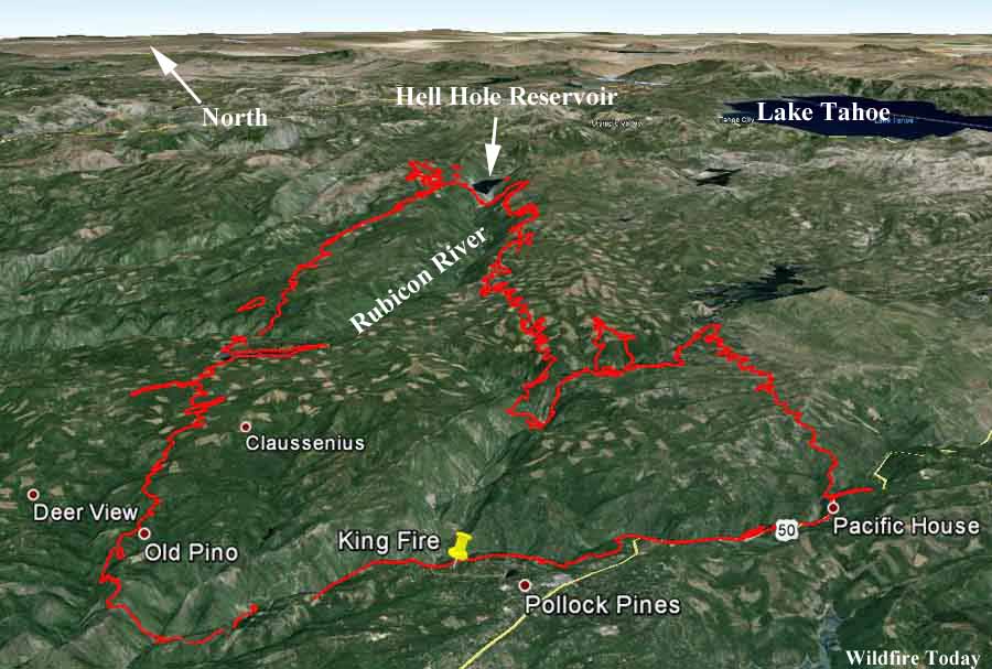
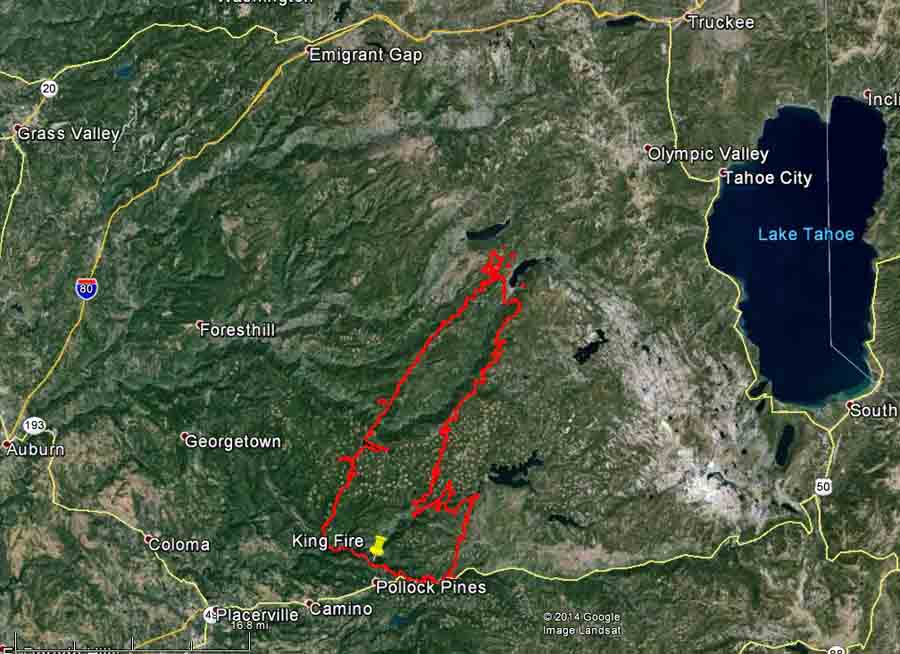
Below are two maps showing the location of the fire at 10 p.m. Thursday night. The first map is 3-D and is looking toward the northeast. The second is a typical overhead map, with north being at the top. Click on the maps to see larger versions.
****
(UPDATE at 7:30 p.m. PDT, September 18, 2014)

The incident management team has revised the size estimate for the King Fire, saying it has now burned 73,184 acres.
Now that the fire has burned into Placer County, it is threatening large hydroelectric facilities and recreation areas near reservoirs. One of the power stations operated by the Sacramento Municipal Utility District has been damaged, cutting off electricity delivery from the utility’s network of reservoirs in the Sierra, according to the Sacramento Bee.
A person has been arrested and charged with arson for starting the King Fire.
****
(UPDATE at 2 p.m. PDT, September 18, 2014)
Below is a recent report from the incident management team describing the fire activity Wednesday night:
The fire continued to burn actively throughout the night. However: due to the day’s extreme fire behavior, steep terrain, inaccessibility, variable wind direction, and darkness it was unsafe to approach the north portion of the fire to directly observe the fire behavior. [Through] field observations and Infrared imagery it was determined that the fire made a run of over ten miles to the north between the hours of 1600 and 0600. Spot fires were observed up to three miles ahead of the main fire front.
****
(UPDATE at 7:44 a.m. PDT, September 18, 2014)
King Fire almost triples in size
The photo of the pyrocumulus over the King Fire that we posted yesterday, below, was captured during a period when the fire was making a very large run to the northeast. On Wednesday the fire added 52,400 acres, growing from 18,544 acres to 70,944 acres, almost tripling in size in 24 hours, running for 16 miles through the El Dorado National Forest. It is now between Hell Hole and French Meadows Reservoirs in Placer County, 12 miles from Olympic Valley, 13 miles from the west shore of Lake Tahoe, and 20 miles from Truckee.
Evacuations have affected 2,155 people. The El Dorado County Sheriff’s web site has more details.
The fire is being fought by 3,700 personnel. Last year the 257,000-acre Rim Fire at Yosemite National Park had over 5,000 people assigned — this fire may come close to that personnel figure, especially if it continues to add over 50,000 acres a day.
Other resources assigned to the fire include 299 engines, 88 hand crews, 15 helicopters, 49 dozers, and 68 water tenders.
King Fire Information Line: (530) 647-5218
****
(UPDATE at 5:44 p.m. PDT, September 17, 2014)
The King Fire east of Placerville, California has been very active this afternoon, as evidenced by this huge pyrocumulus cloud over the convection column of smoke today.
MT @NWSSacramento: Pyrocumulus cloud at the #KingFire this afternoon, viewed from NWS Sacramento. #cawx #wildfire pic.twitter.com/WNWWP46tOt
— Sarah Boon (@SnowHydro) September 17, 2014
****
(UPDATE at 8:10 a.m. PDT, September 17, 2014)
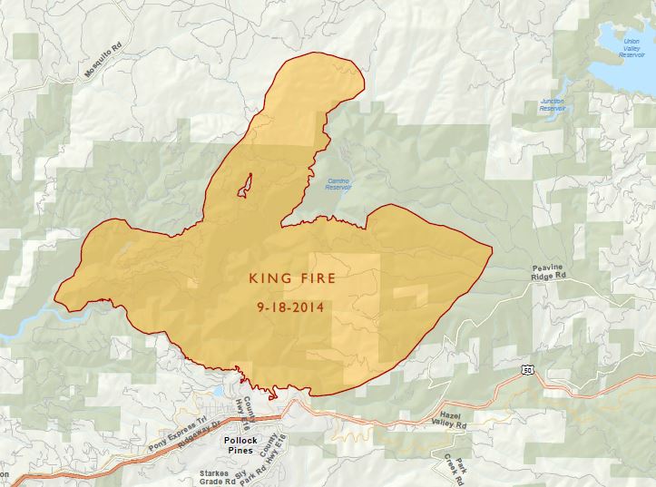
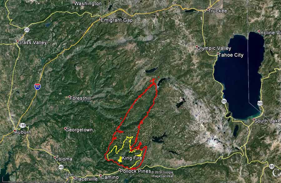
Above is a screen grab of the latest map of the King Fire east of Placerville, California. To see the full 742 KB .pdf map, download this file: King Fire map 2014_09_17 If you download the file, you may notice that the map is dated tomorrow, September 18. We’re fairly certain it should read September 17. Evacuations are ongoing. The El Dorado County Sheriff’s Office has the details.
Here is the latest information about the King Fire from the Incident Management Team Wednesday morning: Size: 18,544 acres based on an infrared mapping flight last night Containment: 5% Personnel: 2,519 Evacuations: 2,150 people Number of structures threatened: 1,632 Last night (Tuesday) the fire was active. Humidity recovery was exceptionally poor [the humidity remained low], but the fire did mostly stay on the ridge tops. The fire is expected to be active again today [Wednesday] due to expected gusty and erratic winds, mostly from the southwest. Fire growth is expected mostly to the N/NE.
God bless them. RT @TrevorHughes: Hundreds of firefighters assembled for morning #KingFire briefing. pic.twitter.com/AjpzdfXJkP — Vanessa Kelly (@VanessaKellyAut) September 17, 2014
****
(UPDATE at 2:20 p.m. PDT, September 16, 2014)
The Incident Management Team made this map available on the National Forest InciWeb page this afternoon: 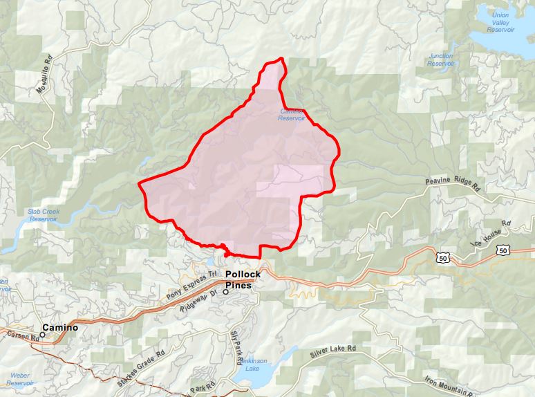
****
(UPDATE at 9:15 a.m. PDT, September 16, 2014)
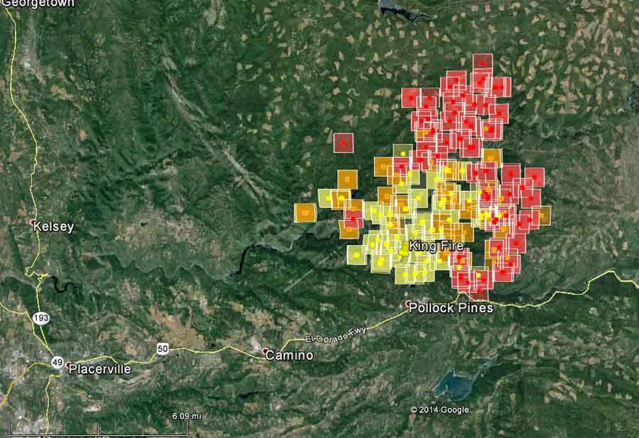
The King Fire east of Placerville, California is requiring evacuations north of the community of Pollock Pines. Tuesday morning the fire is still spreading to the east and north and is listed at 11, 570 acres with 5 percent containment. The fire is burning in steep terrain located in the South Fork American River Canyon and Silver Creek Canyon. The fire started out as a CAL FIRE responsibility fire and later burned onto the El Dorado National Forest, so we may not see any good maps of the fire any time soon. Neither of the official sources of detailed information from CAL FIRE or the U.S. Forest Service have mentioned by 9:39 a.m. on Tuesday September 16 that 12 firefighters were overrun by the fire on Monday, deployed fire shelters, and had to run from the fire, eventually making it to a spot after a long run and hike where they could be extracted by helicopters. A dozer also burned in the incident. CAL FIRE sent out a tweet that briefly confirmed that the entrapment occurred.
****
(UPDATE at 4 p.m. PDT, September 15, 2014)
A CAL FIRE Captain and an inmate crew, 12 people total, were overrun by the fire and deployed their fire shelters. After initially deploying, they ran and later walked quite a distance, guided by the Helicopter Coordinator overhead in a helicopter, until they reached a point where they could be picked up by helicopters. No major injuries were reported, however it just occurred at about 1 p.m. today and not all the details are known. Three ambulances were requested to meet them at the airport where the helicopters landed. A dozer was also burned over. The operator was “accounted for”; no more details are available about the operator. More details are in another article.
****
(UPDATE at 9:20 a.m. PDT, September 15, 2014)
The King Fire 11 miles east of Placerville, California has been spreading rapidly with long-range spotting north of the community of Pollock Pines. There is a significant threat to the Whites Meadows, Spring Valley, Camino, and Pollock Pines communities. Areas under a mandatory evacuation order include White Meadows Road, Spring Valley Road, the eastside of Forebay Road from King of the Mountain Road to Pony Express Trail, and all roads north of Pony Express Trail from Forebay road east through Bullion Bend. Other areas are under a voluntary evacuation.
#KingFire is now at 3,900 acres. Smoke continues to billow from both sides of the American River Canyon. pic.twitter.com/Hd9KyZxOo9 — Brian Hickey (@kcraBrianHickey) September 15, 2014
The fire is listed at 3,900 acres with 10 percent containment. It is being managed in a unified command with the Eldorado National Forest and CALFIRE. Califormia Incident Management Team #5 (Giachino Incident Commander) as been assigned and will in-brief at noon today.
****
(Originally published at 8:42 p.m. PDT, September 14, 2014)

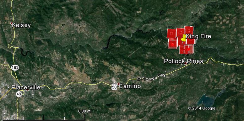
The King Fire is requiring evacuations of residents north of California Highway 50 near Pollock Pines 11 miles east of Placerville, California. (See the map of the fire below.) Firefighters are having to deal with rapid rates of spread and long-range spotting. It is being managed under a Unified Command with CAL FIRE and the El Dorado National Forest. The fire can be seen from Sacramento which is 50 miles west of the area. CAL FIRE reports that 500 structures are threatened and mandatory evacuations have been ordered for the east side of Forebay Road between King Mountain Road and Pony Express Trail; and for White Meadows Road. The El Dorado County Sheriff’s Office website has detailed evacuation information. As of late Sunday afternoon the fire had burned 2,500 acres on both sides of the American River. Daniel Berlant of CAL FIRE said 800 personnel are assigned.
We can see the smoke plume and #pyrocumulus from the #KingFire which is ~50miles away! Also visible on radar. #cawx pic.twitter.com/XjpLzyS1jx — NWS Sacramento (@NWSSacramento) September 14, 2014
#king fire #Eldorado County , no looking good pic.twitter.com/jYyeBGd7KB — Leticia Lumbreras (@LeticiaLum01) September 15, 2014

7,388 personnel assigned as of Sept 23. Anyone know of a fire with more people on it?
As we focus on the King two dangerous starts yesterday (probably more State wide) Tuolumne/Calaveras unit near Arnold and AEU/ENF Mormon Immigrant Trail, fifteen miles south/east of Pollock Pines. Timber, three and 10 acres, contained. Blue-suiters, policy for some agencies. These are the ‘leaders” everyone else should be loading-up for their operational period. If your working with another agency on the same division or next to it gives you a change to identify that person (name tag-patch) meet and communicate. This allows you to get a feel of experience levels. A division group from Oklahoma would probably feel more comfortable with the assignment knowing the leaders are from the area and may have a better understanding of local factor. Of course it works both ways. In Rome do as the Romans do.
Good luck to all crews, be safe, take no chances. No house, no tree is worth a life. 10&18 … a wildfire firefighter knows.
Here is an online map with the King fire perimeter and wind data. The map is zoomed out so you can compare the size of the fire to Lake Tahoe. The map is displayed by Gmap4 which is an enhanced Google map viewer I developed.
Each time you open this map link it will display the most recent information hosted on government servers and showing (1) the fire perimeter [comes from GeoMAC], (2) MODIS [satellite] hotspots and (3) wind direction and speed as of 1 to 2 hours ago. To see the map legend click the link in the upper left corner that says “About this map”.
This map link will work in almost any browser on almost any device. Note – Your browser must be online. If you open this link with a smartphone, tablet or other mobile device then you will automatically see a touch-friendly interface.
To center the map at your location, touch Menu ==> My location (mobile only). The symbol you see on the map will now follow you just like a GPS. Touch the symbol to see the coordinates for your location.
To see high resolution topographic maps, open the basemap menu (button in upper right corner) and select “t4 Topo High” (you might need to zoom in).
If you open the basemap menu and go down to the “Overlay” section then you can turn various GIS layers on/off. A layer with a higher number will be on top of any layer with a lower number. A layer without any number is “off” but can be turned on with a click/touch. Some GIS data only displays at certain zoom levels.
Gmap4 homepage: http://www.mappingsupport.com/p/gmap4.html
Gmap4 default map: http://www.mappingsupport.com/p/gmap4.php
Thanks for the briefing map! And interesting to see the prior burns on it.
Just a couple of passing thoughts about this fire: first, reading the Incinet report about yesterday’s extreme fire behavior and 3-mile spotting, I wonder if the Air Show was scaled back, given the winds and ineffectiveness of retardardant under those conditions; and then, looking at the “Twitter” photo of the morning briefing, where are all of the Yellow shirts? Looks like lots of “blue-suiters” not ready to depart for the fireline?
Listening to the scanner gives good insights to the difficulty fighting the fire. Air Attack explains his strategy to the various people he talks to which lets us eavesdroppers understand even though there are a lot of resources available, not all can be used due to terrain, smoke and squirrelly winds. Flame lengths three times tree height and spotting miles ahead of the main front don’t help.
As a side note, I came across this video on youtube – driving from Swansboro, down the Mosquito Road, cross the Mosquito Bridge to Placerville.
This morning they’re laying down retardant just east of Swansboro.
http://www.youtube.com/watch?v=TMkXrMHX20E
I’m not sure I understand the point of linking to the video. There is no fire. It was uploaded to YouTube in 2010. Maybe Mr. or Ms. Miller wanted us to see what the area looks like.
Having lived in El Dorado county, I can say Mosquito road is typical of the roads in the fire area. Much of the terrain is steep enough to stand upright and touch the ground with your outstretched hand.
no … no fire there … just to see the area …
Interesting radio traffic this afternoon – sounds like a lot of it is between a lead plane (the woman’s voice) and various tankers? Comments? The videos I’ve seen of their flying is always impressive.
Yubanet has a map on their page for this fire.
http://yubanet.com/nevada/King.php
And for those of you who love listening to air attack, King Fire Air Attack is on http://www.broadcastify.com/listen/feed/559/web/?rl=rr
El Dorado County Fire dispatch is also on this feed.
http://pollockpinesweathercam.com/
This weathercam shows the El Dorado county fire station at Pollock Pines. At the moment, it seems a CDF strike team is staged there as well as a yellow fire engine from somewhere. Not enough detail to read engine IDs.