(Our previous article about the Rocky Fire near Clearlake, California had been updated many times and was becoming large, so we are starting fresh with this article beginning August 2. It will continue to be updated.)
(An updated report on the Rocky Fire was published the morning of August 5, 2015)
****
(UPDATE at 6 a.m. PT, August 4, 2015)

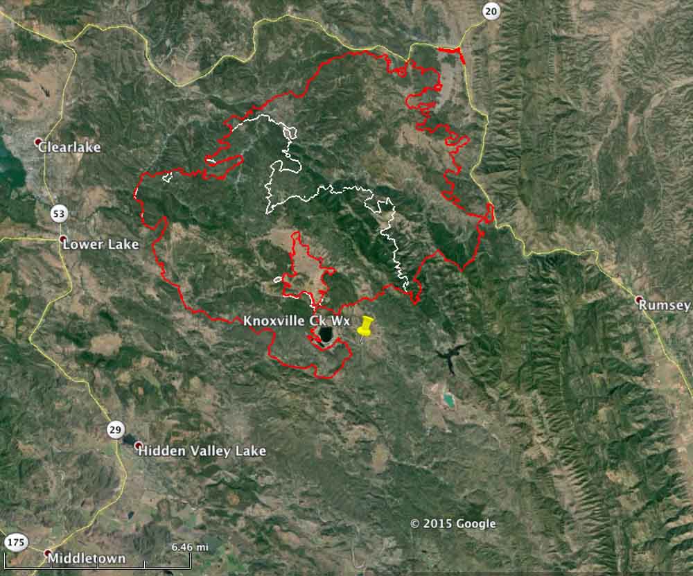
Yesterday we wrote that firefighters had been able to keep the Rocky Fire from crossing Highways 20 and 16. That changed Monday afternoon when airborne burning embers northeast of Clearlake, California started multiple spot fires across Highway 20. Some of the new fires merged (see the map above), leaving two large fingers of fire, one of them three miles long, heading north coming within three miles of Indian Valley Reservoir.
The good news is that the fire grew very little in other areas. It is still primarily west of Highway 16 and the perimeter on the south and southwest sides has expanded only a small amount over the last 24 hours.
Tuesday morning at 2:30 a mapping flight determined that the fire has blackened 68,810 acres.
CAL FIRE is still reporting 24 residences and 26 outbuildings destroyed by the Rocky Fire. Evacuations have affected at least 13,118 residents in 5,530 residences.
On Monday the Air National Guard’s Modular Airborne FireFighting System (MAFFS) C-130 air tankers recently activated flew 7 sorties dropping 20,476 gallons of fire retardant on the Rocky Fire.
The spotting across Highway 20 occurred in the afternoon during a period when winds out of the south were gusting up to 18 mph and the relative humidity reached a low of 16 percent. The forecast for Tuesday is for 83 degrees, 27 percent RH, winds out of the east then southeast at 2 to 7 mph, and mostly cloudy skies in the afternoon until 5 p.m. These weather conditions should moderate the fire activity compared to what firefighters saw on Monday.
****
(UPDATED at 6 a.m. PT, August 3, 2015)

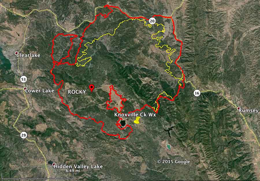
Firefighters continue to battle the Rocky Fire east of Clearlake and Lower Lake, California, which has grown to 60,000 acres. They are having some success on the north and east sides where the spread of the fire has been stopped in some places, for now, along Highways 20 and 16. But there is still a great deal of uncontrolled fire edge that must be dealt with.
The two highways, 20 and 16, are closed. CAL FIRE reports that evacuations are impacting over 12,000 residents, but that number has not been updated in a while. The number of residences destroyed, according to their information, remains at 24.
There was good relative humidity recovery overnight when it increased to 84 percent by 5 a.m., but it will slowly decrease on Monday to a low of 24 percent by 3 p.m. The maximum temperature will be 85 and in the afternoon the 2 mph southeast wind will increase to 10 mph out of the southwest around 5 p.m. These conditions on Monday morning will give firefighters a chance to make some headway on containing the fire, at least until mid-afternoon.
#rockyfire I’m on Olympic and Burns Valley Rd in the city of #Clearlake. #wildfire pic.twitter.com/mxtBPeLbEZ — Valerie Lemke (@FreelanceRoad) August 3, 2015
**** (UPDATED at 8:39 p.m. PT, August 2, 2015) CAL FIRE is calling the Rocky Fire east of Clearlake, California 54,000 acres and 5 percent contained as of Sunday evening.
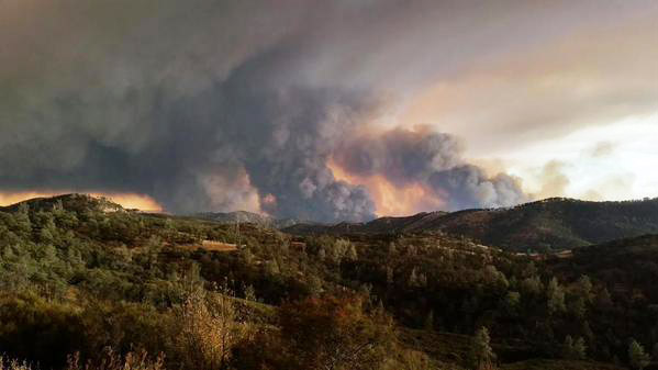
Plume of smoke from #RockyFire in #California. http://t.co/YN7Bq1K9zT #CalWildfires (Pic @abc7newsBayArea) pic.twitter.com/aGA3qaVw03 — Ed Joyce (@EdJoyce) August 3, 2015
****
(Originally published at 9:35 a.m. PT, August 2, 2015)
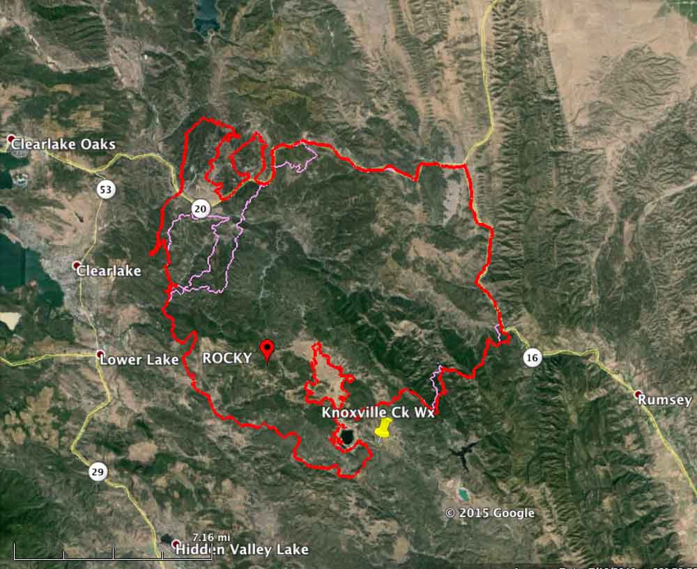
The Rocky Fire east of Clearlake, California more than doubled in size on Saturday. CAL FIRE reported that it had burned 22,500 acres on Saturday morning, and a mapping flight at 2 a.m. Sunday determined that it had exploded, again, and has now blackened 47,000 acres. Two highways in the area are closed, Highways 20 and 16. (See the map below.)
The weather conditions on Saturday were fairly conducive to significant fire spread — 95 degrees, 21 percent relative humidity, and southwest winds at 8 mph gusting up to 17. The forecast for Sunday is somewhat more moderate — 90 degrees, 32 percent RH, and winds switching from the west to south at 2 mph increasing to 9 mph in the afternoon.
Combined with low vegetation (fuel) moisture, another 25,000 acres went up in smoke Saturday as the fire spread to the north and east coming close to, and in some areas reaching, Highway 20 on the north and 16 on the east. CAL FIRE reported at 7:45 Sunday morning that the fire had not crossed the roads. Firefighters were burning out or backfiring ahead of the fire in some places along the highways.

The Rocky Fire has destroyed 24 residences and 26 outbuildings, according to CAL FIRE. Evacuations have impacted over 12,190 citizens living in 5,201 residences.


Your new link takes me to the old page for 8/4/15. I tried refreshing my browser and that didn’t help. When I look closely at the URL for the new page… it is the link to the old page
We really miss your update for today (8/5/15). Your maps showing the previous and most recent borders of the fire area superimposed are the best representations of the fire’s progress I have ever seen. I also avidly read your comments about the weather conditions for the previous and next day. It gives us an appreciation of what the wonderful fire fighting crews are experiencing.
Can’t wait for the next update.
Thanks Jeff. Today, August 5, we started the third article on the Rocky Fire. We’re going to continue doing this every couple of days because otherwise they can become long, unwieldy, and will take too long to load.
If you don’t see an update, look at the top of the last article where there will probably be a link. Otherwise, go to our home page and check there by scrolling down.
I’ve really appreciated the coverage and maps you’ve provided on the Lake County Rocky Fire, thank you!
You are very welcome, Rose.
I JUST WANT TO THANK ALL THE FIRE FIGHTERS AND ANY OTHER PERSONEL FOR DOING SUCH A WONDERFUL JOB. I KNOW YOU ARE DOING YOUR VERY BEST WE LOVE YOU ALL
THANK YOU SO VERY MUCH