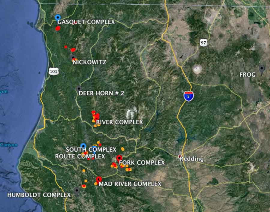
Over 10,000 firefighters are battling 19 active fires in California. The Rocky Fire near Clearlake that attracted the most attention that burned 43 homes and required thousands to evacuate has rapidly increasing containment and repopulation has started. The other 18 fires are mostly scattered around the north half of the state, with the most activity occurring in the northwest corner on the Six Rivers and Shasta-Trinity National Forests.
These two maps show heat that was detected on wildfires by a satellite within the last 24 hours — one map has fire names and the other is naked. The red dots are the most recently detected heat sources.

Below are quick summaries of the 19 fires provided by CAL FIRE:
**CAL FIRE Incidents**
Rocky Fire, Lake, Colusa & Yolo County
East of Lower Lake
*69,600 acres – 45% contained
*Repopulation efforts started
Humboldt Lightning Fires, Humboldt County
Throughout Humboldt County
*75 fires totaling 4,062 acres – 35% contained
*Evacuations lifted in the Blocksburg
Lowell Fire, Nevada County
You Bet area, west of Alta
*2,304 acres – 90% contained
**Unified Command Incidents**
Fork Complex, Trinity County
US Forest Service – Shasta-Trinity National Forest / CAL FIRE
South of Hyampom
*14,434 acres – 9% contained
**Federal Incidents**
River Complex, Trinity County
US Forest Service – Shasta-Trinity National Forest
New River Drainage, near Denny
*10,912 acres – 1%
South Complex, Trinity County
US Forest Service – Shasta-Trinity National Forest
Near Hyampom, south of Hwy 299
*14,071 acres – 3% contained
Route Complex, Humboldt & Trinity County
US Forest Service – Six Rivers National Forest
West of Hyampom
*14,709 acres – 10% contained
Mad River Complex, Trinity County
US Forest Service – Six Rivers National Forest
Near Ruth Lake
*15,760 acres – 10% contained
Dodge Fire, Lassen County
Bureau of Land Management – Northern California District
*11,400 acres – 30% contained
Mendocino National Forest Lightning Fires, Mendocino County
U.S. Forest Service – Shasta-Trinity National Forest
*15 fires totaling 204 acres
Nickowitz Fire, Del Norte County
U.S. Forest Service – Six Rivers National Forest
*174 acres – 45% contained
Gasquet Complex, Del Norte County
U.S. Forest Service – Six Rivers National Forest
on the Gasquet Ranger District
*9 fires totaling 1,000 acres – 2% containment
Cabin Fire, Tulare County
US Forest Service – Sequoia National Forest
8 miles northeast of Camp Nelson
*4,713 acres
Rough Fire, Fresno County
US Forest Service – Sierra National Forest
2 miles north of the Kings Wild and Scenic River
*450 acres
Frog Fire, Modoc County
US Forest Service – Modoc National Forest
Southwest of Lava Campground
*4,782 acres – 75% contained
Willow Fire, Madera County
US Forest Service – Sierra National Forest
Southeast of Bass Lake
*5,702 acres – 95% contained
Chorro Fire, Ventura County
U.S. Forest Service – Los Padres National Forest
North of Ojai
*282 acres – 95% contained
Deer Horn 2 Fire, Humboldt County
Bureau of Indian Affairs – Hoopa Fire Department
Deerhorn Ridge in Hoopa
*125 acres – 90% contained
Washington Fire, Alpine County
US Forest Service – Humboldt-Toiyabe National Forest
South of Markleeville
*17,790 acres – 99% contained
