(This article is no longer being updated, but there was an update on Wildfire Today on September 3, 2015.)
****
(UPDATE at 6:45 a.m. PT, August 24, 2015)
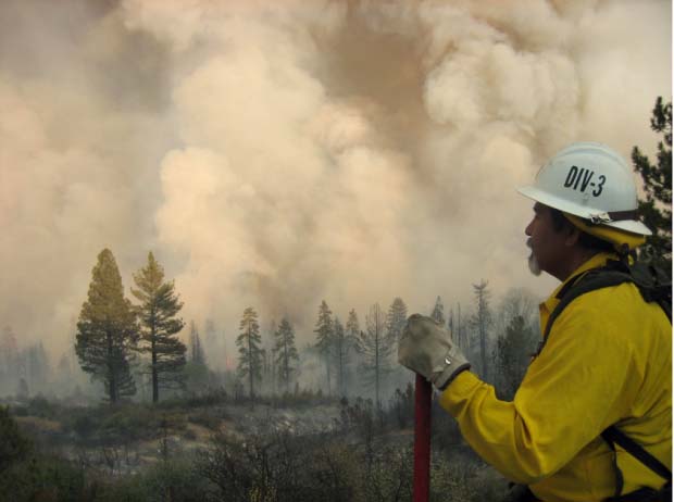
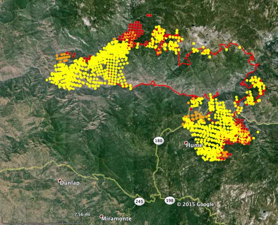
The Rough Fire just east of Hume Lake, California was fairly active again Sunday afternoon in multiple areas. As a result of fire activity and firing operations, the burned area increased approximately 2,000 acres to a total of 49,440 acres or 77 square miles.
Direct fire suppression continued southwest of Hume Lake near Landslide Campground. The objective of this operation is to stop the southern spread south of Hume Lake and east of the Kennedy Grove area. Aircraft continue to be used for these direct suppression operations.
Crews conducted hand firing near Balch Camp on Sunday. The fire made a run up canyon and burned laterally across the slope approximately ¾ miles from Balch Camp. Retardant is being dropped from helicopters to build a retardant line from the river up slope to check the fire spread.
The Grant Grove and Wilsonia areas of Kings Canyon National Park will reopen in stages Monday and Tuesday. At noon on Monday the General Grant Tree, Panoramic Point, park trails, John Muir Lodge, Grant Grove Cabins, restaurant, market, and gift shop will open. On Tuesday at 8 a.m., the Kings Canyon Visitor Center will reopen, and at noon Tuesday Sunset Campground will open.
****
(UPDATE at 11:15 a.m. PT, August 22, 2015)
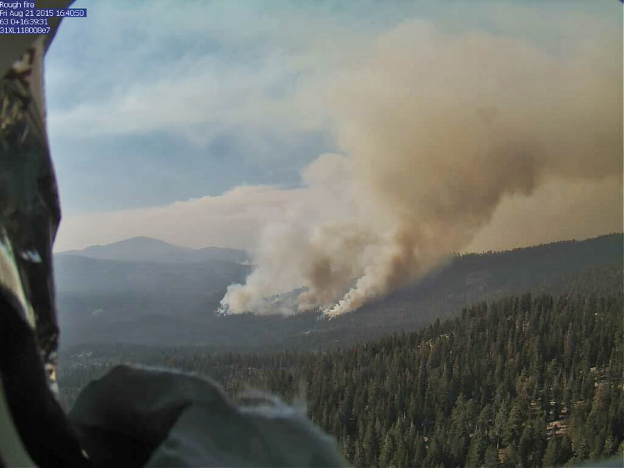
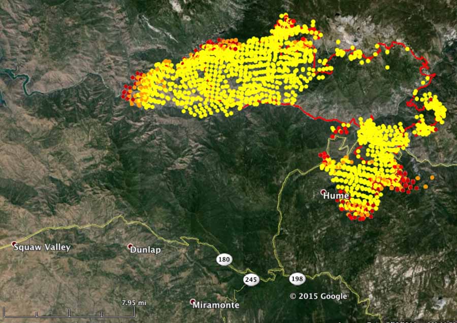
The Rough Fire at Hume Lake, California, 36 miles east of Fresno, has spread south of Hume Lake and continues to grow on the west side north of Kings River and Highway 180. The incident Management Team is calling it 47,079 acres. Approximately 1,484 personnel are assigned to the incident.
As of Saturday morning the Grant Grove and Wilsonia area of
Kings Canyon National Park is closed to visitors. Highway 180 is closed beyond the junction of Highway 198 (Generals Highway). Visitors to Sequoia and Kings Canyon National Parks can still travel the Generals
Highway from the Big Stump entrance station to the Ash Mountain entrance station.
****
(UPDATED at 8:45 a.m. PT, August 21, 2015)
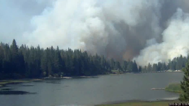
The Rough Fire has approached very close to the community of Hume Lake, 36 miles east of Fresno, California. It has been burning for three weeks but in the last few days the intensity increased as it crossed the Kings River and Highway 180. It has been most active on the south and west sides, at times spreading under the cover of dense smoke that has kept firefighting helicopters and air tankers on the ground. Late in the day on Thursday the wind direction shifted, blowing some of the smoke away from Hume Lake, allowing helicopters to use lake water to help slow the advance of the fire.
The incident management team is saying the fire has burned 39,400 acres.

****
(UPDATED at 8:05 p.m. PT, August 19, 2015)

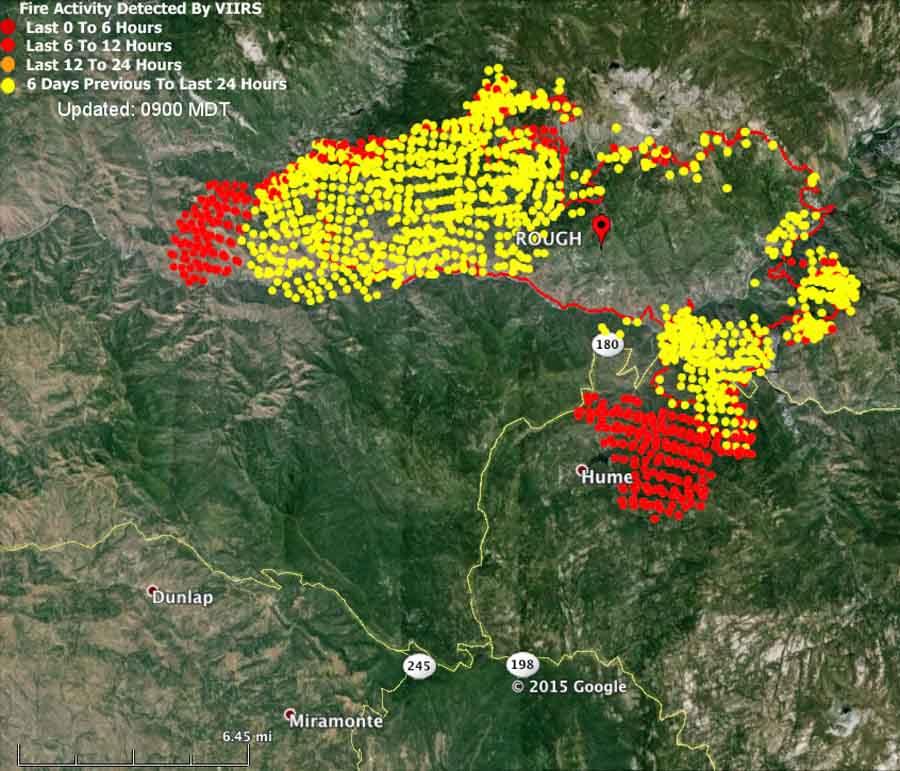
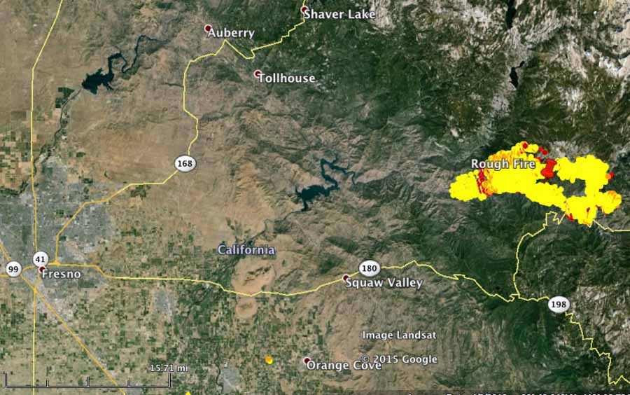
The map of the Rough Fire, above, has fire perimeter data from 1:30 a.m. PT, August 19, 2015.
****
(UPDATED at 12:36 p.m. PT, August 19, 2015)
The National Weather Service revised the forecast for the fire area for Wednesday afternoon. Instead of an ENE wind switching to a west wind at about 10 a.m., now they are predicting an east-component wind will blow all day until 10 p.m. The speed will be 10 mph until 6 p.m. when it decreases to 1 to 3 mph. There was virtually no wind at the Cedar Grove weather station from 8 p.m. Tuesday night until 10 a.m. on Wednesday. The temperature should top out at about 95 degrees Wednesday and the relative humidity is expected to drop to 17 percent by 2 p.m.
An east wind could push smoke into the Hume Lake area and also cause the fire to grow closer to the community.
****
(UPDATED at 5:22 a.m. PT, August 19, 2015)

New maps are available of the Rough Fire burning three miles northeast of Hume Lake, California. A satellite that detects heat confirms that the fire crossed Highway 160, north to south, and is established on a steep north-facing slope above the Kings River.

Tuesday night after 6 p.m. there was virtually no wind recorded at the Cedar Grove weather station 7 miles east of the fire and by 4 a.m. PT the relative humidity had risen to 57 percent — conditions that do not encourage rapid fire growth.
Highway 180 is closed to the public from the Hume Lake intersection to Cedar Grove in Kings Canyon National Park.
The fire is being managed by the South Central Sierra Type 2 Incident Management Team, with Incident Commander David Cooper. They reported Tuesday evening that the fire had burned 24,200 acres.

****
(Originally published at 5:43 p.m. PT, August 18, 2015)
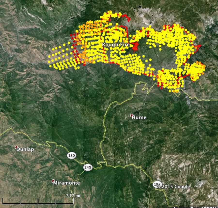
Firefighters have been managing the Rough Fire in the Sierra National Forest since it started on July 31, but today it could be opening a new chapter as it headed south and crossed the Kings River and Highway 180.
Mandatory evacuation orders are in effect for the Hume Lake area, which is about 3 miles southwest of where the fire crossed the highway. This evacuation affects approximately 1,000 people living, working and recreating around Hume Lake.
To date, 23,600 acres have burned, $7.8 million has been spent, and there is 0% containment 19 days after the fire started.
The Rough Fire is about 36 miles east of Fresno, California.
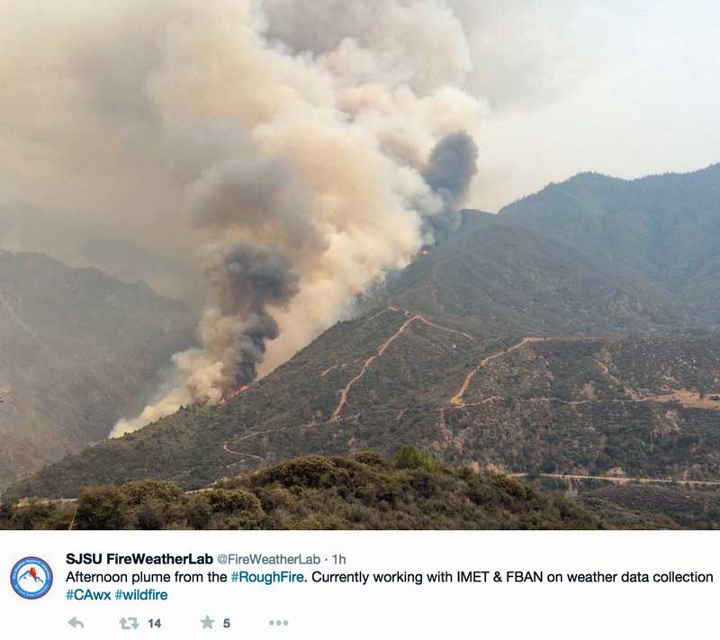
On Tuesday the Cedar Grove weather station 7 miles east of the fire recorded a temperature of 91 degrees, the relative humidity was 14 percent, and in the afternoon the wind was out of the west at 3 to 7 mph with gusts of 18 to 21 mph.
The forecast for the fire area for Wednesday predicts 95 degrees, RH of 17 percent, and afternoon winds of 10 mph out of the west. The wind Wednesday afternoon should push the fire away from Hume Lake, however from about 2 a.m. until 10 a.m. on Wednesday an ENE wind at 3 mph is predicted which could cause it to grow closer to the Hume Lake area.
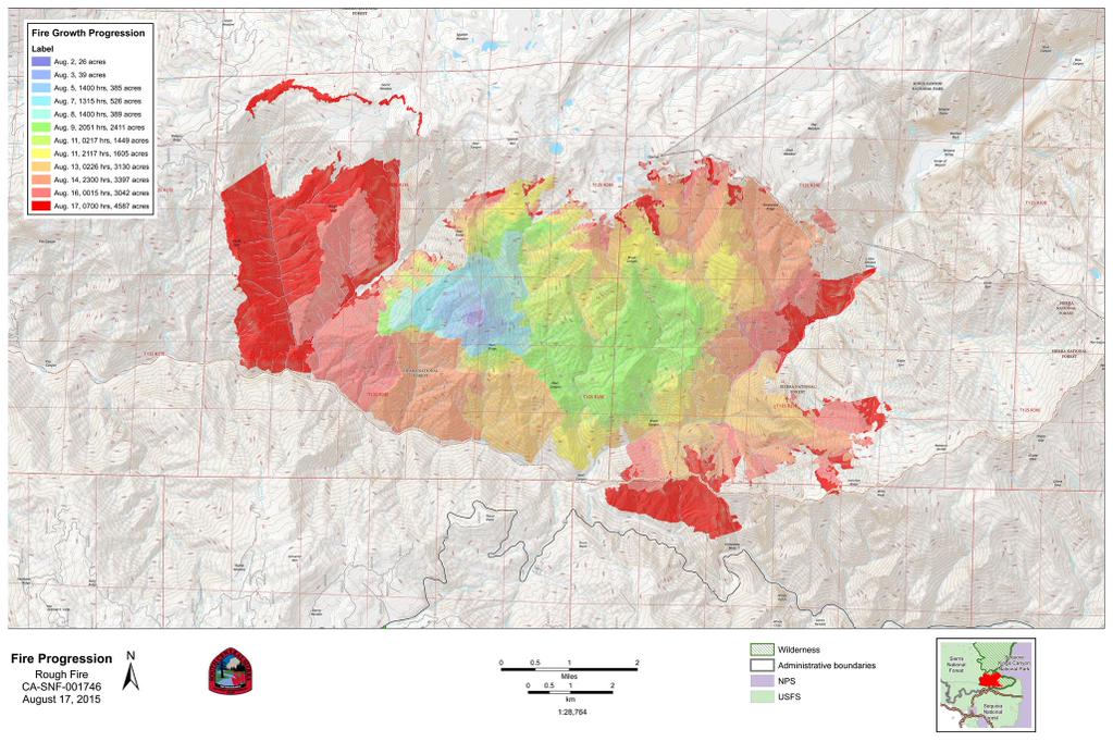
The progression map below tracks the spread of the fire since it started. Click on it to see a larger version.

We have a cabin at Hume and the worst is always the “Not Knowing”. Your website offers comfort in “knowing”. Thank you.
Thank you, and I hope everything works out well for your place.