Smoke map and Red Flag Warnings, Aug. 28, 2015

Red Flag Warnings, Aug. 28, 2015

The National Weather Service has issued Red Flag Warnings or Fire Weather Watches for areas in California, Washington, Nevada, Wyoming, Idaho and Montana.

The map was current as of 9 a.m. MDT on Friday. Red Flag Warnings can change throughout the day as the National Weather Service offices around the country update and revise their forecasts and maps. For the most current data visit this NWS site or this NWS site.

Heavy smoke from northwestern fires continues to drift into Canada, although as of Friday morning, the smoke was less severe than it had  been in previous days.

Smoke Map, Aug. 28, 2015. AIRNow.gov

To see the most current smoke reports on Wildfire Today, visit the articles tagged “smoke” at https://wildfiretoday.com/tag/smoke/

U.S. Forest Service to begin “fire transfer” by the end of August

Anticipating a budget shortfall, the U.S. Forest Service has begun transferring money from its various branches to fuel its dwindling fire suppression fund.

This summer, the agency announced that for the first time in its 110-year history, it will spend more than 50 percent of its budget on fire suppression, a figure that has shot up from around 16 percent in the mid-1990s.

The first withdrawals from programs were set to begin this week, according to an internal memo sent to Forest Service employees from Chief Tom Tidwell. The memo, sent on Aug. 25, said that the agency has only $174 million left in its budget for fighting wildfires, of $1.01 billion that was set aside.

The Forest Service will transfer the funds in two increments, the first of $250 million this week and the second of $200 million at a later date.

“The Washington Office budget staff will work directly with your budget staffs to collect information on significant impacts these transfers will have on your units,” Tidwell said in the letter.

Historically, fire prevention programs have suffered due to the fire transfer, also known as fire borrowing. In 2014, the Forest Service released a state-by-state study showing the impacts of the transfer on various land management projects throughout the country.

“The multitude of benefits that forests provide to the public—including clean air and water, recreation, forest products, and jobs—are at risk because of the broken federal wildfire funding system,” said Florida State Forester Jim Karels in a statement on Friday. Karels is president of the National Association of State Foresters.

“It’s too late for Congress to act to prevent transfers this fire season. But Congress must act soon to ensure this is the last time we rob resources to fund fire suppression at the expense of our nation’s forests’ long-term health.”


Smoke map and Red Flag Warnings, Aug. 27, 2015


Red Flag Warnings, Aug. 27, 2015. noaa.gov

The National Weather Service has issued Red Flag Warnings or Fire Weather Watches for areas in Washington and Montana.

The map was current as of 9 a.m. MDT on Thursday. Red Flag Warnings can change throughout the day as the National Weather Service offices around the country update and revise their forecasts and maps. For the most current data visit this NWS site or this NWS site.

Smoke map, Aug. 27 2015. AIRNow.gov.

Heavy smoke from northwestern wildfires is continuing to blanket southern Canada. Unhealthy levels of smoke have been forecasted for central and western Canada, in Alberta and British Columbia, as well as northern Washington, Idaho and Montana.

Air Quality map, Aug. 27, 2015, AIRNow.gov

To see the most current smoke reports on Wildfire Today, visit the articles tagged “smoke” at https://wildfiretoday.com/tag/smoke/

Google Earth flyover of Washington complex fires

Kenji Kato has been posting daily Google Earth flyover updates on the Washington wildfires on his youtube.com channel. It’s a long video but worth the trip — using data from the U.S. Forest Service, Kato’s video looks at fire perimeters, hot spots, evacuation zones and homes burned among the series of large fires in Washington.

Weekend memorial service to honor three firefighters killed in Washington

twisp river fire fatalities
The general area of the fatalities. They were found 40 feet off Woods Canyon Road. The 3-D map is looking north.

Three firefighters who were killed on Aug. 19 will be honored in a memorial service in Wenatchee, Washington on Sunday, Aug. 30.

Firefighters Tom Zbyszewski, 20, Richard Wheeler, 31, and Andrew Zajac, 26, died last week when their apparatus crashed as they were trying to escape a fire near Twisp, Washington. One firefighter, Daniel Lyon, 25, of Puyallup, Washington, is in critical condition with third degree burns over over 60 to 65 percent of his body.

Since their deaths, at least six investigations of the incident have been launched. On Aug. 23, the U.S. Forest Service released more information about the deaths of the three firefighters. Read that post here. 

The service for the firefighters will begin at 1 p.m. at the Town Toyota Center in Wenatchee.

Large helibase sets up in Colville, WA

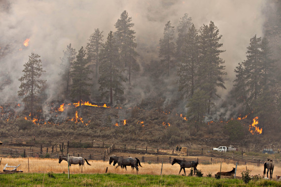
A group of horses pay no attention to a firing operation going on behind them on Division X of the Okanogan Complex August 25, 2015. Firefighters were using drip torches and incendiary devices (sausages) shot from a verry pistol to burn out the hillside to the west of Spring Coulee Road in Okanogan, WA connecting areas to the north and south that had previously burned to protect homes in the area.

Tom Story, who is in Washington documenting some of the wildfire activity, spent time on Monday at the Hopps Helibase near Colville, WA. While in Washington, Tom also spent time with 200 U.S. Army soldiers who were training to assist in the firefighting effort. 

Here is his dispatch from the Hopps Helibase on Aug. 25, 2015.

****

Walker’s Area Command, based in Colville, WA, in August of the 2015 fire season, has setup a large helibase on farmland south of town. The property is owned by the Hopps family, thus giving the base it’s name. The facility allows both civilian contract helicopters a base and a location for military ships to stage until needed on the numerous fires in the area.

At Hopps this morning; August 25th, were a pair of Bell 205 A1++, two AStar A350s, one Bell 206 L4 as well as one of Columbia Helicopters Boeing Vertols joined by a couple of Blackhawks and a Chinook flying in from their overnight base at Fairchild A.F.B outside of Spokane.

The Federal Aviation Administration is operating a temporary tower at the helibase since up to 20 helicopters are anticipated to be using the base as the fire season continues in northeast Washington.

With the FAA control tower in the background and a Bell 205 A1 ++ in the foreground, a Bell 206 L4 carrying members of Swan Valley Helitack from the Caribou-Targhee National Forest, take off for a mission on the Carpenter Road Fire.
Members of Swan Valley Helitack from the Caribou-Targhee National Forest prepare for a mission to the Carpenter Road Fire near Colville, WA August 25, 2015.
An Army Chinook lumbers overhead on final approach for a landing at the Hopps Helibase over a Columbia Helicopters Boeing Vertol.