UPDATED: Smoke map, Aug. 26, 2015

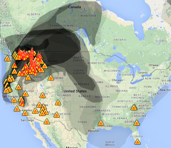
Smoke map, Aug. 26. 2015. Source: wunderground.com

Areas of Washington, Idaho, Oregon and Montana are in the center of the worst smoke being generated by local fires, as of 8:45 a.m. MDT. Air quality forecasts show unhealthy levels of smoke in all four states, with unhealthy advisories extending into Canada.

Air quality advisories, Aug. 26, 2015. AIRNow.gov

As of 8:45 a.m. MDT, there were no Red Flag Warnings. These warnings can change throughout the day as the National Weather Service offices around the country update and revise their forecasts and maps. For the most current data visit this NWS site or this NWS site.

UPDATE:

While there were no Red Flag Warnings issued as of 12:40 p.m. MDT, fire weather forecasts show elevated risk for southeastern Oregon and northeastern California. A second-day forecast showed critical fire weather risk spreading into Idaho and Montana.

Fire Weather Outlook, Day 1, noaa.gov
Fire Weather Outlook, Day 2, noaa.gov

To see the most current smoke reports on Wildfire Today, visit the articles tagged “smoke” at https://wildfiretoday.com/tag/smoke/

The states’ role in wildland fire suppression

Generally it’s the U.S. Forest Service and the other federal land management agencies that receive much of the attention when many wildfires are burning around the country. But a large portion of the credit for suppressing them should go to the fire organizations in the states. On Tuesday the National Association of State Foresters issued the following statement about their role.

****

NASF Wildland Fire Expert Addresses Current Fire Situation

WASHINGTON—As the western United States continues to experience significant wildland fire activity, state forestry agencies are working around-the-clock with their partners in fire suppression. State Foresters—the directors of state forestry agencies—allocate resources, ensure public information and safety, and provide technical expertise and personnel needed to fight fires safely and effectively.

State and local resources are first to respond to approximately 75 percent of all wildland fires in the United States. These agencies provide critical resources and experience to wildland fire management and suppression as part of the coordinated national wildfire response. State forestry agencies also support prevention and mitigation efforts to reduce the threat of fire in the first place.

Bob Harrington, Montana State Forester and chair of the National Association of State Foresters Wildland Fire Committee said today:

“The United States is facing significant fire activity in the Pacific Northwest, Northern Rockies, California, and the Great Basin, and in the Southwest and Southern regions as well. This level of fire activity has not occurred since 2007, and firefighting resources are scarce despite sharing of resources across the country.”

“With evacuations, structures burning and communities and infrastructure at risk, the role of state forestry agencies has never been more critical. Of the more than 32,000 personnel currently assigned to large fires, a significant percentage are employed or mobilized by state forestry agencies.”

“In an average year, states typically deploy an average of $1.6 billion in personnel and resources towards the prevention, control, and management of wildfire.”

“In addition to the state supported response, state foresters work with the USDA Forest Service to deliver the State Fire Assistance and Volunteer Fire Assistance programs, which together provide resources to reduce hazardous fuels and to train and equip first responders. In fiscal year 2014 more than 102,000 firefighters received wildland fire training through these programs. Nearly 11,900 communities were assisted by SFA and VFA during this same time period.”

The National Association of State Foresters is comprised of the directors of state and territorial forestry agencies and the District of Columbia. NASF seeks to advance sustainable forestry, conservation, and protection of forestlands and their associated resources. Learn more at www.stateforesters.org.

Review of “On the Burning Edge”

John N. Maclean’s  review of the book, “On the Burning Edge”, was first printed in the “Journal of Forestry”, a publication of the Society of American Foresters. It is used with permission here.

****

HOTSHOTS, MISSED SHOTS, AND WHERE’S THE FIRE?

On the Burning Edge. Kyle Dickman. 304 p. $26.00 (hardcover). Ballantine Books. 2015. ISBN: 978-0-55339-212-8.

Journal of Forestry 113

By John N. Maclean

Copyright © 2015 Society of American Foresters

A book written quickly in the wake of a major disaster, in this case the Yarnell Hill Fire of 2013, should be a first draft of history, a skeleton on which the reading public can rely, with adjustments as time brings more insight, reflection, and information.

The Yarnell Hill Fire, which cost the lives of 19 members of the Granite Mountain Hotshots, is the worst disaster for an organized wildland fire crew in over a century, back to the Big Burn of 1910. Two years later, many questions remain unanswered: Why did the hotshots leave a safe place and descend into a box canyon where they were overwhelmed by a flame front? Why wasn’t the fire controlled in its early stages? Were supervisory personnel negligent? Why are the two official investigations, both by the state of Arizona, so radically different: one says there were no major mistakes; the other says there were many willful and serious ones.

The fire has been the subject of extensive media and Internet coverage. A massive, unprecedented quantity of audiovisual recordings made during the fire and other data provide a rich trove of factual material to consider.

The first book based on the fire appeared in May 2015: On the Burning Edge, by Kyle Dickman, who wrote about the event earlier for Outside Magazine. Dickman, who was a temporary firefighter with the Tahoe Hotshots for most of the 2006 season, spends the bulk of the book on hotshot culture and the experiences of the Granite Mountain Hotshots well before the Yarnell Hill Fire. He speed-wrote and reported the book on a tight, 16-month publisher’s deadline. “I’d wake up at six and type until 2 AM and find time for a nap and a run in between,” he has noted.

The book reads easily, but shows every sign of an overhasty attempt to capitalize on a human and natural disaster, for which the publisher should accept some responsibility. A marketing blurb claiming that the book is the “definitive” account of the Yarnell Hill Fire has done the author no favor. Even friendly reviewers on Amazon. com balk at that one.

The book contains far too many factual errors, several even corrected in second references. Dickman writes that his main source, Brendan McDonough, the lone surviving hotshot, was a rookie 4 years earlier, then later correctly states he was starting his third year as a hotshot. A short prologue says a middle school is “soon to catch fire,” and a very large air tanker (VLAT) “could unload thirty thousand gallons of fire retardant in a single drop.” Later, Dickman reports flames never touched the middle school and a VLAT can hold just over 11,000 gallons.

Important historical references can be vague: the first hotshot crews “emerged in the 1940s”; his benchmark for previous wildland firefighter deaths was “in the 1930s,” probably a reference to the Griffith Park Fire of 1933 in the city of Los Angeles, which killed 29 members of a road crew impressed into fighting the fire.

And why regularly overdramatize such an inherently dramatic event? A falling tree with only an 18-in. diameter lands with enough force to cause a minor earthquake: “Every hotshot on the line could feel the ground shake.” Alaska fires toss half-ton logs thousands of feet into the air. More significantly, a breathless telling of McDonough’s retreat from a lookout post doesn’t match the evidence or the account of the firefighter who picked him up.

Dickman has been criticized for inventing dialogue and thoughts for the lost crew in his magazine article and again in his book. In recounting a prior fire, for example, one hotshot who did not survive the Yarnell Hill Fire finds time for a quiet moment alone to “fantasize of past lovers” and “create and dispel” fears of losing a girlfriend. Young men do think in these terms, but the scene smacks of make-believe.

When he gets to the Yarnell Hill Fire, Dickman adds little to an understanding of this highly complex event with one potentially significant exception, about a vital radio conversation just before the hotshots left “good black” and headed for the box canyon. McDonough, who survived because he was detached as a lookout, has told his story in different versions to official investigators and others. What he had not done before Dickman’s book came out was to tell his story under oath, for litigation stemming from the fire.

In the book, McDonough exonerates Eric Marsh, Granite Mountain’s superintendent, from a much-rumored charge that he ordered his crew to pack up and leave the “good black” during a heated radio exchange with his No. 2, Jesse Steed. Dickman tells us McDonough, who overheard the relevant conversation, heard no quarrel and no dissenting voice. Whether that account holds up remains to be seen: one hopes it does, for everyone’s sake.

John N. Maclean (john@johnmacleanbooks.com), author of Fire on the Mountain and other books on wildland fire. Maclean is writing a book about the Yarnell Hill Fire.
Okanogan complex largest fire in Washington history

Okanogan Complex
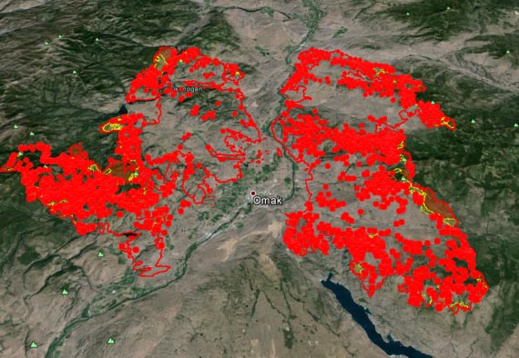
Okanogan Complex. Fire perimeter as of Aug. 24, 2015.

The Okanogan complex fires have grown into the largest wildfire in Washington history at more than 256,567 acres, surpassing last year’s record-setting Carlton complex fires, which burned 256,108 acres.

The complex is now made up of what were five fires — the Twisp River fire, the Lime Belt fire, the Beaver Lake fire, the Blue Lake fire and the Tunk Block fire. The Lime Belt, Beaver Lake and Blue Lake fires have merged, according to the latest perimeter information from the U.S. Forest Service.

The two main branches of the fire — the merged Lime Belt fires and the Tunk Block fire — have burned more than 100,000 acres each.

The latest perimeter maps for the complex, taken from infrared data on Aug. 24, do not include the Twisp fire.

As of Aug. 24, more than 500 utility customers remain without power in Okanogan County, since the fire complex has destroyed more than 500 utility poles, according to the Okanogan County Public Utility District. It will take a week to restore power to some areas, while it could take a few weeks to restore power to others.

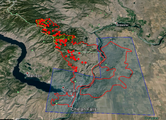
The Chelan complex fires (see below) also continued to rage south of the Okanogan complex. Infrared flights on Aug. 24 showed that the fire had grown 509 acres, expanding the fire perimeter to 87,830 acres.

Overall, the fire’s heat has dropped, particularly in the perimeter’s southern and eastern quadrants (highlighted blue area on the map). These quadrants were not scanned by IR flights on Aug. 24, since there has been little heat in those areas for several nights, according to flight information.

Chelan Complex fire perimeter as of Aug. 24, 2015.
Chelan complex fire perimeter as of Aug. 24, 2015.

Smoke Map and Red Flag Warnings, Aug. 25, 2015

Map of smoke from wildfires, morning of Aug. 25, 2015.
Map of smoke from wildfires, morning of Aug. 25, 2015, AIRNow,gov

Areas of Oregon, Washington, Idaho, Montana have “unhealthy” air quality advisories, due to wildfire smoke. AIRNow.gov forecasts show that areas along the Idaho, Washington and Oregon border are expected to reach the “very unhealthy” level on Tuesday.

As of 8 a.m. MDT, Washington is the only state with Red Flag Warnings. These warnings can change throughout the day as the National Weather Service offices around the country update and revise their forecasts and maps. For the most current data visit this NWS site or this NWS site.

Air quality affected by wildfire smoke. AIRNow.gov

To see the most current smoke reports on Wildfire Today, visit the articles tagged “smoke” at https://wildfiretoday.com/tag/smoke/

Over 32,000 personnel committed to wildfires in the western U.S.

Okanogan Complex of Fires
Structure protection on the Okanogan Complex of Fires, August 21, 2015. InciWeb photo.

Western wildfires by the numbers:

49 — Incident Management Teams assigned.
3 — Area Command Teams assigned.
79 — Uncontained large fires. Some are “complexes” comprised of numerous fires.
232 — Large fires.
6 — Military C-130s (MAFFS) activated with slip-in retardant tanks.
671 — Hand Crews assigned.
1,885 — Fire engines working on fires.
217 — Helicopters on fires.
32,318 — Personnel committed to fires.
34 (at least) — Large air tankers and scoopers from the U.S. working on fires. Dozens of smaller single-engine air tankers are also working.
4 (at least) — Large air tankers and scoopers borrowed from Canada.

fires Washington, Northern Oregon, northern Idaho,
Heat detected by a satellite, in Washington, Northern Oregon, northern Idaho, and western Montana in the 24 hours before 7:45 p.m. PT August 24, 2015. (click to enlarge)