(Originally published at 7:30 a.m. PDT July 20, 2017)
(Updated at 7 p.m. PDT July 20, 2017)
CAL FIRE reported Thursday that the Detwiler Fire has destroyed 50 single family residences.
In the photo below Air Tanker 912, a DC-10, makes a retardant drop on the Detwiler Fire.
Fire crews continue to battle the #DetwilerFire near the town of Coulterville, Calif., on Thursday, July 20, 2017. pic.twitter.com/HOOI19hIXu
— Andrew Kuhn (@ARKuhn) July 21, 2017
(Updated at 5:02 p.m. PDT July 20, 2017)
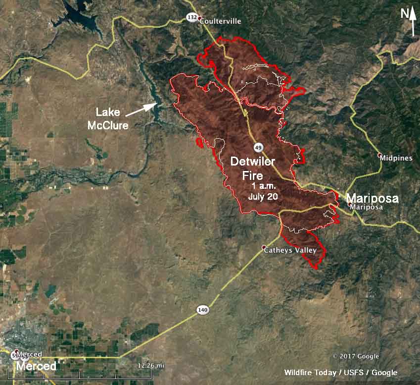
Above: A 3-D map of the Detwiler Fire looking south from Coulterville, CA. The red shaded area was the perimeter at 1 a.m. July 20.
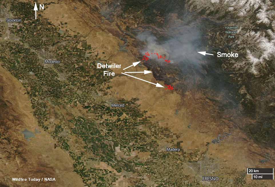
The Detwiler Fire was very active again Wednesday for the fourth day since it started and moved to within 2 miles of Coulterville, California. It grew by 4 miles on the north side, 3 miles on the south side, and 2 miles on the east. There was much less movement on the west side.
At 1 p.m. on Thursday the fire had spread north beyond the fire perimeter that was mapped at 1 a.m. and was less than 2 miles from Coulterville. It had crossed Crown Lead Road, which is south of Coulterville. The incident management team has a great many firefighting resources making preparations south of the town, including helicopters, hand crews, fire engines, and dozers. Firelines are being built and it is likely that when they are complete air tankers will reinforce those lines. The fire was also active at 1 p.m. Thursday on the northeast side as well as southeast of Catheys Valley on the south side.

Southeast of Coulterville the fire is less than a mile from the boundary of the Stanislaus National Forest. A CAL FIRE incident management team has been running the fire but an Interagency Type 1 Incident Management Team has been ordered to report to the fairgrounds at Sonora 22 air miles north of the fire. The assumption probably is that the fire will be in the National Forest in a day or two.
By Thursday morning at 1 a.m. the fire had burned 73,096 acres, an increase of 27,372 acres since the previous mapping flight at 10 p.m. on July 18. (There is some confusion about the acres burned, with some sources reporting the total is 70,096.)
CAL FIRE reports that 45 structures have been destroyed. It is not clear if that number includes outbuildings.
The map of the Detwiler Fire was current at 1 a.m. PDT July 20, 2017

Highways 49 and 140 are both closed in the fire area. CAL FIRE and the Mariposa County Sheriff’s Office have more information about evacuations, although CAL FIRE’s information site about this rapidly spreading fire is updated infrequently.


The USFS Blue Sky Modeling Framework projects where smoke is expected from the #DetwilerFire , impacting the Sierra & foothills. #cawx pic.twitter.com/sZjwTFDF4Y
— NWS Sacramento (@NWSSacramento) July 20, 2017
(All articles on Wildfire Today about the Detwiler Fire are tagged “Detwiler Fire” and can be found here, with the most recent at the top.)


Does anyone know if Catheys Valley / Hornitos rd was burned, my mom lives in Whispering oaks off hornitos rd and I cant get in touch or find out any info on that area. Please advise very worried…. off 140 going east turn right on hornitos rd a few miles down she is on the right side in whispering oaks a housing development. thank you
What about Bear Valley?
Bill, thanks for your prompt response. I tried the link you provided and it took me back to the information on the 19th.
I tried to refresh and got the info on the 20th.
I found your coverage to be the most accurate and timely so hopefully you can understand my interest in getting your updates.
Sorry for the confusion; I fixed the link. Here it is again:
https://wildfiretoday.com/tag/detwiler-fire/
Bill, thanks that one works. How often should I expect updates? The maps in particular are important to show the growth.
I am recommended to everyone I talk to.
I meant to write I recommend your post to everyone I talk to!
Are there any updates, the narrative and maps are dated.
All articles on Wildfire Today about the Detwiler Fire are tagged “Detwiler Fire” and can be found here, with the most recent at the top.
Honestly if you want the full amazing experience I’d wait till the smoke is cleared or your family will just suffer from choking on smoke
My husband and son are scheduled to be camping and hiking for a week in Yosemite National Park beginning tomorrow, July 22. Would you advise that they avoid the park for a few days? I’ve looked at the nps.gov webcams, and the park looks extremely smoky. Thanks for any advice from the ground there!
Are there any updates on if the fire has reached Coulterville yet?
The fire is near Coulterville but there are numerous fire trucks and fire support lined up along the streets. Sounds like there is a lot of activity there today to protect the town. We have had to pass through there to evacuate our horses but now I believe it is closed to through traffic.
My son is up
There near groveland any news
The town of Groveland is at the moment fine. No evacuations there yet. I live near Buck Meadows, about 11 East of Groveland.
Thank you I have a daughter and son up
There
Is anyone near jackass creek access road?? Any news please update me I’d appreciate it so much
I just came back that way today it’s smokey but fire still a ways away
So far nothing is coming that way
Everyone on the north side of Greeley hill road is in advisory at this point.
Please update me on Greeley hill my grandparents whole life is right there
I am off Dexter Rd, on Pine Drive in Greeley Hill. The air quality is good and was all night. The fight seems to be down near Coulterville right now. We can not return home if we leave and I have a number of cats and dogs, horses have already been moved. There is no mail or delivery service. Many people in this area have left home already. It is pretty quiet up here. Sounds like the Pros from Dover and all over are here , now. Hopefully, they will not throw us away. We are all still working hard on getting the ten million dead trees down . Looks like a long fight.
Being from Mariposa your reporting is the most accurate and timely of ANY media service! And I have look at them all.
I am currently in Greeley Hill, about 7 miles east of Coulterville and under the evacuation umbrella. Smoke isn’t bad this morning, not like yesterday thankfully.
I’ll be posting videos from the ridge above Greeley on Facebook. FB: American Mining Rights
Thanks and keep reporting for us. AMRA member.
We’re holding firm on Greeley Hill Road. I’ll look for your videos and they might help us decide. Should we stay or should we go?
We are in Twain Harte, the smoke is intermittent and my porch is covered in ash, our thoughts and prayers for everyone’s safety are with you!