Above: Detwiler Fire photo courtesy of Sacramento Fire Department
(Originally published at 7:58 a.m. PDT July 21, 2017)
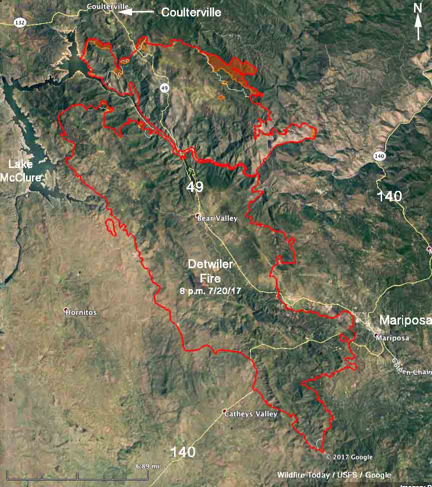
Firefighters working to keep the Detwiler fire out of Mariposa and Coulterville Thursday were grateful for the moderate weather that resulted in less spread of the fire than in previous days. The south end has not seen much growth for a couple of days but the north side continues to get closer to the community of Coulterville in the central California foothills of the Sierras. The fire is less than two miles from the town but the incident management team has large numbers of resources in the area constructing firelines and prepping structures.
The map of the Detwiler fire below was current at 8 p.m. July 20, 2017.

The wind on Thursday recorded at a weather station in Mariposa, was primarily from the west and north at six mph. If it was similar at Coulterville it would have slowed the growth of the fire toward the community, buying firefighters more time to put in defenses.
The weather forecast in the Coulterville area for Friday is not as favorable, with southwest winds of 10 to 13 mph gusting at 15 to 20, then switching to come out of the northwest late in the afternoon at 8 mph. The temperature should be in the mid-90s with the relative humidity in the high teens.
CAL FIRE is calling the fire 74,083 acres, but the map they distributed Friday morning along with that acreage figure (below) has a fire perimeter that was current at 1 a.m. on July 20 and does not show the most recent fire growth near Coulterville and on the east side of the fire.
#DetwilerFire [update] QUICK update. @CALFIRE_PIO @CAL_FIRE @R5_Fire_News @YosemiteFire pic.twitter.com/Q2pPIbMSop
— CAL FIRE MMU (@CALFIREMMU) July 21, 2017
CAL FIRE reports that 58 residences have been destroyed.
Highways 49 and 140 are both closed in the fire area. CAL FIRE and the Mariposa County Sheriff’s Office have more information about evacuations, however CAL FIRE’s information site is updated infrequently.
Most of the large air tankers are reloading with retardant at Castle Airport, which is 25 miles west of the fire. On Wednesday the vendor at the base ran out of fuel, so air tankers needing more had to divert to Mather Airport southeast of Sacramento to get fuel, and then fly to Castle for retardant. A CAL FIRE spokesperson said that by Thursday the fuel shortage had been resolved.
Fire officials are establishing a retardant site for helicopters so that they can drop long term retardant on the fire rather than water, which is less effective.
The Detwiler Fire still has not spread into the Stanislaus National Forest. Southeast of Coulterville it is about half a mile away from the Forest boundary.
(All articles on Wildfire Today about the Detwiler Fire are tagged “Detwiler Fire” and can be found here, with the most recent at the top.)


I have family that work at B & B and have not heard any damages done.
Any news on Buckeye Creek Road? My friends have a B and B there- the Restful Nest. If anyone has any info. About the B & B or Jon Pierre and Lois Moroni (the owners), please contact Jody Snyder at Pennygwynne@Yahoo.com
We have 5 acres in bootjack. Thank God it didn’t make it that far. Prayers for those who lost their homes. Hope the wild animals are ok. Hope they can gain control of the fire soon.