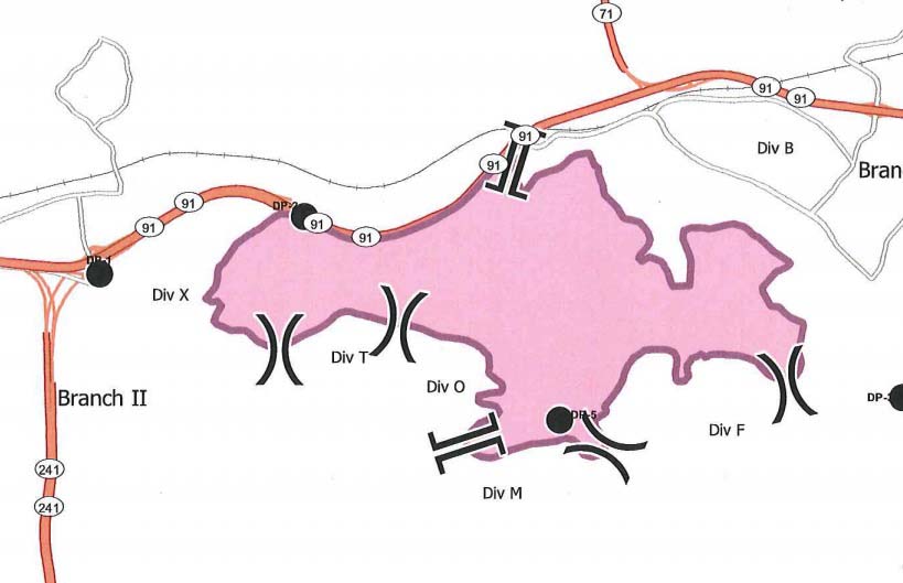
Above: Map of the Canyon Fire at 7:50 p.m. PDT September 26, 2017.
(Updated at 8:37 a.m. PDT September 27, 2017)
Firefighters have had some success battling the Canyon Fire just southwest of Corona, California. On Tuesday it spread very little, however still remaining unburned islands of vegetation within the perimeter continued to put up smoke.
According to the Wednesday morning official update from the Incident Management Team evacuation orders are still in effect for all areas south of Green River Road from State Route 91 to W. Foothill Parkway, including the Skyline Drive Area. Eight schools in the area will continue to be closed on Wednesday, September 27.

The updated perimeter map shows that the fire burned well into housing developments on the west side of Corona but the incident management team reports that three structures were damaged but no homes were destroyed. This is a result of several things: outstanding efforts by firefighters who battled the flames and ember showers, the residents who prepared their properties well in advance to be more fire resistant, and the work by local agencies to educate citizens about how to live in a fire-prone environment.
Streets that were heavily impacted by the fire include San Viscaya Circle, San Ponte Road, San Ramon Drive, Oakridge Drive, Elderberry Circle, Goldenbush Drive, Bulrush Circle, Sageleaf Circle, Canyon Crest Drive, Wilderness Drive, and Hidden Hills Way.
Resources assigned to the fire include 272 engines, 10 water tenders, 11 helicopters, 10 dozers, and 30 hand crews for a total of 1,652 personnel. Two of the helicopters, from Orange County and the U.S. Forest Service, are capable of making water drops at night,
Our unofficial estimate shows that the fire has burned approximately 2,650 acres, but Wednesday morning the Incident Management Team is sticking with their 2,000-acre figure they have been using for several days.
Below are some of the best images and videos posted over the last couple of days about the fire on Twitter and Instagram.
The #CanyonFire prompted the evacuation of some 1,500 people from around 500 Riverside County homes. https://t.co/YqGuQjzCgZ pic.twitter.com/Izx6FEjh0L
— NBC Los Angeles (@NBCLA) September 27, 2017
Interesting wind direction change on the first day of the #CanyonFire near Corona, CA https://t.co/B7eZaHrLSv
— Wildfire Today (@wildfiretoday) September 27, 2017
Cannot stress this enough: stay off the 91E if you can help it. #CanyonFire is burning very close to freeway, cars. pic.twitter.com/LfaIPZlQx8
— Greg Lee (@abc7greg) September 26, 2017
Corona was crazy scary yesterday! #CanyonFire pic.twitter.com/nnZ4TyycCC
— Jennifer Chavez (@inlove247) September 27, 2017
2,000 acre #CanyonFire containment at 15%, 1,652 firefighters. Unified Command CAL FIRE, USFS, OCFA City of Anaheim https://t.co/ltkzRtqUBV pic.twitter.com/fIAG58atx1
— YubaNet Fire News (@YubaNetFire) September 27, 2017
People have said Very Large Air Tankers, such as the DC-10 seen above and below, can only be used in flat or gently rolling terrain.


Any current reports on Corona fire in Corona, CA.? See nothing on internet since Thursday, September 26th.