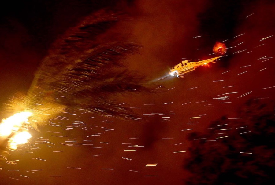
“They were heroes — highly skilled professionals”

(Originally published at 7:35 p.m. MDT September 27, 2017)

Today I was looking back at what I wrote at 6:15 p.m. MDT June 30, 2013, the day 19 firefighters were killed in the line of duty on the Yarnell Hill Fire south of Prescott, Arizona. What initially got my interest was the fact that a fire that had been burning for only about 48 hours had ordered a Type 1 Incident Management Team — a little unusual, but not unheard of, for a young fire.

That evening I found some intermittent live video from ABC15, a photo posted on Twitter by Jeffrey Blackburn (@lensjb) showing very active fire behavior, and a post by @wildfirediva saying three large air tankers and two Very Large Air Tankers were working the fire.

But the one that really got my attention was this:

Below are portions of a statement released by President Obama the next day:

…They were heroes — highly-skilled professionals who, like so many across our country do every day, selflessly put themselves in harm’s way to protect the lives and property of fellow citizens they would never meet. … But today, Michelle and I join all Americans in sending our thoughts and prayers to the families of these brave firefighters and all whose lives have been upended by this terrible tragedy.
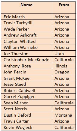
Yarnell Hill Fire firefighters killed
The 19 firefighters from the Granite Mountain Hotshots that were killed on the Yarnell Hill Fire.

I continued to update the story on a near-real-time basis for the next five days.

Now as October 20 grows closer I have been thinking more frequently about what happened 1573 days before that date.

On October 20 a movie “based on the true story of the Granite Mountain Hotshots” will be widely released — Only the Brave. Many firefighters, former firefighters, and those closely associated with those 19 individuals are apprehensive about this, perhaps for a variety of reasons. How will the producers, writers, actors, and the director treat this event that that still deeply touches a large number of people? Can a for-profit company make a commercial movie about a very sensitive fatal incident that does not take advantage of deep-seated feelings and in some instances mild or serious cases of posttraumatic stress disorder?

Only the Brave movie

The film is not a documentary, so it is a given that it will take liberties with the actual facts. It has to tell a story, and most movie treatments have a conflict that eventually is resolved — or not. What will that conflict be in this adaptation of the story?

Many of the outdoor scenes were shot in northern New Mexico in the Santa Fe area where the fuels and terrain are very different from the fatality site on the Yarnell Hill Fire south of Prescott, Arizona.

And, the objective of the makers of the project, Black Label Media, Columbia Pictures, and Sony, is to make money.

These issues do not mean it can’t be a great film after which most moviegoers will leave feeling uplifted, or at least satisfied that the events and the real people involved, many still alive today, were treated fairly and honestly.

This project is not unprecedented. There have probably been hundreds of movies made based on real events in which dozens or hundreds of people died. Some were great, and others were not.

Little real information about the movie has been disclosed. There have been a couple of trailers, mostly based on action scenes. I have not seen anything about the story behind the action, or what drives the characters.

There have been a few quotes from actors and a producer that have been encouraging. The word “hero” has been used in describing the Hotshots. Here’s the official description of the film:

It’s not what stands in front of you… it’s who stands beside you. Only the Brave, based on the true story of the Granite Mountain Hotshots, is the heroic story of one unit of local firefighters that through hope, determination, sacrifice, and the drive to protect families, communities, and our country become one of the most elite firefighting teams in the nation.  As most of us run from danger, they run toward it – they watch over our lives, our homes, everything we hold dear, as they forge a unique brotherhood that comes into focus with one fateful fire.

Molly Smith, an executive with Black Label Media, said it’s the film she’s most proud of:

We hope you feel, when you see it, as patriotic and proud as we have to have some of the greatest firefighters in the world constantly putting themselves out there for our well being. The ones who have lost their lives we honor respectfully every day, and the ones who wake up covered with dirt and ash and stale coffee on their breath (and always a ribbing laughter) we salute you again and again and again. I hope you feel we have represented you well.

A few weeks ago in an Entertainment Weekly interview, Josh Brolin (Eric Marsh, Crew Superintendent in the film) who for a while was a volunteer firefighter in Arizona, talked about how the actors in the movie still maintain regular contact even after the filming ended a year ago:

This was different, probably because of the subject matter. Nobody’s willing to let it go.

The film has the potential to have some realistic elements. At least one former Granite Mountain Hotshot provided advice as it was being made. The firefighter-actors participated in a multi-day fire boot camp before filming began. The pictures I have seen show the actors wearing typical wildland firefighting gear, and Granite Mountain Hotshot’s actual crew buggies were used.

A new foundation has been created apparently by the film’s producers, called the Granite Mountain Fund, described as a “philanthropic initiative of ONLY THE BRAVE”. The website promises that 98.5 percent of the donated funds will go to one of six organizations, including the Wildland Firefighter Foundation, the Eric Marsh Foundation, and Prescott Firefighter’s Charities.

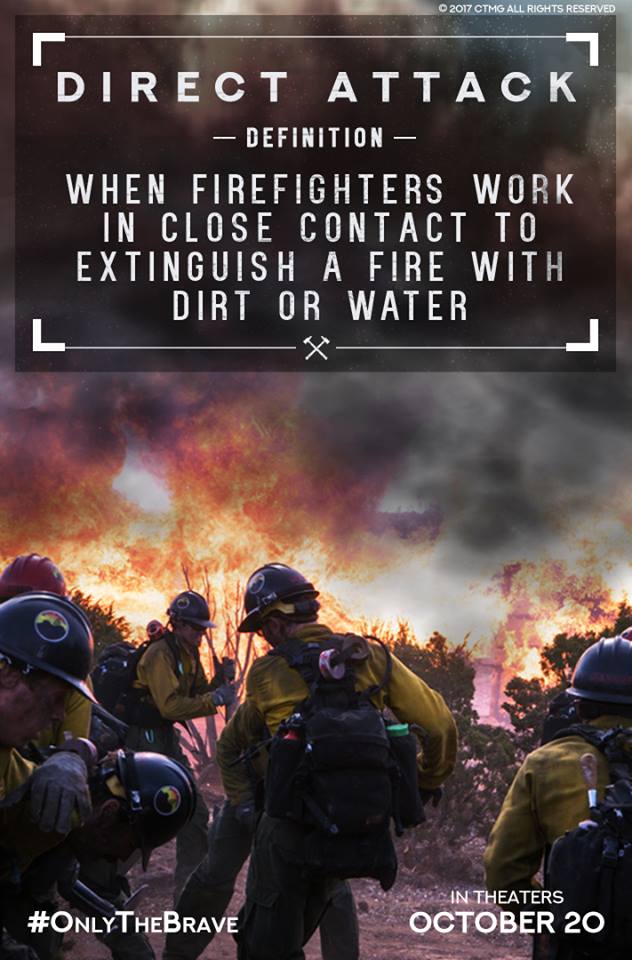
Granite Mountain Fund

Updated map of the Canyon Fire near Corona, California

Our unofficial estimate shows that the fire has burned approximately 2,650 acres.

Above: Map of the Canyon Fire at 7:50 p.m. PDT September 26, 2017.

(Updated at 8:37 a.m. PDT September 27, 2017)

Firefighters have had some success battling the Canyon Fire just southwest of Corona, California. On Tuesday it spread very little, however still remaining unburned islands of vegetation within the perimeter continued to put up smoke.

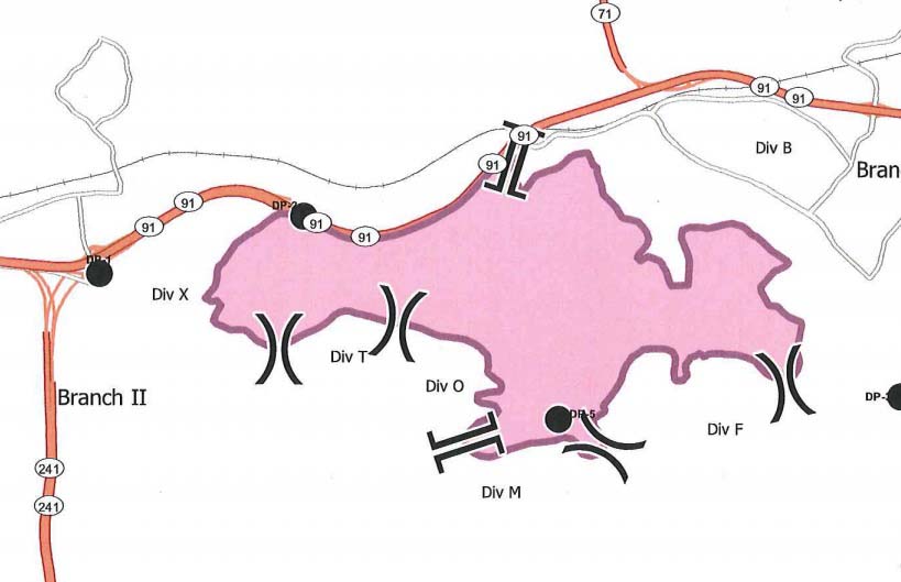
According to the Wednesday morning official update from the Incident Management Team evacuation orders are still in effect for all areas south of Green River Road from State Route 91 to W. Foothill Parkway, including the Skyline Drive Area. Eight schools in the area will continue to be closed on Wednesday, September 27.

Canyon Fire ma
Canyon Fire map, by the Incident Management Team September 27, 2017.

The updated perimeter map shows that the fire burned well into housing developments on the west side of Corona but the incident management team reports that three structures were damaged but no homes were destroyed. This is a result of several things: outstanding efforts by firefighters who battled the flames and ember showers, the residents who prepared their properties well in advance to be more fire resistant, and the work by local agencies to educate citizens about how to live in a fire-prone environment.

Streets that were heavily impacted by the fire include San Viscaya Circle, San Ponte Road, San Ramon Drive, Oakridge Drive, Elderberry Circle, Goldenbush Drive, Bulrush Circle, Sageleaf Circle, Canyon Crest Drive, Wilderness Drive, and Hidden Hills Way.

Resources assigned to the fire include 272 engines, 10 water tenders, 11 helicopters, 10 dozers, and 30 hand crews for a total of 1,652 personnel. Two of the helicopters, from Orange County and the U.S. Forest Service, are capable of making water drops at night,

Our unofficial estimate shows that the fire has burned approximately 2,650 acres, but Wednesday morning the Incident Management Team is sticking with their 2,000-acre figure they have been using for several days.

Below are some of the best images and videos posted over the last couple of days about the fire on Twitter and Instagram.

Continue reading “Updated map of the Canyon Fire near Corona, California”

Park Service boat hauls supplies to hurricane ravaged islands

Above: MV Fort Jefferson. NPS photo.

A lot of people have not heard of a park that is 68 miles west of Key West, Florida. Dry Tortugas National Park is comprised of seven islands, plus protected coral reefs. Garden Key is home to beaches and the 19th-century Fort Jefferson. The National Park Service operates a boat named after the fort that makes regular runs to the park. It turns out that a boat is one of the best ways to haul large quantities of supplies to hurricane damaged islands.

From the National Park Service on September 25, 2017:

****

Homestead, Fla. – The 110-foot MV [Motor Vessel] Fort Jefferson, normally used to transport staff and supplies to Dry Tortugas National Park, has been loaded with over 24 tons of supplies and equipment for national parks in the Caribbean following Hurricanes Irma and Maria. The vessel departed today and will make the 78-hour trip from Key West to the Caribbean national parks this week.

“We are grateful to Dry Tortugas National Park for use of their vessel to get critical supplies to our Caribbean parks,” said [Eastern Incident Management Team] Incident Commander James King. “When I contacted Park Superintendent Pedro Ramos, he didn’t bat an eye and immediately offered his support.”

On Sunday, September 24, EIMT logistics personnel loaded over 20 pallets of food, water, fuel, and generators on the vessel. Three National Park Service boat crewmembers along with four Law Enforcement Rangers will accompany the shipment to the Caribbean. The boat is transporting supplies and resources to Virgin Islands National Park on the island of St. John and Christiansted National Historic Site on the island of St. Croix.

MV Fort Jefferson
NPS photo.

In addition to transporting supplies for the National Park Service, the vessel is also transporting six pallets of supplies for the U.S. Fish and Wildlife Service, a sister agency within the Department of the Interior. The agency has employees on the Caribbean Islands, who normally work at three National Wildlife Refuges. The two agencies have worked closely through Hurricanes Irma and Maria on stabilization, cleanup, and recovery efforts.

Employee accountability and care continue to be primary concerns of the National Park Service. Employees at all six national parks in the Caribbean have been accounted for, with the exception of San Juan National Historic Site where employee communications are currently hampered by power outages, flooding, and inaccessible roadways.

Additional updates on the status of these parks can be found at http://go.nps.gov/hurricane. Photos may be found at www.flickr.com/photos/nps_eimt.

Canyon Fire burns thousands of acres near Corona, California

(Originally published at 8:22 a.m PDT September 2, 2017)

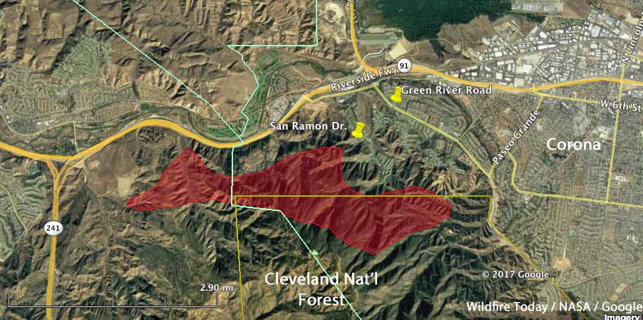
map Canyon Fire
Map showing the approximate location of the Canyon Fire at 1:18 a.m. PDT September 26, based on heat detected by a satellite. Click to enlarge.

The Canyon Fire that started Monday afternoon south of Highway 91 in Orange County, California remained active overnight on the slopes above Corona after spreading into Riverside County. Evacuations are still in effect for areas on the southwest side of the city.

Three night-flying helicopters worked the fire Monday night, dropping water to assist firefighters on the ground. At least eight air tankers will be available on the fire Tuesday, including a DC-10 Very Large Air Tanker.

The fire is burning on the northern end of the Cleveland National Forest near the North Main Divide and has reached Sierra Peak, the home of many communication towers and facilities. Firefighters in that area are reporting long-range spotting, even before 8 a.m.

The last size reported by fire personnel was 2,000 acres.

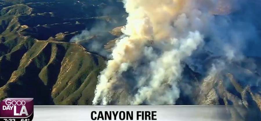
canyon Fire
Canyon Fire. Screengrab from Fox LA television at 7:32 a.m. PDT September 26, 2017.

The wind slowed Monday night and the relative humidity increased in the valleys below the fire, but at 7:30 a.m. the fire was putting up a large column of smoke southwest of Corona. During the night the humidity remained in the teens at several weather stations in the hills above the valleys at the same elevation as the main portion of the fire. This could account for the very active fire behavior early Tuesday morning even with very little wind.

The weather forecast is not in favor of the firefighters. The wind on Tuesday is expected to increase to 10-16 mph with gusts above 20 mph, while the temperature will be in the high 80s with the relative humidity in the high teens. The wind will be generally from the east until noon, when it should switch to come out of the west and southwest. Wind shifts like this are dangerous for firefighters.

For the latest articles on Wildfire Today about the Canyon Fire go to https://wildfiretoday.com/tag/canyon-fire/

Canyon Fire causes evacuations near Corona, California

Above: The red squares on the map represent heat detected on the Canyon Fire by a satellite at 1:52 p.m. not long after it started September 25, 2017. The arrows directly east of the red squares show the approximate spread of the fire over the next seven hours.

(Updated at 11:58 p.m. PDT September 26, 2017)

The Canyon Fire was reported around 1 p.m. PDT on Monday in southern California near Coal Canyon Road south of Highway 91. It was initially pushed to the southwest by a northeast wind. With single-digit relative humidities it spread rapidly, but by 4 p.m. the wind direction changed and began coming from the opposite direction, the southwest, at 12 to 15 mph which caused the fire to spread east more than two miles over the next five hours, approaching the outskirts of Corona.

Click HERE for the latest articles about the Canyon Fire on Wildfire Today.

By 6:15 p.m. PDT Monday evacuations had been ordered for all homes in Corona south of Green River Road from the 91 Freeway to Trudy Way, including the Orchard Glen Tract.

At about 9 p.m. the Corona Fire Department estimated the fire had burned approximately 2,000 acres.

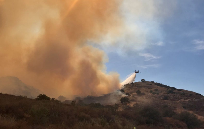
Canyon Fire helicopter drop
A Type 1 helicopter drops on the Canyon Fire, September 25, 2017. Photo by Anaheim Fire & Rescue.

One of the first heavily populated areas hit by the Canyon Fire were the structures on the west side of Corona on San Ramon Drive and San Alvarado Circle where fire engines from Anaheim and other fire departments battled ember showers for hours, protecting the residences. At times night-flying helicopters supported them with water drops. EPN564 broadcast live several times on Periscope; some of his “scopes” may still be available to view.

Canyon Fire Los Angeles County FD Firehawk helicopter drops water
Los Angeles County FD Firehawk helicopter drops water to assist firefighters on the Canyon Fire, September 25, 2017. Photo by @luissinco via @LACoFireAirOps.

The Canyon Fire appeared to start in Orange County then moved into Riverside County and later the city of Corona. There was a report that the communications sites on Sierra Peak in the Cleveland National Forest were seriously threatened. (see map)

The Orange County Fire Authority reported at 11:30 p.m. Monday that one home had been damaged. In addition, the cargo in a trailer pulled by a semi truck caught fire while traveling on Highway 91. The driver pulled over and disconnected the burning trailer from the tractor.

The Corona Fire Department reported that the helicopter water drops would continue Monday night into early Tuesday morning.
Continue reading “Canyon Fire causes evacuations near Corona, California”