(Originally published at 7:04 a.m. PDT July 30, 2018)
The Ranch and River Fires that comprise the Mendocino Complex of Fires were very active again Sunday.
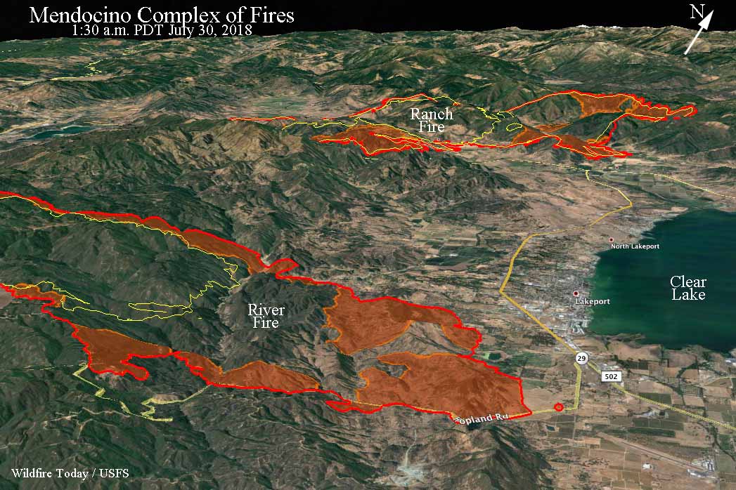
The northernmost of the two fires, the Ranch Fire, spread three to five miles to the east and south and at 1:30 a.m. Monday was less than a mile north of Upper lake. So far firefighters have been able to keep it mostly north and east of Highway 20, but at 1:30 a.m. there was a spot fire across the highway three miles west of Upper Lake.

Farther south, the River Fire grew three miles to the east and at 1:30 a.m. Monday was less than a mile west of the Highway 29/175 intersection near Lakeport. Firefighters are no doubt working hard to keep the fire north of Highway 175, but it had slopped over at one point two air miles southwest of the intersection.
(To see all of the articles on Wildfire Today about the Mendocino Complex of Fire, click HERE.)
Using infrared mapping data our very unofficial estimate of the total number of acres burned in the two fires at 1:30 a.m. PDT on Monday is approximately 55,000. (UPDATE at 7:16 a.m. PDT July 30, 2018: at 7:15 a.m. CAL FIRE updated the size of the fires. They reported the Ranch Fire has burned 35,076 acres, and the River Fire, 20,911, for a total of 55,987 acres.)
CAL FIRE reports that six residences have been destroyed and 10,200 are threatened. The agency also said weather conditions will continue to challenge firefighters as hot, dry and windy conditions persist. A lack of available suppression and overhead personnel will also slow the firefighting efforts, they said.
Mandatory evacuation orders affecting thousands of residents are in place for several locations around the two fires in Lake County. Below is an excerpt from an article in the Lake County News:
The River fire’s approach to the Lakeport, the county seat, and its full evacuation has had numerous impacts, including closure of the Lake County Superior Court, and county and city offices; the evacuation of Sutter Lakeside Hospital and Evergreen Lakeport Healthcare; temporary shuttering of the Lakeport Senior Center; as well as closure of numerous businesses.
The weather forecast for the foothills west of Lakeport for Monday predicts 94 degrees, 18 percent relative humidity, and west or northwest winds of 3 to 9 mph gusting to 13. These conditions are expected to persist through Friday.
Resources assigned to the Complex include 118 fire engines, 22 water tenders, 6 helicopters, 31 hand crews, and 37 dozers for a total of 1,379 personnel.

If you or your family is affected by any of the current wildfires please, please be smart and be safe out there! This is view of the #RiverFire across from Clear Lake in Lucerne part of the two-fire #MendocinoComplex in Lake County (Photo Credit @RonKeas) pic.twitter.com/f6gylmQ8J9
— CalSFS (@CalSFSsocial) July 30, 2018
Pyro cumulus and lenticular clouds as observed by NWS Imet from the #MendocinoComplex fire. #cawx pic.twitter.com/O8sTtPQaWy
— NWS Sacramento (@NWSSacramento) July 30, 2018

Thank you for the updated maps and description of events related to the Ranch and River Fires. Your work is appreciated!