
Red Flag Warnings are in effect in portions of eight states
Continue readingFire information on InciWeb is now subject to being deleted after it is no longer current
We learned recently that agency personnel who post information on the InciWeb website are being told to delete media files, especially videos, when they are no longer current, and to remove all information about an incident when it is no longer active. Wildland firefighting agencies use the website to post current information about ongoing wildfires and other incidents.
There are two reasons for deleting the information according to Jennifer Jones, a Public Affairs Specialist for the Forest Service at the National Interagency Fire Center. The files need to be removed in order to free up storage space. And, in the new version of InciWeb introduced in March, 2018, there can be a clutter of icons on the map representing fires, making it difficult for the public to find the fire they are interested in.
“With the launch of the redesigned InciWeb public site”, Ms. Jones explained, “it has become an issue. Having inactive incidents still showing clutters the map and makes it hard for members of the public to find information about current active fires. In addition, since the capability to add video to InciWeb was added a few years ago, storage space for those files which can be fairly large has also become an issue.”
Ms. Jones said this policy of deleting incidents that are no longer active has always been the policy. But I have found that before the recent major change, I could use Google to search just the InciWeb site to find complete records of fires that occurred years earlier. The new version wiped out, as far as I can tell by using Google, public access to all of the fire information before March, 2018. And now that the delete-media-and-inactive-fires policy is being implemented or enforced, this important data could disappear in a matter of days after being posted.
In the last few years the prices for storage space for digital data have plummeted, so it seems odd that this can be a limiting factor on what information is provided to the public about ongoing emergencies. We should be striving for serving the public with transparency rather than purging important historic information about wildland fire events that affect millions of people.
The problem of the clutter of icons that represent fires on the interactive map on the new version of InciWeb could be mitigated by restoring the user-sortable table that worked very well in the previous version of the website.
We asked Ms. Jones about retention of the data at InciWeb. “Since its inception, the purpose of InciWeb has been to provide a ‘one stop shopping’ source of information about current wildfires” she said. “InciWeb was never set up as an official system of record and was never intended to be used for historic information or reference purposes and it has never been funded or staffed to serve those purposes.”
Before a fire completely demobilizes, the Documentation Unit Leader at the incident command post is supposed to assemble all pertinent data according to very strict guidelines established by the National Wildfire Coordinating Group. It can be a daunting task. The result can look like the two examples below, which are from a training program for incident personnel.

When InciWeb is operating properly it can be a very user-friendly environment for viewing information about an incident. Anyone with internet access can go to the site 24 hours a day, seven days a week, and with a few clicks find troves of information within minutes. This can be invaluable for citizens concerned about nearby wildfires, those learning about their environment, as well as reporters, scientists, and authors, both during and after a fire.

Now that complete records of fires on InciWeb are going to be purged after the fire is no longer active, try to picture how these people will obtain information from the official records shown in the two photos above.
It simply will be far, far more difficult than going to an internet site and finding the data in a minute or two. They could submit a Freedom of Information Act request. We have filed a few of those with the U.S. Forest Service. In one example, even after filing a FOIA, the agency refused to give us a copy of an air tanker study completed under contract by the Rand Corporation. In another case it took the USFS eight months to send us a copy of an existing non-controversial Excel file that we requested.

Dozer operator killed in vehicle accident in California
He was driving to the North Fire on I-80
Continue readingIdaho inmate accused of rape at a fire in Utah
The Idaho Department of Corrections has returned their fire crews to prison while it reviews the program
Continue readingIntroduction to the Benchmark fire lookout in Colorado

Above: Richard Freimuth and his wife staff the Benchmark fire lookout in southwest Colorado. Screen grab from the video.
The SWC Wildfire Coalition posted this video to You Tube featuring Richard Freimuth and his wife who staff the Benchmark fire lookout on the San Juan National Forest in southwest Colorado.
The description posted with the video:
Even in today’s high tech world, humans are still the best when it comes to detecting fires. A bygone, iconic fire watchtower and lookout still have relevance in today’s infrared satellite world.
https://www.facebook.com/SanJuanNF/
Major changes made to InciWeb this year
(Originally published at 3:44 MDT September 11, 2018)
The website where firefighting agencies can post current information about ongoing wildfires and other incidents went through a major change in March. InciWeb, a nickname for Incident Information System, was created in 2004 to provide for the public a single source of incident-related information. When measured by the number of visitors, it has been a huge success. Before it existed it was difficult for the public to ferret out current information about fires that may be threatening their property. Incident management teams would create websites from scratch for fire information, staple paper copies of updates along a “trap line” of bulletin boards in communities near the fire, place the information on social media platforms, or just send news releases to their regular mailing list.
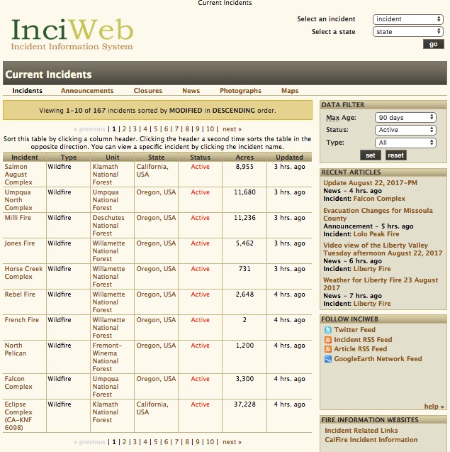
In the last 15 years the old user interface (above) had remained virtually the same, as the contracted developers that managed the back end occasionally made minor changes and fixed bugs when requested by personnel at the National Interagency Fire Center, primarily the U.S. Forest Service. But the new version that appeared in March of this year (below) looked completely different to the site visitor.
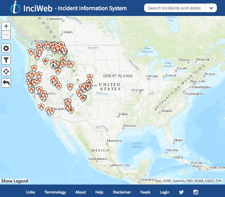
The most profound and noticeable change is there is no longer a table that lists multiple fires, along with the agency, state, acres, and how current the update was. The table in the version that disappeared in March could be sorted with a single click on one of the headers and then you could click to see successive pages each with 10 additional incidents. You could view the largest fires, those most recently updated, all fires in Utah, or see all the fires on the Umpqua National Forest grouped together, for example. The system also had the ability to only display fires in one state, by clicking on “Select a State” at the upper-right.
The new system has a “Search incidents and states” option too. But when you type the name of a state in the box the image simply zooms the map to that state. This is helpful only to someone who can’t find a state on a map.
With the revised system there are two ways to get detailed information about a fire. If you know the name you can look for it in the pull-down list at upper-right.
If you know what region of the country the fire is in you can zoom the map to that area. Then you can manually search fire-by-fire by hovering a mouse pointer over an icon until a fire name appears. Clicking adds a little more information — the acres, when it was updated, and the containment percentage. (Containment was apparently added for those who incorrectly assume it actually is reliable information.) Clicking on “Go to incident” displays all of the basic data about the incident. Other buttons to click on then include Announcements (which from my experience are almost never posted), Closures, News, Photographs, and Maps. I don’t know what the difference is between Announcements and News.
There are some features I like about the new version of InciWeb. The overall appearance is clean and modern looking. The map on the home page is much larger than in the previous iteration, and the thumbnails of photos and incident maps are also a little larger.
The platform also seems to be more stable and probably has more capacity for hosting site visitors. It also loads fairly quickly. At times over the years it would crash on a regular basis, sometimes for days. The first time we wrote about the site was in 2008 after it had been intermittently up and down. Here is an excerpt:
…But when there are many fires burning, or there are one or two that generate a lot of interest, the web site can’t handle the load and chokes, not working at all. When the need for it is the greatest, it is most likely to fail.
And in 2013 we wrote:
If a site with this purpose can’t have at least 99.99 percent uptime, and load a page reliably in less than three to four seconds, it needs to be put out of its misery.
The big negative, as described earlier, is that a table with an overview of groups of 10 fires, sorted by one of six criteria of your choosing, is no longer available. It also was a good method of finding a particular fire, rather than hunting icon by icon in the current version. Removing this feature is a step backward for anyone interested in learning about or monitoring fires in their local unit or state, or wants a list of all of the fires ranked by size. Previously every fire could be seen at a glance by continuing to click on “next” above the table.
A couple of months ago we asked Christine Schuldheisz, a Public Affairs Specialist with the U.S. Forest Service who is the business lead for InciWeb, why the overview table was discarded:
The redesigned website is the result of collaboration between local, state, tribal and federal agencies across the country. Dozens of InciWeb users from these agencies provided input on how to improve the website and participated in extensive testing of it. Based on feedback and testing we decided to remove the table and replace it with an interactive map for users to view incidents based on their location. A user can use the map or search bar at the top to search by incident or state.
[Update at 5:03 MDT September 11, 2018: Ms. Schuldheisz just notified us, after she read this article, that there is a way to view a list of fires. At the bottom of the home page, in the footer, click on Help, and in the “Web Accessibility (Section 508)” paragraph there is a link that will bring up a list for the visually impaired. She said, “We are adding a filter and a some other features to this table to make it easily found in the footer.” We checked out the table and it is sorted by update time, with the most recent on top. There is no apparent way to sort the column of your choice.]
Now, finding a particular fire can be challenging. So much so that the mangers of InciWeb are ordering agency personnel who post fire information to delete non-active fires, as well as “media” and especially videos when they are no longer current. This is to free up needed storage space, Ms. Jones told us, and to decrease the clutter of icons on the map to make it easier to find an active fire.
We will be posting another article about the implications of purging fire information from the site.

A poll we conducted in July found that 47 percent of the respondents preferred the old version of InciWeb vs. 33 percent who liked the new edition better.
What do you think about the changes to InciWeb?
Shots fired toward firefighters in Washington state
Four firefighters felt they were targeted, including two from Australia
Continue readingSan Diego Gas & Electric makes their Air-Crane available year-round
Previously it was on contract for four months each year
Continue readingSingle engine air tanker modified for night firefighting
 Air Tractor AT-802A, N802NZ, owned by CO Fire Aviation. Photo by Aviation Specialties Unlimited.
Fighting fire at night can be more effective because the fire usually spreads more slowly when the temperatures are lower, winds calmer, and the relative humidity is higher. A small percentage of helicopters are used for night firefighting but no fixed wing air tankers have yet ventured into that realm.
A company in Colorado has modified one of their air tankers for night vision goggle (NVG) operations. CO Fire Aviation has worked with Aviation Specialties Unlimited, Inc. (ASU) to add night firefighting capability to one of their Air Tractor AT-802F single engine air tankers.
Since 1995 ASU has modified more than 1,300 aircraft for aerial application at night, including the Thrush S-2R, PZL-Mielec M18, and rotorcraft such as the Bell 206 and OH-58A, but the AT-802 is the first fixed-wing aircraft they have modified that is dedicated to firefighting.
CO Fire Aviation uses their eight AT-802F air tankers on a number of state and federal contracts.
“Having operated NVGs in a variety of operations, our pilots knew that implementing a comprehensive NVG program would be the most significant way we could improve the safety and effectiveness of our aerial firefighting operations,” said CO Fire Aviation Chief Pilot Chris Doyle. “ASU’s experienced team has a strong track record with aerial applicators and we trusted them to equip our aircraft and help us launch our NVG program.”
Half of the CO Fire’s 14 pilots are currently NVG certified including two FAA-approved NVG Instructor Pilots who will be establishing an in-house NVG training program.
“Our pilot cadre has a wealth of extensive NVG experience,” said Doyle.
He explained that several of the pilots have military experience providing close air support during combat with the A-10 Thunderbolt “Warthog” aircraft and were U.S. Air Force Fighter Weapons School Instructors. Doyle has more than 26 years of flight experience and more than 10,000 accident-free hours of flight. He is a factory certified Air Tractor 802 instructor, and was also a Maintenance test pilot for the military weaponized version of the AT-802 in the Middle East along with a number of his current pilot cadre who were the weapons and tactics instructors.
“There is currently no other company in the world with more AT-802 NVG experience than CO Fire Aviation,” said Doyle.
“Later this year CO Fire will be conducting studies to refine and develop NVG firefighting tactics,” said Doyle. The study will involve developing safe and effective drop heights across a variety of illumination levels in different terrain. For example, dealing with moonlit and starlit-nights and low-light scenarios, working toward setting requisite minimums for illumination levels for terrain and drop height.
“We are always looking for innovations to help us lead the way in safety,” Doyle said.
Thanks and a tip of the hat go out to Chris.
Typos or errors, report them HERE.
Senators ask USFS to keep operating the HC-130H air tanker until end of year
The USFS plans to shut down their HC-130H air tanker program September 17, 2018
Continue reading