
Very heavy rain could produce flash floods, mudslides, and life-threatening debris flows
Continue readingJupiter, seen at 130,000 mph

Above: Photo of Jupiter taken by NASA’s Juno spacecraft. Processed by NASA/JPL-Caltech/SwRI/MSSS/Gerald Eichstädt/Seán Doran.
While NASA’s Juno spacecraft is orbiting Jupiter at 130,000 mph, it takes photos every 53 days that are unlike anything I have ever seen. They are beautiful.
This last batch released by NASA was taken during the craft’s 10th close pass over the planet December 16.
Since the distance between Jupiter and Earth is about half a trillion miles (562,382,633 miles today, but it varies) it takes a long time, days or weeks, to transmit the photos back to Earth.


Field tests of tracking devices for firefighters
We have often advocated the Holy Grail of Wildland Firefighting, which is knowing the real time location of firefighters and the fire.
There are many different technologies and platforms for collecting and displaying data about the location of the fire, but the information collected has yet to become commonplace in the hands fireline supervisors on the ground.
A similar situation exists for tracking the location of firefighting resources — personnel and equipment. The technology has existed for years, but the “deciders” in the National and State capitals have not recognized its importance for providing situational awareness, so it is only being used in a few scattered areas.
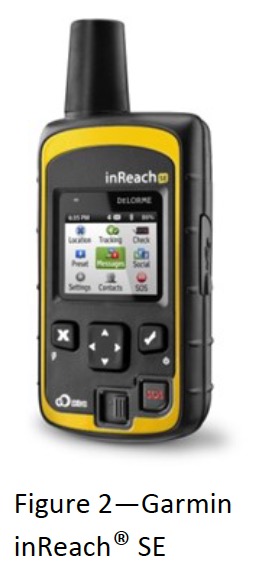
The Colorado Center of Excellence for Advanced Technology Aerial Firefighting (yes, they are still using that name) recently evaluated and tested two consumer-level personal tracking devices, the SPOT Gen3® and the Garmin inReach® (formerly known as the DeLorme inReach).
The executive summary from their report is below. The full document can be downloaded HERE.
Executive Summary
Wildland firefighters frequently operate in remote areas and are often a significant distance away from their supervisors or other nearby units. Additionally, wildland firefighters typically communicate with voice radios operating in analog mode, which does not facilitate location tracking or other digital situational awareness. One technology proposed to overcome these limitations and provide GPS location tracking and messaging for firefighters is satellite messengers. The Center of Excellence for Advanced Technology Aerial Firefighting (CoE) was requested to conduct a study of these devices to analyze their utility for firefighters. This study illustrated the technical specifications of two consumer-grade satellite messengers, the SPOT Gen3® and the Garmin inReach® (formerly known as the DeLorme inReach), and provided information on service options and costs. The study also assessed the capabilities of the SOS feature common to both devices and employed field trials to evaluate the performance of the devices in various types of vegetation and terrain.
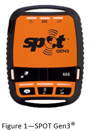 The CoE found that the SPOT device provides a one-way flow of information from the device user to others using predesignated email addresses, text messages, or website access. This device requires programming ahead of use to designate the time interval for location tracking, as well as the content of the three types of messages it can send. The inReach device provides a two-way flow of information, with others able to communicate with the device user via email, text message, or website.
The SPOT device successfully transmitted a test SOS message from a meadow with a clear view of the sky, which then led to the Colorado Division of Fire Prevention and Control Duty Officer being notified of the SOS within 3 minutes. The SOS testing scenario was on a prescribed pile burn under the control of the area interagency fire management unit and the plan was for the Duty Officer to contact the interagency dispatch center regarding the SOS and have them establish radio contact with the unit in distress. Unfortunately, the phone system at the dispatch center was down during the test and no notification could be made. The CoE recommends that for mission-critical applications like wildland fire, the SOS feature be tied directly into relevant computer-aided dispatch systems—a complex requirement for interagency centers that frequently host firefighters from off-unit and from a variety of agencies.
 To determine the utility of the satellite messengers for personnel tracking, six field trials were conducted—two each in minimal, moderate, and heavy forest canopy. For each level of canopy, one test was conducted in rolling terrain and one in rugged terrain. These tests sought to establish the rate at which the location of a firefighter walking the perimeter of a simulated 100-acre fire with both devices set on a 5-minute tracking interval would be known to a supervisor watching in real-time via an Internet connection.
The CoE determined that both devices can transmit location information successfully with minimal delays when used under minimal and moderate forest canopies. However, under a heavy forest canopy the devices experienced difficulties. The SPOT device failed to transmit 20% of points and the inReach device took more than 5 minutes to transmit 50% of points (and during one test, failed to transmit 35% of points). The CoE recommends shortening the tracking interval when operating under heavy forest canopies to increase the odds of successful transmissions and cautions against relying solely on these devices to achieve situational awareness for firefighters operating under heavy forest canopies.
Arizona Forest Service officer involved in shooting
(UPDATED at 11:22 p.m. MST January 8, 2018)
The FBI released more information Monday about the January 5 shooting in Arizona that left one person deceased:
A Forest Service Officer stopped to render assistance to a vehicular traffic accident. An altercation occurred between the officer and the subject, Tyler Miller of Kansas. It was later determined the officer was injured and treated on the scene by EMS personnel. Miller was shot and transferred to a medical center and later declared deceased.
***
(UPDATED at 12:50 p.m. MST January 7, 2018)
According to KWCH, the person killed in the shooting that involved a U.S. Forest Service law enforcement officer January 5 has been identified as Tyler Miller. The uninjured USFS officer has not been named.
The FBI says 51-year-old Tyler Miller was injured and later died at a hospital. The officer’s name was not released, he suffered no injuries.
According to the office of the Kansas Secretary of State, Miller is the owner of TNT Bonding in Hutchinson [Kansas]. The family’s attorney, Matt Bretz, says Miller is a well-respected entrepreneur from Hutchinson.
The FBI says Miller was involved in a wreck earlier that evening.
***
(Originally published at 8:14 a.m. MST January 6, 2018)
A U.S. Forest Service law enforcement officer was involved in a shooting Friday January 5 north of Sedona, Arizona. According to local media the officer was not injured but one person was transported and pronounced dead at a hospital.
State Route 89A was closed for about five hours as the FBI investigated the incident.
On December 11 a wildland firefighter for the U.S. Forest Service was shot while driving a vehicle in Monterey County, California. The victim, Division Chief Peter Harris, was shot in the neck and ear. The suspect, Jacob Kirkendall, fled but was found and arrested.
In 2012 National Park Service Ranger, Margaret Anderson, was shot and killed in Mount Rainier National Park in Washington state.
Thanks and a tip of the hat go out to Tom.
Typos or errors, report them HERE.
Our tenth year begins
Wildfire Today started January 6, 2008
Continue readingIs a little pre-fire mitigation around structures better than none?
According to experience from Colorado’s Fourmile Canyon Fire, sometimes the answer is “No”.
Continue readingLast year’s California wildfires, graphically
Some people learn or are stimulated most effectively by reading, or hearing someone talk about a subject. Others, like myself, respond better visually. For me, there is truth in the old saying, “A picture is worth a thousand words”. So I can appreciate well-thought-out graphics that tell a story.
Lauren Tierney started her job with the Washington Post’s graphics department in November and yesterday she had her first graphics story published. If you click on the image in the Tweet below, the perimeters of wildfires that burned last year in California will be superimposed around an outline of the District of Columbia.
Just published my first graphics story for @PostGraphics (working with the awesome @Timmeko @emamd & @chrisalcantara)! “The grim scope of 2017’s California wildfire
season is now clear. The danger’s not over.” https://t.co/jfV1ILGG1l pic.twitter.com/vePfPjE4CD— Lauren Tierney (@tierneyl) January 4, 2018
The article at the Washington Post website has additional fire-related graphics. One shows all of the 2017 fires on a map of California, and another allows you to choose which city you’d like to compare to the Thomas Fire, which became the largest in the recorded history of the state.
Frankly, when a reporter compares the size of a fire to a city, like, “The XXX Fire is the larger than Pittsburgh”, that does not mean a lot to me. But these maps take it to a new level.
I had occasional problems getting all of the graphics to render properly using the Chrome web browser, but they worked fine with Firefox.
More evidence of the “fireproofing effect” of insect outbreaks in a forest

Additional research finds evidence of a “fireproofing” effect on host trees from defoliation due to western spruce budworm outbreaks.
Continue readingNPS to hire branch chief for aviation

Above: National Park Service photo.
The National Park Service is expecting to hire a National Aviation Program Manager to fill the position vacated last month by the retirement of Jon Rollens. The GS-14 position provides leadership and direction for NPS aviation programs with specific emphasis on national aviation policy, standards and procedures.
There is only one “selective placement factor”. Applicants must have at least 90 days of wildland firefighting experience.
A pilot’s license is not required.
Skills the candidates should have include knowledge of:
- Aircraft and associated support systems for resource management;
- Wildland fire management, law enforcement, search and rescue, and related flying activities;
- Evaluation and audit processes for aviation safety and risk management analysis.
Neither Mr. Rollens or his predecessor, Susie Bates, were pilots.
Before becoming NPS Branch Chief of Aviation in 2011, Mr. Rollens was the Regional Aviation Officer for the U.S. Forest Service’s Northwest Region for nine years. From 1997 through 2002 he was a National Aerial Attack Systems Specialist for the Forest Service, and before that, a Helicopter Operations Specialist for the USFS Intermountain Region.
#NowHiring – @FireAviationNPS seeking branch chief for dynamic & complex aviation program; duty station @BLMNIFC, Boise, ID.
NPS uses fixed wing, helicopter, & unmanned aircraft systems (UAS) resources to support multitude of NPS programs & missions. https://t.co/4iXZ1S8LX1 pic.twitter.com/2Q3tHvAtr7
— NPS Fire & Aviation (@FireAviationNPS) January 2, 2018
Our opinion:
The National Park Service, the U.S. Forest Service, and the other federal land management agencies would benefit from having qualified pilots in their top regional and national aviation positions. We have been told that the USFS National Aviation Officer is not a pilot and only one of their Regional Aviation Officers is. A person in these jobs who does not know what they don’t know can be dangerous.
For a position that leads the entire aviation program, if it comes down to two applicants, one with 90 days as a wildland firefighter and another with a pilot’s license, the pilot should get the nod. Most of the complexity in these positions is on the aviation side, not the firefighting aspect. There is a great deal of fire expertise in the organizations that the Aviation Officers can tap into. A wealth of specific and detailed aviation knowledge from a pilots perspective is more rare.
Federal hiring procedures are ridiculously complex, but these agencies should figure out a way to be able to hire at the GS-13 and 14 level, a pilot with extensive program management skills, even if they don’t have firefighting experience.
Wildfire potential, January through April

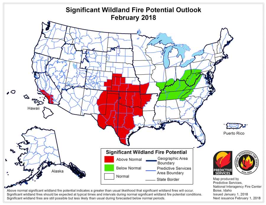
Above: wildfire potential for January, 2018.
(Originally published at 12:55 p.m. MDT January 2, 2018)
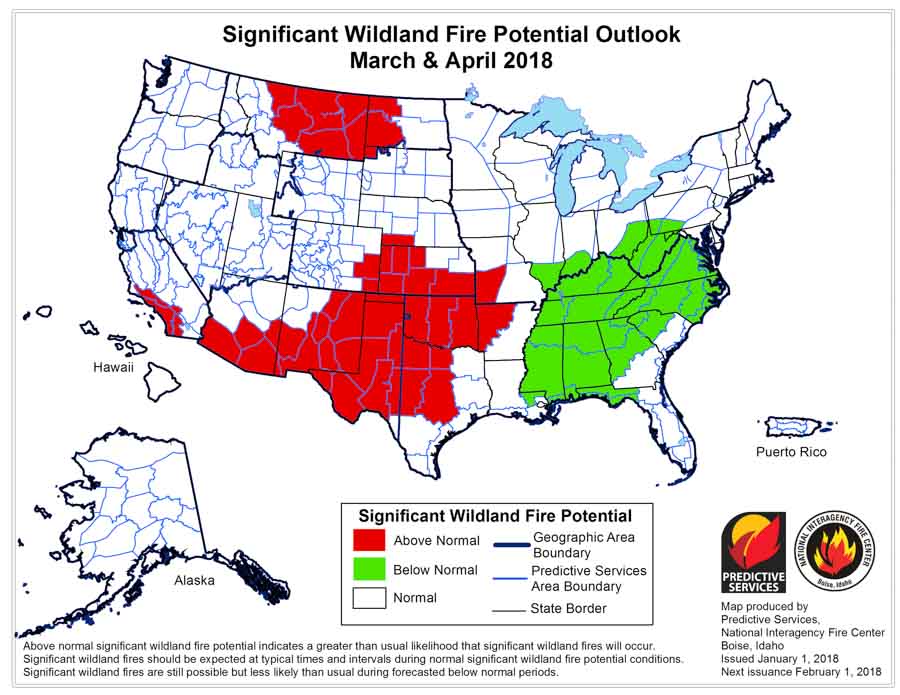
On January 1 the Predictive Services section at the National Interagency Fire Center issued their Wildland Fire Potential Outlook for January through April. The data represents the cumulative forecasts of the ten Geographic Area Predictive Services Units and the National Predictive Services Unit.
If the prediction is accurate, Southern California should see higher than normal wildfire activity throughout the period, with increasing potential in the southwest and southern great plains. The forecast for the southeast is for normal to below normal activity.
Below are:
- The highlights of the NIFC narrative report for the next several months;
- NIFC’s monthly graphical outlooks;
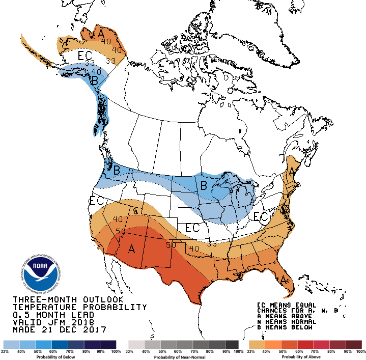
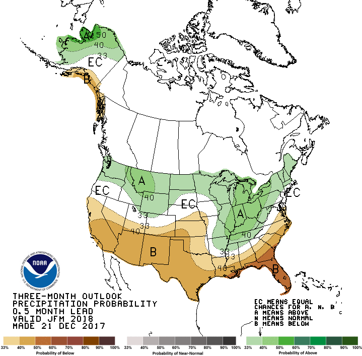
- NOAA’s three-month temperature and precipitation forecasts; and
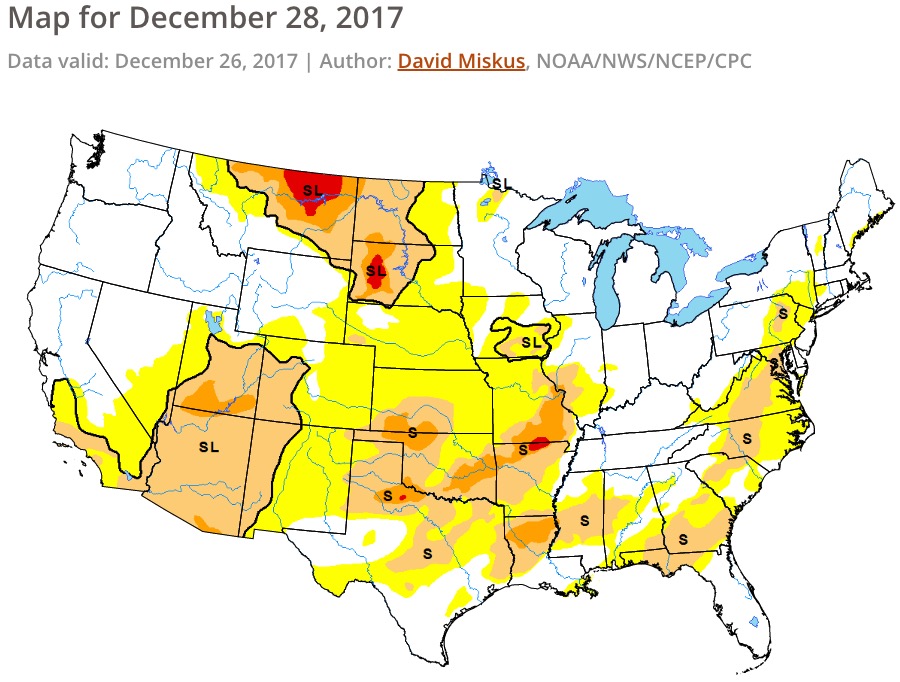
- Drought Monitor.
“…Looking forward, a less amplified pattern is expected to develop for January and February with the mean position of the high pressure ridge being along or just off the West Coast. This should result in overall slightly colder than average conditions in northern areas with pockets of above average precipitation over the Northwest and Great Lakes regions. There is some concern that an active, westerly flow could produce overall warmer and drier than average conditions in March and April in these areas. Across the southern tier of the country, the overall warmer and drier than average conditions will continue through February and into March and possibly April. For this outlook period, the areas of note for increased fire potential will remain Southern California and the southwest. The Great Plains could see periodic increases in activity when wind events arise.”
Cheers to a new year filled with fire, conservation and helping make this beautiful earth even better, one #rxfire at a time.
— FireScience.gov (@FireScienceGOV) January 2, 2018