8:09 a.m. PDT October 29, 2019

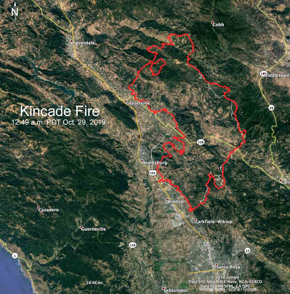
On Monday the Kincade Fire grew a relatively small amount, all of it on the east and southeast sides. CAL FIRE reports that the official size is 75,415 acres. (see map above)
The weather on Monday gave firefighters the opportunity to make significant progress on the fire. But on Tuesday and Wednesday much of California is under a Red Flag Warning for strong winds and low humidity, including the Kincade Fire area.
Below is the National Weather Service forecast for wind and humidity near the fire at Geyserville. The wind barbs point to the direction the wind will be from. After 2 p.m. Tuesday the prediction is for 14 to 16 mph sustained winds out of the northeast with gusts of 21 to 33 until 4 a.m. Wednesday. The humidity will reach into the single digits and there will be no clouds or chance of precipitation.

CAL FIRE reports that 57 homes and 5 commercial structures have been destroyed.
Resources assigned to the fire include 549 engines, 42 water tenders, 27 helicopters, 86 hand crews, and 66 dozers for a total of 4,548 personnel.
Many fixed wing air tankers have been used on the fire. The 747 Very Large Air Tanker (VLAT) has been activated as well as four DC-10 VLATs. These and other tankers, such as the C-130, 737, BAe-146, RJ85, P-3, and MD87 are being used on CAL FIRE and U.S. Forest Service contracts throughout California as fires erupt. There could be more if needed, but the Forest Service has not awarded the Call When Needed contracts for backup air tankers that was first advertised 517 days ago. The eight C-130 military Modular Airborne Fire Fighting System, MAFFS, could also be activated.
Viral photo of Chicago couple captures joy and sorrow of Sonoma County wedding as #KincadeFire glows in the background https://t.co/i1qSIkpAKS pic.twitter.com/yaXhx35B4I
— KPIX 5 (@KPIXtv) October 29, 2019
7:14 a.m. PDT October 28, 2019
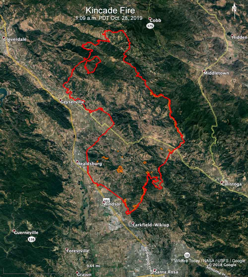
Strong northeast winds that continued Sunday pushed the Kincade Fire to Highway 101 south of Healdsburg, California. The map below indicates that the fire may have been stopped before entering the city.
Two firefighters were burned yesterday. CAL FIRE spokesperson Jonathan Cox said one firefighter with serious burn injuries was airlifted to University of California Davis Medical Center.
Sunday afternoon CAL FIRE reported that the fire had burned 54,298 acres, but an overnight mapping flight found that number had increased to nearly 80,000 acres. Approximately 94 structures have been destroyed and 17 damaged.

Pacific Gas & Electric said they cut off the power to almost a million customers to hopefully prevent their power line infrastructure from starting fires. The wind in the Kincade Fire area is expected to be just 2 to 5 mph on Monday, but is predicted to increase to 10 to 15 mph with gusts above 30 on Tuesday and Tuesday night.
“Due to the dynamic and changing weather conditions, and high fire risk, some customers who are currently out of power may remain out throughout the duration of the next potential PSPS event,” PG&E said.
Resources assigned to the Kincade Fire include 352 engines, 28 water tenders, 10 helicopters, and 51 dozers for a total of 3,441 personnel.

Thanks for this most valuable perimeter view. Why is it so hard for this to be available everywhere?
Ron, go to http://www.readyforwildfire.org
There are links in that website for Evacuation orders, and just about everything else.
I also found these links:
http://www.fire.ca.gov
http://www.maps.arcgis.com