September 14, 2020 | 10:35 a.m. PDT
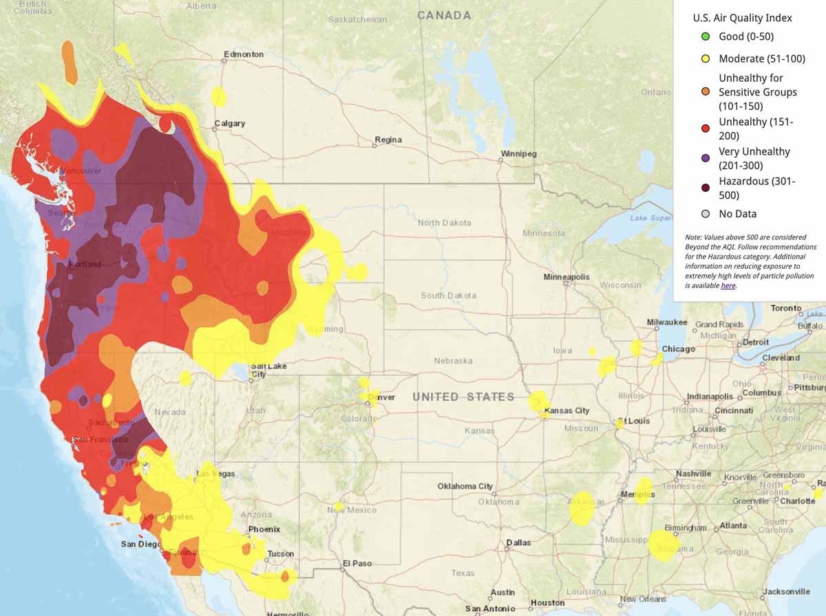
The fires in Oregon, Washington, and California continue to produce large quantities of smoke affecting air quality in those states and portions of Idaho, Montana, Wyoming, Nevada, and Arizona.
The forecast for Tuesday, below, shows improvement in the San Francisco and Los Angeles areas.
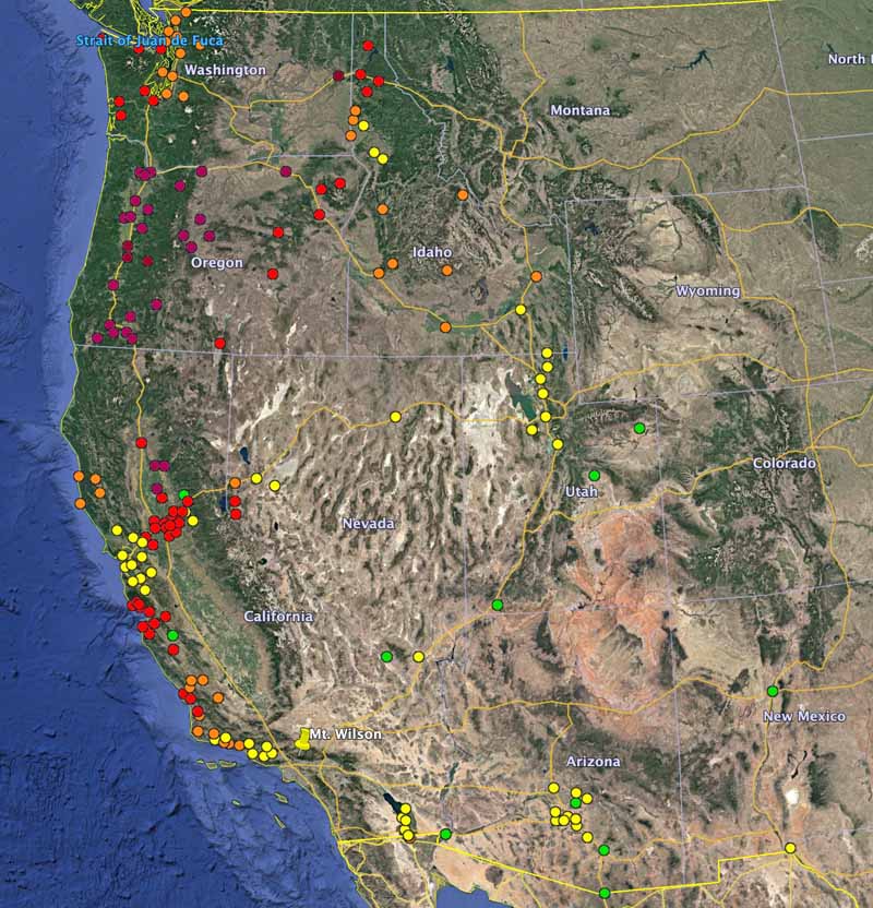
(Information on Wildfire Today about how to reduce your exposure to smoke.)
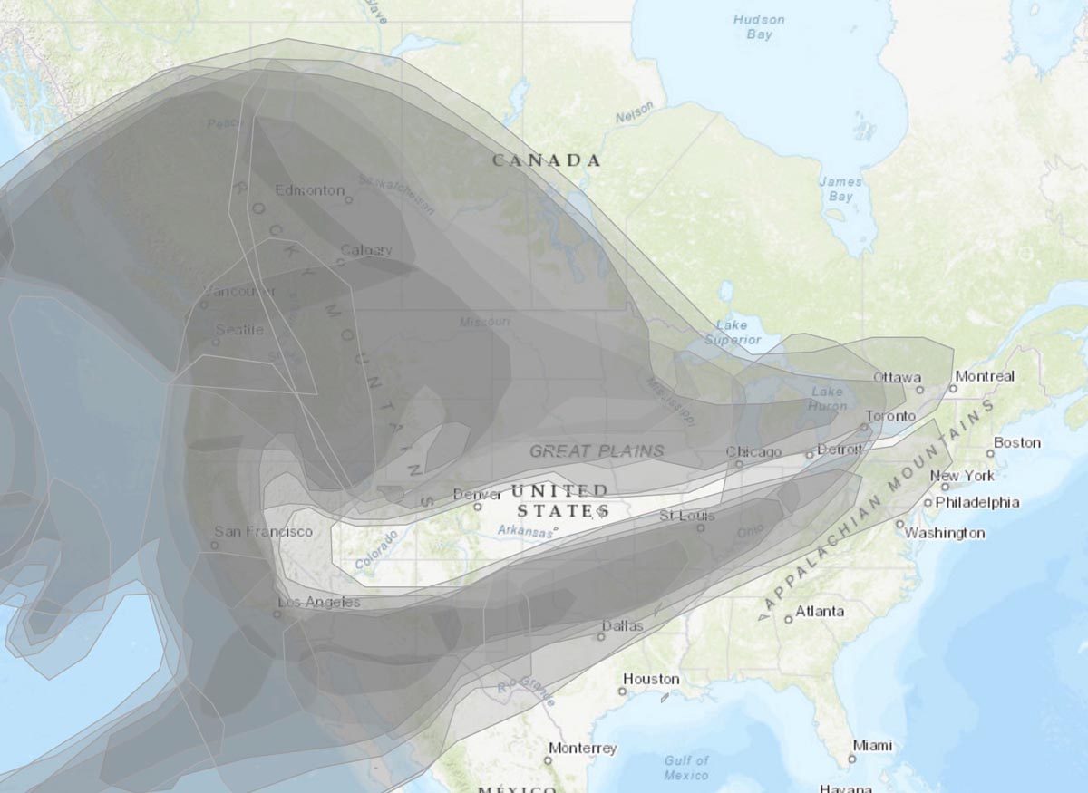
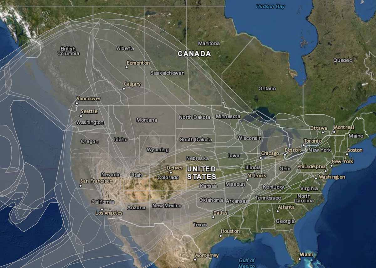
Below is current information about smoke dispersion across the U.S. and Canada. It is tough to find good, easy to read maps that show concentrations of wildfire smoke across the United States. The backgrounds in some cases obliterate the smoke information or the state boundaries.
If you find a good smoke map, let us know in the comments.
The NOAA webpage with the map below sometimes has smoke data, and sometimes it doesn’t. It also has this, seen today September 14, 2020: “Please note that this web page that you are currently on will be permanently retired on September 7, 2020.” There is a link to a different page, but I was unable to quickly find a substitute map.
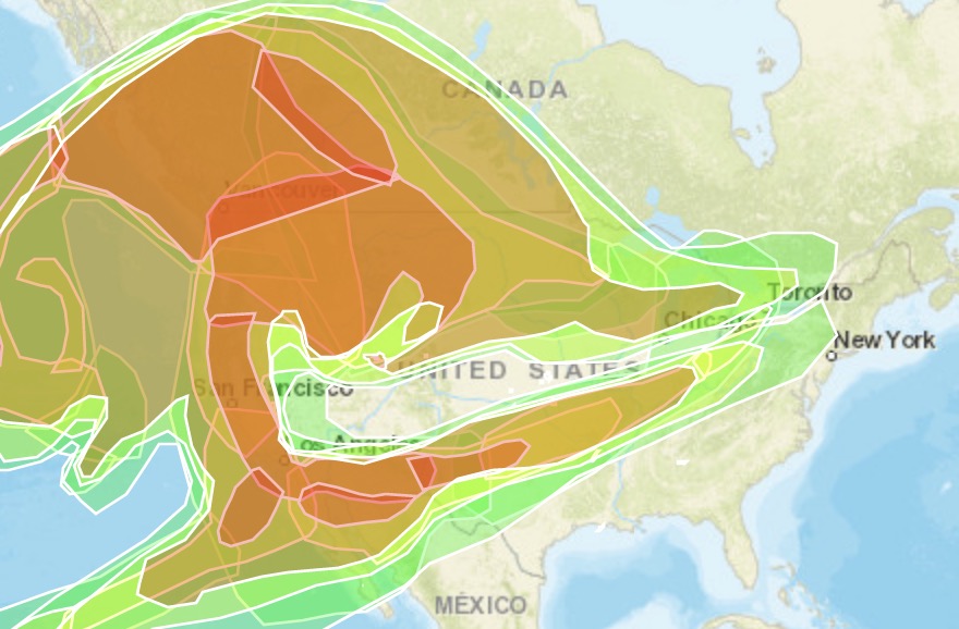
The next two maps from AirNow have the same smoke data, but there is a choice of two background maps, terrain or aerial.

Trying to understand why different websites give such different aqi numbers. Right now, aqicn.org says we’re at 30 and Wunderground says we’re at 171, and other sites are somewhere between. Apparently aqicn.org is run by the EPA and wunderground by the European Copernicus model. Who the heck do we believe?!!!
Hello everyone. First I have to say that our hearts go out to all the folks on the west coast of the U.S. 2020 is proving to be a horrible year all around. We have had terrible smoke for eight days now. This morning I could not see anything pass my neighbors house behind us. It is like a pea soup fog out there. Really bad! It has been like this pretty well the whole time. We have been waiting for the skies to clear so we can go out for a motorcycle trip. Now we are just hoping for some wind and rain. Yikes, this is horrible.
Hi, I am in Calgary, AB, Canada. The smoke isn’t too bad here yet. A few years ago we had a summer of smoke from B.C. fires and I referred often to the mapping on Environment Canada’s website. I think it is easier to read than the maps you posted. The website is weather.gc.ca. If you search smoke map it should come up, and shows all US and Canada. I am supposed to be going on a trip to Penticton, BC next week and have to decide to cancel or not. Is there any decent forecasting of the smoke? Thanks, Laura
Wasn’t the 1st fire started by gender reveal pyrotechnics gone wrong and wasn’t some one arrested twice for starting fires along a highway?
Thank you for this map that is not behind a paywall or forcing me to subscribe to something. Much appreciated.
It’s more than obvious that Governors of Washington Oregon and California have got to focus more attention on wildfire PREVENTION !!!!!
Stop blaming it entirely on climate change, or lighting!
The Federal government owns 70% of these forests. Quit blaming the governors.
If you had ever been in these places, in California at least, you would know that it is very rough country. There are many canyons that can’t even be hiked. It is impossible to use traditional forest management. It hasn’t rained in 6 months and we’ve had record hot weather – the government can’t manage these things.
The Federal Gov’t may ownthem, but state regs control them. States can block federal action.
Even more important: fire is *necessary*. Try to block it and eventually nature will forcethe issue. Today’s fires are still quite low by historical standards.
its your precious infrastructure and safety nets like electricity and automobiles that cause most “wild”fires. you are blaming politics because you cannot face fear of death head on (its an avoidance). i hope people like you mature before our species kills itself and everything else on this rock.
I like this site for a snapshot of the country so I can see where relatives live. Thank you, Joseph,for the link showing wind patterns, that is exactly what I was thinking about. (https://www.iqair.com/world-air-quality)
Here are a few links I’ve been using:
Airnow.gov – put in your zip and it zooms to your town at the current time – this is the only one I’ve seen that shows the current time within an hour or so
https://gispub.epa.gov/airnow/ – zoomed in view with options for today, tomorrow, archive, loop
https://fire.airnow.gov/ – shows smoke pattern density and fire locations
https://fires.airfire.org/outlooks/nworegon#Portland – statements for our area
https://www.co.washington.or.us/CAO/daily-wildfire-update-09142020.cfm – – statements for our county
https://cfpub.epa.gov/airnow/ – the older one but I still compare, you can zoom
On Friday I ordered Merv 16 filter material for the vents and odor neutralizers that should FINALLY arrive tonight (Tues), though tomorrow they predict the air will clear up significantly. We have a Merv 12 furnace filter and if the AQI is over about 275 we can smell smoke inside, like now at 327.
The AQI is 457 outside my house right now (Milwaukie, OR.) I’m seriously wondering how long you can stay in a sealed house before just running out of oxygen…
If you have the funds and room in your home to keep them, go to Fred Meyer or Lowes and buy a few extra green plants. Indoor plants can help contribute to a more equal exchange of O2 and CO2 in a sealed space. A human can theoretically survive for 12 days in a completely sealed room (according to the internet- although they don’t state the size of room). We use much less oxygen then most people think. And since most of our homes have some kind of leakage, more oxygen will get in then we realize, even if it’s smoke contaminated. The real issue is our CO2 exhaust, which can be problematic in closed spaces, and that’s where the plants come in, they absorb it and produce more O2 to boot. Win win. That’s how they create atmospheres on the space stations apparently. Hope this helps, be safe and my gosh, I never wanted rain and a little wind so bad.. Here’s the article I got these facts from:
https://smartairfilters.com/en/blog/does-closing-the-windows-starve-us-of-oxygen/#:~:text=Closing%20Windows%20Has%20Virtually%20No%20Effect%20on%20Oxygen&text=So%20changes%20would%20be%20even,room%20for%2012%20full%20days!
Thank you for the info! I’ve had to drive from Spokane, WA to Kemmerer, WY just to be able to breathe. Good to know where there’s the best chance of clear air.
This is one of the better “heat map” style geographical overviews of global air quality including animated wind, and sensor data.
https://www.iqair.com/world-air-quality
Thank you for this info , it was very helpful. I’m in the okanagan bc area. And the smoke is terrible here. From the air quality map , we’re in the unhealthy – hazardous air quality index. Just going outside for a few minutes makes me feel nauseous. I hope everyone stays safe and prayers to all the people effected by the wild fires across the border
Thank you for being a kind person and sending well wishes to those affected. Smoke and wind know nothing of province, state or country border lines; sorry you are also being affected. Be careful going outside & be sure to protect your lungs.
I appreciate the maps of the West Coast fires. In particular the coverage of Oregon and more so of the Redmond Area as we have relatives there. Good work.
Appreciated the post about evacuation numbers. Glad there are 3 area commands out there. We’re getting evacuees 450 miles away.