Updated September 29, 2020 | 4:57 a.m. PDT
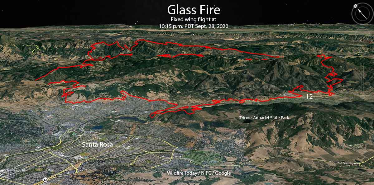
On Monday the Glass Fire at Santa Rosa, California grew in all directions, even as the strong winds that initially spread the fire slowed. But the high temperature and the low relative humidity combined with low moisture in the vegetation combined to enable significant fire growth.
To see all articles on Wildfire Today about the Glass Fire, including the most recent, click here.
At 7:52 p.m. on Monday CAL FIRE reported the fire had burned 36,236 acres. The information from a 10:15 p.m. mapping flight will probably result in another 11,000 acres being added to the total.
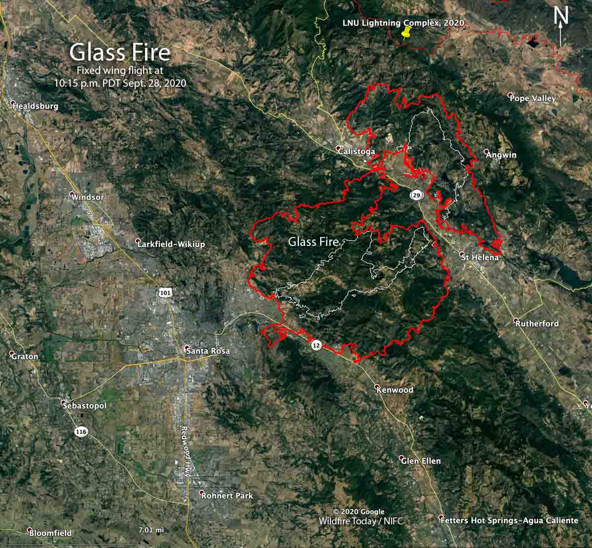
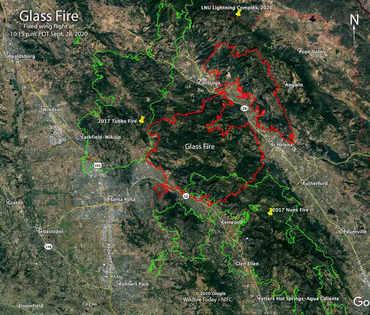
Resources assigned to the Glass Fire include 26 hand crews, 80 fire engines, and 3 helicopters for a total of 1,466 personnel.
Updated September 28, 2020 | 5:22 p.m. PDT
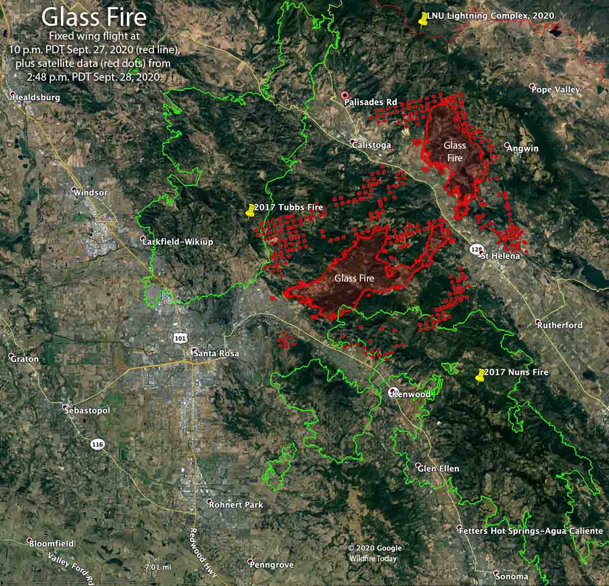
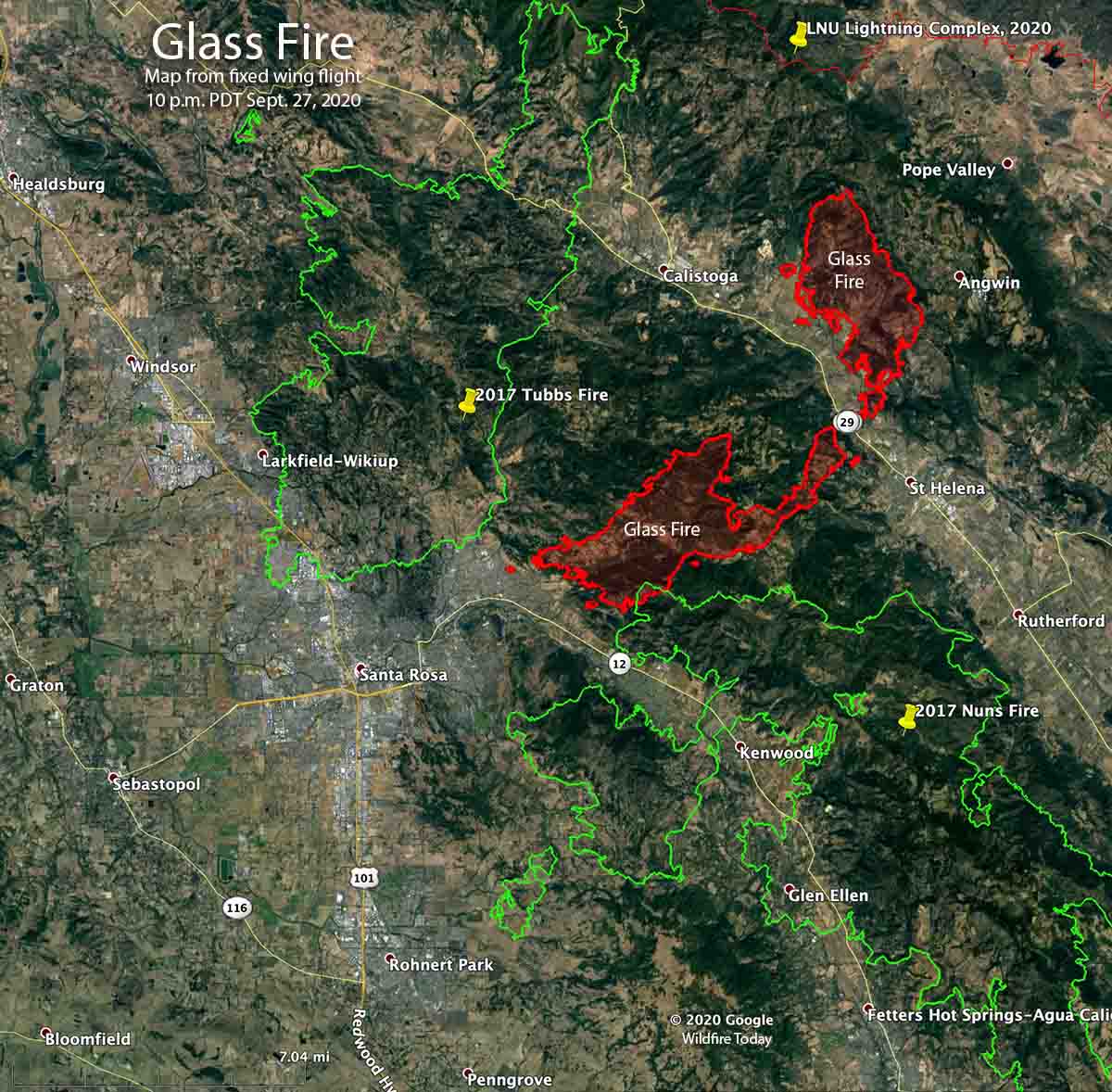
We have an updated map of the Glass Fire in the North Bay area, above, but it should be taken with a grain of salt. The red line was the perimeter mapped by a fixed wing aircraft at 10 p.m. PDT Sept. 27, 2020. The red dots represent heat detected by a satellite 512 miles overhead at 2:48 p.m. PDT Sept. 28, 2020. The red dots could be extreme heat in the smoke column, or fire on the ground. The fire is burning so intensely that debris and burning embers in the smoke have their own heat signature, confusing the sensor on the satellite. But, we have much more confidence in the mapping from the fixed wing aircraft.
Hopefully we will get another fixed wing map Monday night.
Updated September 28, 2020 | 2:16 p.m. PDT
Note: the map below is not current, but it is the only one we have available based on actual observations, in this case, from a fixed wing mapping aircraft at 10 p.m. PDT September 27, 2020. At that time the fire had burned 11,000 acres.
The other maps, below, are derived from sensors on satellites orbiting hundreds of miles above the Earth and can show heat from fire on the ground as well as areas of the smoke column with very intense heat.
We know the Glass Fire has spread beyond the red lines on the map above. It is well established east of Santa Rosa and south of Highway 12 in the Trione-Annadel State Park.
Structures at several wineries have burned and others are threatened.
#meadowood across the valley from St Helena. I just left there…they couldn’t save it. :(. #glassfire pic.twitter.com/rFVCbGrndD
— Adam Housley (@adamhousley) September 28, 2020
September 28, 2020 | 7:30 a.m. PDT
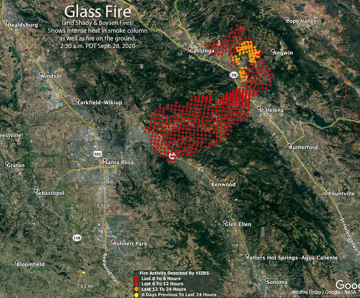
Strong northeast winds have caused at least two wildfires to burn together, the Glass Fire and Shady Fire. The merged fires then spread rapidly from the Calistoga and St. Helena areas of California’s North Bay, southwest into the eastern side of Santa Rosa. At 6:15 a.m. CAL FIRE reported the blaze had burned 11,000 acres.
At about 5 a.m. what we will call the Glass Fire reached the Skyhawk community on the east side of Santa Rosa north of Highway 12, and by 6 a.m. firefighters were battling it near the intersection of the highway and Oakmont Drive.
The Glass Fire started north of St Helena on the east side of Highway 29. As the northeast winds increased, a fire occurred west of the highway. It was named Shady Fire, but may have been a spot fire from the Glass Fire. The two fires burned together and continued moving southwest toward Santa Rosa.
The fire has burned numerous structures and many more are threatened. This very dangerous fire is moving faster than authorities can make evacuation notifications. If you feel threatened do not wait for official notification.
Mandatory evacuations are in effect. For information:
- CAL FIRE LNU (Sonoma, Lake, Napa counties)
- Santa Rosa Police
- City of Santa Rosa
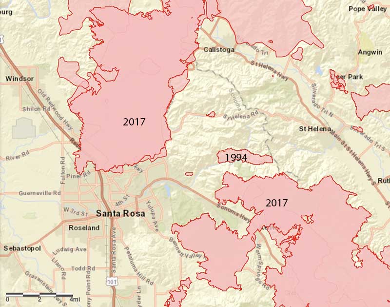
The fire is being driven by strong, dry winds and fuels that have built up in an area that has not seen fire in many decades. Weather stations overnight recorded humidity in the low teens and wind gusts up to 30 mph near Santa Rosa. Winds are expected to decrease through the day on Monday, but the high temperature will be 99 with the relative humidity in the teens. A Red Flag Warning and a Heat Advisory are both in effect.
One of the areas that have lost structures is Deer Park, north of St. Helena.
Dear local friends of Deer Park CA with heavy heart I report that Foothills Elem original building is gone. Dorcas is gone. Community Hall gone. Surrounding homes many destroyed #GlassFire pic.twitter.com/w9ZPA01Q1D
— craig philpott (@CphilpottCraig) September 28, 2020
Another is Skyhawk Drive in east Santa Rosa.
Homes burn on Skyhawk Drive as the #ShadyFire rolls in to east Santa Rosa, Monday morning. https://t.co/llJSkUxhq6@NorthBayNews pic.twitter.com/CymiumfzNL
— Kent Porter (@kentphotos) September 28, 2020

Watch 60 minutes on fires in the west and climate change. Some encouraging news here. https://www.cbsnews.com/news/western-wilfires-record-temperatures-california-60-minutes-2020-10-04/
Karen
Animals need to be back on the land nothing else grass needs to go away for saftey zones and stopping points
I have written this a few times before, but it is time to repeat it. I will not allow this platform to be used for propagating blatantly false information, including on the topic of climate change.
Climate change is proven science. The debate is long over. The Earth does not care if you or anyone believes in climate change. It does not matter if someone does not understand the science. It is a fact and it is happening.
Individuals denying climate change will be welcomed with open arms at some websites, but not this one.
Thanks for your perspective Bill. I agree. I think we’re going to get climate deniers in all online sites, but we can keep sharing the good science that we have available and hope that more people will be brave enough to accept it and start looking for solutions.
Karen
I’ve been looking for Weather Databases & other sources of information about the history of Wind & Temperature in Sonoma County.
Found this, weather records from the Sonoma County Airport.
https://www.wunderground.com/history/daily/us/ca/santa-rosa/KSTS/date/2019-9-28
I’ve been looking all over for recent wind history for Calistoga, etc.
The mainstream media reporting cites a wind event. All I can conclude is, it was briefly windy, the day that it started.
Every day since then, Accuweather, Wunderground etc. wind speeds have all been in the single digits.
Another way to assess wind in Santa Rosa, the Courthouse Cam –
https://www.wunderground.com/history/daily/us/ca/santa-rosa/KSTS/date/2019-9-28
Does anybody know if there is a more centralized database of weather history information for the US ? Like the USPS topographical maps, but weather data.
I grew up camping all over Northern Cal. Love it deeply. Our president has never stood in a redwood forest . Resilliant thru fire… He tells us to rake the woods. In Paradise fires the houses burned and many trees still stand . It is the chaparral and grass yes, that passes the quick fire . I heat with wood in the pacific northwest and know this to start my own woodstove. we do need to burn the underbrush away from homes and use some wood for heat and building ,tho clearcutting old growth only creates a disease vulnerable scar. Combined drought,winds,lightning storms and heat are all demonstrations of Climate change that create extreme fires . If I lived there I would clear a wide swath around my home and plant fire and drought resistant ground covers, and redwood trees when possible. I would clear big fire breaks around cities and install Solar ,not powerlines crossing dry grassy fields. I would also check Fracking intrests who would only be too happy to buy up devalued lands in the area. Fracking causes spark ,earthquakes and water pollution . If the area can be proven unliveable then other intrests can capitalize and take advantage . Native people who lived in these places long years should be consulted, but in any solution ,Lifestyles must adapt to Nature in order to preserve the lives of all the creatures and plants that make the place desirable. Some only desire money.
Kathleen,
I kinda like your idea about planting redwoods. You may or may not know this but when the very first white settlers arrived on the west coast, the East Bay Hills above Oakland were mostly clad in redwoods. It was said that there was one huge triple tree that was so big it could be seen several miles out at sea outside the “Golden Gate”. Early sailing ships used it as a navigation guide!
By 1900 those hills had all been nearly completely denuded and the lumber used to build much of 19th century San Francisco. Yes, it’s true!
There were people who were so sad about the hills being laid bare that some bright people came up with the brainstorm of planting “gum trees” (eucalyptus). They grew fast and soon the hills had a forest on them again. But! eucalyptus isn’t quite as cold hardy as redwood and in the 1970s there was a very bad freeze. Most of the eucalyptus died. Had they just replanted redwoods, they problem would’ve been O.K. (There are, however, some second growth trees in the Canyon area and the Redwood Regional Park).
I actually live in Indiana and I’ve found some cold hardy giant Sequoias that I think might be able to survive our winters. At least I hope so! They’ll make a great “carbon sink”. Plus, they just plain look nice!
Regards,
Fred M. Cain
Fred, I have seen many giant seqoias doing well north of the 45th parallel. Coldest spot at the top of my mind is Moscow, Idaho, but I have fuzzy recollection of some in Missoula too. Happy planting.
To me the most astonishing news recently was when I got to know the wildfires in Oregon on this website. Oregon has been well known for the frequent raining there for years. The roof shingles could turn green during long raining season there (I had a small condo there one time). Every year I wondered if global warming would finally let up. I guess no one has answer for that.
Christina,
I agree it’s bad but it might not be completely unprecedented. The Tillamook burn in the 1930s was pretty bad. Maybe not as bad as this outbreak but there were a lot fewer people living there then.
I remember reading a story about a man that got caught in the Tillamook burn and was unable to get out of there. He found an abandoned mine and took refuge in the mine. That ended up saving his life.
Regards,
Fred M. Cain
#1 We can’t burn wood in a cheap, efficient, controlled manner to heat our homes in California anymore. They banned wood burning fireplaces and stoves years ago, and with it the incentive to limb up trees and cord the wood. The higher-ups want citizens to pay huge amounts for gas and electrical service.
Put one and two together and you have found one piece to the puzzle…
#2 Have you noticed all the particle board furniture with fake wood veneers? Why has real wood and good furniture gotten so expensive? The entire timber industry, from lumberjacks and sawmills to craftsworkers and carpenters, is dieing because certain individuals think logging is bad.
“The entire timber industry, from lumberjacks and sawmills to craftsworkers and carpenters, is dieing because certain individuals think logging is bad”.
Nick,
One thing that I have observed for years is that we are condemned to enduring politicians in Washington and in our respective home states who consistently pass regulations and rules governing industries that they know absolutely NOTHING about.
Congressmen pass laws regulating railroads but they know little or nothing about the railroad industry or how it functions. They pass laws governing airlines or phone companies but know very little about those industries.
It’s the same way with logging. The logging of forests on a sustained yield basis is a time-tested method of forest management. But the many politicians, imposing regs on the industry might not even understand that.
These politicians are mostly lawyers and they understand the law very well. Unfortunately, that doesn’t mean they understand everything. So, what to do? They fall back on the news media for their information. That, in turn, is a disaster. How many times have you seen something in the news on a subject that you know something about that is just plain wrong? That has happened for me many times.
Best Regards,
Fred M. Cain
Thanks, Bill – your original post and response below are right on the money, sadly. And I write that as a native Californian who – aside from only a couple decades, has lived here my entire life. And what you describe re: causation and also the reason for why and how these fires are monumental – are precisely what I observe here, now – just outside Yosemite.
Sadly, the climate change deniers (including our own state/Federal reps) have far too often jumped on the bandwagon blaming ALL our fires on a lack of historic suppression. A demand that the forests be cleaned/cleared out. Which unfortunately, reveals either deliberate misdirection or ignorance, when so many of the fires we’ve been experiencing are in scrub – grazing lands, oak, chaparral – with the rare trees widely distant from one another. The most glaring case in point was the Detwiler Fire in Mariposa County in 2017; while it was still raging, the Congressman for this district railed against the forests – which had absolutely no bearing whatsoever upon ANY of the eventual acreage of that monster fire. That Congressman, incidentally – has proven to be a close friend of the large lumbering/timber interest of a neighboring county, also within this CD.
Bill & Les,
I am trying to understand this as best I can. I do not consider myself to be a true “climate change denier” but, rather, there are a few things I’m skeptical about.
I cannot prove that climate change is either really happening or not happening. At least not here. In the far north above the arctic circle it’s a little more obvious. But *HOW* can “climate change” cause these fires? Can we make a case that “climate change” is producing more extreme droughts and “Santa Ana” winds? Maybe. If we could prove that then how does climate change create an ignition that starts a fire? The August Complex was, indeed, started by lightning but nonetheless, it is still true that the causes of 95% of all fires are human related.
I’m also not quite sure whether these droughts are truly getting worse or not. You mentioned you lived most of your life in California. Well, I wasn’t in California the whole time but I lived in the Southwest from 1958 to 1980 and have kept an eye on the weather there since. I have seen some pretty terrible droughts.
In the 1970s there were millions of pine trees dying in the Transverse Ranges around L.A. Sound familiar? I just happen to remember that – most people don’t. That’s all ancient history now.
I guess the bottom line is, climate change or not, we simply HAVE to get a handle on preventing ignitions. Whether they be transmission or exhaust fires, cigarette butts, abandoned campfires, poor power line maintenance – whatever. If we can’t get a handle on all that then this is going to keep happening.
Thinning trees and performing RX burns do need to be an important part of the picture. But even if we do that, we simply cannot allow an ignition on a hot, windy “red flag” day. That, I believe, is the nut we need to crack and it might just prove to be even more difficult that eliminating green house gases.
Regards,
Fred M. Cain
Dear Fred,
I understand your skepticism. I too am skeptical, on the same and possibly different issues. I worked for federal land management agencies in California and Oregon for 15 or so years and absorbed information on fire and forest management. I have educated myself on climate change, and see the signs of this catastrophe everywhere. I hope that good science from a variety of sources will persuade you and others Fred.
Our earth is warming, some places faster than others, because humans have increased the amount of carbon dioxide (and other gases) in the earth’s atmosphere by 40 percent since the late 1700s. These gases have warmed the surface and lower atmosphere of our planet about one degree during the last 50 years. (1) The heat-trapping nature of carbon dioxide and other gases was demonstrated in the mid-19th century. The current warming trend is of particular significance because most of it is extremely likely (greater than 95 percent probability) to be the result of human activity since the mid-20th century and proceeding at a rate that is unprecedented over decades to millennia. (2)
The signs that I and others see from climate change are here: Average temperatures over much of California have increased, as have extreme temperatures. Extremely hot days and nights have become more frequent since 1950, and have increased at a faster rate in the past 30 years. Increasing temperatures tends to decrease humidity in California and the Southwestern U.S. (3) Low humidity can make fires easier to start and harder to stop. Over the past 50 years, the snowpack in California has been melting earlier in the year. Snowpack has decreased at most monitoring sites in California (1). Glaciers provide the most visible evidence of climate change. Between the early 1900s and 2014, some of the largest Sierra Nevada glaciers lost an average of 70 percent of their surface area (4).
Almost 95 percent of fires in California are caused by human activity (5). If we are able to convince many humans to be more careful California might have fewer fires. Some of the fires in recent years are due to downed power lines and prevention will require corporate decisions and/or state legislation. In Oregon recent fires, caused by Pacific Power leaving the electric transmission lines on during a period of high winds, caused loss of human lives, many structures, and blackened thousands of acres of private and public land (6). Many of the recent fires in California in August of 2020 were caused by a storm with 14,000 lightning strikes within a 72 hour period (7). Scientists at UC Berkley have evidence that lightening increases with increasing temperatures, and they predict that the number of lightning strikes will increase by about 12% for every degree of rise in global average air temperature (8).
It’s not just the number of fires that are a problem, but the size and destructiveness of these fires. Wildfires are roaring through twice as many acres per year on average in the U.S. than they were 40 years ago (9). Fires are burning with more intensity, and become larger before weather changes and firefighters can put them out. And the fire season has gotten longer, sometimes going into December (7). All of the changes in current day fires can be attributed to climate change. Rising temperatures increase the rate at which water evaporates into the air from soils and surface waters, which means trees are drying out and dying. Increasing temperatures reduce air humidity, which leaves forests more likely to burn hotter and faster. Drought is another symptom of climate change. The 2020 summer heat wave — in addition to years of intense drought — has made California’s dried out vegetation a particularly effective fuel (9). Climate models indicate that in some portions of the West, future temperatures could rise by as much as 7ºC (12.6ºF) (9).
Can we “manage,” or use harvest techniques on the forests along the west coast to reduce the number and intensity of fires with the climate we have now? Recent research concludes that intensively managed private forestlands tended to burn with greater severity than older, unmanaged federal and state forests in western Oregon (10). So if “better forest management” means clear cuts and plantations, creating more of these forest ages/structures over large areas may continue to enable more, larger fires. If other types of forest management are considered, like thinning of understory vegetation to decrease fuels, an expensive option, it could be used in specific areas. Like those areas where someone is more likely to park their truck on tall, dry vegetation or flick a lit cigarette butt into the weeds. More management of private or public land, along roads leading to homes or recreation areas, should occur to reduce the risk of fire.
Prescribed burning is another management option in some areas (11), but an expensive and potentially risky one. It may be a difficult with our new prolonged fire season to find a window to burn, or to expect the public to want to breathe more smoke at the end of a long fire season. And there is a risk of a “controlled burn” becoming uncontrolled. The US Forest Service in California has struggled with letting specific fires continue to burn to better manage the forest (12).
Maybe more effective than convincing millions of people out in the forests every summer to be more vigilant about preventing fire, or fixing our electric power line failures before the next fire season, is to convince people who live in the woods to be immaculate about preventing fire to get close to their homes, businesses, churches and schools. The pamphlet Reducing Wildfire Risks in the Home Ignition Zone explains more (13).
Because climate change has many repercussions, on top of creating conditions for devastating wildfires, I believe that we need to stop using fossil fuels now, for the sake of current and future generations. Leaving our cars and taking the bus, and switching the energy we use in our home and business from “natural” gas to electricity, and many other possible mitigations, could be easy and cheap compared to the options that we will have in 10 years, if we don’t reduce our greenhouse gases now.
1. https://www.epa.gov/sites/production/files/2016-09/documents/climate-change-ca.pdf
2. https://climate.nasa.gov/evidence/
3. https://www.climate.gov/news-features/blogs/beyond-data/its-not-heat-its-humidity
4. https://oehha.ca.gov/epic/impacts-physical-systems/glacier-change
5. parhttps://www.nytimes.com/2018/08/20/us/california-wildfires-human-causes-arson.html
6. https://abcnews.go.com/US/wireStory/pacific-power-utility-sued-devastating-oregon-wildfires-73368992
7. https://www.pbs.org/newshour/science/californias-catastrophic-wildfires-in-3-charts
8. https://science.sciencemag.org/content/346/6211/851
9. https://www.nationalgeographic.com/news/2013/8/130827-wildfires-yosemite-fire-firefighters-vegetation-hotshots-california-drought/
10. https://today.oregonstate.edu/news/high-wildfire-severity-risk-seen-young-plantation-forests
11. https://www.technologyreview.com/2020/09/17/1008473/wildfires-california-prescribed-burns-climate-change-forests/
12. https://www.sacbee.com/news/california/fires/article230481684.html
13. https://www.nfpa.org/-/media/Files/Training/certification/CWMS/ReducingWildfireRisksHIZ.ashx
The thing that really gets me is just HOW in the heck are these fires getting started to begin with? Many of our politicians and people at the news media are pointing their finger directly at “climate change”. But, come on, people. “Climate change” does not create an ignition to start these fires on “red flag days”.
Is climate change causing more red flag days? Maybe. I can neither prove nor disprove that (and possibly no one else can either) but the bottom line is that a warming climate does not actually set the woods on fire.
California has always had very dry summers. I vacationed in California a LOT 30 and 40 years ago and people simply were not starting fires like this back then. So, what the heck happened?
Regards,
Fred M. Cain
There are many factors that affect how a fire burns after it is ignited. If everything is on the low end of the scale they are much easier to suppress, and you may never hear about it because it is knocked down after burning a few acres. Climate change brings extreme weather of all types. Presently Oregon and Northern California are in various drought conditions, ranging from Abnormally Dry to Extreme Drought. Then factor in very low humidity, strong winds, and shortages of resources. Most of the fires that started on September 8 during the “Siege of ’20” were caused by lightning that was accompanied by little or no rain. The August Complex of fires is the result of 38 lightning-caused fires burning together.
Fire ignitions haven’t necessarily changed, you just didn’t see them previously because they were suppressed (and were suppressable) 40 years ago in the forest fuels regimes that existed at that time (although admittedly I don’t think anyone was having ludicrous gender reveal parties with explosives back then…).
Add 40 years of fuel growth and 40 years of expansion into the urban interface and you get to where we are now – more people out and about recreating, more homes in the forest, more powerlines crossing forested areas to support enhanced power needs, more fuel loading… more everything. It’s not some great conspiracy. It’s just a system that has passed it’s sustainability and we’re finally seeing regular and frequent consequences of what has been building for years.
My thoughts are with everyone on the lines fighting these fires and everyone in these communities who have so regularly been exposed to wildfire, evacuations and tragedy. May you all stay safe.