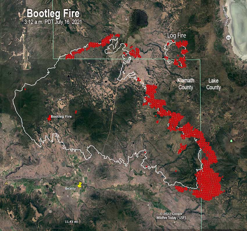
7:40 a.m. PDT July 16, 2021

In Southern Oregon on Thursday firefighters were pulled off some areas of the Bootleg Fire for their own safety. With extreme wildfire behavior causing large fire growth on the north side, it became too hazardous for crews, engines and heavy equipment so they relocated and regrouped.
The southeast side of the fire moved two to four miles east Thursday and crossed into Lake County.
(To see all articles on Wildfire Today about the Bootleg Fire, including the most recent, click HERE.)

In the video below, retired smokejumper and Bootleg Fire Public Information Officer Jacob Welsh narrates from the front lines Thursday afternoon as equipment was relocating.
An overnight mapping flight determined that the Bootleg Fire had burned over 236,300 acres.
The Incident Management Team is also managing the Log Fire. It was active on its east side Thursday when the gap between the two narrowed to four miles.
Evacuation information for the fire is available HERE.


Anybody know what those heavy equipment “claw” machines are and what use they are on a fire line? Other than the dozers and skid-gine, not familiar with that equipment. Thanks!
They’re grapple skidders. Usually they get used with feller bunchers or hot saws to skid the logs that’ve been cut to decks. Same idea as hot saws/ feller bunchers and skidders on logging operations, just being used to make a bigger fuel break than crews could.
Dual arch grapple skidders. For skidding entire trees. A good operator can bundle multiple trees in a single turn and get them out of the way.
I believe you are talking about the skidders I saw go buy on one of the trucks. Used to haul logs out to the landing in logging ops.
One interesting aspect here is on the northern fire edge are two large private landowners. The Nature Conservancy owns and manages the 30,000 acre Sycan Marsh Preserve. TNC is a big advocate of RX burn so wondering if they have been burning much there, particularly on the forested portion. How much of that area that is normally wet and verdant is susceptible to fire in this drought?
West of that is the Green Diamond Resource Company’s timberland holdings (50,000 acres or so?) where the fire was backing into. It is so intensively managed the boundary is visible on satellite maps, even next to the intensively managed USFS lands.
Here’s some additional information about the Bootleg fire.
https://forestpolicypub.com/2021/07/15/bootleg-fire-pyrocumulus-clouds-and-biomass-logging/
Thanks for this very helpful piece. I have been looking at satellite photos as well and (although it is mostly limited streetscape views) much of the country appears to be managed second growth in various degrees of density and development. But little is said of how vulnerable these stands with very low live limbs are even to surface fires. There are roads everywhere.
I read in a history of the Fremont that they were cutting about 140 mmbf a year back in the late 1980s. Last year they sold 71 mmbf but only cut 42. Is this part of that biomass sale? It appears that much of the forest is not good for much else these days.
I did have a question about the Green Diamond lands. At present the fire has only burned into some of that very large holding to the NNW. Do they also own property elsewhere in the area?
During one of the community updates on the Bootleg Fire FB page, they attributed the pyrocumulus, or at least one of them, to the “jackpots of beetle kill” within the area. But the first speaker also described formations in lower fuel areas and in an area where he failed to define the fuel. It seems if there is beetle kill they will go out of their way to mention it, but if there is any logging slash it goes unmentioned. The second speaker spoke of the Gearhart Forest to the southeast, the only wilderness area being affected. But the fire boundary map shows it has not even entered that area yet, it is only abutted it.
https://youtu.be/TMFVuffqyr4?fbclid=IwAR2H0XPx0fCteIla3nmsBbPc0PnH99-MoXBvtOQ0AT0C7cLtL0zerOHCtYE
Hi Bill,
I am 80 years and do not know this modern technology. I have an emailed code (438703) and I do not know what to do with it. But this okay because I know you are busy and I am not because few will write about what I write. I made a comment to you yesterday or the day before and I have no idea of what happened to it.
However, don’t worry about me and keep up the good work of keeping me and others informed.
Have a good day, Jerry
This is the first comment I have see from you Jerry. And, I am not familiar with a emailed code in connection with this website.