This article first appeared on FireAviation.com.
When Bob, one of our readers, asked if I was aware that for several days a high altitude balloon had been seen on a flight tracking app maneuvering at 62,300 feet over the Dixie Fire in California I told him no, but I would check into it.
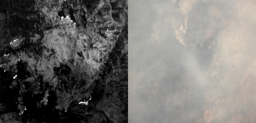
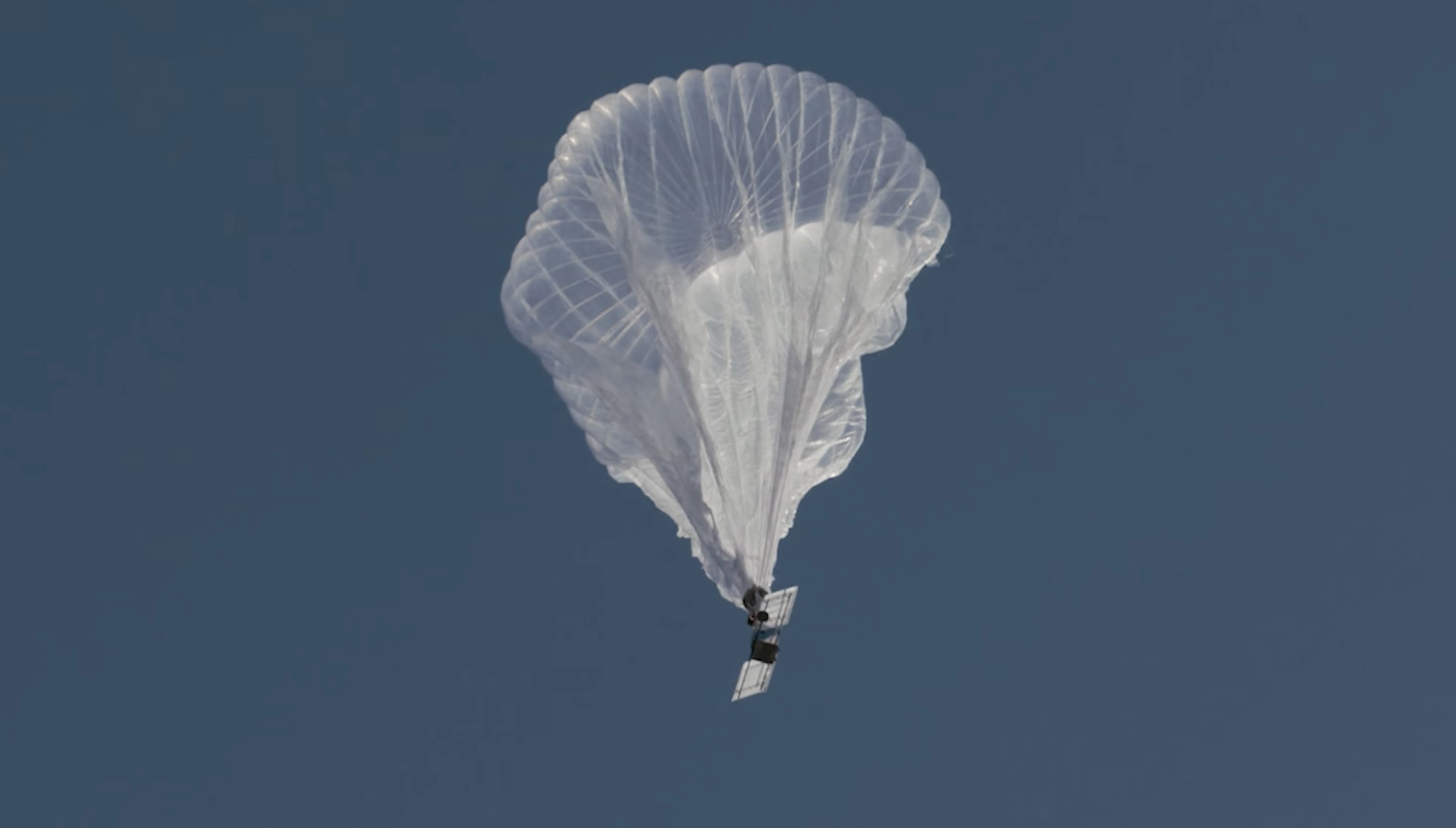
It was operated by Raven Aerostar, a company based near Sioux Falls, South Dakota, which has been working with lighter than air technologies since 1956. We contacted the Communications Manager for the company, Lisa McElrath, who told us that in June, July, and August they launched one of their Thunderhead Balloons from South Dakota and flew it west to monitor wildfires. While traveling more than 16,000 miles during its 70-day flight it engaged in station-seeking above four active fires — the Robertson Draw Fire (Mont.), the Dixie Fire (Calif.), the Dixie-Jumbo Fire (Idaho), and the Dry Gulch/Lick Creek fire (Wash.) — collecting visible and thermal imagery for extended periods of time.

We asked Ms. McElrath if Raven been cooperating with the federal land management agencies in mapping fires. She said not yet, but that representatives from the National Interagency Fire Center had reached out to them and expressed interest in discussions after the fire season slows down.
“We can provide real-time imagery from the balloon today in the visible and infrared,” Ms. McElrath said. “In the future, the goal would be to automate the detection and download of critical imagery, fire perimeters, likely fire-starts, and other key information via onboard processing so that more actionable information would be available. We see stratospheric balloon technology being the key to cost-effective, scalable wildfire surveillance that reduces time between new fire detection and response. Effectively, balloons can alert firefighters to a new fire while it is still small, before the fire grows into something newsworthy and very expensive.”
She said the balloons can also serve as radio repeaters for personnel on the ground and could collect information from tracking devices on firefighting resources which could then be displayed on a map.
There are several paths that could lead to what we have called the Holy Grail of Wildland Firefighter Safety: knowing the real time location of a fire and firefighters. This could be one of them.
There are at least half a dozen companies in the U.S. that are working with high altitude balloons. Google Loon was one of them until they shut down a few months ago. Their goal was to help provide internet connectivity to the last one billion residents on the Earth, beaming it down from balloons. The company announced that it could not become commercially viable, around the time that thousands of SpaceX’s internet satellites were appearing in orbit.
The high altitude balloons navigate to locations by changing altitude to find wind directions that serve their needs.
“For the past nine years, Raven partnered with Loon on the development of this unique technology,” said Jim Nelson, Division Manager of Raven Aerostar. “Loon launched and navigated thousands of balloon platforms to help serve its mission. In parallel, we leveraged the Loon partnership and our 60-year history of balloon expertise to design and build our Thunderhead stratospheric platform. Thunderhead systems navigate using altitude steering, moving up and down to find favorable winds, just as the Loon balloons did. Because no lift gas or ballast is consumed during maneuvering, Thunderhead balloons can remain aloft for weeks to months at a time.”
The stratospheric balloon system works best in fleets or constellations of balloons that share wind information to improve navigation and share the sensor workload. This is explained in the video above.
All of the electrical power on the balloons comes from solar panels, which charge batteries for night operations.
Thanks and a tip of the hat go out to Robert.

Hi
Down under some of our state digital radio networks have an active radio location function. In my state both handheld and vehicle radios have this GPS tracking capability. I use it to track vehicles and personnel on the fire ground.
They also have a distress button which sends out an alert when activated. for handhelds on the same talk group (channel) it also provides a bearing and distance to that radio.
Cheers
Andrew
https://www.firehouse.com/tech-comm/mobile-technology-accessories/news/21240709/ca-firefighters-develop-gamechanging-tracking-software
Hi Bill,
It is amazing what is being done and financed by private companies and creative PEOPLE!!! This is known as a historical fact which exists be seldom READ by the right people because there is so much CHAFF (NON-SENSE) being written and published.
I have no idea how many are READING WILDFIRES TODAY but I am quite certain not enough. I direct some of my friends and family to your existence but I see no evidence they ever take the time to give this SITE a look. And I am pretty certain I wouldn’t have discovered YOU if I hadn’t lost property in the Bootleg wildfire.
We have all this modern technology which takes a crisis for it to be discovered. It took WWII for RADAR to be developed because ???? (don’t remember his first name and you can search for it) Loomis provided a refuge for European Scientists and Engineers to flee what had become their Native Countries.
But those of LIKE MINDS NEED TO MAKE EFFORTS TO INCREASE THE SIZE OF THIS NETWORK of people and share their knowledge of the actual localized ups and downs of the atmosphere’s circulation.
For until I read further my question was: HOW DID THEY FLY THE BALLOONS WEST???
Bill, as you wrote this article, did you really note the fact that the balloons are not traveling in the Troposphere? I almost missed this. Or am I mistaken? Lots of interesting STUFF to ponder!!!
Have a good day, Jerry
Interesting idea. Low cost, real time? I do like the development of drones for use on fires. They are portable, can give accurate real time information and be directed to specific locations. They can also be used 24 hours a day along with low costs. Has any progress be made with outfitting fire radios with tracking devices so they can be instantly be located and resources followed. I’m sure the technology is available. Our cell phones have it.
I agree there is so many uses for Drones on fires today . First think of the safety issues of being able to locate fire teams in danger or fire movement, placement of needed equipment. We use on battlefield and Fire ground is the same battlefield when it comes to life safety !