
8:03 a.m. PDT Oct. 6, 2021
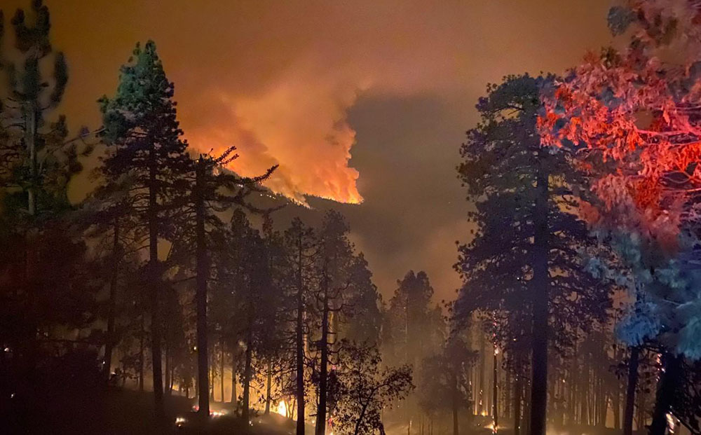
On the KNP Complex of fires in Sequoia National Park in Southern California, the smoke, which has limited the use of firefighting aircraft for days or weeks, cleared by mid-morning Tuesday more than it had in recent days which allowed the use of some aviation resources both on the north and south ends of the fire. An increase in relative humidity has slowed the spread for the last two days, allowing firefighters to construct direct fire line near the fire’s edge where conditions permit.
The blaze was mapped Tuesday evening at 81,473 acres, an increase of more than 20,000 acres in the previous 48 hours.
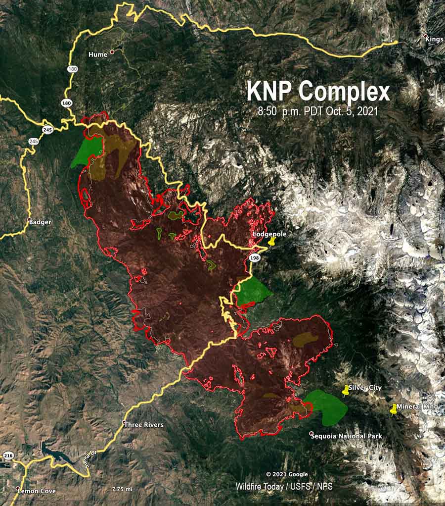
Approximately 550 acres have burned north of Generals Highway one mile southeast of the community of Wilsonia. Tuesday evening Operations Section Chief Chad Rice said hand crews and dozers are constructing line around that large slop over, tying in to old fire lines, fuel treatments, and roads where they exist. That should be complete “in a few shifts,” Mr. Rice said.
A large number of firefighters are working in Grant Grove and Wilsonia to make them easier to defend if the fire spreads into those areas.
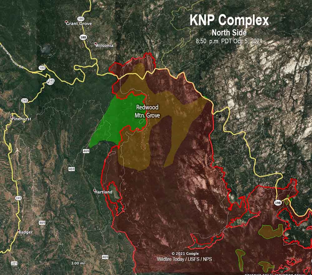
The incident management team has not released information about the mortality of the giant sequoias in the Redwood Mountain Grove after the fire spread rapidly through the area on October 4. It is the largest grove on Earth of the trees and contains the world’s tallest giant sequoia, 312 feet (95 meters). The huge trees with bark up to a foot thick are normally fire resistant and can live for more than 3,000 years old if climate change was not creating multi-year droughts and extremely low fuel moistures. Last year the Castle Fire, just to the south, destroyed an estimated 7,500 to 10,600 large sequoias with trunk diameters of more than four feet, which was 10 to 14 percent of all large sequoias across the tree’s natural range in the Sierra Nevada.
Near Stony Creek Lodge and Cabin Creek on the northeast side of the fire there is a 200-acre slop over across Generals Highway that firefighters are working on.
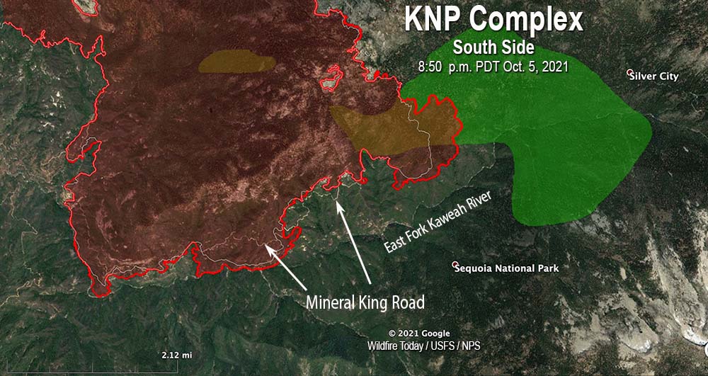
On the south side, the fire has crossed Mineral King Road in several places, which in that steep topography raises the level of difficulty in stopping the spread in that area. It has not yet crossed the East Fork of the Kaweah River, but Operations Section Chief Chad Rice said he expects it will cross to the south side. The terrain, fuels, fire behavior, and the one-lane road so far have made it unsafe for fire crews to work in some locations on the south edge of the fire, Mr. Rice said. For several hours on Tuesday a boulder the size of a car rolled down onto the road, blocking it until the boulder could be removed.
There are no reports of any residences being destroyed. Resources assigned to the fire include 38 hand crews, 111 fire engines, and 16 helicopters for a total of 1,866 personnel.
Evacuation details are available on a map and at the Tulare County Sheriff’s Facebook Page.
Lightning started two fires on September 9, the Paradise and Colony Fires, which later merged to become the KNP Complex of fires. It is burning in the Sequoia and Kings Canyon National Park and Sequoia National Forest and is being managed as a full suppression fire.

Well, at least now the SQF, SNF and KNP will have large areas of old burn to work from in the future!
A question needs to be asked, that is based on the following propositions:
1. Sequoia mortality in the groves affected may be substantial due to the nature of this fire.
2. The fire has spread to those groves, which are many miles from the fire origin, over a period of nearly a month.
3. During that month, the fire has been fought solely through the existing fire management system of the state and federal agencies.
4. As stated in prior articles, “The incident management team is having difficulty obtaining the firefighting resources they need.”
5. The park’s primary mission, on paper at least, is to “preserve unimpaired” the Sequoias.
Question: Why has the issue of protecting the groves not been elevated beyond the agencies to the level of a national concern with commensurate emergency response and/or application of significant military resources and equipment, in advance of the fire reaching the groves?
If one looks a recent fire history map of the Southern Sierra with the groves, a cumulative loss of a third or more is now easily possible just in the past decade. A self-congratulatory media narrative was quickly put out early on patting everyone on the back for saving Giant Forest, but was that not just a distraction from the facts on the ground? Curious then, how no one who should have vocally demanded more and different (read: military) resources – such as the park superintendent, scientists, activists, environmentalists – has ever gone to the national media or political branches since, as the situation has grown worse. Was no one empowered to do so? Do we have such mice running things in DC that it did not occur to them? At one time NPS had a written, pull out all the stops, call the troops in plan to save Giant Forest in the event of a severe fire – because NPS knew it would not survive as an agency if it lost the Giant Forest.
The use of extraordinary measures to protect the outlying groves is expressly authorized by the NPS’s own mission to “preserve unimpaired” the basis for the park itself. What is extraordinary is for disconnected, unaccountable, mediocre administrators in government to be so dead on the inside that they do not feel such an effort is warranted or possible, in the richest most technologically advanced country on Earth. How fitting that this grotesque loss of ancient life occurs under the nose and under the watch of the climate-woke techno-narcissists in the Golden (administrative) State.
I think of Ray Nagin in New Orleans after Katrina, compared to the current NPS administration. One chewed out the feds on live TV and got the troops he needed. The other is acting careerist and politic, staying out of the national media, and trying to control and deflect the narrative (blame climate change, blame lack of resources, suppress information about how bad the fires are in the affected groves). Instead of going along to get along, the so-called administrators and agency scientists should be rocking the boat and making demands commensurate with the need of the increasing bleak situation for the groves being decimated.
Palisades,
I am a bit confused as to what role you believe the military would play here. The military is not more skilled, specialized, or experienced in wildland fire than the agencies are. It may be easy to forget, but the U.S. Forest Service and the various DOI agencies (BLM, NPS, BIA, USFWS, etc…) are, bar none, the best in the world at both suppressing and managing wildland fires.
I have worked with military crews on fires, from both the National Guard and the Marines. They are useful due to their fitness and willingness to work, but their lack of experience and specific training in this area means they can only be used in simple situations (eg. rehab, mop up, maybe road prep if paired with sawyers). Complex situations involving firing operations, falling trees, night operations, etc… are not a good use of inexperienced firefighters.
Thanks for the article. We have a cabin near the northwestern part of the fire and your site has some of the most informative commentary about what’s actually going on.
I believe you mean it has not crossed the East Fork of the Kaweah River, which comes down from Mineral King. The Middle Fork is south of Giant Forest.
Tom, the Ops Chief called it the Middle Fork, but you’re right. It is the East Fork of the Kaweah River.
Fixed the text and the map.
Yes, that is true. If it jumps the East Fork, it will likely run into the Castle fire from last year which burned the South Fork. Which means the south end may be limited by the 2020 fire, and the north end by the 2015 Rough fire.