In a two year period 13 to 19 percent of all large sequoias in their natural range were killed by fires

If a sequoia is lucky, it can live for up to 3,000 years

burned Sequoia grove in Sequoia and Kings Canyon NP
Sequoia grove in Sequoia and Kings Canyon NP, November, 2021. NPS photo by Daniel Jeffcoach.

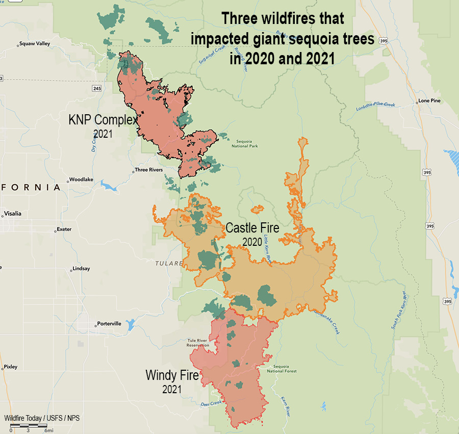
In 2020, 10 to 14 percent of the entire Sierra Nevada population of giant sequoia trees over 4 feet in diameter were killed in the Castle Fire. Early estimates expect that on two fires in 2021, the KNP Complex and the Windy Fire, 2,261 to 3,637 sequoias over four feet in diameter have already been killed or will die within the next three to five years. These losses make up an estimated additional 3-5% of the entire Sierra Nevada sequoia population over four feet in diameter.

In a two year period 13 to 19 percent of all giant sequoias in their natural range over four feet in diameter were killed or will die in the next few years.

These trees can live for up to 3,000 years. However, climate change, inadequate fuel management in the sequoia groves over previous decades, possible regeneration failure following the fires, and a shortage of firefighters while the blazes were burning have led to a significant threat to the persistence of the species.

Three Fires, giant sequoia trees
Three fires in two years that killed giant sequoia trees. The darker green areas represent groves of giant sequoias.

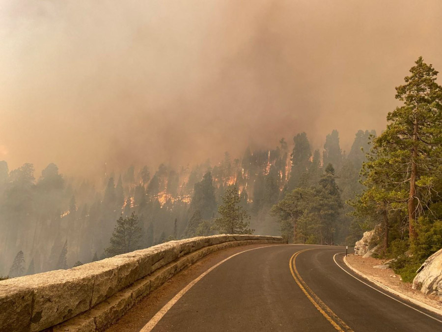
The burn severity in the 2021 fires was variable, from low severity which was beneficial, to high, which killed most of the trees and could make natural regeneration difficult or impossible. Areas that had been previously treated with prescribed fire or mechanical thinning reduced the mortality during the fires and allowed crews opportunities to safely fight fire more effectively.

Funds have been requested for the hundreds of acres, at least, that need to be replanted by hand.

Below is the “executive summary” of a report recently released about the effects of this year’s wildfires on the giant sequoia groves.


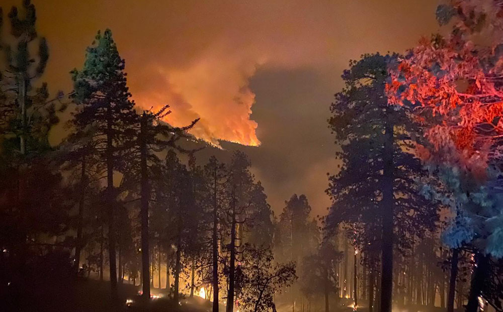
The 2021 fire season included two large wildfires (both started by the same lightning storm in early September) that burned into a large number of giant sequoia groves. This species has a limited distribution, covering just ~28,000 acres in ~70 groves on the western slopes of the Sierra Nevada mountains. Given the impacts of the 2020 Castle Fire to sequoia groves, where losses were estimated at 10-14% of the entire Sierra Nevada population of sequoia trees over 4 feet in diameter, there is significant concern by sequoia managers and the public regarding the impacts of these new fires. This report summarizes potential impacts to groves that were burned in the 2021 fire season, in the KNP Complex Fire and Windy Fire, including number of groves burned, amount of grove area burned at differing vegetation severity (RAVG-composite burn index), estimated number of large sequoias killed based on a preliminary analysis, the percentage of the entire population this loss represents, potential for regeneration failure, and potential for loss of seed source due to erosion (for KNP only). All of the data, data analysis, maps and modeling contained in this report are excerpted from the Burned Area Emergency Response Plan for the KNP Complex produced by an interagency team and submitted by the National Park Service. Some additional explanatory text and structure has been added to make this a standalone report. Because of this emphasis, there is more detail and analysis for KNP Complex sequoia groves than those burned in the Windy Fire.

Grove-level Estimates

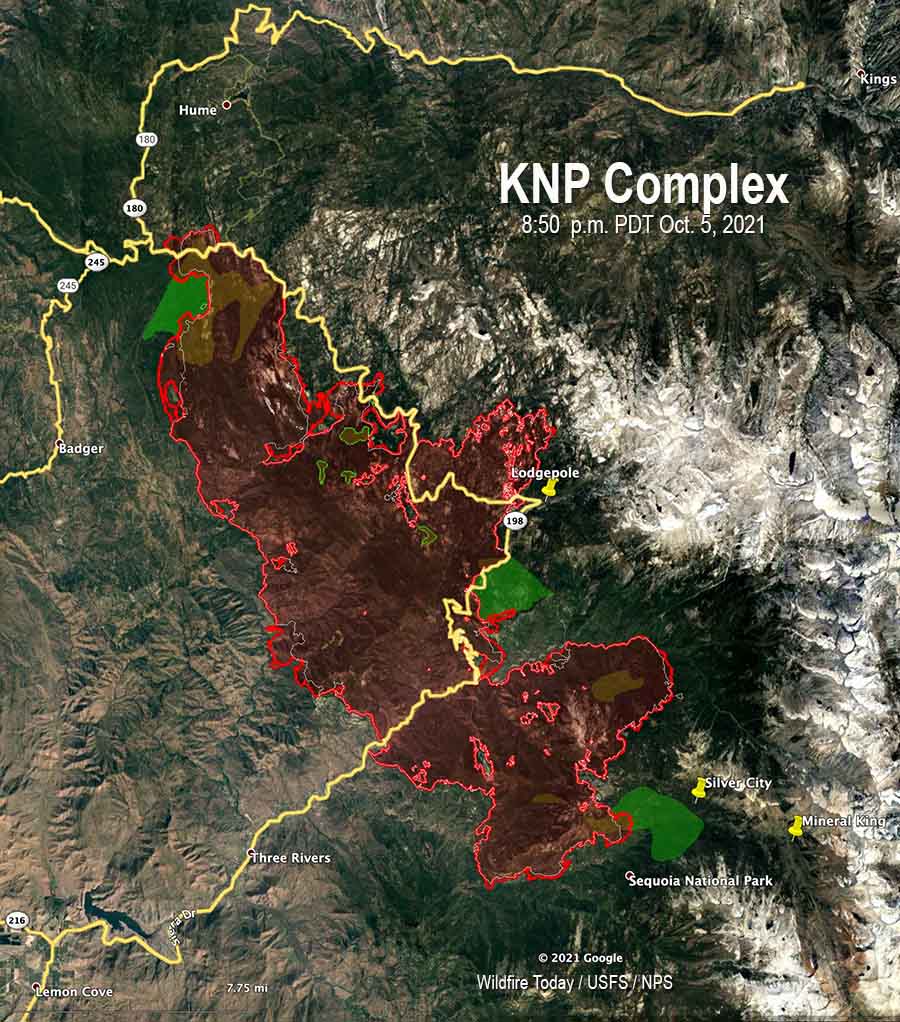
  • In total 27 sequoia groves are fully or partially within the fire perimeters of the KNP Complex Fire and the Windy Fire.
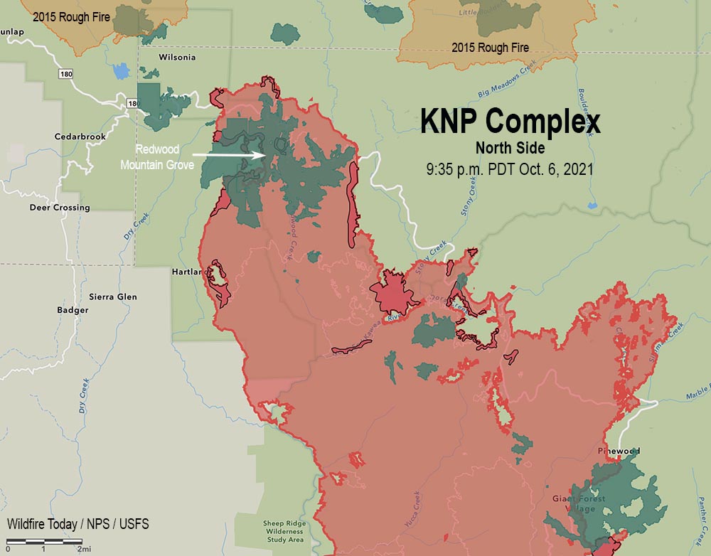
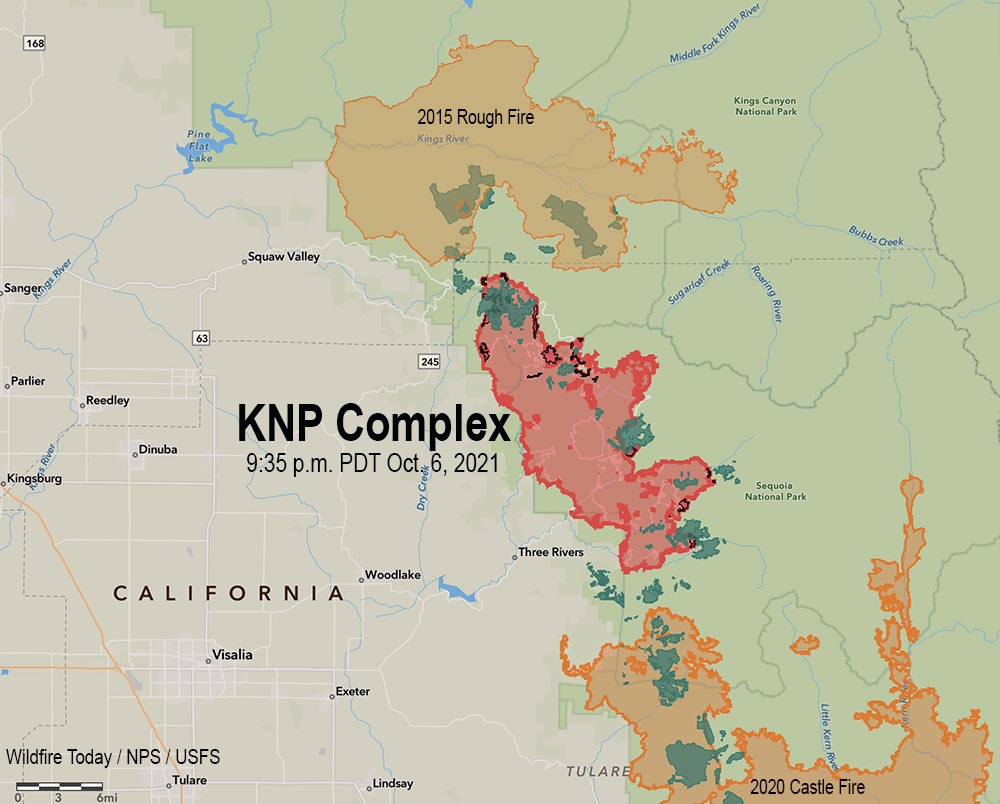
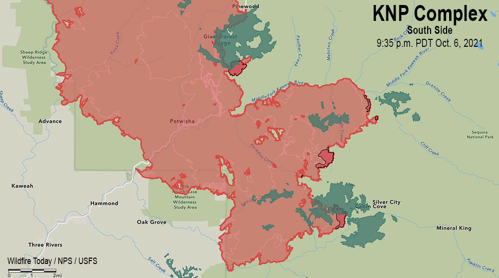
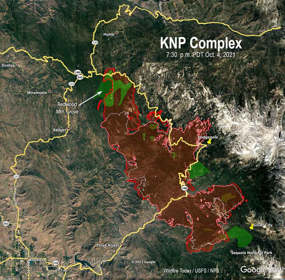
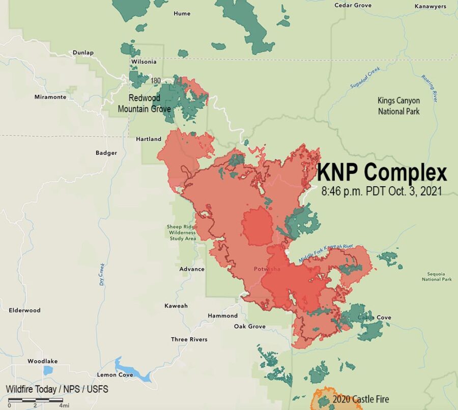
    • 16 groves burned in the KNP Complex Fire.
    • 11 groves burned in the Windy Fire.
    • For both fires combined, 6,109 acres of giant sequoia groves were burned. This estimate is based on updated grove boundaries provided by the NPS and the USFS Region 5 Remote Sensing Laboratory.
      • KNP: 4,374 acres
      • Windy: at least 1,735 acres (Note: this estimate does not include two groves on the Tule River Reservation for which there is not publicly available spatial data)

Sequoia Grove Vegetation Burn Severity Analysis Using Composite Burn Index (CBI)

Fire severity was assessed using the USFS Rapid Assessment of Vegetation Condition after Wildfire (RAVG) four class Composite Burn Index product (CBI4) (details on the severity maps can be found on the RAVG website https://fsapps.nwcg.gov/ravg/). This analysis contains four categories of vegetation change: undetected change, low, moderate, and high, where high severity has been associated with 95% tree mortality (Miller et al., 2009). The acreage burned by severity class for each fire is:

KNP Complex (all ownerships):

  • Undetected change: 1,169 acres
  • Low: 1,849 acres
  • Moderate: 740 acres
  • High: 616 acres

Windy Fire (all ownerships):

  • Undetected change: 228 acres
  • Low: 659 acres
  • Moderate: 437 acres
  • High: 411 acres

Large Sequoia Mortality Estimates

For the KNP Complex we estimate that between 1,330-2,380 sequoias over four feet in diameter have already been killed or will die within the next three to five years. This estimate is based on RAVG satellite analysis combined with mortality rates from surveys in other sequoia groves that burned in three previous fires (similar methodology to Stephenson and Brigham 2021).

For the Windy Fire, we estimate that between 931-1,257 sequoias over four feet in diameter have already been killed or will die within the next three to five years.

The combined impact of these two fires is estimated to be 2,261-3,637 sequoias over four feet in diameter that have already been killed or will die within the next three to five years. These losses make up an estimated 3-5% of the entire Sierra Nevada sequoia population over four feet in diameter. On top of the 10-14% of large sequoias lost in the 2020 Castle fire, these fire impacts represent a significant threat to large sequoia persistence.

Dead sequoias killed fire
Dead sequoias, November, 2021. NPS photo.

Potential for Regeneration Failure

The least understood impacts of these wildfires are impacts to sequoia regeneration in high severity areas. Sequoias generally regenerate well after wildfire, though reports of inadequate regeneration in high severity areas are raising concerns. Regeneration failures could potentially occur if the cones and/or seeds were incinerated during crown fire, seeds did not survive the smoldering fire, or seeds washed away due to surface erosion. In these cases, regeneration would be dependent on proximity to live tree seed sources.

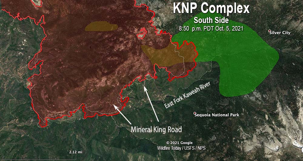
For the KNP complex we analyzed high severity areas within sequoia groves that were over 100 meters from an intact sequoia grove area with live sequoia trees (represented by areas of undetected change, low or moderate severity). In total 436 acres were identified that may be vulnerable to total sequoia loss if regeneration from seeds that survived the fire is inadequate. Of the 436 acres >100m from live sequoia forests, 335 acres are on NPS lands. The Burned Area Rehabilitation Plan recommends reforesting these 350 acres with giant sequoias if adequate regeneration is not present based on subsequent field surveys.

Erosion modeling suggests that the high severity areas identified for potential restoration are also at high risk of losing any seeds that did survive the fire due to surface erosion.

Other Key Points

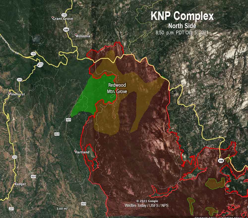
In several places that burned during this event, previous prescribed fire work appears to have reduced fire severity (portions of Redwood Mountain Grove, Giant Forest). In other areas previous prescribed fire and mechanical thinning treatments, as well as preparation for upcoming burn units, allowed fire crews opportunities to safely fight fire more effectively (prescribed burn preparations at Lost Grove and Park Ridge Fire Lookout area were used during suppression operations on the KNP complex).

Although we are seeing some significant high and moderate severity areas in sequoia groves where we expect impacts to large giant sequoias to be detrimental, much of the grove area in the KNP Complex burned at low severity and we expect beneficial results for giant sequoias in these areas. These beneficial effects include fuel reduction, small canopy openings ideal for regeneration, and removal of litter and generation of ash – also ideal conditions for giant sequoia seedlings.

Other areas not classified as high severity may have also had beneficial effects, but the effects will likely be more mixed. In areas classified as “undetected change,” there will likely be a mix of completely unburned areas and areas that had a light surface fire that is similar to low severity fire effects. The fire effects in moderate severity will be the most variable, with some areas having beneficial effects and others being more severe.

Thanks and a tip of the hat go out to Ben.

Falling tree on KNP Complex injures four firefighters

Incident Management Team said hundreds of giant sequoia trees have likely been killed in the fire, then revised their statement

11:47 a.m. PDT Oct. 8, 2021

KNP Complex of fires map, north side
KNP Complex of fires map, north side, at 9:35 p.m. Oct. 6, 2021. The green areas represent groves of giant sequoia trees. The dark red areas showed extreme heat during the mapping flight.

Four firefighters were injured by a falling tree Thursday afternoon on the KNP Complex of fires in Southern California. The Sequoia and Kings Canyon National Parks announced Thursday night that the tree struck the firefighters who were then brought to a helispot and flown to area hospitals. The injuries were serious, the Park Service said, but the personnel were all in “stable condition.” Friday morning the agency said all four had been released from the hospitals. One is an employee with CAL FIRE and three are with the California Conservation Corps.

KNP Complex of fires map, south side
KNP Complex of fires map at 9:35 p.m. Oct. 6, 2021. The green areas represent groves of giant sequoia trees. The dark red areas showed extreme heat during the mapping flight.

Tuesday, October 5, the Sequoia and Kings Canyon National Parks wrote on Facebook that hundreds of giant sequoias may have been killed in the KNP Complex of fires:

Regarding the trees, there are some groves in the park that we suspect burned at high enough intensity to result in sequoia mortality, possibly for significant numbers of trees (hundreds). However, we are currently focused on prioritization and treatment of groves that are threatened and outside the current fire footprint, as well as mopping up trees that need it. It is not safe right now, nor is it our current priority to fully assess groves that have burned. These groves will be fully assessed from the ground by resource managers when it is possible, but that will be after the fire is basically out cold and conditions allow them to get in there – likely in 2022.

On Friday morning, October 8, that October 5 statement was edited, removing the estimate of trees that may have been killed, and softening the language about assessment of giant sequoia mortality not being a priority.

We suspect that some groves in the park burned at high enough intensity to cause tree mortality. We don’t know yet the extent of the fire behavior or tree mortality. We will gain what knowledge we can with aerial reconnaissance, as smoke conditions allow. These groves will be fully assessed from the ground by resource managers when it is possible, but that will be after the fire is basically out cold and conditions allow them to get in there – likely 2022.

Dozens of media outlets reported on the “hundreds” number before it was removed.

The huge 85,952-acre fire has been divided into two zones and will be managed by two Type 1 Incident Management Teams. California Interagency Incident Management Team 2 (CIIMT2) assumed command of the North Zone Thursday at 6 pm. while the Southwest Area Incident Management Team 2 remains in command of the South Zone.

KNP Complex of fires map, south side
KNP Complex of fires map, south side, at 9:35 p.m. Oct. 6, 2021. The green areas represent groves of giant sequoia trees. The dark red areas showed extreme heat during the mapping flight.

Friday morning several weather stations in the general vicinity of the KNP Complex recorded less than 0.05 inch of precipitation by 10:15 a.m. PDT. More is in the forecast during the day on Friday possibly amounting to a wetting rain of a quarter of an inch or more over the northern portions of the fire. Lesser amounts of 0.10 to 0.15 inch are likely to the south in the Mineral King and Case Mountain areas.  This is not expected to be enough to put out the fire, but it is likely to slow it down for at least several days. The forecast for Saturday and Sunday is for high temperatures in the 40s and 50s depending on the elevation, with very high humidities lowering into the 30s by Sunday. There is another chance for rain on Monday along with humidity in the 50s and 60s. Tuesday and Wednesday will be sunny with humidities of 25  to 40 percent. The wind will be generally moderate throughout this period.

All this adds up to reduced growth through Tuesday, providing opportunities for firefighters to construct direct firelines.

On the north zone Friday the primary focus will be the area where the fire crossed the Generals Highway south of Grant Grove. Thursday night a tactical firing operation from Park Ridge to Redwood Canyon secured that portion of the line. An indirect line is being constructed around Stony Creek Lodge to the Generals Highway. Increased humidity and shading of fuels by clouds will decrease fire behavior Friday and provide more opportunities to build direct line.

On the south zone, heavy equipment and crews are implementing structure protection actions around Case Mountain Grove, Silver City, and Mineral King. Fire spread south of Mineral King Road is being reduced with line construction and hose lays in place.

Evacuation ORDERS and WARNINGS are still in place.

Fire crosses Generals Highway on the KNP Complex of Fires
Fire crosses Generals Highway on the KNP Complex of Fires. Posted Oct. 6, 2021. InciWeb.

Firefighters on the KNP Complex of fires working to contain slop overs across Generals Highway

The fire in Sequoia National Park has burned more than 81,000 acres in California

8:03 a.m. PDT Oct. 6, 2021

KNP Complex of fires, near Eshom
KNP Complex of fires, near Eshom Campground, Oct. 4, 2021. InciWeb.

On the KNP Complex of fires in Sequoia National Park in Southern California, the smoke, which has limited the use of firefighting aircraft for days or weeks, cleared by mid-morning Tuesday more than it had in recent days which allowed the use of some aviation resources both on the north and south ends of the fire. An increase in relative humidity has slowed the spread for the last two days, allowing firefighters to construct direct fire line near the fire’s edge where conditions permit.

The blaze was mapped Tuesday evening at 81,473 acres, an increase of more than 20,000 acres in the previous 48 hours.

KNP Complex map, 8:50 p.m. Oct. 5, 2021. The white line was the perimeter on the evening of Oct. 4. The green areas are the APPROXIMATE locations of groves of giant sequoia trees.

Approximately 550 acres have burned north of Generals Highway one mile southeast of the community of Wilsonia. Tuesday evening Operations Section Chief Chad Rice said hand crews and dozers are constructing line around that large slop over, tying in to old fire lines, fuel treatments, and roads where they exist. That should be complete “in a few shifts,” Mr. Rice said.

A large number of firefighters are working in Grant Grove and Wilsonia to make them easier to defend if the fire spreads into those areas.

KNP Complex map, north side
KNP Complex map, north side, 8:50 p.m. Oct. 5, 2021. The white line was the perimeter on the evening of Oct. 4. The green areas are the APPROXIMATE locations of groves of giant sequoia trees.

The incident management team has not released information about the mortality of the giant sequoias in the Redwood Mountain Grove after the fire spread rapidly through the area on October 4. It is the largest grove on Earth of the trees and contains the world’s tallest giant sequoia, 312 feet (95 meters). The huge trees with bark up to a foot thick are normally fire resistant and can live for more than 3,000 years old if climate change was not creating multi-year droughts and extremely low fuel moistures. Last year the Castle Fire, just to the south, destroyed an estimated 7,500 to 10,600 large sequoias with trunk diameters of more than four feet, which was 10 to 14 percent of all large sequoias across the tree’s natural range in the Sierra Nevada.

Near Stony Creek Lodge and Cabin Creek on the northeast side of the fire there is a 200-acre slop over across Generals Highway that firefighters are working on.

On the south side, the fire has crossed Mineral King Road in several places, which in that steep topography raises the level of difficulty in stopping the spread in that area. It has not yet crossed the East Fork of the Kaweah River, but Operations Section Chief Chad Rice said he expects it will cross to the south side. The terrain, fuels, fire behavior, and the one-lane road so far have made it unsafe for fire crews to work in some locations on the south edge of the fire, Mr. Rice said. For several hours on Tuesday a boulder the size of a car rolled down onto the road, blocking it until the boulder could be removed.

KNP Complex map, south side
KNP Complex map, south side, 8:50 p.m. Oct. 5, 2021. The white line was the perimeter on the evening of Oct. 4. The green areas are the APPROXIMATE locations of groves of giant sequoia trees.

There are no reports of any residences being destroyed. Resources assigned to the fire include 38 hand crews, 111 fire engines, and 16 helicopters for a total of 1,866 personnel.

Evacuation details are available on a map and at the  Tulare County Sheriff’s Facebook Page.

Lightning started two fires on September 9, the Paradise and Colony Fires, which later merged to become the KNP Complex of fires. It is burning in the Sequoia and Kings Canyon National Park and Sequoia National Forest and is being managed as a full suppression fire.

KNP Complex of fires crosses Generals Highway east of Wilsonia, California

Burns most of the Redwood Mountain Grove, the largest grove of giant sequoia trees on earth.

 1:30 p.m. PDT Oct. 5, 2021

KNP Complex map north side Wilsonia
KNP Complex map, north side. The red line was the perimeter at 7:30 p.m. Oct. 4, 2021. The green areas are the APPROXIMATE locations of groves of giant sequoias.

On Monday the KNP Complex of fires in Sequoia National Park, pushed by 55 mph winds, crossed Generals Highway about a mile east of Wilsonia. The extreme fire behavior forced firefighters to temporarily move to safer locations. The additional growth resulted in the fire becoming well established in Redwood Creek and burning much of the Redwood Mountain Grove, which is the largest grove of giant sequoia (Sequoiadendron giganteum) trees on earth. It contains the world’s tallest giant sequoia, 312 feet (95 meters). The amount of mortality of the sequoias is unknown at this point.

At least two very large pyrocumulus convection columns of smoke were seen Monday on the north side of the fire that rose to more than 32,000 feet, indicating extreme fire behavior.

This additional growth threatens Hartland, Quail Flat, Wilsonia, and Grant Grove. Firefighters are doing what they can to provide structure protection in these locations.

KNP Complex map
KNP Complex map. The red line was the perimeter at 7:30 p.m. Oct. 4, 2021. The white line was the perimeter about 48 hours before. The green areas are the APPROXIMATE locations of groves of giant sequoias.

The KNP Complex has burned 79,382 acres. Resources assigned include 27 hand crews, 90 engines, 35 water tenders, 18 dozers, and 13 helicopters for a total of 1,566 personnel.

On the southern side of the fire Monday, firefighters worked along Mineral King Road to contain the spot fires from Sunday night. They also provided structure protection in Silver City and the Mineral King area. Helicopters were able to support ground resources with bucket drops on Monday after the smoke cleared enough to safely fly.

On Tuesday crews are working on control lines to keep the fire out of the communities near the Redwood Mountain Grove on the north side of the blaze.

KNP Complex of fires
KNP Complex of fires. Uploaded to InciWeb Oct 4, 2021.

Large firing operations underway on KNP Complex of fires

Sequoia National Park in California

4:13 p.m. PDT October 4, 2021

The firing operation on the north side of the KNP Complex along the Generals Highway/180 southeast of Wilsonia is moving along rapidly. It appears to have begun on Saturday, and by the time of the mapping flight Sunday night had spread half a mile to a mile south of the highway. It is now moving through the Redwood Mountain Grove, which is the largest grove of giant sequoia (Sequoiadendron giganteum) trees on earth. It contains the world’s tallest giant sequoia, 312 feet (95 meters).

Monday morning @mn_storm reported that a very large pyrocumulus convection column of smoke had been created that rose to 33,000 feet where the temperature reached -62°F. Monday afternoon @mm_storm said another pyrocumulus had reached 40,000 feet.

Nate Bogenschutz, an information officer for the fire, told Wildfire Today at 4 p.m. PDT Monday that the firing operation had remained within it’s intended boundaries and had not crossed Generals Highway/180. He said fire activity had increased around most of the fire today.

Our hope is that most of the smoke is not coming from the Redwood Mountain Grove and the tactical firing operation, and that the operation does not destroy large numbers of giant sequoia trees, which can live for more than 3,000 years old if climate change was not creating multi-year droughts and extremely low fuel moistures.


10:27 a.m. PDT Oct. 4, 2021

Map of the KNP Complex of fires
Map of the KNP Complex of fires, 8:46 p.m. Oct. 3, 2021. The dark red line was the perimeter on October 1. The green areas are groves of sequoia or redwood trees.

A drying trend over the last several days has led to an increase in fire behavior on the KNP Complex of fires in the Sequoia National Park in California. This has been especially apparent in lower elevations on the south and west sides where brush is the primary component of the vegetation.

Smoke trapped under an inversion has socked in the drainages and has limited the use of conventional aircraft for the last few days. However drones with infrared technology which can see through smoke have been flying, providing intelligence about the spread of the fire.

Map of the KNP Complex of fires
Map of the north side of the KNP Complex of fires, 8:46 p.m. Oct. 3, 2021, showing two firing operations. The dark red line was the perimeter on October 1. The green areas are groves of sequoia or redwood trees.

Two large firing operations are ongoing. On the north side near the Heartland community firefighters are working to keep the fire in Redwood Canyon, an area that is very steep and rugged all the way north to the Redwood Mountain Grove and the Generals Highway/180. The canyon is too steep and inaccessible and has multiple hazards, making it unsafe for firefighters. Saturday night a firing operation began at the highway to get the fire to back down the slope to the south, creating a buffer along the highway. By Sunday night fire personnel had ignited along four miles of the highway.

A few miles to the southeast, another firing operation is working north along the Generals Highway, starting near Dorst Campground. After it proceeds for a few miles, it will leave the highway to get onto a trail system to the west, closer to the fire, and will eventually meet up with the other operation which is working south off the highway.

KNP Complex of fires, Inyo Hotshots,
KNP Complex of fires, Inyo Hotshots, Sept 29, 2021. InciWeb.

The incident management team is having difficulty obtaining the firefighting resources they need. This is due to several reasons, including the fact that some seasonal employees on hand and engine crews are reaching the end of their employment periods, and other fires are competing for the same types of resources.

Sunday night strong winds on the south side of the fire caused a spot fire across Mineral King Road which prompted an evacuation order for Crest, Sierra King, Hammond, and Oak Grove. Evacuation details are available on a map and at the  Tulare County Sheriff’s Facebook Page.

Repeater installation KNP Complex of fires
Helicopter waits for technicians installing a radio repeater on the KNP Complex of fires, Oct. 2, 2021. InciWeb.

KNP Complex of fires approaches 50,000 acres

1:30 p.m. PDT Sept. 30, 2021

KNP Complex of fires
KNP Complex of fires, posted Sept. 28, 2021 by IMT.

The KNP Complex of fires in Sequoia National Park in Southern California has grown to 49,349 acres.

In a Thursday morning briefing Operations Section Chief Trainee Clint Remington said the fire on the south side of the Middle Fork is backing down closer to the bottom of the drainage. If it crosses, it could run uphill toward the Giant Forest, one of the larger groves of giant sequoia trees in the park. Firefighters have spent weeks prepping this and other groves, removing fuels, clearing around structures, and installing hose lays.

The fireline between the Giant Forest and Lodgepole has received a lot of attention in recent days and is considered secure and contained, but there is a lot of work left to do on the northwest side of the fire, northwest of Red Fir and west of the Generals Highway.

The west side of the fire where it has moved into lighter fuels, including brush, is looking good, Mr. Remington said.

KNP Complex of fires map
KNP Complex of fires map, 1:30 a.m. PDT Sept. 30, 2021. By Incident Management Team.