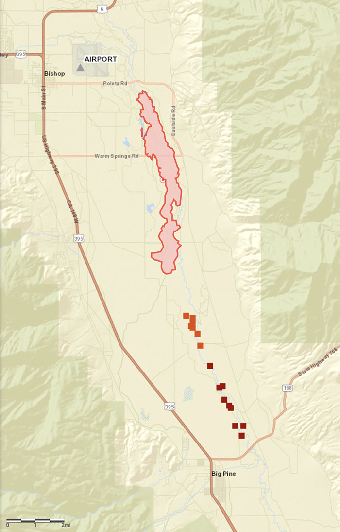
Updated 2:17 p.m. PT Feb. 17, 2022

The growth of the Airport Fire slowed substantially by mid-day Thursday, judging from photos taken in the morning and afternoon. There are still a few residual smokes showing in the image shot by the camera on Marzano Peak at 1:56 p.m., but no dark gray columns.

Caltech, the operator of the Owens Valley Radio Observatory, said that as of Thursday morning at 11 a.m. personnel were reporting that a perimeter had been established around buildings and the main threat to the structures had passed. Assessment of instrumentation and antennas in the field surrounding the main facility structures, however, was ongoing.
The #AirportFire in California’s Eastern Sierra near the town of Big Pine is currently 3900 acres, 0% contained, and threatening the area near the Owens Valley Radio Observatory, a place near and dear to my heart. ? pic.twitter.com/BesGIxVrr5
— Absorbing Photons ? (@brianfulda) February 17, 2022
CAL FIRE said at 9:53 a.m. Thursday that the Airport Fire had burned 3,900 acres.
Updated 9:47 a.m. PT Feb. 17, 2022

The map of the Airport Fire above is more accurate than our earlier map.
9:10 a.m. PT Feb. 17, 2022

The Airport Fire was very active Wednesday night. When the sun rose Thursday it spanned for about 13 miles from the airport in Bishop, California south to Big Pine. CAL FIRE reports that evacuations have been ordered for properties in Big Pine that are east of US Highway 395. The town has a population of about 1,500.
(To see all articles on Wildfire Today including the most recent, click https://wildfiretoday.com/tag/airport-fire/)
CAL TRANS closed Highway 168 from the junction of 395 in Big Pine to Death Valley Road.
CAL FIRE said at 7 a.m. Thursday it had burned 2,800 acres as it spread south through the Owens Valley.
The photo in the tweet below which was taken from Big Pine was posted at 7:05 a.m. Thursday.
#AirportFire near Big Pine California. Taken from @Coppertopbbq pic.twitter.com/wojtrka6Bv
— Eastern Sierra Now (@owensvalleynews) February 17, 2022
CAL FIRE dispatched six S-2 air tankers Thursday at about 8 a.m.
Areas that are threatened include two research facilities, White Mountain Research Center and Owens Valley (Caltech) Radio Observatory. Both were evacuated Wednesday.
The blaze started Wednesday afternoon near the Eastern Sierra Regional Airport at Bishop.
Photos taken from Marzano Peak early Thursday morning showed active fire near Big Pine. In the southernmost area of the fire dense, dark smoke was visible which could indicate heavy fuels, such as structures or vehicles burning.


The wind, which on Wednesday was out of the north at 28 mph gusting up to 50 mph, slowed during the night but was still strong, 15 to 22 mph gusting at 26 to 32 mph with the relative humidity in the mid-30s. At 8:20 a.m. Thursday the Big Pine weather station recorded 15 mph north-northwest winds gusting to 21 mph while the relative humidity was 40 percent.
The forecast for Big Pine on Thursday is for 56 degrees, 16 percent relative humidity in the afternoon, and 10 to 14 mph winds out of the northwest gusting until noon at 20 mph. These conditions will be conducive to active spreading of the fire, as long as the fuel is continuous.
Resources assigned to the fire Thursday morning include 66 fire engines, 7 water tenders, 1 helicopter, 16 hand crews, and 7 dozers for a total of 432 personnel.

’22 may be an interesting ride…