
Updated at 6:51 a.m. MDT June 20, 2022
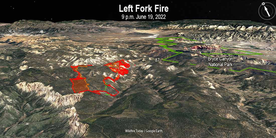
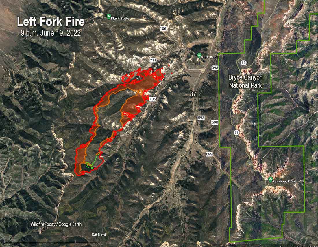
The Left Fork fire continued to spread to the northeast Sunday night in the Dixie National Forest in Southern Utah. When it was mapped at 9 p.m. Sunday it had burned approximately 2,600 acres. At that time it was about 2 miles west of the 87 road and Bryce Canyon National Park.
9:50 p.m. MDT June 19, 2022

The Left Fork Fire in Southwest Utah has taken off again after being dormant for about a month on the Dixie National Forest. It was first detected May 9. On May 10 the Forest Service said it ignited from material still burning from a prescribed fire conducted April 7, 2022. On May 11, 12, and 13 the daily updates about the wildfire posted by the Forest Service stated it was “human caused.” The escaped fire burned 97 acres in early May.
Apparently undetected smouldering material on or under the ground, such as stumps, duff, or tree roots, must have continued burning for weeks after the prescribed fire, and later after the spread of the 97-acre wildfire was stopped. Follow up monitoring of both events either did not occur or was inadequate to detect the still burning fires. The strong winds on June 18 may have fanned it back into an active burning condition, and it spread across a fireline, or hot embers were blown outside the perimeter into receptive fuels.
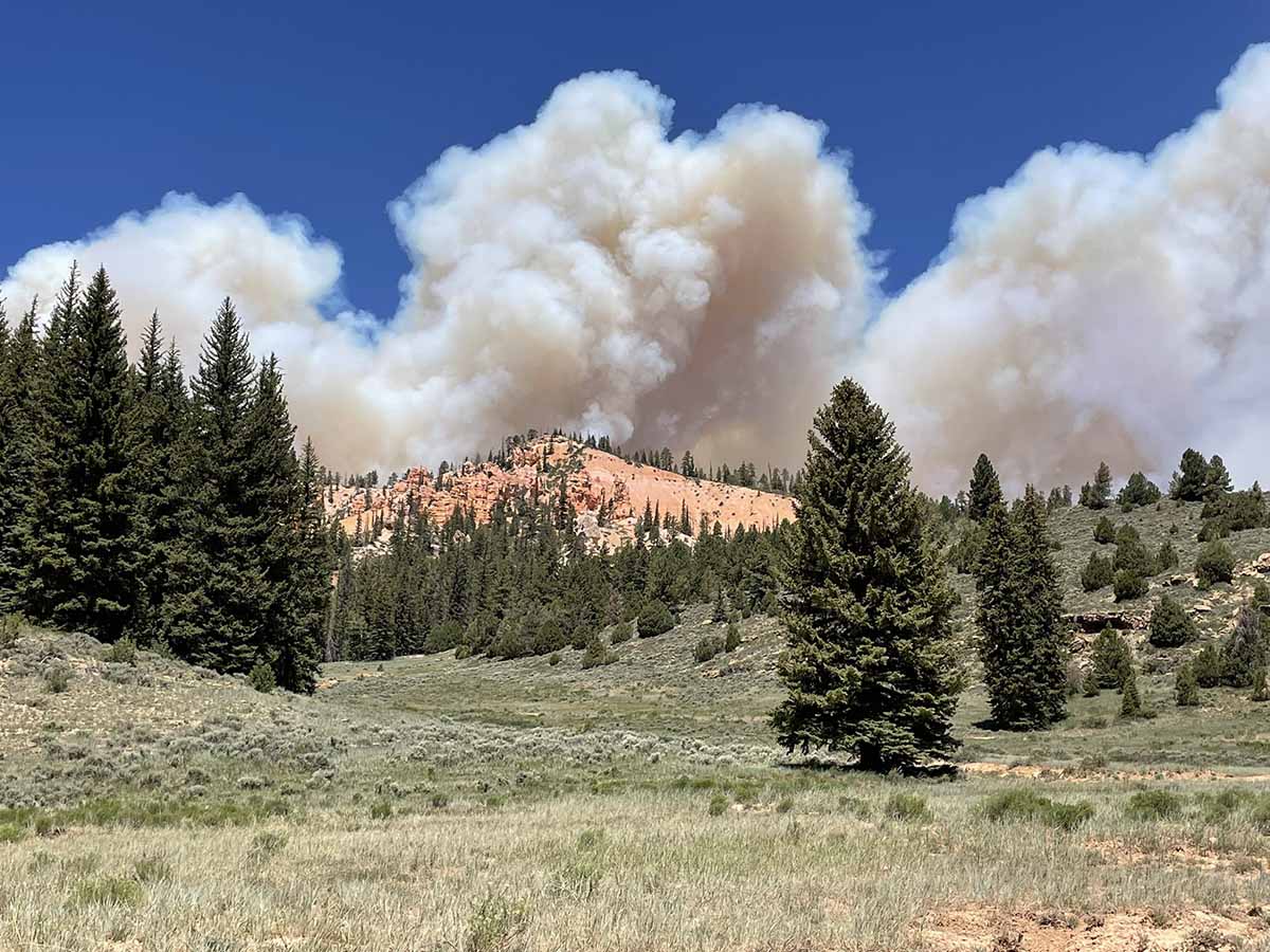
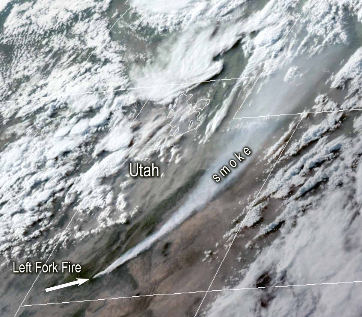
On June 18 the fire began spreading again pushed by strong winds. Utah Fire Information said that day it was estimated at 300 to 500 acres. Sunday afternoon, June 19, it had grown to 600 to 700 acres in rugged terrain, putting up a huge smoke plume affecting the air quality in eastern Utah and southwest Colorado.
The original cause of the fire is still listed as “human caused.” There are dozens of ignition sources that cause wildland fires. Saying it is caused by humans only eliminates two — volcano and lightning — and both could be ruled out very quickly.
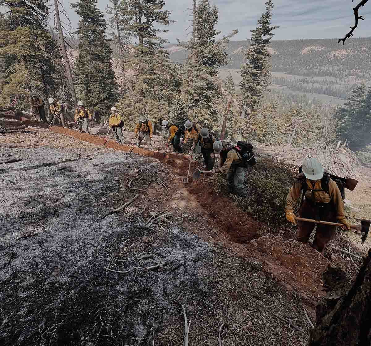
Sunday afternoon the Left Fork Fire was spreading to the northeast and was about 2 miles west of Bryce Canyon National Park, 7 miles east of Highway 89, and 20 miles south of Panguitch; it had reached Blubber Creek drainage. It is burning between 8,000 and 9,000 feet above sea level.
The area was under a Red Flag Warning Sunday for relative humidity in the teens and 20 mph southwest winds gusting at 35 to 40 mph. The strong winds kept helicopters and fixed wing aircraft grounded, unable to assist firefighters on the ground.
The NWS spot weather for Monday calls for 70-72 degrees, 10-12 percent relative humidity, and 5 to 15 mph winds out of the west shifting to southwest. Tuesday will be about the same except the wind will be out of the southeast at 10-20 mph in the afternoon.
A Color Country Type 3 Incident Management Team will assume command of the incident Sunday evening.
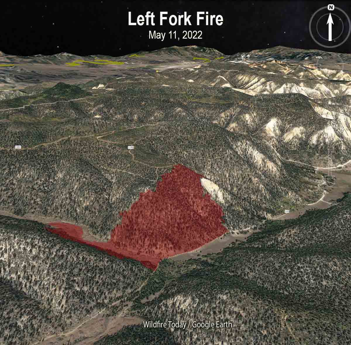
The map below shows the location of the Left Fork Fire after the spread was temporarily stopped around May 11, 2022.
About a week after the first attempted suppression of the Left Fork Fire the US Forest Service announced May 20 in a press release that a “pause” was in effect for all prescribed fire operations on National Forest System lands. The reason given was “because of the current extreme wildfire risk conditions in the field…while we conduct a 90-day review of protocols, decision support tools, and practices ahead of planned operations this fall,” Forest Service Chief Randy Moore said in the statement. At the time several other prescribed fires had recently escaped in addition to the Left Fork incident.

We have all felt the pressure to get acres treated, well those of us that are in management positions, RXB2’s and such, and at times we are pushed into making decisions we do not like, I allowed myself to be pushed into a decision that was regretted by many, I never allowed myself to be pushed again, EVER!
USFS UT has had a few maybe more escapes near as I can tell, there is something very recent, just do not recall the details.
I am not comfortable with the term dormant, this is another example of a RX that was lit then put out, came out and then suppressed and a month later here we are….A team or not……this is not acceptable.
To me dormant describes a fire that has not been detected yet….ie hold over lighting….I know……it’s just my opinion…
It’s one thing to ignite your RX only to have it escape right in front of you, but it’s another thing to have it bite you months later…..This is all to frequent…..maybe it’s time to bring RXB’s in for some much needed remedial training…..Just saying…..A pause may not get it….it would be good to have an independent group take a look at things and maybe offer a fresh perspective on RX operations….
No telling how much the tax payers will be on the hook for the NM escapes, I would wager it will make Cerro Grande look like discarded pennies….It’s going to be BIG!
We all make mistakes, but when it becomes systemic we then have a real problem with credibility….Maybe I am way off base.
My intent is to never make it personal……
Really!?
Their wilderness fires are left unattended for weeks before they rage out to burn homes (see Tamarack 2021). Their Rx fires escape to threaten/burn communities. And fires that have been mopped up come to life and jump fire lines… nearly a month later!!
Is it complacency?
Is it bad luck?
Is it incompetence?
It sure isn’t wildland fire control.
Well Bruce, when you have fuel/fire conditions like we currently have you NEED really, really experienced people on the fireline. Unfortunately, all of those people are leaving because the FS blows. Now, you have 3rd stringers out there in 1st string conditions and they’re being shutout.
The incompetence displayed by the US Forest Service continues to amaze me. Prescribed burn after prescribed burn escaping to become wildfires, some of them indisputable tragedies as in New Mexico. Aggressive initial attack not widespread anymore, let burn fires that are actioned at great expense after they eventually become problematic, insufficient air tanker numbers, and as I have become aware on this site, and personnel management that has a large number of employees leaving the service. It’s past time to initiate a plan to relieve the agency of its fire responsibilities and create one Federal professional fire agency, one that is accountable for its outcomes (or in a positive note, recognized for a positive turnaround). Maybe then they could concentrate on real forest management that utilizes our National timber resources sustainably through harvest.
You’re tracking pretty good Leidholm. The FS is a rapidly sinking ship, upper mgmt is filled to the gunwales with keyboard land managers that are telling the people that are ACTUALLY on the ground how and what to do.
I agree with everything except your last sentence. The vast majority of FS timer has no real value, especially in the west where it is mainly bug kill. The FS actually has to PAY logging contractors to even enter a unit. Almost every acre of FS lands are eligible to be logged/thinned and many units are already laid out and available for bidding…but nobody bids because the timber is junk.
CYA has long been with us. I agree with Bill’s assessment. Having been assigned to mop-up operations, I have see huge, man-sized hellfire holes where the roots of giant (>10 feet dbh) trees had been logged that could have glowed for months. I can see where glowing roots could burn very slowly underground into unburned material. Five gallon backpacks are a joke when it comes to glowing or internally burning heavy slash and waste timber. Piling up heavy materials would seem questionable. Heavy live materials don’t burn in the initial flame front anyway. Time to break out heat sensors?
Nice work, Randy! ?
Type 3 Team? Complexity Analyses are subjective, I guess, based on decisions by Agency Administrators lately. I think the CIMT concept should be implemented widespread, allowing for one team to manage an incident from start to finish. Save money, more efficient, maintain continuity throughout the duration of the incident, no matter how complex.
I thought that’s what NIMO teams are for?
https://www.wbaltv.com/article/winds-fan-wildfire-new-jersey/40346312#
Will this 2000 acre fire morph into the threat predicted in a Rolling Stone magazine article about 6 years ago ?
Afternoon winds are 9/17 miles per hour, from the Northwest.
https://www.rollingstone.com/politics/politics-news/will-americas-worst-wildfire-disaster-happen-in-new-jersey-34156/