
Updated 5:08 p.m. PDT July 11, 2022
Late Monday afternoon activity on the Washburn Fire increased substantially. There have been reports of at least one spot fire on the north side of the South Fork of the Merced River. There were also reports of spot fires across highway 41 on the west or northwest side of the fire.
Satellite heat detections at 2:36 p.m. Monday showed numerous heat sources east of the earlier perimeter of the fire across the park boundary on the Sierra National Forest, and on the northwest side of the fire between Highway 41 and the river.
In mid-afternoon the FIRIS aircraft mapped the fire at 2,720 acres.

Updated 7:11 a.m. PDT July 11, 2022
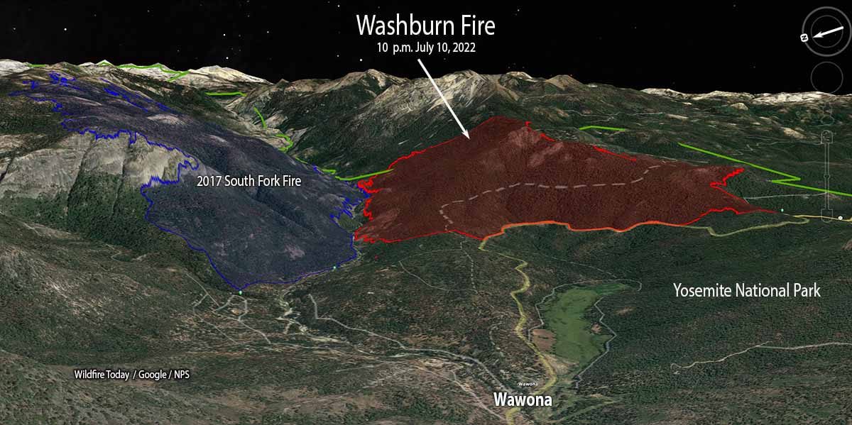
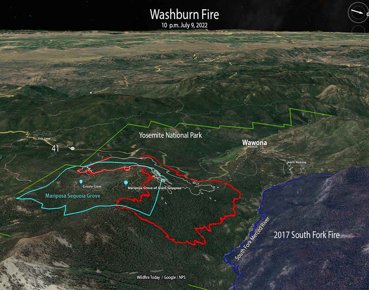
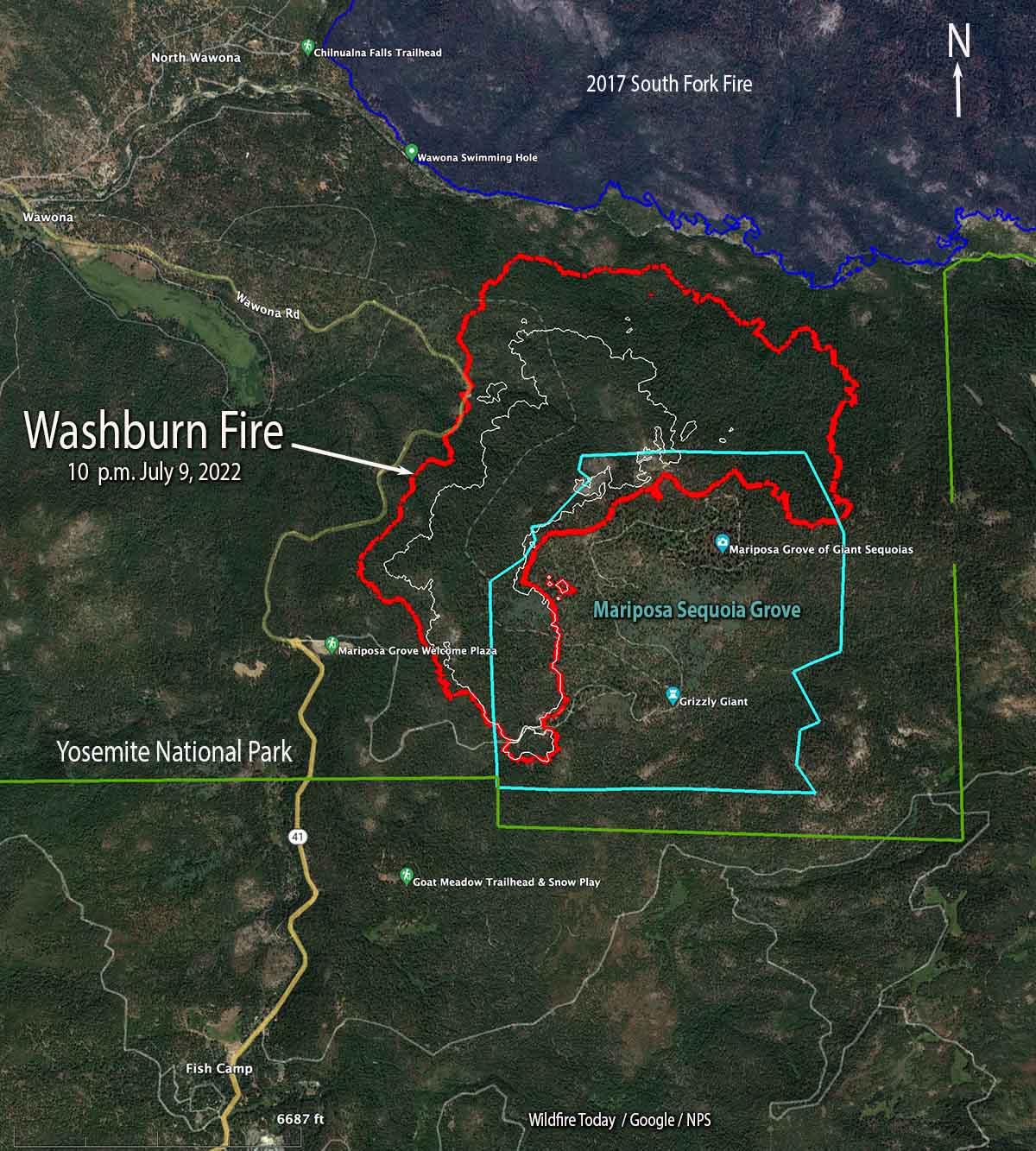
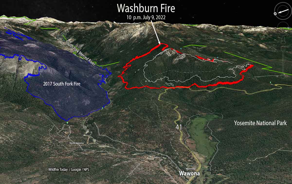
The Washburn Fire in Yosemite National Park in California continued to spread west, north, and east on Sunday. On Saturday and Sunday the size increased by 749 acres, bringing the total to 2,340 acres according to a mapping flight Sunday at 10 p.m.
Approximately 340 acres of the fire are within the Mariposa Grove of giant sequoias. While protective foil-based structure wrap is not being used on the sequoias themselves, additional methods are being employed including the removal of fuels around the trees, and ground-based sprinkler systems to increase humidity and fuel moisture near the sequoias. The Mariposa Grove has a long history of prescribed burning and studies have shown that these efforts reduce the impacts of high-severity fire.

Firefighters are constructing direct fireline on the fire edge where possible, but are also using tactical firing to tie it in with barriers, such as Highway 41 on the west side.
Evacuations are in effect in the Wawona area. A map is available showing the locations. The Wawona Road (Highway 41) is closed from the South Entrance to Henness Ridge Road. Yosemite West remains accessible from the northern side of the Wawona road.

The weather forecast for the fire area (6,400 feet above sea level) predicts for Monday and Tuesday 81 degrees, 3 to 8 mph west and southwest winds, relative humidity in the low to mid-20s, partly cloudy skies, and no chance of rain.
Updated 5:34 p.m. PDT July 10, 2022
The Washburn Fire, part of which is burning in a grove of giant sequoias in Yosemite National Park, has grown to 2,045 acres, according to a mapping flight at about 4 p.m. Saturday. Most of the additional acres are on the north and east sides. It spread closer to the South Fork of the Merced River, but at that time had not crossed. The east side has moved across the county line, from Mariposa into Madera county.

Three large air tankers and a very large air tanker dropped retardant along a ridge in mid-afternoon, pretreating it in anticipation that when the fire reaches that location the spread will be slowed or stopped.
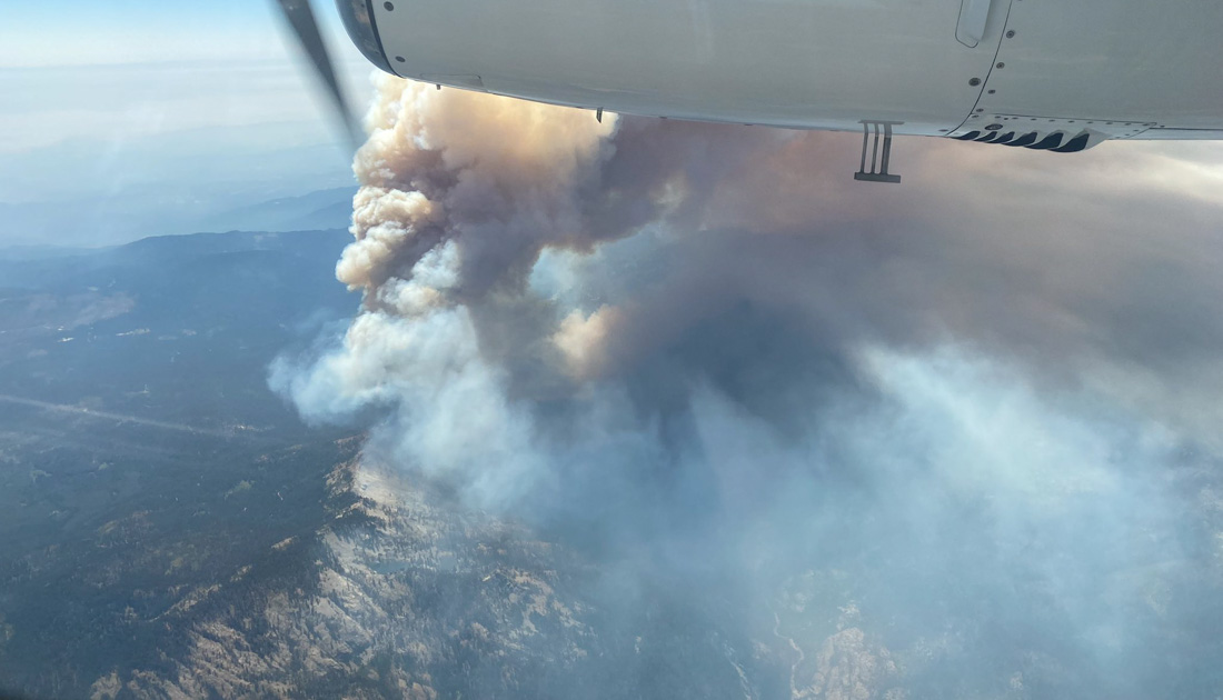
Late in the afternoon the fire activity increased substantially, sending up a substantial smoke column which was blown off to the north.
9:11 a.m. PDT July 10, 2022
With very little wind Saturday, the Washburn Fire continued to spread in and adjacent to the Mariposa grove of giant sequoia trees in Yosemite National Park in California. In spite of the relatively mild weather conditions, spot fires are occurring hundreds of feet out in front of the leading edge. The growth into the grove has been limited due to previous prescribed fires that reduced the amount of fuel on the ground, and by the efforts of firefighters. Some of the trees are about 3,000 years old.
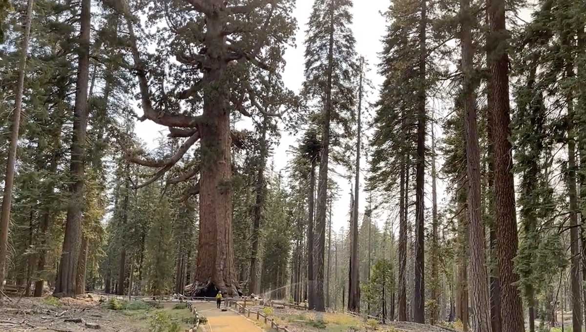
While the huge, very old trees are adapted to fire, they are not prepared for human caused climate change and the current “exceptional drought” conditions that have led to low soil and fuel moistures. The monster trees are more vulnerable to the existing weather and fuel conditions. They only grow in about 70 groves located on the western slopes of California’s Sierra Nevada Mountains. They are the largest trees on Earth in terms of volume.
The fire was mapped Friday night at 1,591 acres. Approximately 300 acres are in the Mariposa Grove of giant sequoias, on the west and north sides.
Smoke at times on Saturday degraded visibility to the point where retardant-dropping aircraft were grounded. Most of the movement of the fire was on the north end where it is working its way down-slope to the South Fork of the Merced River, which is also the southern edge of the South Fork Fire that burned 7,563 acres in 2017. The footprint of that 5-year-old fire scar will not stop the fire by itself, but there will be less resistance to control as it spreads through the lighter fuels.
The Washburn Fire is burning in mostly high load conifer litter with a heavy dead and down component as well as numerous standing dead trees.
There was very little wind on the fire Saturday and none overnight at Fish Camp, south of the fire and 1,000 feet lower where the minimum humidity Saturday was 31 percent but rose to 83 percent by 7:31 a.m. Sunday. Warmer and drier weather is predicted for the next few days.
The weather forecast for the fire area on Sunday calls for temperature around 80, relative humidity 26 percent, and ridgetop winds out of the west at 5 mph gusting to 12 mph in the afternoon. For Sunday night, 66 degrees, 33 percent RH, and 5 to 10 mph northwest winds in the evening shifting to east after 9 p.m. Monday should bring 83 degrees, 20 percent RH, and 5 to 10 mph winds out of the southeast shifting to southwest by 11 a.m.
Preparing for fire: The Grizzly Giant is the most renowned giant sequoia in Yosemite National Park. Standing at 209 feet it is the second largest tree in the Yosemite, and one of the most photographed.The Grizzly Giant is in the Mariposa Grove impacted by the Washburn Fire. pic.twitter.com/jnIlm9Gemn
— Yosemite Fire and Aviation Management (@YosemiteFire) July 10, 2022

For those of you worried about the big trees I talked to the YNP fire ecologist who has seen the grove recently. There are areas where fuels have been managed well recently (see the photo above where the back fire happened on the first day) and areas where little to nothing has occurred, so we should expect a range of damage from this fire. Generally, fire will prepare the soil for good germination next spring and where there are are too many subcanopy trees the high severity fire will kill trees and open up the area so vegetation that needs sunlight will have a chance to grow. While not an expert on the relationship between wildfire and the big trees during this drought and generally warmer conditions, I suspect that this fire will do more good than bad, atleast in the grove.
On another note, the grove (and most of the park that isn’t in the valley) is designated wilderness, which makes the use of aviation dropped retardant/ water interesting.
The pity is the part where little or nothing has been done with fuels over the many years that work could have been done, which are the areas in which we can now expect the most damage to the grove. Which is exactly the same issue that led to so many dead sequoias in Sequoia and Kings Canyon the last couple of years.
With regard to fire suppression in wilderness, pretty much anything goes in wilderness with the superintendent’s approval. No superintendent wants to be accused of somehow letting the fire burn. Notice how often full suppression was highlighted in media releases coming out of Lassen NP ( which is almost all designated wilderness) last year during the Dixie fire.
Interesting, thanks
Why have maps looking east and west? There’s been a convention for centuries of maps facing north.
Just because one can take a vertical video doesn’t mean one should. Take the TikTok generation off map making.
Richard, I agree that two-dimensional maps with north at the top has been the norm. But 3-D maps can provide a perspective that is not available looking straight down. In the case of the Washburn Fire, a 3-D map looking north is a view across the major drainage, the South Fork of the Merced River. The steep slopes are not visible. Views looking along the drainage gives what many people will say is very informative and interesting, illustrates the terrain firefighters are having to work on, and shows that those slopes will affect the behavior of the fire.
When we make a post a 3-D map, we always include a conventional map with north at the top.
We can go to the moon and we can’t figure this out? What I see once more is the “Us vs. Them” and the only thing that suffers is the planet, the special places, the animals and we who truly love these places.
Do the powers to be know how this fire started? Just wondering.
“Firefighters set up sprinklers at the Grizzly Giant sequoia during the Washburn Fire in Yosemite National Park, July 9, 2022. NPS image.”
When the flame-front gets close and/or arrives, how much of the water will have evaporated and what will be the temperature of of the fuel they’re supposedly protecting? What would happen if embers ignite fuel in the root-plate gaps, and/or just pile up and keep glowing. What will the wind do to the little sprays of water that might otherwise provide a degree of protection from ember accumulation? Is the water coming from a tanker or an inexhaustible source?
Other strategies and tactics?
Sprinklers are set up well in advance of a flame front so that they have ample time to saturate the surrounding fuels and raise the local-area RH, and are often run non-stop for days in advance of the fire.
They aren’t meant to directly fight flames or embers, they’re meant to make it much more difficult for flames and embers to ignite the fuels once they arrive.
The water most likely isn’t infinite, but given that the Grizzly Giant is a large and important resource, I’d suspect there will be resources dedicated to nothing but ensuring that the sprinklers keep running and soak everything nearby.
Come on folks. Get involved. Voice your opinions. Respect everyone. Be honest with your motives. If you have an affiliation with logging, say so. It’s ok. Name calling and assumptions is not working towards solutions. Managing forests these days is extremely complicated and dynamic. Be part of the solutions. I’m not affiliated with any groups.
Tom, that sounds like the “same ‘ol, same ol” from the enviros. They never think you are really trying to do “a good thing; i.e. protect the giants,” oh no, they always think you are trying to sneak some wood out of the “sacred areas.”
Dr. Biswell wrote quite a bit about the use of prescribed burns and how to protect the giant Sequoias in both Yosemite and Sequoia NPs. The USFS, in the 70s, recommended not only the use of prescribed burns, but logging of the “white woods” to reduce the density of non-redwoods and eliminate the “fuel ladders” from such into the redwoods. The latter was fought tooth and nail against such practices by the environmentalist organizations, Sierra Club and the like. Now, we see the results. You be the judge.
It’s true the Forest Service has rather consistently called for preburn thinning, although the NPS has generally used only prescribed fire without the general removal of “whitewoods.” The Mariposa Grove has been treated with prescribed fire and pile burning for decades; we will now see how resistant the grove is to wildfire. Ironically, a lawsuit has just been introduced seeking to block the more recent preburn strategy of thinning trees up to 20″ in diameter in Yosemite’s preparation for prescribed fire in the groves. The plaintiffs have called it “commercial logging,” although it plainly is not. Unfortunately, the park has chosen to stay silent on correcting this misperception, likely on the advice of its lawyers, which allows the “logging” misperception to proliferate in the media.