
Updated 6:50 p.m. PDT September 8, 2022
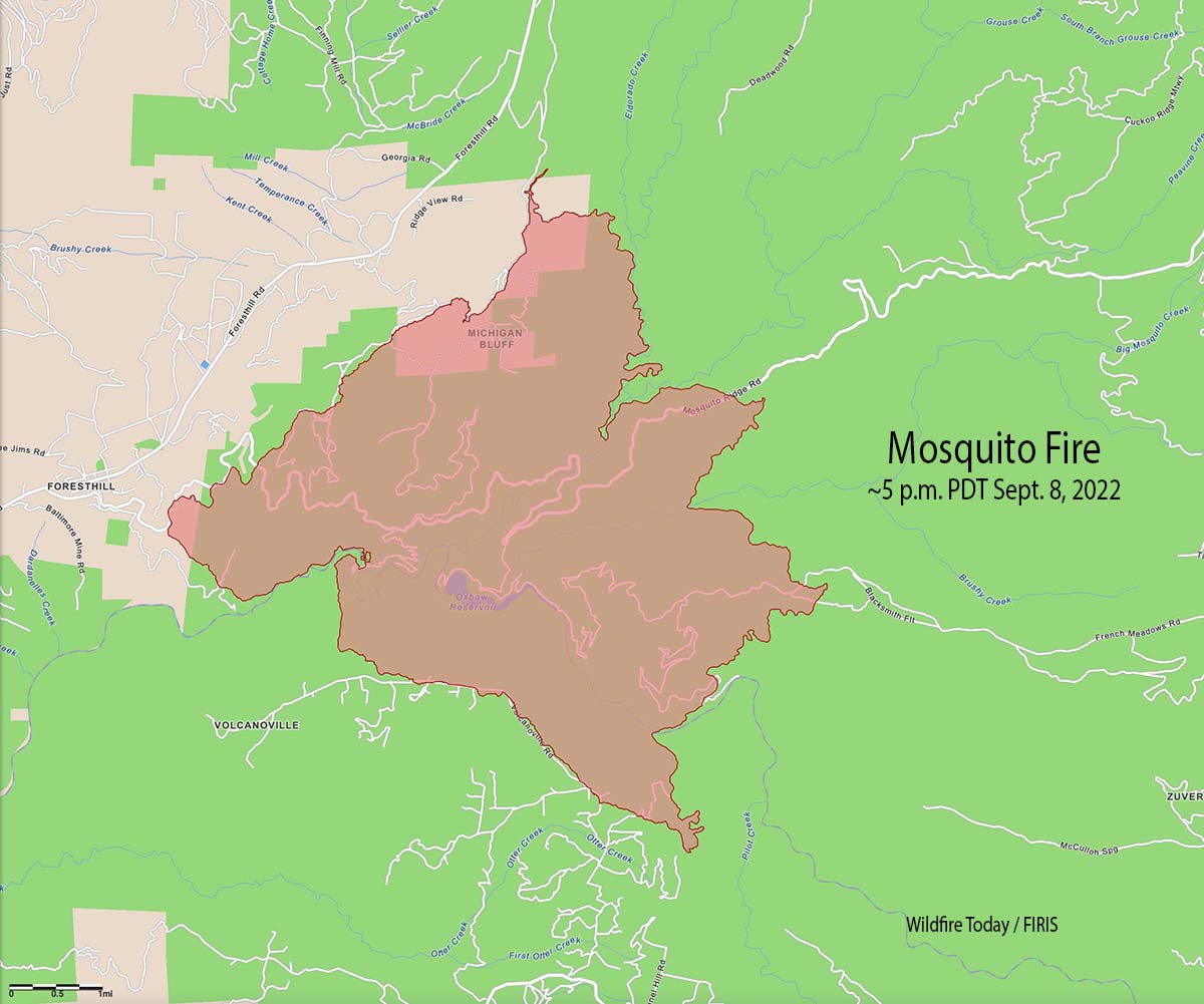
The Mosquito Fire east of Foresthill, California made an impressive run Thursday afternoon, growing from 8,265 acres at 1:30pm to 13,705 acres at 5pm — an increase of 5,440 acres in about 3.5 hours. Most of the growth was on the east half of the fire but the west side spread closer to Foresthill.
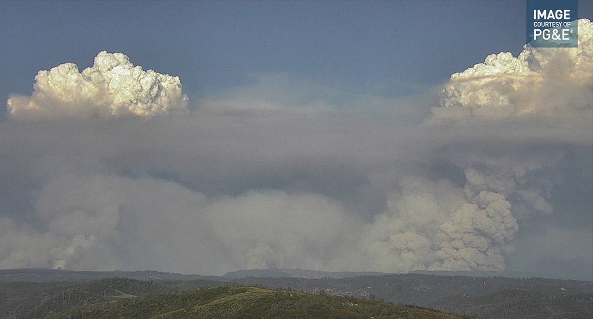
At times the rapidly expanding fire was putting up multiple convection columns topped by pyrocumulus clouds.
The number of areas under evacuation orders has increased. The Placer County Sheriff’s Office has produced a map with the details. You can follow the Sheriff on Facebook and Twitter for evacuation updates.
https://www.facebook.com/PlacerSheriff
https://twitter.com/PlacerSheriff
On Thursday structures were being threatened in Volcanoville and Foresthill.

On Thursday afternoon the temperature topped out at 101 degrees in Foresthill, the relative humidity dropped to 15 percent, and the wind was only 2 to 5 mph mostly out of the west. The forecast for Friday calls for 102 degrees, 15 percent RH, and winds out of the east and northeast around 5 mph shifting to the west/southwest at 6 to 12 mph in the afternoon with gusts up to 20 mph.
Updated 7:43 p.m. PDT September 7, 2022
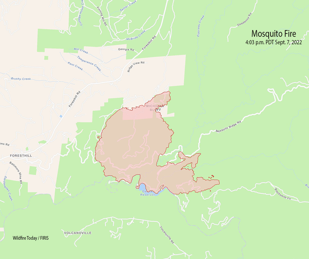
Wednesday afternoon the Mosquito Fire east of Foresthill, California spread significantly north and east. On the north side it moved into the Michigan Bluff area, while on the east side it spread beyond Gorman Ranch Road, along Mosquito Ridge Road, and across Blacksmith Fit.

At about 4 p.m. the FIRIS aircraft mapped it at 4,223 acres, an increase of approximately 3,000 acres since 11 a.m.
Right on target ✈️ ? @Ten_Tanker @accuweather #MosquitoFire #CAwx pic.twitter.com/WU5HAlzDqM
— Bill Wadell (@BillWadell) September 8, 2022
Evacuation information is below.
3:23 p.m. PDT September 7, 2022
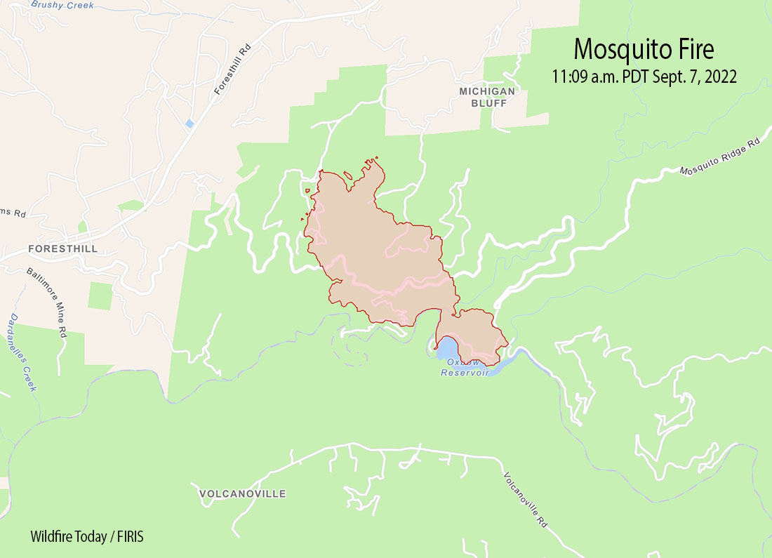
Evacuations have been ordered for the Mosquito Fire in the Foresthill area of Northern California, 17 miles northeast of Auburn.
Wednesday morning the fire was about a mile east of Foresthill, and was burning very actively during the afternoon. The estimated size at about 11 a.m. was 1,220 acres.
Most of the fire is within the boundaries of the Tahoe National Forest. It was reported at about 6:27 p.m. Tuesday September 6.
The Placer County Sheriff’s Office has ordered evacuations. They produced a map with the details.
You can follow Placer County Sheriff on Facebook and Twitter for evacuation updates.
https://www.facebook.com/PlacerSheriff
https://twitter.com/PlacerSheriff


Wow! That sat photo above looks very wicked. I know there have been a couple of fires in the area from recent memory, but all the short brush is bone dry. No moisture in the forecast but it is supposed to cool down. Heavy smoke downwind to Lake Tahoe.
I’m in western Nevada County, 30 miles NW of the fire. This (Saturday) morning the AQI numbers here vary from 455 to over 800. Visibility is probably less than a mile.
For reference, high school football games were to be cancelled last night if the AQI was over 150.
P.S. It looks like they saved Foresthill, knock wood. Great job!
I’m very familiar with the area this fire is burning in. Even on a normal summer day the heat coming up out of that canyon can feel like a blast furnace. Right now, the problem is the high temp both today and tomorrow will be pushing 100° with nighttime temps barely dropping to around 80°, along with California’s bone dry humidity.
It looks like CalFire has 5 S2Ts flying right now along with an Erickson MD-87, two of AeroFlite’s RJ85s and a DC-10. They’re doing their best to keep the fire away from the Foresthill Divide Road which runs on top of the ridge above the Middle Fork of the American River. Hopefully this will work and could possibly save a lot of homes, as Foresthill is fairly heavily populated.