
8:45 a.m. PDT Sept. 13, 2022

The two hikers who found themselves nearly entrapped by the rapidly spreading Bolt Creek Fire in northwest Washington near Skykomish have posted a video describing how they escaped.
After nearly reaching their goal of the top of Baring Mountain on Saturday September 10, they realized the smoke noticed earlier was from a fire that started that morning and had become a threat to their lives. The two of them shot video off and on during the entire hike, and on Sunday “Path Least Taken” posted an expertly-edited version on YouTube. He explained that he debated about publishing it, but did so “as an educational tool to point out all of the mistakes we made that ended up putting our lives in danger.”
During the escape they used wayfaring skills and technology tools to figure out how to descend the very steep slopes while avoiding the fire, which was at times exhibiting extreme flame lengths many times the heights of the trees, as you can see in the above image from their video.
When the Bolt Creek Fire was mapped Monday evening it had burned about 9,400 acres. In several places it has spread downhill nearly to US Highway 2. The fire activity was very much diminished Monday by much higher relative humidity. A weather station at Index northwest of the fire recorded very light winds Monday with the RH ranging from 57 to 92 percent, conditions not conducive to rapid fire spread.
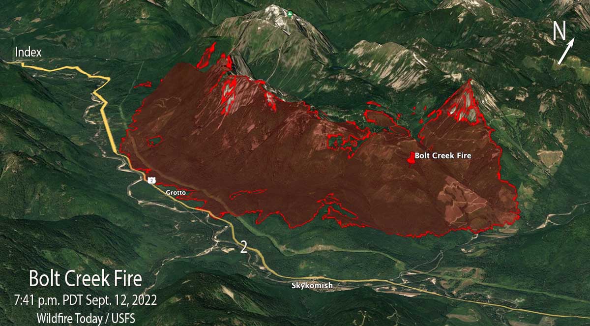
“It’s been a good day today for firefighters,” said Jim Cahill, a Washington State Department of Natural Resources spokesperson Monday evening.
As of Monday night US Highway 2 was closed from Milepost 32 to Milepost 50 and the community of Index was under a “Go Now” evacuation order.
The spot weather forecast for Tuesday predicts temperatures around 60 degrees, minimum RH of 87 percent, and light winds becoming 5 to 6 mph in the afternoon out of the northwest. Tuesday night the RH will rise to 100 percent and drop to only 86 percent on Wednesday. On Monday and Tuesday there is a 13 to 16 percent chance of very light rain, about 0.03″. The humidity is expected to remain mostly in the 80s and 90s through Sunday. The fire will not spread rapidly under these predicted conditions.

Thanks and a tip of the hat go out to Patrick.

I had climbed Mt. Barring ~5 times, and can understand the difficulty you guys faced. The climbing/hiking community is indebted to your brave attempt to document your ordeal and your wisdom in navigating a successful escape route.
Here’s my Monday morning quarter back observations:
A skinny sub-9mm rope at ~100ft could come in handy for emergency situations(like on a small cliff or talus slope).
The danger of talus slopes can be that they can avalanche, I was caught in one and sort of swam & rolled out of one(as my climbing partner watched in disbelief).
Great comments Oldguy, totally agree.
Heading downhill is just about never wrong. Eons ago when I was a guide I would tell people GO DOWNHILL till you come to a creek, follow that downstream and you’ll come to a road, follow that downhill and you’ll end up right back here at the ranch buildings.
But one year we had a doofus kid who didn’t understand what downstream meant; he explored upstream till he came to a road — and that was actually right back where he’d started.
?
I think the “video guys” did pretty much what they should have done once they spotted the fire(s).
Smoke prevented further assessment on their part so finding alternative routes down the mountain was a good strategy. One might say they could have “stayed in place,” but when it’s that windy and running out of water, downward was a decent choice. Drinking from the stream we saw has it’s own issues but I’ve done it dozens of times in the high country with no consequences. Slow and easy is the safest way to go.
Thanks for sharing your experience so that others may learn. Glad you are ok!!